Yosemite National Park: Waterfalls, Giants & Valley Views - 2026 Guide
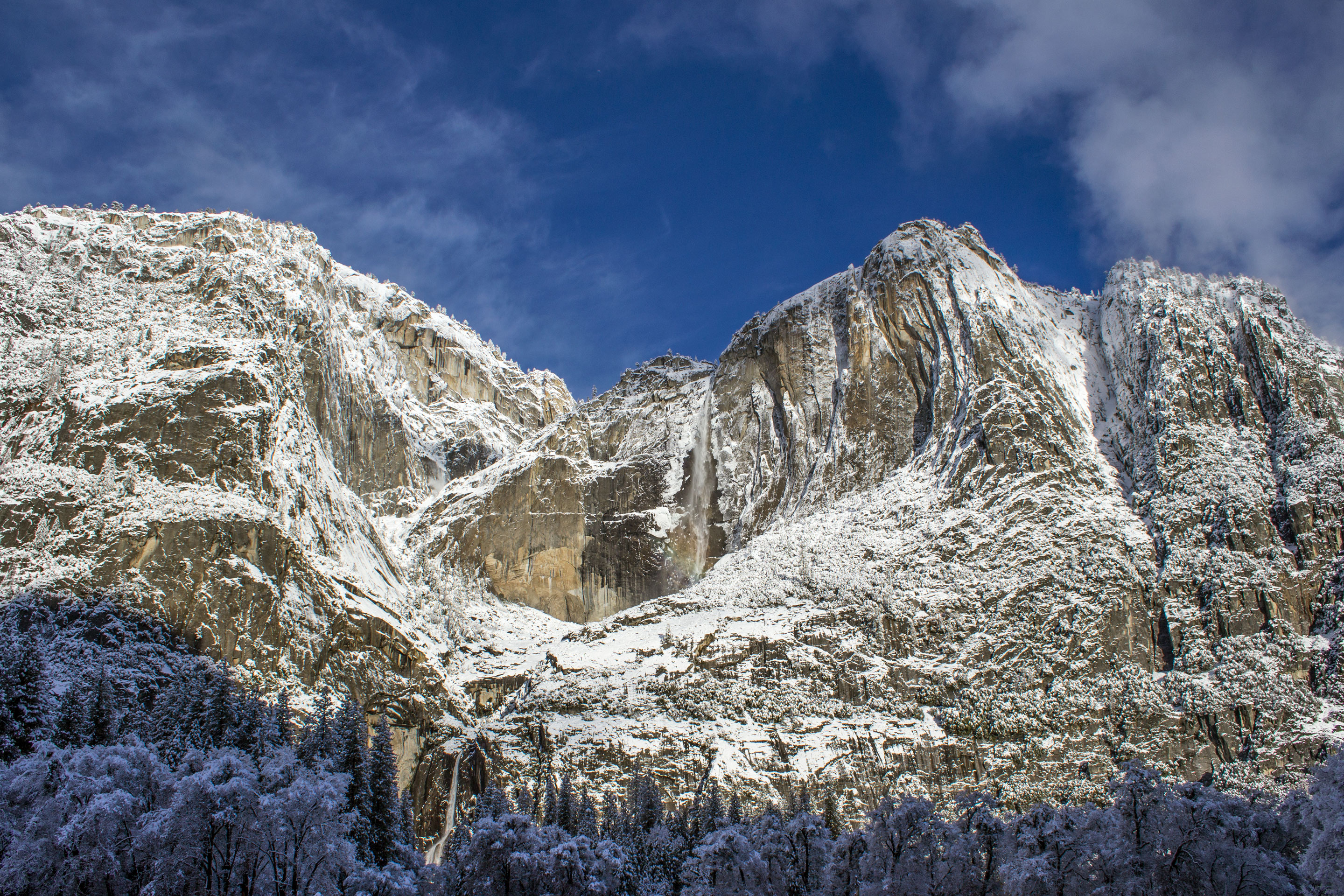
NPS via NPS.gov (Public Domain)
Yosemite National Park: Waterfalls, Half Dome & Complete 2026 Guide
9 min read
Park Guide
Plan your Yosemite trip with our 2026 guide: learn why waterfalls peak in spring, why the Valley fills by 9 AM, and how to pick one of five regions.
Your plans
This article contains affiliate links — we may earn a small commission at no extra cost to you.
At a glance
Entrance Fee
Private vehicle $35 · Motorcycle $30 · Per person $20Full fee schedule
Hours
Yosemite National Park is open 24 hours per day, 365 days per year.
Best Time
June-September (summer), September-October (fall colors)
Address
PO Box 577, Yosemite National Park, CA, 95389
Website
37.8488, -119.5572
Google MapsIntroduction
First-time visitors often underestimate the scale here. You'll read that El Capitan is a 3,000-foot granite wall, but that measurement only makes sense when you're standing at its base, watching climbers appear as colored specks moving inches per day. That's Yosemite's truth: statistics become abstract, and the experience reminds you of your place in this landscape. While the park spans 1,200 square miles of granite carved by water and time, most visits center on navigating the seven-mile corridor of Yosemite Valley to reach El Capitan, Yosemite Falls, and other landmarks.
First protected in 1864, this isn't just a collection of pretty sights. It's a functional landscape where glaciers carved the theater and the Merced River still writes the script. Over 95% of the precipitation falls between October and May, which means the famous waterfalls are often a springtime spectacle, reduced to a whisper or a stain on the rock by late summer. The mistake almost everyone makes is trying to see the whole park in a day. You can't. The drive from the Valley to Tuolumne Meadows alone is over an hour without traffic. The park asks you to pick a zone and settle in.
The Lay of the Land
Yosemite operates as five distinct regions, each with specific seasonal access. Knowing which areas are open during your visit prevents wasted travel time and disappointment.
Yosemite Valley is the busy, iconic core. This is where you find Tunnel View, Half Dome, Yosemite Falls, and the sheer face of El Capitan. Everything is close, the roads form a one-way loop, and the parking lots are full by 9 AM from April through October. This is also where most visitor services, lodging, and the free shuttle system are concentrated.
Wawona & the Mariposa Grove is the southern gateway, home to the historic Wawona Hotel and the park's largest collection of giant sequoias. The Grove is accessed by a shuttle from a parking area near the entrance. It's generally less frantic than the Valley, but the winding access road adds travel time.
Glacier Point & Badger Pass offers the overhead view. The Glacier Point Road climbs to a rim-top vista looking directly across at Half Dome. In winter, this road serves the Badger Pass Ski Area. A critical note: as of spring 2026, Glacier Point Road is closed for the season due to snow. It typically reopens in late May or June.
Tuolumne Meadows is the High Sierra. At 8,600 feet, this vast subalpine meadowland dotted with granite domes is accessible via the Tioga Road (Highway 120 across the park). This is the realm of backpackers and day hikers seeking cooler temperatures and thinner crowds. Its season is short; the Tioga Pass entrance from the east is closed from approximately November through late May or June.
Hetch Hetchy is the quiet northwest corner, a reservoir in a valley once similar to Yosemite Valley. It's open year-round but closes at sunset. It sees a fraction of the visitors and offers a more solitary experience.

Planning Your Visit
As of 2026, the entrance fee for a private vehicle is $35, valid for seven consecutive days. Motorcycles are $30, and individuals entering on foot, bike, or horse are $20 per person. Holders of the America the Beautiful Annual Pass get in free. A notable policy: non-U.S. residents aged 16 and older must pay an additional $100 fee on top of the standard entrance cost, unless they have an annual pass.
The park is open 24 hours a day, but specific areas like Hetch Hetchy operate from sunrise to sunset. No park-wide reservation is required for day use as of 2026, but that can change - always check the official website in the weeks before your trip. For overnight stays, you will need a reservation for any campground or lodging inside the park. Competition is fierce; sites for peak summer months are booked within minutes of becoming available on Recreation.gov, typically 5 months in advance.
The best time to visit depends on your tolerance for people and weather. Late May through June offers peak waterfall flow and wildflowers, with warm days. July and August bring the largest crowds, dry falls, and reliably warm Valley temperatures perfect for swimming in the Merced River. September and October are quieter, with crisp air and changing colors, but some high-country services begin to wind down. For a detailed breakdown, our guide on the best time to visit breaks it down month-by-month.
Getting There & Getting Around
You can drive to Yosemite year-round from the west via Highways 41, 140, and 120. The nearest major airport is Fresno Yosemite International (FAT), about a 90-minute drive to the south entrance. From the San Francisco Bay Area, expect a 4-hour drive. A crucial warning from rangers: GPS units are notoriously unreliable for routing within the park. They will often send you down closed roads or one-way streets the wrong way. Use a paper map or the official park map downloaded to your phone.
The parking situation here is the primary logistical challenge in Yosemite Valley. All parking lots are usually full between 9 AM and 4 PM from spring through fall. Your best bet is to arrive before 8 AM or use the free Yosemite Valley Shuttle, which loops past all major trailheads and sights. Park once at your lodging or in a large lot like Yosemite Falls or Curry Village and don't move your car again. In summer, consider biking - over 12 miles of paved paths crisscross the Valley floor.
Cell service drops out at the park boundaries and is sporadic at best. Assume you will have no signal in Yosemite Valley, at trailheads, or on most park roads. Download maps, reservation confirmations, and this guide before you arrive.

What to Do
Hiking is the primary activity, with options ranging from the paved, half-mile loop to the base of Lower Yosemite Fall to the thigh-burning climb up the Mist Trail to Vernal and Nevada Falls. The network of hiking trails is vast, with something for every ability level, but even the easy walks offer staggering views.
Scenic Driving is a park activity in itself. The 46-mile Tioga Road is a journey across the roof of the Sierra, passing Tenaya Lake and Tuolumne Meadows. Glacier Point Road delivers you to a view that makes the scale of the Valley finally make sense. Even the drive into the Valley on Wawona Road (Highway 41) through the tunnel is an event.
Rock Climbing needs no introduction here. Yosemite is a global climbing Mecca. From bouldering in Camp 4 to multi-day big wall ascents of El Capitan, the granite defines the sport. Even if you don't climb, spend an hour at the El Capitan picnic area with binoculars to watch the slow-motion drama on the wall.
Learning & Culture is woven throughout. Visit the Yosemite Museum to understand the deep history of the Ahwahneechee people. Watch the "Spirit of Yosemite" film for a sweeping overview. The Yosemite History Center in Wawona showcases the park's rustic architectural past.
Winter Sports transform the park. Badger Pass offers downhill and cross-country skiing, and the Glacier Point Road becomes a trail for snowshoers. The Valley under a blanket of snow is a quiet, magical contrast to the summer bustle. For organized outings, check the park's list of tours and guided experiences.
Wildlife Watching is a constant possibility. Black bears are active and require strict food storage. Mule deer graze in meadows at dawn and dusk. Steller's jays and ravens are ubiquitous. For the best practices and locations, our wildlife viewing guide has specifics.
Where to Stay
Inside the park, your options are historic lodges, rustic cabins, or campgrounds. The Yosemite Hotel (formerly Ahwahnee) is the iconic stone-and-timber lodge. Yosemite Valley Lodge offers modern rooms right at the base of Yosemite Falls. Curry Village provides canvas-tent cabins and basic rooms. All book up exactly 366 days in advance. For a full breakdown of pros, cons, and booking strategies, see our dedicated guide to lodging and accommodations.
Camping is the most popular and affordable option. Yosemite Valley has three major campgrounds - Upper Pines, Lower Pines, and North Pines - all near the Merced River. Camp 4 is the legendary walk-in camp for climbers. Outside the Valley, Hodgdon Meadow and Wawona are good first-night options, while Tuolumne Meadows puts you in the high country. Reservations are mandatory and extremely competitive. Our guide to camping options details every site.
If everything inside is full, gateway towns like El Portal, Mariposa, Oakhurst, and Groveland offer motels, vacation rentals, and additional dining. The trade-off is a 30-60 minute commute to the Valley each morning, putting you right in the traffic queue.

Seasonal Guide
April - June: The thaw. Waterfalls are thunderous, especially in May. The Valley is green, wildflowers bloom at higher elevations in June, and the Merced River runs high and fast. Tioga and Glacier Point Roads typically open in late May or June, unlocking the high country. Crowds build steadily through Memorial Day.
July - August: Peak season. Waterfalls are often dry or reduced to a trickle. Valley temperatures can reach the 90s, but the high country around Tuolumne Meadows offers perfect 70-degree hiking weather. Afternoon thunderstorms are common in the mountains. Crowds are at their maximum; patience is required.
September - October: The sweet spot. Crowds diminish after Labor Day. Days are warm, nights are cool. The aspen and dogwood trees turn gold and red. Tioga Road usually closes after the first significant snowstorm, often in October. A fantastic time for hiking and photography.
November - March: Winter quiet. The Valley gets rain and snow, dressing the cliffs in white. Badger Pass is open for skiing. Roads can require chains at any time. Many services and campgrounds are closed, but you can have iconic views almost to yourself. Always check road conditions at (209) 372-0200.
Practical Takeaways
- Arrive early or bike. The Yosemite Valley parking lot fill-time is 9 AM. If you're not parked by then, your day will involve circling. The free shuttle is efficient, but biking the 12+ miles of paved paths is the best way to beat the congestion.
- Your GPS will lie. It will try to route you down closed roads or the wrong way on one-way loops. Use the official park map.
- Store all food properly. This includes coolers, snacks, toothpaste, and anything scented in the provided steel bear lockers at trailheads and campgrounds. A bear accessing human food is often a dead bear.
- Water is non-negotiable. Carry at least one liter per person for every two hours of hiking. The Valley gift shop sells it for $4 a bottle. Bring your own.
- Check road status daily. As of spring 2026, Tioga Road and Glacier Point Road are closed for snow. These major arteries can open or close with little notice based on weather. Call the road hotline.
- Reservations are not optional. You cannot roll up and get a campsite or a lodge room. Plan and book months in advance.
- The waterfalls have a season. Yosemite Falls is often dry by August. Vernal and Nevada Falls flow longer but diminish. Spring is for waterfalls; summer and fall are for granite domes and high lakes.
- Look up. The most common mistake is to keep your eyes on the road or trail. The drama here is vertical. Watch for climbers on El Capitan, the shadow moving across Half Dome, the dipper birds flying through the mist at the waterfall's base.
- The park is bigger than the Valley. The crowds thin dramatically once you drive the hour up to Tuolumne Meadows or head to Hetch Hetchy. If the Valley feels overwhelming, escape to a different ecosystem.
- Leave the drone at home. They are prohibited in all national parks. The sound of a single drone can shatter the natural soundscape for hundreds of visitors.

Final Thoughts
Yosemite is a park that rewards preparation and punishes assumption. It asks you to contend with its crowds in exchange for moments of pure, unadulterated grandeur: the first glimpse of El Capitan through the windshield, the rainbow in the spray of a spring waterfall, the silent weight of a giant sequoia. It's not a wilderness you have to yourself, but a shared, monumental landscape that continues to define what a national park can be. Go with a plan, pack your patience, and be ready to look up until your neck aches. The scale is the point.
For more information, see our complete National Park Guide.
Recommended Gear
What experienced visitors bring to Yosemite National Park: Waterfalls, Half Dome & Complete 2026 Guide
Links may earn us a commission at no extra cost to you. We only recommend gear we believe in.
Hiking Essentials
Hydration Pack (3L)
Hands-free water for long trail days
Trekking Poles (Pair)
Save your knees on steep descents
Hiking Boots (Ankle Support)
Sturdy footwear for rocky, uneven trails
Sun & Heat Protection
Wide-Brim Sun Hat
Full coverage UPF 50+ protection at altitude
Insulated Water Bottle (32oz)
Keeps water cold in desert heat all day
Winter Gear
Microspikes / Traction Devices
Essential for icy rim trails in winter months
Packable Down Jacket
Lightweight warmth that stuffs into a pocket
Sources
- Official source: NPS — Yosemite National Park nps.gov/yose/index.htm
Explore More National Parks

Kings Canyon National Park: Complete Guide (2026)
Discover giant forests and deep granite canyons. Complete 2026 guide to Kings Canyon National Park —...

Sequoia National Park: Home of the World's Largest Trees — 2026 Guide
Sequoia National Park protects General Sherman, the largest living thing on Earth. 2026 tips for vis...

Pinnacles National Park: Condors, Caves & Volcanic Spires - 2026 Guide
Discover California condors, talus caves, and volcanic spire formations. Complete 2026 guide to Pinn...

Death Valley National Park: Earth's Hottest Place — Complete 2026 Visitor Guide
Conquer 3.4 million acres of extremes: Death Valley's 11,000-foot peaks, slot canyons, and dark skie...
Photo Gallery
More to Explore

Park Guide
Acadia National Park: Carriage Roads, Cadillac Mountain & 2026 Guide
Discover carriage roads, Cadillac Mountain, and rugged Maine coast. Complete 2026 guide to Acadia National Park — trails, fees, lodging, permits, and what rangers recommend.

Hiking Guide
Grand Canyon Hiking Trails: Day Hikes, Water Sources & Rim to Rim
Compare Grand Canyon hiking trails: Bright Angel, South Kaibab, Hermit, Grandview, and rim to rim, with distances, elevation, water stops, and trailhead access for each.

Best Of
Best of Glacier Bay National Park
The best of Glacier Bay is reached by boat: ranger-led day tours up the bay to the tidewater glaciers. What's worth it, how to book, and when to go (2026).

Campsite Guide
White Sands Backcountry Camping: Closed for 2026 — What to Know
As of 2026, backcountry camping at White Sands National Park is closed for site rehabilitation. What that means, and where to camp nearby instead.

Weather Guide
Guadalupe Mountains National Park Weather: Weather
Guadalupe Mountains National Park: weather guide guide updated 2026. Practical visitor information, reservations, and seasonal tips worth bookmarking before

Best Of
Best of Cuyahoga Valley National Park: Best Things to Do
Seeing a Cleveland Orchestra concert with the woods as your backdrop is a uniquely Cuyahoga Valley experience.
Sign in to join the conversation.
Sources & Attribution
Location data courtesy of the National Park Service (U.S. Department of the Interior). NPS data is public domain. Official NPS page.
Images: NPS; NPS; NPS; NPS; NPS.
Map data © OpenStreetMap contributors.
Park operations alerts: NPS.gov · Weather and weather hazards: National Weather Service · Live conditions.
Information may change. Always verify fees, hours, and conditions directly with the official source before visiting.
Did this guide help? Share it with a friend.