Pinnacles National Park's fractured spires and talus caves are the direct result of a 23-million-year geological journey. A volcanic field erupted near present-day Lancaster, California, then rode the Pacific Plate 195 miles northwest, fracturing as it moved. Today, this creates a landscape of deep canyons and walkable caves several miles inland from the coast. For a 2026 visit, focus on these practical priorities: choosing the correct entrance for your goals, locating the condors, timing cave access, and navigating the severe parking limitations. The park service's advice is blunt: plan your day around the parking availability, not your ideal itinerary.
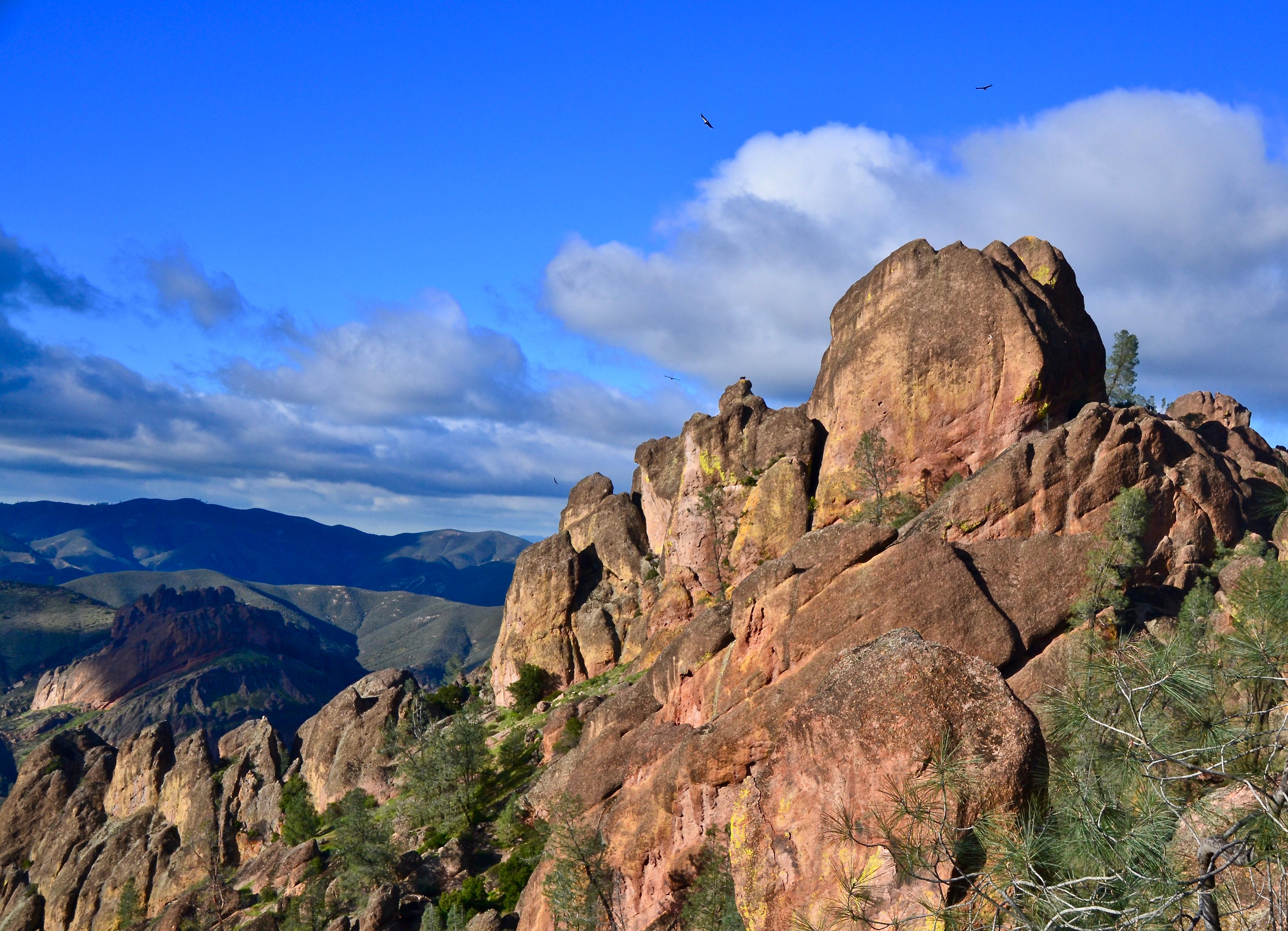
NPS via NPS.gov (Public Domain)
Pinnacles National Park: Condors, Caves & Volcanic Spires - 2026 Guide
9 min read
Park Guide
Plan your Pinnacles visit: choose east or west entrance, spot condors, time cave access, and manage parking limits. Essential tips for trails and fees.
Your plans
This article contains affiliate links — we may earn a small commission at no extra cost to you.
At a glance
Entrance Fee
Private vehicle $30 · Motorcycle $25 · Per person $15Full fee schedule
Hours
Entrance to the east side of Pinnacles National Park is open 24 hours, 7 days a week, including holi
Best Time
June-September (summer), September-October (fall colors)
Address
5000 East Entrance Road, Paicines, CA, 95043
Website
36.4903, -121.1814
Google MapsNavigating Two Separate Parks in One

First-time visitors to Pinnacles National Park are often caught off guard by a critical fact: the east and west sides do not connect by road. There is no through road. You pick an entrance and you stay on that side for the day. This isn't a minor detail - it dictates your entire experience.
The east entrance, off Highway 25, is open 24 hours. It leads to the main visitor hub at Bear Gulch, the campground, and the trailheads for the High Peaks and Bear Gulch Cave. The road here is wider and can handle RVs. The west entrance, off Highway 146 from Soledad, is a narrow, winding, one-lane road with limited hours (7:30 AM to 8:00 PM as of 2026). It services the Chaparral area and provides direct, steep access to the Balconies Cave and the backside of the High Peaks. Oversize vehicles should not attempt the west side road.
The common mistake - and almost everyone makes it - is trying to "see both sides" in one day without understanding the 90-minute drive required to go around. Rangers at the visitor center emphasize that you should choose your side based on your primary goal. Want the classic loop through the heart of the spires and a chance at the caves? Go east. Prefer a shorter, steeper climb into the rock formations with potentially fewer people? The west side has its appeal. Your entrance fee, valid for seven days, covers both sides, but your patience for driving does not.
The Parking Situation Here is Real
Parking is the single biggest logistical hurdle at Pinnacles. The Bear Gulch Day Use Area on the east side has maybe 50 spots. The Chaparral lot on the west fits 43 vehicles. They fill, without exception, by 9:30 AM on a pleasant spring Saturday. The park's alert system warns of "extremely high visitation" and delays between 10:00 AM and 3:00 PM. The overflow lot on the east side holds about 150 cars, but then you're adding a half-mile walk on the Bench Trail just to reach the main trailhead. Experienced visitors know to arrive before 8 AM, or plan to visit late afternoon. If the lots are full, rangers will turn you away. There is no street parking outside the gates.
Hiking Through the Heart of the Volcano

Forget gentle strolls. The trails here demand direct engagement with the volcanic rubble—scrambling over boulders, squeezing through narrow passages, and climbing staircases bolted into cliff faces. This terrain requires your full attention.
The Must-Do Loop: High Peaks and Caves
The Condor Gulch to High Peaks Trail Loop is the definitive Pinnacles experience—a 5.5-mile circuit with 1,300 feet of gain. Start on the Condor Gulch Trail, a steady climb that quickly opens up views over the chaparral. After 1.5 miles, you'll connect with the High Peaks Trail, where the route truly begins to define itself.
The trail narrows here. The "Steep and Narrow" section is exactly that: a series of steps and handrails carved and bolted directly into the rock spires by the Civilian Conservation Corps in the 1930s. Your calves will have strong opinions about every switchback on the way back up. The path winds through clefts in the rock so tight your pack might scrape both sides. From these overlooks you can see the entire Bear Valley and, on very clear days, the faint line of the coastal range to the west.
Most visitors then complete the loop by descending through Bear Gulch, past the reservoir, and through the upper section of Bear Gulch Cave if it's open. This turns a great hike into a memorable one, transitioning from sun-baked spires to cool, dark talus caves. For detailed breakdowns of this and other routes, see our guide to the hiking trails.
Talus Caves: Not Your Typical Cavern
The caves at Pinnacles are talus caves, not limestone. They formed when massive boulders tumbled into narrow canyons, piling up to create roofs over flowing streams. There are two main systems: Bear Gulch Cave on the east side and Balconies Cave on the west.
Bear Gulch Cave is more developed, with a constructed trail, handrails, and lighting installed by the CCC. The park closes sections seasonally to protect a colony of Townsend's big-eared bats, typically from mid-May through mid-July. When open, you'll walk in near-total darkness for sections, hearing the drip of water and feeling the temperature drop 20 degrees. You need a flashlight - your phone's light is insufficient. A headlamp is better, leaving your hands free to feel the cool, gritty sandstone walls.
Balconies Cave is wilder. The path is less defined, and you will use your hands to navigate over and under house-sized boulders. It's passable for most able-bodied adults, but not for anyone with significant mobility issues or a fear of confined spaces. The park website doesn't mention the specific sound - the hollow thwack of trekking poles on rock echoing in the dark, and the sudden, startling rush of a canyon wren's song from a slit of daylight above.
Wildlife, Skies, and the Condor Quest

The rocky cliffs and oak savannas of Pinnacles harbor a remarkable collection of life, but one species dominates visitor conversations: the California condor.
The Condor Watch
Pinnacles is one of the few places on earth where you can see a free-flying California condor without a guided tour. The population here is part of a central California flock that numbers around 100 birds as of 2026. They are massive. A condor's nine-and-a-half-foot wingspan is unmistakable - it looks like a person flying. They often ride thermal updrafts along the High Peaks in the late morning.
Your best bet for spotting them is on the High Peaks Trail or at the Condor Gulch overlook. Look for other visitors stopped dead in their tracks, necks craned, pointing silently at the sky. Rangers sometimes set up spotting scopes at the Bear Gulch reservoir. The birds are tagged with numbered wing markers; volunteers and staff keep a log, and they'll often tell you the life story of the condor currently circling overhead. It's a conservation success story you can witness firsthand. For more on the park's fauna, our wildlife viewing guide has deeper details.
Night Skies and Rare Bats
After the condors roost, another show begins. Pinnacles has minimal light pollution, earning it a designation as a good spot for night sky viewing. The milky way is visible on clear, moonless nights. The park occasionally hosts astronomy programs at the Pinnacles Amphitheater - check the schedule posted at the Bear Gulch Nature Center.
The same darkness that reveals the stars protects the resident bat colony in the caves. Those seasonal closures for the Townsend's big-eared bats are strictly enforced. They're a sensitive species, and the flash of a camera or the beam of a bright light can disturb their hibernation or pup-rearing. It's a good trade: a short closure for a critical refuge.
A critical alert as of 2026: The California Department of Public Health has issued a warning about potentially deadly poisoning from wild mushrooms in the area. The notice is blunt: avoid foraging. The risk of amatoxin poisoning is high.
Planning Your Visit: Seasons, Sleep, and Side Trips

The Mediterranean climate at Pinnacles means sharp seasonal shifts. Your experience in August will be fundamentally different from one in February.
When to Go
The park's official best time to visit is a complex answer. Spring (March-May) brings wildflowers - lupine and Indian paintbrush crowding the trail edges - and moderate temperatures. It also brings the largest crowds. Summer (June-September) is hot. Temperatures routinely spike above 100°F in the sun-baked High Peaks. If you hike then, you start at dawn and carry a minimum of one gallon of water per person. There is no shade on the ridge tops. Fall (October-November) is often ideal: warm days, cool nights, and thinner crowds. Winter is mild, with highs in the 60s, but rain can make the talus caves slippery and dangerous. The big swings in temperature between day and night happen year-round. Pack layers.
Where to Stay
Your only in-park option is the Pinnacles Campground, located just outside the east entrance. Operated by a concessionaire, it has 134 sites for tents and RVs (no hookups), plus tent cabins. It fills months in advance for spring weekends. The campground store sells basic supplies and souvenirs, and it's where you get your passport stamped. Showers are available for a fee. For a full breakdown of sites and reservations, see our guide to camping options.
If the campground is full, you'll look to nearby towns. Soledad, to the west, is the closest with motels. Hollister, to the north, offers more options. King City, to the south, is another possibility. None are what you'd call tourist hubs; they are agricultural valley towns. Manage your expectations accordingly. More details are in our lodging and accommodations resource.
Beyond Hiking: Climbing and Biking
Pinnacles is a historic rock climbing destination, with over a century of climbing history. The rock is volcanic breccia - rough and grippy, but it can be brittle. Traditional climbing is the norm, requiring you to place your own gear. Popular areas include The Balconies and Machete Ridge on the west, and Discovery Wall on the east. A free permit, available at the visitor centers, is required. The local climbing community is tight-knit; they have a saying about checking your holds twice.
Bicycles are allowed only on paved park roads, not on trails. This is primarily a transportation hack for when the parking lots are full. You can park at the campground and bike the two miles to the Bear Gulch trailhead, bypassing the full-lot closure. The road has narrow shoulders and traffic, so ride defensively.
Practical Takeaways

- Arrive Early or Late. The main parking lots (Bear Gulch, Chaparral) are full by 9:30 AM on weekends. Plan to be at the gate by 8 AM, or arrive after 2 PM when spots begin to open up.
- Choose Your Entrance Wisely. There is no connecting road. East side for Bear Gulch, the reservoir, and the main High Peaks loop. West side for direct Balconies Cave access and the Juniper Canyon climb. You cannot drive from one to the other inside the park.
- Bring Real Light for Caves. A headlamp is mandatory for the talus caves. Cell phone lights are inadequate. Check the park website or call ahead for cave closure status due to bats or flooding.
- Water is Non-Negotiable. Carry at least one gallon per person per day for summer hiking. There is no potable water on trails. The gift shop sells it for $4 a bottle. Bring your own.
- Look Up for Condors. Scan the skies along the High Peaks Trail late morning. Identify them by their immense size, black wings with white triangles on the underside, and numbered wing tags.
- Check for Alerts. Before you go, visit the official NPS website for Pinnacles. Verify cave status, fire restrictions, and any new warnings, like the 2026 alert on toxic wild mushrooms.
- Wear Sticky Shoes. The trails involve scrambling over polished rock and metal stairs. Hiking boots or shoes with good traction are essential, not optional.
- Have a Backup Plan. If the lot is full when you arrive, have another hike in mind. The Old Pinnacles Trail or the Bench Trail often have parking available at the overflow or Old Pinnacles lots when Bear Gulch is packed.
Final Thoughts

Pinnacles National Park rewards a specific type of engagement. It's not about passive sightseeing from a vista point. It's about the physical act of moving through the jumbled remains of an ancient volcano - climbing its spires, squeezing through its dark, cool caves, and sharing the sky with birds that were nearly lost to history. The logistics are a hurdle, but they're the filter that keeps the experience from becoming too polished. You earn the views here. You feel the grit of the trail dust and the chill of the cave air. You learn to watch the clock for the heat and the parking spaces. And in doing so, you connect with the place on its own terms: fractured, resilient, and quietly spectacular.
Recommended Gear
What experienced visitors bring to Pinnacles National Park: Condors, Caves & Volcanic Spires - 2026 Guide
Links may earn us a commission at no extra cost to you. We only recommend gear we believe in.
Hiking Essentials
Hydration Pack (3L)
Hands-free water for long trail days
Trekking Poles (Pair)
Save your knees on steep descents
Hiking Boots (Ankle Support)
Sturdy footwear for rocky, uneven trails
Sun & Heat Protection
Wide-Brim Sun Hat
Full coverage UPF 50+ protection at altitude
Insulated Water Bottle (32oz)
Keeps water cold in desert heat all day
Winter Gear
Microspikes / Traction Devices
Essential for icy rim trails in winter months
Packable Down Jacket
Lightweight warmth that stuffs into a pocket
Sources
- Official source: NPS — Pinnacles National Park nps.gov/pinn/index.htm
Explore More National Parks

Yosemite National Park: Waterfalls, Half Dome & Complete 2026 Guide
Discover towering waterfalls and granite valley walls. Complete 2026 guide to Yosemite National Park...

Sequoia National Park: Home of the World's Largest Trees — 2026 Guide
Sequoia National Park protects General Sherman, the largest living thing on Earth. 2026 tips for vis...

Kings Canyon National Park: Complete Guide (2026)
Discover giant forests and deep granite canyons. Complete 2026 guide to Kings Canyon National Park —...

Channel Islands: How to Actually Get There & What to Do When You Arrive (2026)
Discover California's Galapagos — island foxes and marine wilderness. Complete 2026 guide to Channel...
Photo Gallery
More to Explore

Park Guide
Acadia National Park: Carriage Roads, Cadillac Mountain & 2026 Guide
Discover carriage roads, Cadillac Mountain, and rugged Maine coast. Complete 2026 guide to Acadia National Park — trails, fees, lodging, permits, and what rangers recommend.

Hiking Guide
Grand Canyon Hiking Trails: Day Hikes, Water Sources & Rim to Rim
Compare Grand Canyon hiking trails: Bright Angel, South Kaibab, Hermit, Grandview, and rim to rim, with distances, elevation, water stops, and trailhead access for each.

Best Of
Best of Glacier Bay National Park
The best of Glacier Bay is reached by boat: ranger-led day tours up the bay to the tidewater glaciers. What's worth it, how to book, and when to go (2026).

Campsite Guide
White Sands Backcountry Camping: Closed for 2026 — What to Know
As of 2026, backcountry camping at White Sands National Park is closed for site rehabilitation. What that means, and where to camp nearby instead.

Weather Guide
Guadalupe Mountains National Park Weather: Weather
Guadalupe Mountains National Park: weather guide guide updated 2026. Practical visitor information, reservations, and seasonal tips worth bookmarking before

Best Of
Best of Cuyahoga Valley National Park: Best Things to Do
Seeing a Cleveland Orchestra concert with the woods as your backdrop is a uniquely Cuyahoga Valley experience.
Sign in to join the conversation.
Sources & Attribution
Location data courtesy of the National Park Service (U.S. Department of the Interior). NPS data is public domain. Official NPS page.
Images: NPS; NPS; NPS; NPS; NPS; NPS; NPS; NPS and others.
Map data © OpenStreetMap contributors.
Park operations alerts: NPS.gov · Weather and weather hazards: National Weather Service · Live conditions.
Information may change. Always verify fees, hours, and conditions directly with the official source before visiting.
Did this guide help? Share it with a friend.