For more, see hiking trails, camping options, lodging and accommodations, best time to visit, wildlife viewing, and tours and guided experiences.
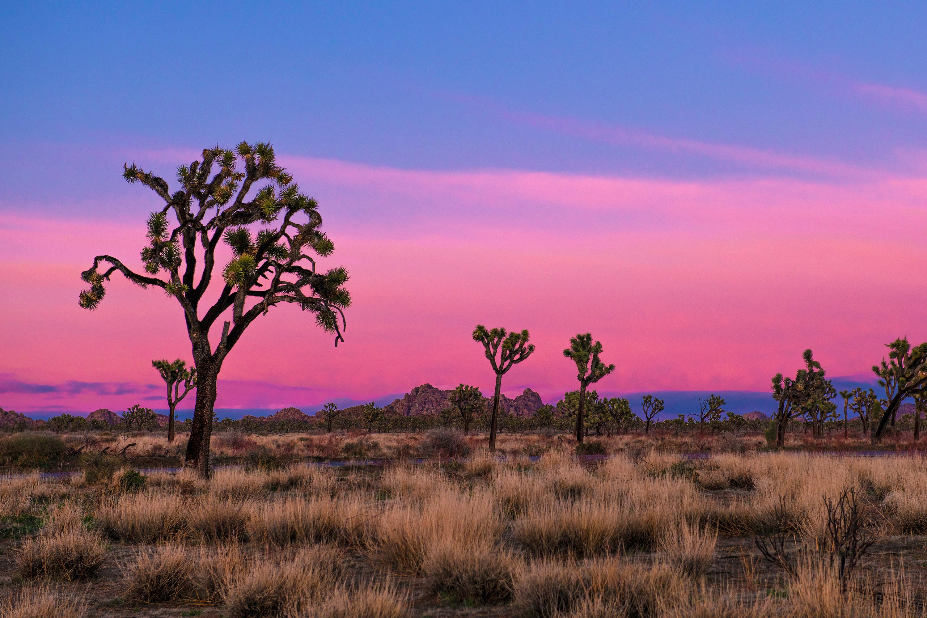
NPS via NPS.gov (Public Domain)
Joshua Tree National Park: Desert Boulders & Starry Skies — 2026 Guide
13 min read
Park Guide
The park operates 24/7, year-round. Many visitors don't know that the Joshua tree is a yucca, not a tree, and it thrives only between 2,000 and 6,000 feet.
Your plans
This article contains affiliate links — we may earn a small commission at no extra cost to you.
At a glance
Entrance Fee
Private vehicle $30 · Motorcycle $25 · Per person $15Full fee schedule
Hours
Joshua Tree National Park is open 24 hours a day, 7 days a week, 365 days a year. Visitation increas
Best Time
June-September (summer), September-October (fall colors)
Address
74485 National Park Drive, Twentynine Palms, CA, 92277-3597
Website
33.9142, -115.8398
Google MapsIntroduction
Joshua Tree National Park spans nearly 800,000 acres across San Bernardino and Riverside counties, where the Mojave and Colorado deserts meet. The iconic Joshua trees—actually yucca plants—stand alongside cholla cactus, and monzogranite boulders scatter the landscape like debris from a cosmic event. Choosing your entrance matters: the wrong one can cost you an hour of driving.
The park operates 24/7, year-round. Many visitors don't know that the Joshua tree is a yucca, not a tree, and it thrives only between 2,000 and 6,000 feet. Below that elevation, the Colorado Desert dominates with creosote bush and ocotillo. You'll notice the shift as you drive across the park.
The Lay of the Land
Joshua Tree National Park roughly runs northwest to southeast, a long rectangle of protected land that connects two very different worlds. Understanding the layout is essential before you figure out how to enter Joshua Tree National Park because your entrance choice determines your entire experience.
The Mojave Desert Zone (Western and Central Park)
This is the Joshua Tree section. The western half of the park sits at higher elevation, between 3,000 and 5,000 feet, and gets more winter precipitation. This is where you'll find the famous rock formations - Jumbo Rocks, Hidden Valley, Wonderland of Rocks. The vegetation is denser here, the boulders bigger, and the temperatures cooler by about 10 degrees compared to the southern end. Most first-time visitors spend their time here because this is the Joshua Tree they've seen in photographs.
The main road through this section is Park Boulevard, which runs roughly 30 miles from the West Entrance to the North Entrance. It's paved, well-maintained, and connects most major trailheads, campgrounds, and viewpoints. Drive time end to end is about 45 minutes without stops. You'll make stops.
The Colorado Desert Zone (Southern Park)
The southern third of the park drops in elevation to around 1,000 feet and changes character completely. The Joshua trees disappear. The landscape opens into wide bajadas (sloping plains) covered with creosote bush, cholla cactus, and ocotillo. This section is accessed via Pinto Basin Road, which runs 25 miles from the South Entrance near I-10 up to its junction with Park Boulevard.
Most visitors skip this section. That's a mistake. The Cholla Cactus Garden (currently closed for trail improvements as of early 2026, so check conditions) and the Cottonwood Spring oasis are worth the drive. The birding is better here, the crowds are thinner, and the light at sunset turns the Pinto Mountains a deep rust red.
The Wonderland of Rocks
This isn't an official zone, but it functions as one. Located between Park Boulevard and the northern park boundary, the Wonderland of Rocks is a maze of massive granite boulders, narrow canyons, and hidden washes covering roughly 20 square miles. There are no maintained trails through most of it. This is backpacking and route-finding territory. Rangers will tell you to carry a GPS and know how to use it before entering.

Planning Your Visit
Entrance Fees (as of 2026)
- Private vehicle: $30.00 - valid for 7 days, covers all passengers in a single non-commercial vehicle
- Motorcycle: $25.00 - covers up to 2 motorcycles with 4 total passengers
- Per person (walk-in or bike-in): $15.00 - 7-day pass
- America the Beautiful Pass: $80.00 for the year - covers all federal fee sites, including Joshua Tree. If you plan to visit more than two national parks in a year, this pays for itself.
Pay at the entrance station with credit or debit card. Cash is accepted but exact change is appreciated. If you arrive outside staffed hours (which happens - the park is open 24 hours), you must pay at the self-service fee station or pay online within 24 hours.
When to Go
Spring (March through May) and fall (October through November) are the sweet spots. Average highs sit around 85°F, average lows around 50°F. The wildflowers peak in March and April in a good rain year, though "peak" in the desert is relative - don't expect a carpet of color unless conditions align.
Summer (June through September) is punishing. Daytime temperatures exceed 100°F regularly and nights rarely drop below 75°F. The park empties out. If you go, be off the trails by 10 AM and carry a gallon of water per person per day. The trade-off: no crowds, and the night sky is at its clearest.
Winter (December through February) brings daytime highs around 60°F and freezing nights. It occasionally snows at higher elevations. Crowds are moderate - the holiday week between Christmas and New Year's is actually one of the busiest periods of the year.
Reservations
Campgrounds in Joshua Tree require reservations, and they fill up. Reservations open six months in advance on Recreation.gov. If you want a spot between October and May, book the day they become available. The park does not have a lottery system or last-minute release - what's gone is gone.
No reservation is needed to enter the park itself. Just show up, pay, and drive in. That's the simple part of how to enter Joshua Tree National Park.
Getting There & Getting Around
By Car
The nearest major airport is Palm Springs International (PSP), about 45 minutes from the West Entrance. Ontario International (ONT) is about 90 minutes away. Los Angeles International (LAX) is roughly 2.5 to 3 hours depending on traffic.
From I-10, take exit 117 for CA Highway 62 toward Twentynine Palms and Yucca Valley. This route gives you access to the West Entrance, the North Entrance, Black Rock Canyon, and Indian Cove. To reach the South Entrance, take exit 168 off I-10 and head north on Cottonwood Springs Road.
Which Entrance to Use
This is the central question when figuring out how to enter Joshua Tree National Park, and the answer depends on where you're going.
- West Entrance (Joshua Tree Village): The most popular entrance. Located on Highway 62 near the town of Joshua Tree. Drops you directly onto Park Boulevard near the main visitor center and the most popular trailheads. If you're coming from Palm Springs or Los Angeles, this is your entrance. Expect a line on weekends between 9 AM and noon.
- North Entrance (Twentynine Palms): Located on Highway 62 east of the town of Twentynine Palms. Puts you on the northern end of Park Boulevard near the Oasis of Mara and the park headquarters. Good option if you're staying in Twentynine Palms or coming from the east. Less crowded than the West Entrance.
- South Entrance (Cottonwood Spring): Accessed from I-10 exit 168. Puts you on Pinto Basin Road in the Colorado Desert section. If your plan is to hike the southern trails, camp at Cottonwood Campground, or avoid crowds entirely, use this entrance. It's 30 miles from the main Joshua Tree area, so factor that in.
- Black Rock Canyon Entrance: A smaller entrance on the western side of the park near Yucca Valley. Provides access to Black Rock Campground and the Hi-View Trail. Not a through route - you'll have to exit the same way you came.
- Indian Cove Entrance: Located on Highway 62 between Joshua Tree and Twentynine Palms. Provides access to Indian Cove Campground and trailhead. Also not a through route.
Parking Reality
Parking lots at popular trailheads fill by 8 AM on weekends and by 9 AM on weekdays during peak season. The Hidden Valley lot, Barker Dam lot, and Skull Rock pullouts are the worst offenders. Rangers will tell you that if you arrive after 10 AM at the main trailheads, plan to park along the road shoulder - which is legal as long as you're completely off the pavement and not blocking any gates or signs.
Cell Service
Cell service drops out about two miles inside any entrance. Verizon has the best coverage of the carriers, but don't count on it. There is no WiFi in the park. Download maps, directions, and any hiking information before you arrive. The NPS app works offline if you download the park content ahead of time.
Gas and Supplies
There is no gas station inside the park. The last gas on the west side is in Joshua Tree Village. On the south side, the last gas is at the I-10 exit. Fill up before you enter. The same goes for water - bring more than you think you need.

What to Do
Hiking
The park has over 200 miles of trails, ranging from the 0.4-mile Cap Rock loop to multi-day backpacking routes through designated wilderness. The trails in Joshua Tree are distinct from trails in other parks - many are marked only by rock cairns, the surface shifts from packed dirt to bare granite slabs without warning, and the exposure is relentless. There is no tree canopy. The sun finds you everywhere.
For a full breakdown of every trail worth your time, see our guide to the best hiking trails. The short version: Hidden Valley (1 mile, easy, classic boulder scenery), Barker Dam (1.1 miles, flat, great for beginners), Fortynine Palms Oasis (3 miles, moderate, 300 feet of elevation gain, no shade), and Skull Rock (1.7 miles, easy, popular for a reason).
Rock Climbing
Joshua Tree is one of the premier climbing destinations in the country. Over 8,000 established routes on the park's monzogranite boulders attract climbers from around the world. The rock is rough, the friction is excellent, and the routes range from easy boulder problems to multi-pitch trad climbs. A free climbing permit is required and available at any visitor center.
Stargazing
Joshua Tree is an International Dark Sky Park. On a moonless night, the Milky Way casts shadows. The park hosts evening ranger programs in campground amphitheaters during peak season, but you can stargaze from anywhere. The best spots are away from Park Boulevard - drive a few miles down a dirt road, turn off your headlights, and wait 20 minutes for your eyes to adjust. The experience is worth the drive alone.
Scenic Drives
Park Boulevard is the main scenic drive, and it's worth the full 30-mile run. Geology Tour Road is an 18-mile dirt route suitable for high-clearance vehicles (not necessarily 4x4, but don't try it in a sedan). Pinto Basin Road offers a different perspective - wide open views of the Pinto Mountains and Colorado Desert.
Wildlife Viewing
The park is home to desert bighorn sheep, coyotes, kit foxes, jackrabbits, and over 250 species of birds. The most famous resident is the desert tortoise, a threatened species that spends 95% of its life underground. If you see one, leave it alone - it's illegal to touch or disturb them. For a complete guide to what you might spot and where, see our wildlife viewing page.
Guided Tours
Ranger-led programs include guided walks, evening campfire talks, and the Keys Ranch tour - a 90-minute walk through a historic homestead that covers mining, ranching, and early desert settlement. For a full list of guided options and how to book, check our tours and guided experiences page.
Where to Stay
Inside the Park
The park has nine campgrounds with a total of roughly 500 sites. They are not equal.
- Jumbo Rocks Campground (124 sites): The largest and most centrally located. Great boulder scenery. No water. Reservations required.
- Black Rock Campground (99 sites): Located in the northwest corner. Has water and flush toilets. Good access to the Hi-View Trail.
- Indian Cove Campground (101 sites): Off Highway 62, not accessible from inside the park. Good for late arrivals. Group sites available.
- Cottonwood Campground (62 sites): In the southern Colorado Desert section. Has water and flush toilets. Less crowded. Good for birding.
- Ryan Campground (31 sites): Small, central, no water. Quiet.
- Hidden Valley Campground (44 sites): Popular, no water, pit toilets. Close to great climbing.
- Belle Campground (18 sites): Small, no water, pit toilets. First-come, first-served historically, but check current status.
- White Tank Campground (15 sites): Small, no water. Quiet and dark for stargazing.
- Sheep Pass Group Campground (6 group sites): Reservations required, for groups only.
All campgrounds require reservations on Recreation.gov as of 2026. Sites at Jumbo Rocks, Ryan, and Hidden Valley typically book out months in advance for spring and fall weekends. For a full breakdown of each campground and how to secure a spot, see our camping options guide.
Lodging Outside the Park
The gateway towns are Joshua Tree Village, Yucca Valley, and Twentynine Palms. Joshua Tree Village has the most character - a weird, wonderful mix of artists, climbers, and desert rats with a handful of good cafes and gear shops. Yucca Valley is bigger and more practical. Twentynine Palms is the largest town and has the most chain hotels.
For a complete list of places to stay, including vacation rentals, boutique hotels, and motels, see our lodging and accommodations guide.

Seasonal Guide
Spring (March-May)
The busiest season. Wildflowers bloom in March and April if winter rains were sufficient. Temperatures are ideal for hiking. All roads and facilities are open. Expect crowds at every trailhead and entrance station. The line at the West Entrance can stretch 30 minutes on weekends. Arrive before 8 AM or after 2 PM.
Summer (June-September)
The quietest season for good reason. Temperatures exceed 100°F regularly. Hiking is dangerous between 10 AM and 4 PM. The park's website recommends carrying one gallon of water per person per day and hiking only in the early morning or evening. The upside: you'll have entire trailheads to yourself. The night sky is spectacular. Climbing is possible in shaded areas but the rock gets hot enough to burn skin by midday.
Fall (October-November)
The return of good weather. October can still hit 90°F, but November brings perfect hiking conditions. Crowds build through the month but don't reach spring levels. This is the best time for backpacking - the days are warm, the nights are cool, and the water requirements are manageable.
Winter (December-February)
Days are cool (around 60°F) and nights are cold (freezing is normal). Snow is possible at higher elevations but rarely sticks for more than a day. Crowds are moderate except for the week between Christmas and New Year's, which is a madhouse. Winter is the best time for hiking the lower-elevation trails in the Colorado Desert section. The light is low and long, making photography excellent.
Practical Takeaways
- Download the NPS app and the park content before you arrive. Cell service drops dead within two miles of any entrance. The app works offline and includes trail descriptions, alerts, and maps. Third-party apps frequently provide inaccurate information - the park service has issued warnings about this.
- The Cholla Cactus Garden trail is closed for improvements as of early 2026. Check the park website before planning around it. The trail was scheduled to reopen in late spring, but dates shift.
- The Oasis of Mara trail is partially closed due to flood damage. The section past the oasis itself is closed. The paved loop near the visitor center remains open.
- Fill up with gas before entering the park. There is no gas station inside. The last gas on the west side is in Joshua Tree Village; on the south side, it's at the I-10 exit. Running out of gas in the park means a long walk to a payphone that may or may not work.
- The parking lot at Hidden Valley fills by 8 AM on weekends. If you arrive later, park along the road shoulder completely off the pavement. Do not block gates, trailheads, or emergency vehicle access.
- Bring more water than you think you need. The standard recommendation is one gallon per person per day. The air is dry (under 25% humidity most days) and you will dehydrate faster than you expect. Rangers at the visitor center emphasize this constantly because they deal with the consequences.
- The West Entrance has the longest lines. If you're coming from the east or staying in Twentynine Palms, use the North Entrance. If you're heading to the southern part of the park, use the South Entrance. The five minutes you spend checking a map can save you 30 minutes in a queue.
- Do not approach or touch desert tortoises. They are a threatened species protected by federal law. If you see one crossing the road, let it cross on its own. If you see one in a parking lot, leave it alone. The fine for harassing a tortoise starts at several hundred dollars.
- The park is open 24 hours, but your plans shouldn't be. If you're hiking, start early enough to finish before dark. If you're stargazing, know where you're driving and that you can't see the road without headlights. Search and rescue calls spike every year from people who underestimated the desert at night.
- The best time to photograph the boulders is the hour after sunrise. The low-angle light catches the texture of the monzogranite and the Joshua trees cast long shadows. By 10 AM, the light goes flat and harsh. Photographers who know the park shoot early and are packed up by lunch.

Final Thoughts
Joshua Tree is not a park you visit passively. It demands preparation, punishes complacency, and rewards anyone who takes it seriously. The heat, the dryness, the isolation - these aren't bugs in the experience, they're features. The park shows you what thrives against the odds: a yucca that looks like something from a Dr. Seuss drawing, a tortoise that lives 50 years underground, a cactus that glows gold in the sunset light.
This is a park for people who want to feel small. The boulders have been here for 100 million years. The Joshua trees live for several centuries. The night sky has been dark long enough to earn an International Dark Sky designation. Visitors who rush through, hitting the highlights between noon and 3 PM, miss the point entirely.
Come in spring or fall. Arrive early. Walk slowly. Stay until the stars come out. The park gives back exactly what you put into it, which in Joshua Tree's case means carrying your own water, watching your footing, and paying attention to the world around you. That's not a bad trade.
For more information, see our complete National Park Guide.
Related: joshua tree hiking guide
Related: trails in joshua tree guide
Recommended Gear
What experienced visitors bring to Joshua Tree National Park: Desert Boulders & Starry Skies — 2026 Guide
Links may earn us a commission at no extra cost to you. We only recommend gear we believe in.
Hiking Essentials
Hydration Pack (3L)
Hands-free water for long trail days
Trekking Poles (Pair)
Save your knees on steep descents
Hiking Boots (Ankle Support)
Sturdy footwear for rocky, uneven trails
Sun & Heat Protection
Wide-Brim Sun Hat
Full coverage UPF 50+ protection at altitude
Insulated Water Bottle (32oz)
Keeps water cold in desert heat all day
Electrolyte Mix Packets
Replace what water alone cannot during intense heat
Winter Gear
Microspikes / Traction Devices
Essential for icy rim trails in winter months
Packable Down Jacket
Lightweight warmth that stuffs into a pocket
Sources
- Official source: NPS — Joshua Tree National Park nps.gov/jotr/index.htm
Explore More National Parks

Death Valley National Park: Earth's Hottest Place — Complete 2026 Visitor Guide
Conquer 3.4 million acres of extremes: Death Valley's 11,000-foot peaks, slot canyons, and dark skie...

Channel Islands: How to Actually Get There & What to Do When You Arrive (2026)
Discover California's Galapagos — island foxes and marine wilderness. Complete 2026 guide to Channel...

Sequoia National Park: Home of the World's Largest Trees — 2026 Guide
Sequoia National Park protects General Sherman, the largest living thing on Earth. 2026 tips for vis...

Kings Canyon National Park: Complete Guide (2026)
Discover giant forests and deep granite canyons. Complete 2026 guide to Kings Canyon National Park —...
Photo Gallery
More to Explore

Park Guide
Acadia National Park: Carriage Roads, Cadillac Mountain & 2026 Guide
Discover carriage roads, Cadillac Mountain, and rugged Maine coast. Complete 2026 guide to Acadia National Park — trails, fees, lodging, permits, and what rangers recommend.

Hiking Guide
Grand Canyon Hiking Trails: Day Hikes, Water Sources & Rim to Rim
Compare Grand Canyon hiking trails: Bright Angel, South Kaibab, Hermit, Grandview, and rim to rim, with distances, elevation, water stops, and trailhead access for each.

Best Of
Best of Glacier Bay National Park
The best of Glacier Bay is reached by boat: ranger-led day tours up the bay to the tidewater glaciers. What's worth it, how to book, and when to go (2026).

Campsite Guide
White Sands Backcountry Camping: Closed for 2026 — What to Know
As of 2026, backcountry camping at White Sands National Park is closed for site rehabilitation. What that means, and where to camp nearby instead.

Weather Guide
Guadalupe Mountains National Park Weather: Weather
Guadalupe Mountains National Park: weather guide guide updated 2026. Practical visitor information, reservations, and seasonal tips worth bookmarking before

Best Of
Best of Cuyahoga Valley National Park: Best Things to Do
Seeing a Cleveland Orchestra concert with the woods as your backdrop is a uniquely Cuyahoga Valley experience.
Sign in to join the conversation.
Sources & Attribution
Location data courtesy of the National Park Service (U.S. Department of the Interior). NPS data is public domain. Official NPS page.
Images: NPS; NPS; NPS; NPS; NPS.
Map data © OpenStreetMap contributors.
Park operations alerts: NPS.gov · Weather and weather hazards: National Weather Service · Live conditions.
Information may change. Always verify fees, hours, and conditions directly with the official source before visiting.
Did this guide help? Share it with a friend.