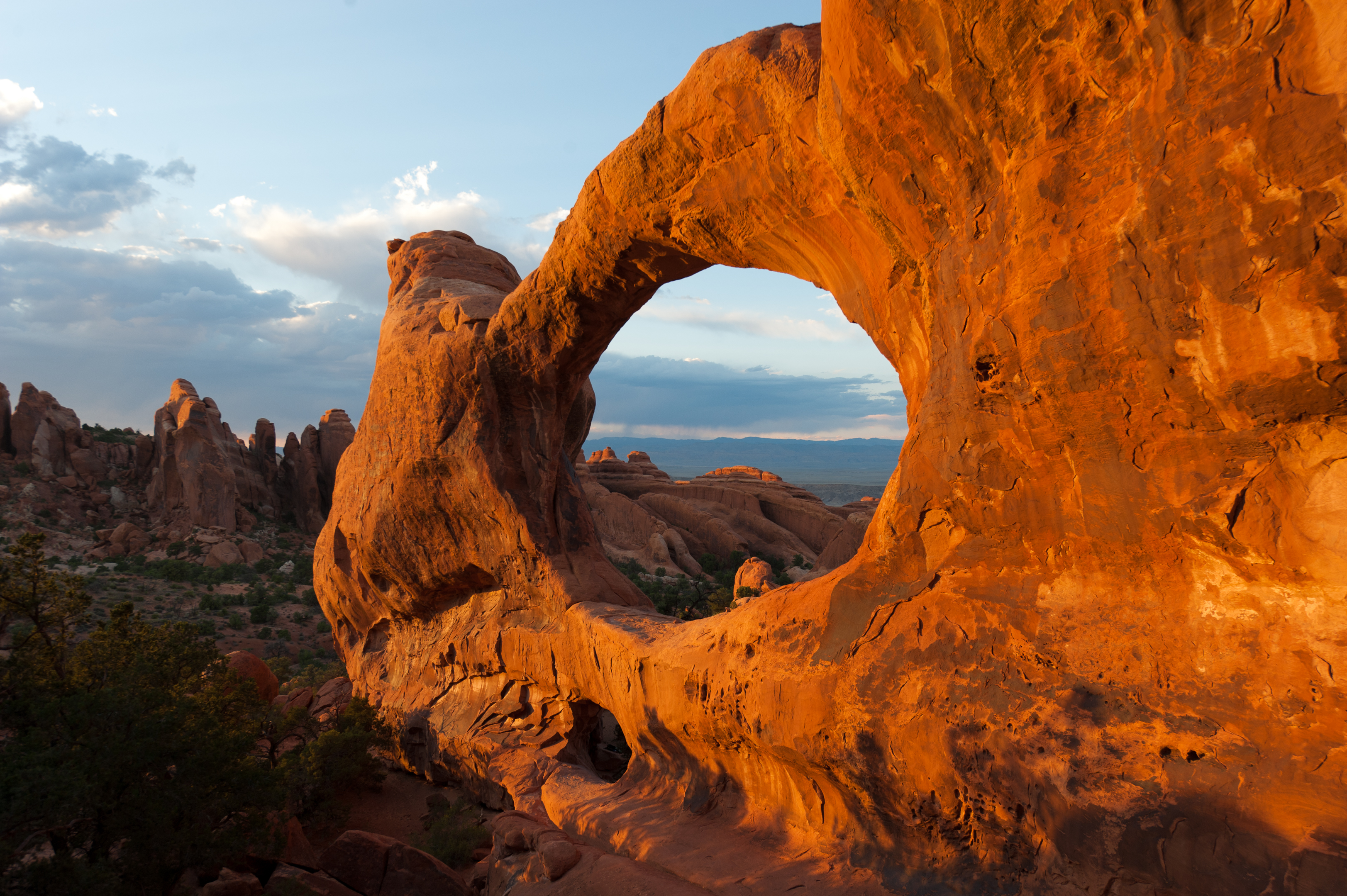
Arches was designated a national monument in 1929 and became a national park in 1971, preserving a landscape shaped entirely by erosion over deep time. You'll find yourself on a high desert plateau where more than two thousand sandstone arches hold firm against an expansive sky. The scale here plays tricks on the eye. From a vehicle, the formations appear almost miniature. On the trail, you learn that a single arch can stretch the length of a city bus, with the ground beneath it falling away into canyons that absorb all sound. This is a realm of heat, rock, and profound stillness, interrupted only by the wind and the crunch of your own boots on the gravel.
NPS via NPS.gov (Public Domain)
Fly to Arches National Park: Nearest Airports & Tips (2026)
11 min read
Park Guide
Discover where to fly to visit arches national park with our comprehensive guide. Expert tips, practical information, and insider knowledge.
Your plans
This article contains affiliate links — we may earn a small commission at no extra cost to you.
At a glance
Entrance Fee
Private vehicle $30 · Motorcycle $25 · Per person $15Full fee schedule
Hours
Arches National Park is generally open 24 hours a day, year-round. Fees apply. The park is very busy
Best Time
June-September (summer), September-October (fall colors)
Address
5 miles north of Moab, Utah, on US 191, Moab, UT, 84532
Website
38.7226, -109.5864
Google MapsOverview
Arches exists because of a specific geological recipe: a thick salt bed, layers of sandstone, and the relentless work of water and ice. The result is a concentration of natural stone arches unmatched anywhere on Earth. The colors shift from deep rust to pale peach depending on the sun, and the textures range from slickrock domes to jagged fins. It's not a lush park. Vegetation is sparse and tough - gnarled junipers, prickly pear, and Mormon tea holding on in cracks. The experience is defined by light and shadow, by the way afternoon sun turns Delicate Arch into a glowing crescent, and by the deep, cool blue of a desert night sky crowded with stars.
The park covers 76,679 acres of the Colorado Plateau. Rangers will tell you that number matters less than the feeling of exposure once you leave your vehicle. There's little shade, water is scarce, and the trails are mostly across open rock. First-time visitors are often caught off guard by the sheer physicality of the place. The common mistake - and almost everyone makes it - is underestimating the desert. A two-mile hike here demands more water and preparation than a five-mile forest trek elsewhere. This guide is built on that collective, hard-earned knowledge from rangers and returning visitors.
Quick Information
Here are the practical details you need. For 2026, a private vehicle pass costs $30 and is good for seven days. Motorcycle entry is $25, and individuals on foot, bicycle, or as a passenger pay $15 per person. Visitors aged 15 and under enter free. The park gates are open 24 hours a day, every day, though the entrance station only staffs daylight hours. Parking is your primary logistical challenge. From March through October, most trailhead lots reach capacity by 9 AM. Our standing advice is clear: if a lot is full, do not park on vegetation or block roadways. Return later. For balanced temperatures and thinner crowds, aim for April to May or mid-September through October. Don't rely on your phone; cell service is typically nonexistent beyond the entrance. You'll find restrooms at the visitor center and major trailheads—these are vault toilets. The visitor center and several roadside viewpoints are accessible, but be prepared: most trails traverse raw, uneven sandstone.

Getting There
The answer to where to fly to visit Arches National Park has two parts. The closest airport is Canyonlands Field (CNY) in Moab, about 10 miles from the park entrance. It's served by a few regional carriers. The major hub is Salt Lake City International (SLC), a 4-hour drive to the north. Most visitors fly into SLC and rent a car.
The park has one entrance, located five miles north of Moab, Utah, on US 191. It's a well-marked turnoff with a large sign. From Moab, drive north on Main Street (which is US 191) for five miles and turn right at the stoplight into the park. If you're coming from Interstate 70, take exit 182 at Crescent Junction and drive south on US 191 for 28 miles, then turn left at the stoplight.
Drive times are straightforward but can be misleading. The entrance gate is only 5 miles from Moab, but the park alert for 2026 warns of potentially long wait times at the entrance station. On a busy spring morning, you could sit in a line of cars for over an hour. The strategy is simple: be at the gate before 8 AM or plan to arrive after 3 PM. Once inside, the main park road is 18 miles long, ending at the Devils Garden trailhead. Allow 30-45 minutes of driving time to reach the far end from the entrance, not including stops. There is no public transportation within the park; your personal vehicle is essential.
What to Expect
Expect a landscape of sharp contrasts. The ground is mostly bare Navajo sandstone, a pale orange rock that holds the day's heat long after sunset. The temperature can swing 40 degrees between day and night. In summer, midday rock surfaces can burn bare skin. In winter, that same rock can be covered in a thin, treacherous layer of ice.
The terrain dictates the experience. Trails aren't dirt paths; they're cairn-marked routes across slickrock, through sandy washes, and up rocky fins. The sound of your hike is the grating of shoe rubber on gritty sandstone and the occasional hollow thwack of a trekking pole. The smell is dry air, dust, and, after a rare rain, the sharp scent of wet desert sage.
Wildlife is present but not always obvious. You might see a white-tailed antelope squirrel darting between rocks, hear the croak of a common raven echoing off a fin, or spot a desert cottontail at dusk. Larger animals like mule deer and coyotes are more common in the early mornings near the park boundaries.
First-time visitors consistently underestimate three things: the sun's intensity, the complete lack of drinking water on trails, and how quickly a small parking lot fills. The view from your car is passive. The view from the trail is immersive, and it requires active preparation.

Top Attractions & Points of Interest
Delicate Arch
This is the arch you've seen on license plates. The 3-mile round-trip hike to its base is strenuous, gaining 480 feet in elevation across exposed slickrock with no shade. The trail narrows here on the final ledge before the arch comes into view. Most visitors aim for sunset, when the arch glows against the sky, but that means hiking back in the dark - bring a headlamp. The smaller, less crowded Wolfe Ranch cabin and petroglyph panel are at the trailhead. Parking for this trail is notoriously competitive and is often full by 8 AM.
Landscape Arch
Located at the Devils Garden trailhead at the park's far end, this is one of the world's longest natural stone spans, stretching 306 feet. A mostly flat, 1.6-mile round-trip gravel trail leads to a viewpoint. You can no longer walk under it due to rockfall. The sight of its thin, fragile ribbon of rock against the sky is a lesson in impermanence. This parking lot fills second only to Delicate Arch.
The Windows Section
This area offers the highest concentration of easily accessible major arches. A one-mile round-trip, relatively flat loop takes you to North Window, South Window, and Turret Arch. You can view them from the loop or take a short spur to stand underneath. It's a good option for late afternoon photography. The separate, half-mile trail to Double Arch is worth the extra few minutes - it's two massive arches sharing a common stone leg.
Park Avenue
More canyon than arch, this is often the first major stop after the visitor center. A one-mile trail (one-way) descends into a canyon lined with massive sandstone monoliths that resemble a skyscraper skyline. You can do it as a 2-mile out-and-back or arrange a shuttle with a second car at the Courthouse Towers viewpoint. The morning light here is sharp and dramatic.
Fiery Furnace
This is a maze of narrow sandstone canyons. Access requires either a permit for a self-guided trip (obtained in person at the visitor center after watching a safety video) or a spot on a ranger-guided hike (reservations open months in advance). It's not a marked trail but a route-finding challenge. The experience is about the cool, shaded depths, tight squeezes, and quiet. Not for the claustrophobic.
Balanced Rock
A quick, 0.3-mile loop circles this iconic formation where a 3,600-ton boulder perches precariously on a slender pedestal. It's a perfect roadside stop. The parking lot is large, but it still fills up by mid-morning. The view is just as good from the road if you're pressed for time.
Devils Garden
This is the park's premier hiking area, beyond Landscape Arch. The full Primitive Loop trail is 7.2 miles and passes by eight named arches, including Partition Wall and Navajo Arch. The trail becomes progressively more difficult, involving scrambling up rock fins and navigating narrow ledges. Most visitors turn around at Landscape Arch or Double O Arch (4.2 miles round-trip). Start early with at least 3 liters of water per person.
Activities
Hiking
Hiking is the primary activity. The park's hiking trails range from paved, wheelchair-accessible paths like the Park Avenue viewpoint to strenuous, exposed slogs like the Delicate Arch trail. The golden rule: carry a minimum of one gallon (4 liters) of water per person, per day. Trail surfaces are abrasive sandstone, sand, and rock. Good traction shoes are non-negotiable. Early morning is your best bet for parking and tolerable heat.
Photography
The light is everything. Sunrise at the Courthouse Towers or Mesa Arch (technically in Canyonlands, but nearby) and sunset at the Windows or Delicate Arch are the classic shots. Midday light is harsh and flat. A polarizing filter helps cut the glare off the red rock. Tripods are essential for low-light arch shots and night photography, for which the park is an International Dark Sky Park.
Stargazing and Astronomy
With minimal light pollution, the night sky is a major attraction. The Milky Way is often visible to the naked eye. Rangers occasionally host night sky programs. Any pullout away from the entrance road is a good spot. The Balanced Rock parking area is a popular, easy-to-access choice. A red-light headlamp preserves your night vision.
Camping
The only developed campground is Devils Garden, located 18 miles from the entrance. It has 51 sites, flush toilets, and water. Reservations are required from March through October and are released six months in advance. They sell out within minutes. For camping options outside the park, look to the extensive BLM land surrounding Moab. Backcountry camping requires a permit, available at the visitor center.
Other Activities
Mountain biking is not allowed on park trails but is world-class on the surrounding BLM and Slickrock trails near Moab. Rock climbing is permitted but regulated; check at the visitor center for specific route closures, especially around raptor nesting sites. The Junior Ranger program is a hit with kids, with booklets available at the visitor center.

Seasonal Guide
Spring (April-May): This is the prime window. Daytime highs are 60-80°F, wildflowers like globe mallow and paintbrush bloom, and crowds are heavy but manageable with an early start. Afternoon winds are common.
Summer (June-August): Intense. Highs routinely exceed 100°F. Strenuous hiking after 10 AM is not advised. Monsoon season (July-August) brings brief, violent thunderstorms and flash flood risk in canyons. If you visit now, your activity window is 5 AM to 10 AM.
Fall (September-October): Another ideal season. Crowds thin after Labor Day, and temperatures return to the 60-80°F range. It's the most reliable time for comfortable, all-day exploration.
Winter (November-March): Cold and quiet. Highs average 30-50°F, with lows often below freezing. Snow dusts the red rock, creating contrast. Ice can make trails like the Delicate Arch ledge extremely hazardous. Some services are reduced, but you'll have the arches largely to yourself.
For a detailed monthly breakdown, our guide on the best time to visit goes deeper.
Practical Information
The $30 vehicle entrance fee is your main cost. An America the Beautiful Interagency Annual Pass ($80) covers this fee and is worth it if you'll visit more than two national parks in a year. The park does not currently have a timed entry reservation system as of 2026, but this can change; always check the official website before your trip.
For lodging and accommodations, Moab is your basecamp, offering everything from hotels and motels to vacation rentals. It's wise to book months in advance for spring and fall. Dining and gas are available in Moab; there are no services within the park beyond the visitor center's bookstore and water bottle fill station. The gift shop sells water for $4 a bottle. Bring your own.

Safety & Preparation
This is a high-desert environment. Dehydration and heat illness are the most common emergencies. Drink water consistently, not just when you're thirsty. A gallon per person, per day. Wear sun protection: hat, sunglasses, and sunscreen on all exposed skin.
Stay on designated trails. Cryptobiotic soil - the black, crusty living ground cover - is extremely fragile and can take decades to recover from a single footprint. Walking on it is destructive and illegal.
Flash floods are a real and sudden danger in washes, canyons, and low-lying areas, especially during summer monsoon storms. Never enter a narrow canyon if rain is forecast. If you hear a roaring sound or see water rising, seek higher ground immediately.
Let someone know your itinerary. Cell service drops out at the park entrance. The emergency phone number is 911, but response times can be long in remote areas. The park's direct line is (435) 719-2299.
Insider Tips
- The Second Lot: For Delicate Arch, if the main Wolfe Ranch lot is full, drive another quarter-mile up the road to the Delicate Arch Viewpoint lot. The lower viewpoint is wheelchair accessible. The upper viewpoint requires a short, steep hike but gives you a distant but clear look at the arch across a canyon.
- Sunset Alternative: Everyone crowds the Windows for sunset. The nearby Garden of Eden viewpoint, just a pull-off on the road, offers an equally spectacular sunset panorama over the Courthouse Towers with a fraction of the people.
- Beat the Heat (and Crowds): In summer, arrive at the entrance gate by 6 AM. You'll drive right in, get a parking spot anywhere, and be done with your hike before the heat becomes dangerous. A pre-dawn start with a headlamp for Delicate Arch is a memorable experience.
- Check the Logbook: At the visitor center, look at the trail condition logbook. Rangers and recent hikers post updates on ice, mud, or difficult route-finding, especially for the Fiery Furnace and Devils Garden Primitive Loop.
- The Moab Shuttle: During peak seasons, consider the seasonal shuttle service that runs from Moab to the park entrance. It doesn't go into the park, but it can save you the entrance line if you're biking in or have a non-vehicle pass.
- Post-Storm Magic: If you're there after a rain, head out immediately. The red rock becomes intensely saturated in color, potholes in the slickrock fill with water, and the air is clear and cool.
- For a Quieter Experience: The park empties out significantly after 3 PM as day-trippers leave. An evening drive to the far end of the park for a shorter hike or just to watch the light change can be peaceful. Just remember there are no lights on the roads after dark.
Links may earn us a commission at no extra cost to you. We only recommend gear we believe in. For guided excursions, from canyoneering to scenic flights, see our page on tours and guided experiences. And to know what creatures you might spot, from peregrine falcons to midget-faded rattlesnakes, our wildlife viewing guide has the details.
For more information, see our complete National Park Guide.
Recommended Gear
What experienced visitors bring to Fly to Arches National Park: Nearest Airports & Tips (2026)
Links may earn us a commission at no extra cost to you. We only recommend gear we believe in.
Hiking Essentials
Hydration Pack (3L)
Hands-free water for long trail days
Trekking Poles (Pair)
Save your knees on steep descents
Hiking Boots (Ankle Support)
Sturdy footwear for rocky, uneven trails
Sun & Heat Protection
Wide-Brim Sun Hat
Full coverage UPF 50+ protection at altitude
Insulated Water Bottle (32oz)
Keeps water cold in desert heat all day
Electrolyte Mix Packets
Replace what water alone cannot during intense heat
Winter Gear
Microspikes / Traction Devices
Essential for icy rim trails in winter months
Packable Down Jacket
Lightweight warmth that stuffs into a pocket
Sources
- Official source: NPS — Arches National Park nps.gov/arch/index.htm
Explore More National Parks

Canyonlands National Park: Utah's Wildest Canyon Country - 2026 Guide
Canyonlands has zero restaurants inside the park. 2026 guide to where to eat near each of its three...

Capitol Reef National Park: The Wrinkle in the Earth - Complete 2026 Guide
Discover what is capitol reef national park known for with our comprehensive guide. Expert tips, pra...

Black Canyon of the Gunnison National Park: One of America's Most Dramatic Canyons - 2026 Guide
Discover Black Canyon of the Gunnison National Park national park guide with our comprehensive guide...

Mesa Verde National Park: Ancient Cliff Dwellings & Ancestral Puebloan Sites - 2026 Guide
Discover ancient Ancestral Puebloan cliff dwellings and mesa ruins. Complete 2026 guide to Mesa Verd...
Photo Gallery
More to Explore

Park Guide
Acadia National Park: Carriage Roads, Cadillac Mountain & 2026 Guide
Discover carriage roads, Cadillac Mountain, and rugged Maine coast. Complete 2026 guide to Acadia National Park — trails, fees, lodging, permits, and what rangers recommend.

Hiking Guide
Grand Canyon Hiking Trails: Day Hikes, Water Sources & Rim to Rim
Compare Grand Canyon hiking trails: Bright Angel, South Kaibab, Hermit, Grandview, and rim to rim, with distances, elevation, water stops, and trailhead access for each.

Best Of
Best of Glacier Bay National Park
The best of Glacier Bay is reached by boat: ranger-led day tours up the bay to the tidewater glaciers. What's worth it, how to book, and when to go (2026).

Campsite Guide
White Sands Backcountry Camping: Closed for 2026 — What to Know
As of 2026, backcountry camping at White Sands National Park is closed for site rehabilitation. What that means, and where to camp nearby instead.

Weather Guide
Guadalupe Mountains National Park Weather: Weather
Guadalupe Mountains National Park: weather guide guide updated 2026. Practical visitor information, reservations, and seasonal tips worth bookmarking before

Best Of
Best of Cuyahoga Valley National Park: Best Things to Do
Seeing a Cleveland Orchestra concert with the woods as your backdrop is a uniquely Cuyahoga Valley experience.
Sign in to join the conversation.
Sources & Attribution
Location data courtesy of the National Park Service (U.S. Department of the Interior). NPS data is public domain. Official NPS page.
Images: NPS; NPS; NPS; NPS; NPS.
Map data © OpenStreetMap contributors.
Park operations alerts: NPS.gov · Weather and weather hazards: National Weather Service · Live conditions.
Information may change. Always verify fees, hours, and conditions directly with the official source before visiting.
Did this guide help? Share it with a friend.