For more, see hiking trails, camping options, lodging and accommodations, best time to visit, and tours and guided experiences.
NPS via NPS.gov (Public Domain)
Capitol Reef National Park: The Wrinkle in the Earth - Complete 2026 Guide
11 min read
Park Guide
Discover what is capitol reef national park known for with our comprehensive guide. Expert tips, practical information, and insider knowledge.
Your plans
This article contains affiliate links — we may earn a small commission at no extra cost to you.
At a glance
Entrance Fee
Private vehicle $20 · Motorcycle $15 · Per person $10Full fee schedule
Hours
Capitol Reef is a 24 hour park, open all day, every day. The visitor center is open daily, except fo
Best Time
June-September (summer), September-October (fall colors)
Address
HC 70, Box 15, Torrey, UT, 84775
Website
38.2822, -111.2470
Google MapsThe air smells different here. Not dry like much of southern Utah - there's a cottonwood-and-silt scent from the Fremont River, and the apricot orchards still in production after a century. That's the first thing that catches people off guard about Capitol Reef National Park: it doesn't fit the red-rock stereotype.
Most visitors arrive expecting another canyon country park, similar to its famous neighbors. They find something stranger. Capitol Reef protects the Waterpocket Fold, a 100-mile-long wrinkle in the earth's crust where the Colorado Plateau buckled like a rug shoved against a wall. The geology here isn't just visible - it's the entire reason the place exists. The park protects a single continuous geologic feature rather than a collection of scattered formations, and that focus changes everything about how you experience it.
Capitol Reef stands apart from Utah's other red-rock parks. It's the quietest of the Mighty Five, with backcountry that doesn't require a permit lottery, and it's the only place where you can pick apricots from a century-old orchard while standing on a 270-million-year-old seafloor. That combination—solitude, access, and a living history—is what keeps people coming back.
The Lay of the Land
Capitol Reef divides into three distinct zones, and understanding their layout saves hours of confusion.
The Fruita District (Highway 24 Corridor)
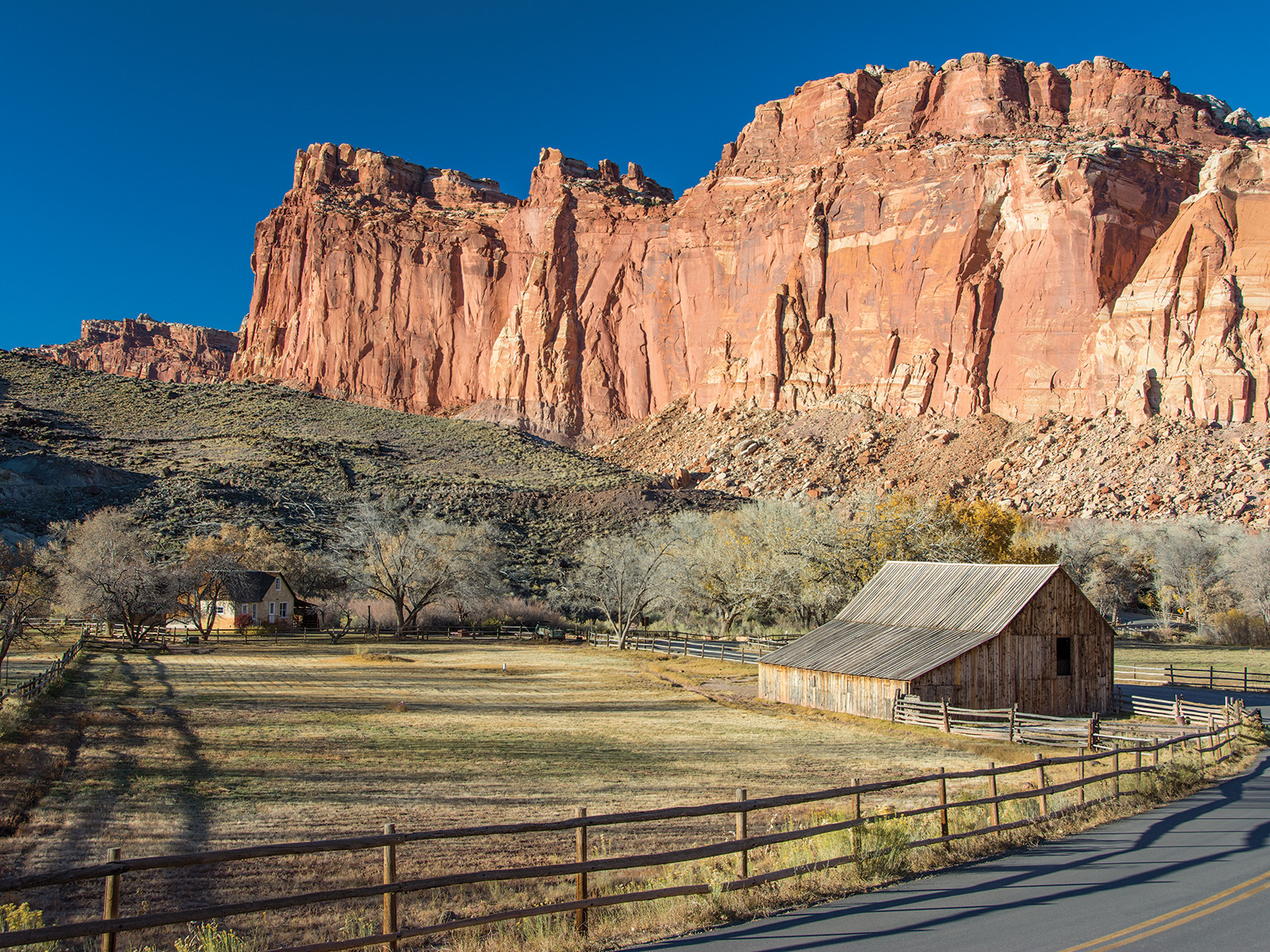
This is where almost everyone goes. The main visitor center, the historic Fruita settlement, the campground, and the most accessible trails all cluster along a 10-mile stretch of UT-24. The Scenic Drive begins here - an 8-mile paved road that branches south from the highway into the heart of the Waterpocket Fold. This district feels like a small-town park crossed with a working historic farm. The Fremont River runs through it, and the orchards planted by Mormon settlers in the 1880s still produce cherries, apricots, peaches, pears, and apples.
The Cathedral District (Notom-Bullfrog Road)
South of the Fruita area, the park narrows into a long corridor following the east side of the Waterpocket Fold. The Notom-Bullfrog Road runs 51 miles of mostly dirt track along the fold's eastern edge, connecting to the Burr Trail Road and eventually Lake Powell. This is where the crowds thin to near-zero. You'll share the road with cattle and the occasional backcountry hiker.
The Waterpocket District (South End)
The southern third of the park sees the fewest visitors by a wide margin. Access requires high-clearance vehicles on unmaintained roads. The reward: solitude measured in days, not hours, and some of the most dramatic slot canyons in the Colorado Plateau.
Getting around takes planning. The main visitor center to the Cathedral District turnoff is a solid 30 minutes. Add another 45 on dirt to reach the Burr Trail switchbacks. The southern end? Figure two to three hours from the visitor center, and that's if the roads are dry.
Planning Your Visit
Entrance Fees (as of 2026)
- Private vehicle: $20.00, valid for 7 days
- Motorcycle: $15.00, valid for 7 days
- Per person (bicyclists, pedestrians): $10.00
- America the Beautiful passes accepted and cover the pass holder plus three adults in a private vehicle
The park is open 24 hours a day, every day of the year. The visitor center hours vary by season - call 435-425-3791 for current times. It closes on Thanksgiving, Christmas, and New Year's Day.
When to Go
The park operates year-round, but conditions vary dramatically. June through September brings consistent heat - daytime temperatures regularly exceed 95°F in the Fruita area. September and October offer the best balance: comfortable hiking weather, fall colors in the orchards, and the harvest season for fruit picking.
Spring (March through May) works well for wildflowers and moderate temperatures, but expect rain and occasional road closures from snowmelt. Winter (December through February) means cold - daytime highs in the 30s and 40s - and snow that can make the Scenic Drive and dirt roads impassable. The crowds disappear entirely, which some visitors consider worth the cold.
Permits and Reservations
No reservations are needed for day use. The Fruita Campground operates on a first-come, first-served basis and fills daily from March through October. Backcountry permits are required for overnight trips and can be obtained at the visitor center up to 24 hours in advance. No online reservation system exists for backcountry permits - you must appear in person.
Special Use Permits are required for groups of 40 or more, organized trips by scouting groups, churches, or academic institutions, commercial photography, weddings, and first amendment activities. Apply well in advance.

Getting There & Getting Around
By Car
From I-70: Take exit 149, follow UT-24 west toward Hanksville for 43.8 miles, then continue on UT-24 west for another 37.3 miles. Total from the interstate: about 80 miles.
From I-15: Take exit 188, follow US-50 east toward Scipio, turn onto UT-50, then UT-260 south, then UT-24 east for 71.3 miles. This route passes through Torrey, the closest gateway town.
From UT-12: Head north on Highway 12 to Torrey, then turn right onto UT-24.
The nearest major airport is Salt Lake City International (SLC), about 3.5 hours north. Regional airports at Cedar City and Moab are closer but have limited service.
Parking Reality
The main parking lot at the visitor center fills by 10 AM in peak season. The overflow lot near the Fruita Campground is the backup. The Scenic Drive has limited pullouts - if the parking at the trailheads is full, you're waiting for someone to leave. Rangers will tell you that arriving before 8 AM solves most parking problems.
Cell Service
Cell service drops out about 2 miles in any direction from the visitor center. AT&T and Verizon have spotty coverage in the Fruita area. Nothing works once you enter the Scenic Drive or any dirt road. Download maps and information before you arrive.
The Scenic Drive
This 8-mile paved road is the park's main artery. It costs an additional $5 beyond the entrance fee (or is included with the America the Beautiful pass). The road ends at Capitol Gorge, where the pavement gives way to a dirt track suitable for passenger cars in dry conditions. The drive takes about 45 minutes one way without stops, but plan for 2-3 hours if you're hiking any of the side trails.
What to Do
Hiking
This is the primary activity for most visitors, and for good reason. The park offers everything from 15-minute walks to the historic Fruita schoolhouse to multi-day backpacking routes through the Waterpocket Fold's backcountry. The trails here tend to be less maintained and less signed than in Zion or Bryce - route-finding skills help on anything beyond the front-country paths.
The Cohab Canyon Trail, accessed from the Fruita area, climbs 400 feet to a hidden canyon with views across the valley. The Hickman Bridge Trail, a 1.7-mile round trip, leads to a natural bridge spanning 133 feet. The Cassidy Arch Trail, 3.4 miles round trip with 1,200 feet of elevation gain, ends at an arch named for the outlaw Butch Cassidy, who reportedly hid in these canyons.
For detailed route descriptions and difficulty ratings, see our guide to hiking at capitol reef national park.
Canyoneering and Climbing
The Waterpocket Fold contains some of the most technical slot canyons in Utah. The heads of Fivemile Wash and Burro Wash are closed through August 31, 2026, to protect sensitive resources - check current conditions before planning any canyon trip. Technical climbing requires a permit for overnight trips below the rim.
Scenic Driving
Beyond the main Scenic Drive, the Burr Trail Road offers a 66-mile route from Boulder to the Notom-Bullfrog Road, with a dramatic set of switchbacks carved into the Waterpocket Fold. This road is paved on the west side, dirt on the east. After rain, the dirt sections can become impassable even for high-clearance vehicles.
Ranger Programs and Cultural Demonstrations
The park offers Junior Ranger programs, guided walks, and evening programs at the amphitheater during peak season. The Fruita Historic District includes a schoolhouse, the Gifford Homestead (which sells fresh-baked pies in season), and the remains of the Mormon settlement that gave the area its name.
Stargazing
Capitol Reef is an International Dark Sky Park. The night sky here is genuinely dark - you can see the Milky Way as a defined structure, not a faint haze. The best viewing is from the Fruita area or along the Scenic Drive after dark.
Wildlife Watching
Mule deer are common in the Fruita area, especially at dawn and dusk. Desert bighorn sheep inhabit the more remote canyons. Bird species include peregrine falcons, golden eagles, and the occasional California condor - though sightings are rare. For species-specific tips and the best viewing locations, see our wildlife viewing guide.
Biking
The Scenic Drive is popular with road cyclists, especially during the Reef Ride Bike Days on September 19 and September 26, 2026, when the road closes to vehicles from sunrise to 3 PM. Mountain bikers can explore the Cathedral Valley and Burr Trail roads, but expect rough surfaces and no services.

Where to Stay
Inside the Park
The Fruita Campground is the only developed campground inside the park. It has 71 sites, no hookups, and operates first-come, first-served. It fills by early afternoon from March through October. The sites are spacious and shaded by cottonwoods, with flush toilets and drinking water available.
The Cedar Mesa Campground, 23 miles south on the Notom-Bullfrog Road, has 5 primitive sites with no water. It rarely fills completely.
Gateway Communities
Torrey, Utah, sits 11 miles west of the visitor center on UT-24. It has motels, inns, and a handful of restaurants. Book lodging here months in advance for summer visits. For a full breakdown of options, see our guide to lodging and accommodations near the park.
Camping Near Capitol Reef
The Dixie National Forest surrounds the park on the west side and offers dispersed camping at no cost. The BLM land east of the park also allows primitive camping. None of these sites have water or facilities. For detailed information on both developed and dispersed sites, check our camping options guide.
Seasonal Guide
Spring (March-May)
Temperatures range from 40°F to 75°F. The orchards bloom in April - apricot and peach blossoms against red rock make for strong photography. Rain is common, and the dirt roads can become impassable for days at a time. The Scenic Drive is usually fine, but call ahead for conditions on the Notom-Bullfrog and Burr Trail roads.
Summer (June-August)
Heat is the defining feature. Daytime highs exceed 95°F regularly, and the exposed trails become dangerous by mid-morning. Hike early - start before 7 AM and finish by noon. The crowds peak in July and August, but "peak" at Capitol Reef means something different than at Zion or Arches. You'll still find solitude on any trail longer than 2 miles.
Fall (September-October)
The best season. Temperatures range from 50°F to 80°F. The orchards open for fruit picking - check at the visitor center for what's ripe. The cottonwoods along the Fremont River turn gold in October. Crowds are moderate, and the light stays good for photography through late afternoon.
Winter (November-February)
Cold and quiet. Daytime highs hover in the 30s and 40s. Snow dusts the red rock and makes for striking contrasts. The Fruita Campground remains open but the water is turned off. The Scenic Drive may close after snow. Most visitors who come in winter are photographers and serious hikers willing to deal with cold for the solitude.

Practical Takeaways
- The fruit picking is not a gimmick. The historic orchards in Fruita are maintained by the park service and open to visitors when fruit is ripe. You pay a small fee per pound at the self-serve station. The apricots in July are worth timing a trip around.
- The Capitol Gorge Trail is the most underrated easy hike in the park. It follows an old wagon road through a narrow canyon, with pioneer names carved into the rock walls from the 1880s. It's flat, shady, and takes about an hour round trip.
- The park website doesn't emphasize that the Scenic Drive has a separate fee. It costs $5 beyond the entrance fee, though America the Beautiful pass holders don't pay extra. Bring cash - the pay station at the drive entrance doesn't always have reliable card service.
- Most visitors underestimate how far apart things are. The drive from the visitor center to the Burr Trail switchbacks is over an hour on dirt. Plan your day around driving time, not just hiking time.
- The temple of the Sun and Moon require high clearance. These Cathedral Valley formations are the most photographed features in the park's northern section, but the road to reach them is rough. Don't attempt it in a sedan unless conditions have been dry for at least a week.
- The trail register at the Chimney Rock trailhead has comments from people who underestimated the elevation gain. It's 2.5 miles with 1,200 feet of climbing in full sun. Rangers will tell you to carry a gallon of water per person for this one.
- The Gifford Homestead sells pies, but they sell out. The fruit pies (cherry, apple, peach) come out of the oven around 10 AM and are gone by early afternoon in summer. Get there early or accept disappointment.
- The best view of the Waterpocket Fold is from the east side. The Panorama Point overlook gives you the classic postcard perspective, but the view from the Burr Trail Road looking west across the fold shows its true scale - a 100-mile-long geologic wrinkle visible as a single continuous feature.
- Cell service drops out at the visitor center parking lot. Not "gets spotty" - drops out. Download maps, podcasts, and anything else you need before you leave Torrey.
- The park is open 24 hours, and the night sky is worth staying up for. The Milky Way is visible as a defined structure on moonless nights. The best viewing is from the amphitheater field or along the Scenic Drive after the gates open for overnight access.
Final Thoughts
Capitol Reef is the Utah national park that rewards patience. It doesn't announce itself the way Zion's canyon walls or Arches' delicate formations do. The Waterpocket Fold is a subtle feature - you need to stand at the right angle, at the right time of day, to see the scale of what's happening in the geology.
The park is made for visitors who want to slow down. The trails are less crowded, the distances between viewpoints are longer, and the rewards come from spending time rather than checking boxes. It asks you to carry your own water, read the weather forecast before entering a slot canyon, and accept that some roads will be impassable when you arrive.
What it gives back is a version of the Utah canyon country that most tourists never see: quiet enough to hear your own footsteps on the trail, dark enough to see the Milky Way as a physical presence, and strange enough - with its orchards and pioneer homesteads and 100-mile geologic fold - to make you wonder why you hadn't come sooner.
For help timing your trip around weather and crowds, see our guide to the best time to visit. For organized outings that cover the park's highlights, check our recommendations for tours and guided experiences.
For more information, see our complete National Park Guide.
Recommended Gear
What experienced visitors bring to Capitol Reef National Park: The Wrinkle in the Earth - Complete 2026 Guide
Links may earn us a commission at no extra cost to you. We only recommend gear we believe in.
Hiking Essentials
Hydration Pack (3L)
Hands-free water for long trail days
Trekking Poles (Pair)
Save your knees on steep descents
Hiking Boots (Ankle Support)
Sturdy footwear for rocky, uneven trails
Sun & Heat Protection
Wide-Brim Sun Hat
Full coverage UPF 50+ protection at altitude
Insulated Water Bottle (32oz)
Keeps water cold in desert heat all day
Winter Gear
Microspikes / Traction Devices
Essential for icy rim trails in winter months
Packable Down Jacket
Lightweight warmth that stuffs into a pocket
Sources
- Official source: NPS — Capitol Reef National Park nps.gov/care/index.htm
Explore More National Parks

Bryce Canyon National Park: Hoodoos, Stargazing & Complete 2026 Guide
Bryce Canyon National Park: Hoodoos, Stargazing & Complete 2026 Guide Overview Figuring out where to...

Canyonlands National Park: Utah's Wildest Canyon Country - 2026 Guide
Canyonlands has zero restaurants inside the park. 2026 guide to where to eat near each of its three...

Fly to Arches National Park: Nearest Airports & Tips (2026)
Discover where to fly to visit arches national park with our comprehensive guide. Expert tips, pract...

Zion National Park: Canyons, Angels Landing & Complete 2026 Guide
Discover slot canyons, Angels Landing, and red rock wilderness. Complete 2026 guide to Zion National...
Photo Gallery
More to Explore

Park Guide
Acadia National Park: Carriage Roads, Cadillac Mountain & 2026 Guide
Discover carriage roads, Cadillac Mountain, and rugged Maine coast. Complete 2026 guide to Acadia National Park — trails, fees, lodging, permits, and what rangers recommend.

Hiking Guide
Grand Canyon Hiking Trails: Day Hikes, Water Sources & Rim to Rim
Compare Grand Canyon hiking trails: Bright Angel, South Kaibab, Hermit, Grandview, and rim to rim, with distances, elevation, water stops, and trailhead access for each.

Best Of
Best of Glacier Bay National Park
The best of Glacier Bay is reached by boat: ranger-led day tours up the bay to the tidewater glaciers. What's worth it, how to book, and when to go (2026).

Campsite Guide
White Sands Backcountry Camping: Closed for 2026 — What to Know
As of 2026, backcountry camping at White Sands National Park is closed for site rehabilitation. What that means, and where to camp nearby instead.

Weather Guide
Guadalupe Mountains National Park Weather: Weather
Guadalupe Mountains National Park: weather guide guide updated 2026. Practical visitor information, reservations, and seasonal tips worth bookmarking before

Best Of
Best of Cuyahoga Valley National Park: Best Things to Do
Seeing a Cleveland Orchestra concert with the woods as your backdrop is a uniquely Cuyahoga Valley experience.
Sign in to join the conversation.
Sources & Attribution
Location data courtesy of the National Park Service (U.S. Department of the Interior). NPS data is public domain. Official NPS page.
Images: NPS; NPS; NPS; NPS; NPS.
Map data © OpenStreetMap contributors.
Park operations alerts: NPS.gov · Weather and weather hazards: National Weather Service · Live conditions.
Information may change. Always verify fees, hours, and conditions directly with the official source before visiting.
Did this guide help? Share it with a friend.