The Green and Colorado rivers don't just run through Canyonlands National Park - they carved it, splitting 337,598 acres of Utah desert into three distinct districts that feel like entirely different parks. Island in the Sky sits on a high mesa 40 minutes from Moab. The Needles sprawls southeast, an hour from Monticello. The Maze, to the west, requires 46 miles of dirt road and a high-clearance 4WD just to reach the ranger station. Most visitors never see all three in one trip. They shouldn't try to.
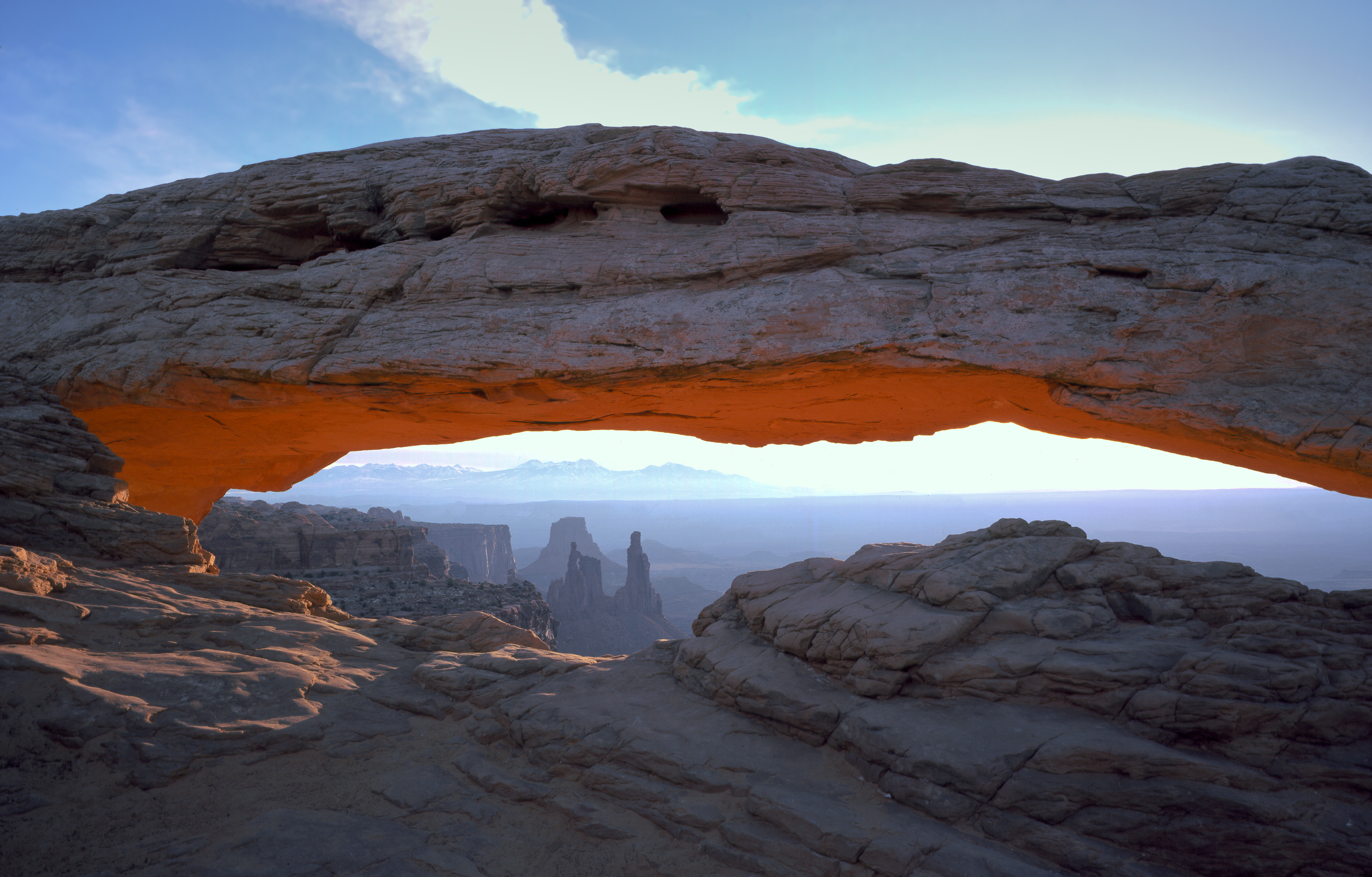
NPS via NPS.gov (Public Domain)
Canyonlands National Park: Utah's Wildest Canyon Country - 2026 Guide
16 min read
Places & Points of Interest
Canyonlands has zero restaurants inside the park. 2026 guide to where to eat near each of its three distinct districts, from Moab to Monticello.
Your plans
Where you eat near Canyonlands depends on which district you're visiting. The park has no restaurants, gas stations, or stores—nothing past the entrance stations except vault toilets, trail registers, and quiet. Moab serves Island in the Sky. Monticello and Blanding cover The Needles. Heading into The Maze? Pack every scrap of food before you leave pavement.
Don't show up and try to figure it out over lunch. Plan ahead—water jugs in the back seat, a cooler full of sandwiches. The nearest hot meal is 40 minutes to two hours away, depending on where you're standing.
Quick Information
- Entrance Fee: $30 per private vehicle (7 days), $25 per motorcycle, $15 per pedestrian or cyclist. Youth 15 and under enter free. America the Beautiful passes accepted.
- Hours: Open 24 hours a day, year-round. Entrance stations have variable staffing hours - check the NPS page for current times.
- Best Time to Visit: April-May and mid-September-October, when daytime highs sit 60-80°F and lows stay above freezing.
- Location: Southeastern Utah. Island in the Sky is 33 miles from Moab via UT 313. The Needles is 90 minutes from Moab via UT 211. The Maze is west of UT 24 near Hanksville.
- Accessibility: Island in the Sky Visitor Center and Grand View Point Overlook are wheelchair accessible. Most trails are not.
- Cell Service: Drops out completely within a few miles of either entrance station. Do not rely on having a signal.
- Restrooms: Flush toilets at Island in the Sky Visitor Center and The Needles Visitor Center. Vault toilets at trailheads and overlooks. No running water past the visitor centers.
- Parking: Main overlook lots fill by 10 AM in spring and fall. The Grand View Point lot is the worst offender. Rangers will tell you to come back later rather than park on vegetation.
Getting There
Island in the Sky is the district most first-time visitors head to, and for good reason - it's the easiest to reach and the most dramatic from a windshield. From Moab, take US 191 north for 10 miles, then turn left onto UT 313. Stay on 313 for 22 miles. The entrance station appears on your right. Total drive time: about 40 minutes from downtown Moab.
The Needles requires more commitment. From Moab, take US 191 south for 40 miles, then turn right onto UT 211. Follow UT 211 for 35 miles to the entrance station. From Monticello, it's about an hour straight west on UT 211. The road is paved the entire way, but the last few miles wind through ranchland where cattle occasionally wander onto the asphalt.
The Maze is a different category entirely. From UT 24 near Hanksville, turn onto the Flint Trail Road (dirt). The ranger station is 46 miles down this road. High-clearance 4WD is required - not recommended, required. The park service is not joking about this. Rental car companies in Moab will void your contract if you take their vehicles on this road.
Cataract Canyon boaters need to pay attention to current conditions. As of 2026, the Hite Ramp is closed. The primitive dirt take-out at North Wash is undergoing construction that can cause delays of up to 5 hours. Boaters are advised to use the foot trail past Highway 95 for passenger and gear drop-off, or plan their take-out at Bullfrog instead.

What to Expect
Canyonlands is high desert, sitting on the Colorado Plateau at elevations ranging from 3,700 feet along the rivers to over 6,000 feet at Island in the Sky. What that means in practical terms: you can wake up to frost in April and hit 90°F by mid-afternoon. Temperature swings of 40 degrees in a single day are normal. The air is dry enough that sweat evaporates before you notice it's there.
The sound profile here matters. On Island in the Sky, wind is the constant - it moves across the mesa top with nothing to break it, rattling through juniper and pinyon pine. Stand at any overlook and the only human sounds are the crunch of boots on sandstone and the distant conversation of people a quarter mile away. In The Needles, the wind sounds different - it funnels through the narrow canyons and red rock spires, creating a low hum that comes and goes. At night, in either district, the silence is the kind that makes you notice your own heartbeat.
The ground underfoot varies by location. Island in the Sky is mostly packed red dirt and slickrock - the sandstone is Navajo Sandstone in places, Wingate in others, and it shifts from grippy to slippery depending on whether it's dry or has overnight moisture. The Needles has more exposed rock, including the distinctive Cedar Mesa Sandstone that forms the park's namesake spires. On trails, you'll walk on everything from hard-packed gravel to loose sand that shifts with every step.
Wildlife is present but not pushy. Mule deer appear at dawn near the visitor centers. Desert bighorn sheep use the steep canyon walls in The Needles - look for them on the lower sections of the joint trails. Ravens are everywhere, and they're smart enough to know that unattended backpacks sometimes contain food. Collared lizards, the ones with the bright blue-green bodies, sun themselves on rocks along the Mesa Arch trail in the mornings. You'll see them before you hear them.
Top Attractions & Points of Interest
Mesa Arch
The most photographed spot in the park, and for good reason. This pothole arch sits right on the edge of a sheer drop, framing the La Sal Mountains in the distance through its opening. Sunrise is the draw - the underside of the arch glows orange as the sun comes up behind it, and the light catches the Colorado Plateau stretching east.
The trail to reach it is 0.5 miles round trip on flat slickrock. Easy. The parking lot, however, is not easy - it fills by 6:30 AM in spring and fall. Rangers will tell you to arrive by 5:30 AM if you want a spot. The sunrise show lasts about 15 minutes, then most people leave, and the lot empties out by 8 AM.
Grand View Point Overlook
The southern tip of Island in the Sky, 2 miles past Mesa Arch on the main road. From this overlook you can see the confluence of the Green and Colorado rivers - though at this distance they look like thin green-brown threads 2,000 feet below. The view stretches south across The Needles district and east to the La Sal Mountains. On clear days you can pick out the Abajo Mountains near Monticello.
The paved path to the viewpoint is wheelchair accessible and about 100 yards from the parking lot. There's also a 2-mile round trip rim trail that follows the edge south for better angles. The elevation gain is worth it - the views from the far end are better than the official overlook, and there are fewer people.
The Needles District Scenic Drive
A 10-mile paved road that dead-ends at Big Spring Canyon Overlook. The road passes by most of the district's major trailheads - Cave Spring, Pothole Point, Slickhorn, and the Big Spring Canyon overlook itself. The rock formations here are different from Island in the Sky: instead of a flat mesa top, you're driving through a landscape of red and white banded spires, some of which rise 200 feet straight up from the canyon floor.
The road is narrow in places, with pullouts for passing. RVs over 28 feet are not recommended. The drive itself takes about 30 minutes without stops, but most visitors spend 2-3 hours stopping at pullouts and walking the short trails.
Cave Spring Trail
A 0.6-mile loop in The Needles that combines three things: a historic cowboy camp, a short ladder climb, and a genuine spring seeping from the rock. The camp includes a restored cabin with period furniture, a corral, and a spring that still runs. The trail passes through a shallow cave and uses two metal ladders to navigate the slickrock sections.
The ladders are stable but narrow. If you're uneasy with heights, the ladders are only about 15 feet each, and the footholds are solid. Kids tend to love this trail. It's one of the few in the park that combines cultural history with geology in a short walk.
Upheaval Dome
A 3-mile round trip hike on Island in the Sky to a viewpoint overlooking a massive crater-like depression in the earth. Geologists disagree on whether Upheaval Dome is a meteorite impact site or a salt dome collapse - the park service literature hedges and says "scientists are still debating." Either way, it's a 5-mile-wide bowl of jumbled rock that looks nothing like the surrounding landscape.
The trail starts at the Upheaval Dome parking lot, about 10 miles down the main road. The first overlook is 0.8 miles in, and the second is 1.5 miles. The second viewpoint is better - from this overlook you can see the full scale of the structure, with the Green River visible in the distance. Pack extra water for this stretch. There's no shade past the first half mile.
Confluence Overlook (The Needles)
A 10.2-mile round trip hike in The Needles that ends at a viewpoint overlooking the meeting of the Green and Colorado rivers. This is the only place in the park where you can see both rivers from a single spot - the Green comes from the north, the Colorado from the east, and they merge in a swirl of green-brown water 1,000 feet below.
The trail is long but mostly flat, following an old jeep road through open country. The last mile crosses exposed slickrock with no shade. Start early - 6 AM is reasonable in summer. Bring at least 3 liters of water per person. The payoff is worth it, but the hike back in the afternoon heat is serious.

Activities
Hiking
The best hiking in Canyonlands National Park ranges from 0.2-mile wheelchair-accessible paths to multi-day backpacking routes. Island in the Sky has the highest concentration of short, rewarding trails - the Lathrop Trail drops 1,500 feet in under 3 miles and is the only maintained route from the mesa top to the White Rim. The Needles has longer, more remote trails that require route-finding skills. The Maze has no maintained trails at all - you navigate by cairn and topo map.
For first-time visitors, the best hike Canyonlands National Park offers depends on your time and tolerance for exposure. Mesa Arch (0.5 miles) and Grand View Point (2 miles) are the standard recommendations. If you want something that feels like an accomplishment without an overnight commitment, the Syncline Loop around Upheaval Dome is 8.3 miles with 1,500 feet of elevation gain and takes most people 5-7 hours.
For a comprehensive look at what's available, check the full guide to hiking trails in Canyonlands.
Stargazing
Canyonlands is an International Dark Sky Park. On moonless nights, the Milky Way is visible as a distinct band of light from any overlook. The best spots are Grand View Point and the Needles Visitor Center parking lot - both have wide horizons and no artificial light within miles.
The park hosts occasional astronomy programs in summer. Check at the visitor centers for schedules. Bring a red-light headlamp - white light ruins night vision for everyone, and the rangers will ask you to turn it off.
White Rim Road
A 100-mile dirt road that circles the Island in the Sky district at the base of the mesa. It's popular with mountain bikers and 4WD vehicles. The road requires high clearance and is not suitable for passenger cars. Bikers typically take 3-4 days to complete the loop, camping at designated sites along the route.
Permits are required for overnight use and are issued through a lottery system. Day-use permits for vehicle travel are available at the visitor center. The road is impassable when wet, and afternoon thunderstorms in summer can turn the clay sections into a slick, sticky mess.
Boating and Rafting
The Colorado and Green rivers offer some of the best whitewater in the West, particularly through Cataract Canyon below the confluence. Commercial trips run from Moab through the park. Private boaters need a permit and must be prepared for Class III-IV rapids depending on water levels.
As noted in current alerts, the Hite Ramp is closed as of 2026. Boaters taking out at North Wash should expect construction delays of up to 5 hours. Check with the park service for the latest conditions before launching.
Wildlife Viewing
Mule deer are common in the early morning around the visitor centers. Desert bighorn sheep are less common but reliably spotted in The Needles on the Confluence Overlook trail and the lower sections of the joint trails. Golden eagles nest on the cliff faces of Island in the Sky - look for them circling above the rim in late morning when thermals start rising.
A dedicated guide to wildlife viewing in the park is in development for more detailed species information.
Seasonal Guide
Spring (March-May): The busiest season for good reason. Daytime highs range from 50°F in March to 80°F in May. Wildflowers bloom in April - Indian paintbrush, lupine, and evening primrose appear along the mesa edges. Crowds peak in April during spring break. Entrance station wait times can exceed 30 minutes on weekends.
Summer (June-August): Hottest months. Daytime highs regularly exceed 100°F in July and August. Hiking is best done before 9 AM or after 5 PM. Afternoon thunderstorms are common in July and August - lightning on the exposed mesa tops is a real danger. Get off the high points by early afternoon. Crowds are lighter than spring but still present.
Fall (September-November): Second busiest season. September is ideal - highs in the 70s and 80s, clear skies, and fewer people than April. October brings cooler weather and the possibility of snow by late in the month. The cottonwoods along the rivers turn yellow in October, visible from the overlooks.
Winter (December-February): Cold and quiet. Daytime highs average 30-50°F. Nighttime lows drop to 0-20°F. Snow is possible but usually melts within a day on the mesa tops. The Needles district gets less snow than Island in the Sky. Trails can be icy in the mornings. The crowds are gone - you'll have most overlooks to yourself. Some facilities operate on reduced hours.
For a deeper breakdown of timing, see the guide to the best time to visit Canyonlands.

Practical Information
Fees
As of 2026, the entrance fee is $30 for a private vehicle (valid 7 days), $25 for a motorcycle, and $15 for pedestrians and cyclists. The America the Beautiful Annual Pass covers entry and is good value if you're visiting multiple parks.
Camping
Island in the Sky has one developed campground: Willow Flat, with 12 sites. First-come, first-served only. No reservations. Sites fill by noon in spring and fall. The Needles has a larger campground with 26 sites, also first-come, first-served. Both campgrounds have vault toilets but no showers or hookups. The Squaw Flat Campground in The Needles is the better option - more sites, more shade, and closer to trailheads.
Backcountry camping requires a permit, available at the visitor centers. Permits cost $36 per group plus a non-refundable $6 reservation fee. Walk-up permits are available, but popular routes book out weeks in advance in spring and fall.
For full details on sites and availability, see the complete guide to camping options in Canyonlands.
Lodging
There is no lodging inside the park. The nearest hotels are in Moab for Island in the Sky, and Monticello or Blanding for The Needles. Moab has the widest selection, from budget motels to higher-end hotels, but prices double during peak season (April-May and September-October). Book at least 3 months ahead for spring and fall visits.
For a full list of options outside the park, check the guide to lodging and accommodations near Canyonlands.
Where to Eat Near Canyonlands National Park
Where to eat near Canyonlands National Park depends entirely on which district you're visiting. There are zero restaurants inside the park boundaries. Plan accordingly.
For Island in the Sky visitors, Moab is the closest town with full dining options. The Moab Brewery on 400 West serves burgers, fish and chips, and house-brewed beers in a casual setting that's popular with returning visitors. The Jailhouse Cafe on 600 North is a breakfast spot that fills up fast - get there before 8 AM or expect a wait. For something faster, the Moab Diner on Main Street does breakfast all day and has a bakery case worth the stop.
For The Needles visitors, Monticello is the closest option with restaurants. The Peace Tree Juice Cafe on Main Street has sandwiches, smoothies, and salads. The MD Ranch Cookhouse serves steak and comfort food. Blanding, 20 minutes south, has a few fast-food options and a grocery store.
For The Maze, there is nothing. The nearest gas station with food is in Hanksville, about an hour from the Maze ranger station on dirt roads. You will have every meal you eat in The Maze with you before you leave pavement. This is not negotiable.
Gear and Supplies
Moab has several outdoor gear stores, including Gearheads and Poison Spider Bicycles. Monticello has a smaller selection. The Needles Visitor Center sells basic camping supplies but no fuel canisters. Fill up on everything in Moab or Monticello before heading into the park.
For guided trips and ranger-led programs, see the options for tours and guided experiences in Canyonlands.
Safety & Preparation
Water is the critical resource. There are no water sources in the park that are safe to drink without treatment, and even treated water from backcountry sources requires iodine or a filter rated for viruses. The park service recommends carrying 1 gallon of water per person per day in summer. That's not an exaggeration - that's the minimum for a full day of hiking.
Heat management matters from May through September. Hike before 9 AM or after 5 PM. Wear a wide-brimmed hat and long sleeves. Eat salty snacks to replace electrolytes. If you stop sweating, you are in serious trouble - get to shade and drink water immediately.
Lightning is a real danger on the mesa tops during afternoon thunderstorms in July and August. If you hear thunder, you are close enough to be struck. Get off exposed ridges and out of open areas. Do not shelter under isolated trees or overhangs.
Navigation is harder than it looks. The trails in The Needles and The Maze cross slickrock that shows no trail tread. Cairns mark the route, but they can be hard to spot in low light or from a distance. Carry a map and know how to use it. Cell service drops out at the park boundary and does not return.
Flash flooding is possible in slot canyons during thunderstorms, even if the storm is miles away. Do not enter slot canyons if rain is forecast. Check the weather before you leave and again at the visitor center.
Emergency contact: The park dispatch center can be reached at 435-719-2313. Cell service does not work in most of the park, so carry a satellite communication device if you're heading into The Maze or doing a multi-day backcountry trip.

Insider Tips
- The Mesa Arch sunrise crowd is manageable if you arrive by 5:30 AM. If you show up at 6:15 AM, you'll be parking on the road and walking a quarter mile to the trailhead. The show is 15 minutes of good light, then the arch goes flat and everyone leaves. Stick around for 20 minutes after the light fades - the latecomers leave, and you'll have the arch to yourself.
- Grand View Point is better at sunset than sunrise. The sun rises behind the viewpoint, so the morning light is flat and harsh. Late afternoon light rakes across the canyon walls, picking out every ridge and butte. The parking lot is also much emptier in the evening.
- The Needles is quieter than Island in the Sky by a factor of about 10. On a spring weekend, Island in the Sky feels like a national park. The Needles, 90 minutes away, feels like a secret. If you have the time, skip Island in the Sky entirely and spend your days in The Needles.
- The Pothole Point Trail in The Needles is a 0.6-mile loop that most people skip because it looks flat and uninteresting. It's not. The trail crosses slickrock dotted with potholes that fill with rainwater, and those potholes contain tiny ecosystems - tadpole shrimp, fairy shrimp, and algae that survive months of dry conditions. Go in the morning after a rain for the best viewing.
- The visitor center sells ice cream. It's not great ice cream, but after a 5-hour hike in 90-degree heat, it's the best thing you've ever eaten. The line at the counter moves slowly, so grab a number and wait your turn.
- Most visitors underestimate the drive time between districts. Island in the Sky and The Needles are 90 minutes apart by paved road. If you're staying in Moab and want to see both, that's 3 hours of driving minimum, not including the time at each district. Pick one district per day.
- The park newspaper, the Canyonlands Guide, contains the most current information on trail conditions, road closures, and ranger programs. Pick one up at the entrance station. It's free, it's updated regularly, and it contains details that don't make it onto the website.
For more information, see our complete National Park Guide.
Sources
- Official source: NPS — Canyonlands National Park nps.gov/cany/index.htm
Photo Gallery
More to Explore

Park Guide
Acadia National Park: Carriage Roads, Cadillac Mountain & 2026 Guide
Discover carriage roads, Cadillac Mountain, and rugged Maine coast. Complete 2026 guide to Acadia National Park — trails, fees, lodging, permits, and what rangers recommend.

Hiking Guide
Grand Canyon Hiking Trails: Day Hikes, Water Sources & Rim to Rim
Compare Grand Canyon hiking trails: Bright Angel, South Kaibab, Hermit, Grandview, and rim to rim, with distances, elevation, water stops, and trailhead access for each.

Best Of
Best of Glacier Bay National Park
The best of Glacier Bay is reached by boat: ranger-led day tours up the bay to the tidewater glaciers. What's worth it, how to book, and when to go (2026).

Campsite Guide
White Sands Backcountry Camping: Closed for 2026 — What to Know
As of 2026, backcountry camping at White Sands National Park is closed for site rehabilitation. What that means, and where to camp nearby instead.

Weather Guide
Guadalupe Mountains National Park Weather: Weather
Guadalupe Mountains National Park: weather guide guide updated 2026. Practical visitor information, reservations, and seasonal tips worth bookmarking before

Best Of
Best of Cuyahoga Valley National Park: Best Things to Do
Seeing a Cleveland Orchestra concert with the woods as your backdrop is a uniquely Cuyahoga Valley experience.
Sign in to join the conversation.
Sources & Attribution
Location data courtesy of the National Park Service (U.S. Department of the Interior). NPS data is public domain. Official NPS page.
Images: NPS; NPS; NPS; NPS; NPS.
Map data © OpenStreetMap contributors.
Park operations alerts: NPS.gov · Weather and weather hazards: National Weather Service · Live conditions.
Information may change. Always verify fees, hours, and conditions directly with the official source before visiting.
Did this guide help? Share it with a friend.