For more, see hiking trails and camping options.
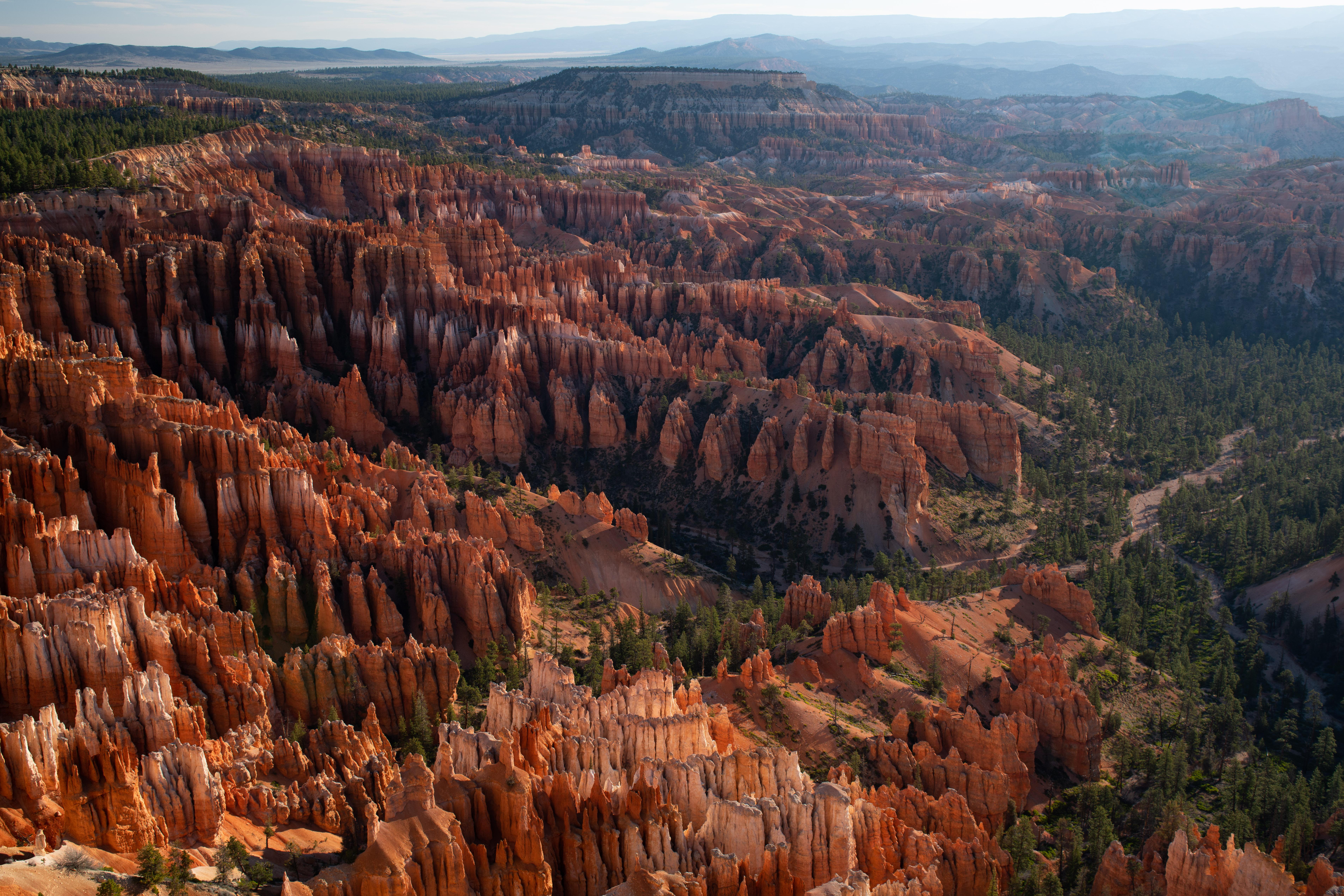
NPS Photo / Peter Densmore via NPS.gov (Public Domain)
Bryce Canyon National Park: Hoodoos, Stargazing & Complete 2026 Guide
13 min read
Places & Points of Interest
Learn where to park at Bryce Canyon before you arrive. The main lot fills by 9 AM in summer, so plan ahead to enjoy the hoodoos and 18-mile scenic road.
Your plans
Overview
Figuring out where to park at Bryce Canyon is the first puzzle most visitors face, and it's worth sorting out before you arrive. The main parking lot along the rim fills early - by 9 AM in summer, you'll be circling. But here's what first-timers don't realize: Bryce Canyon isn't a single canyon you drive into. It's a high plateau at the top of the Grand Staircase, and nearly everything you'll want to see sits along an 18-mile scenic road that runs south from the visitor center. Park strategically, and you'll skip the frustration.
Bryce Canyon holds the largest concentration of hoodoos - those irregular columns of rock - found anywhere on Earth. The high elevation climate means conditions shift fast: from October through May, temperatures fall below freezing nearly every night. Summer highs sit in the 70s and 80s Fahrenheit, with afternoon thunderstorms common in July and August. The park sits at over 8,000 feet in elevation, which affects everything from how far you can hike to whether your car will start on a cold morning. For anyone planning hiking trails, starting with a solid parking strategy makes the difference between a relaxed morning and a frustrating one.
Quick Information
- Entrance Fee: $35 per private vehicle (valid 7 days), $30 per motorcycle, $20 per person for walk-ins and bicyclists. Youth 15 and under enter free. Non-US residents pay an additional $100 fee unless they hold an America the Beautiful Pass or Annual Pass.
- Hours: Open 365 days a year, 24 hours a day.
- Best Time to Visit: May through September for trail access. Late September through October for fewer crowds and moderate temperatures. December through February for snowshoeing and solitude - but expect road closures after storms.
- Location: Highway 63, Bryce, Utah 84764. Approximately 80 miles northeast of Zion National Park.
- Accessibility: Rim Trail sections near the lodge and visitor center are paved and wheelchair-accessible. Many overlooks along the scenic drive have paved viewing areas.
- Cell Service: Drops out along most of the scenic drive and on trails. The visitor center area has the most reliable signal.
- Restrooms: Flush toilets at the visitor center, lodge, and Sunset Campground. Vault toilets at most overlooks along the scenic drive.
- Parking: Main lot near the visitor center fills first. Overflow lots at Sunset Campground and along the access road. The southern lots - Rainbow Point, Yovimpa Point, and Farview Point - rarely fill completely.

Getting There
From the north, take I-15 south to UT-20 (exit 95). Head east on UT-20 to US-89, then follow US-89 south to UT-12. Go east on UT-12 to UT-63, then take UT-63 south into the park. The drive from Salt Lake City runs about four hours.
From the south through Zion National Park, take I-15 north to UT-9 (exit 16). Follow UT-9 east through Zion to US-89, then north to UT-12. East on UT-12 to UT-63, then south into Bryce. This route from Zion takes roughly two hours - but add time for Zion traffic in summer.
From the east, take UT-12 west directly to UT-63. This route passes through Grand Staircase-Escalante National Monument and has some of the most scenic driving in the state.
The park has one entrance station, located just past the town of Bryce on UT-63. There's no back entrance. Everyone funnels through the same gate. If you arrive between 10 AM and 2 PM in summer, expect a 10- to 20-minute wait at the entrance booth.
As for where to park at Bryce Canyon, the main lot sits right past the entrance station and visitor center. It holds about 200 vehicles. When it fills, rangers direct traffic to overflow lots near Sunset Campground and along the access road. A shuttle runs from the overflow lots to the visitor center and lodge area, but it's about a half-mile walk if you prefer to skip the wait. The southern lots - Rainbow Point, Yovimpa Point, and the viewpoints along the scenic drive - almost always have space. If you're heading straight to the southern end of the park, drive past the crowded lots and park at Rainbow Point. You'll save time and start your visit from the quietest part of the park.
What to Expect
Bryce Canyon sits at 8,000 to 9,100 feet in elevation. If you're coming from sea level, you'll feel it. The air is thin, the sun burns faster than you expect, and walking uphill will leave you winded faster than you'd like. Rangers will tell you to drink twice as much water as you think you need - and they're not exaggerating.
The terrain is all about the hoodoos. From the rim, you look down into natural amphitheaters packed with thousands of these spires, fins, and pinnacles. The color shifts across the rock face - white, pink, red, orange - depending on the mineral content and the time of day. Early morning and late afternoon bring out the deepest reds. Midday light flattens everything into a pale orange.
The park's high elevation supports multiple life communities. Ponderosa pine and spruce-fir forests cover the plateau. Below the rim, you'll find manzanita, mountain mahogany, and pockets of wildflowers that peak in June and July. Wildlife is present but not as visible as in parks like Yellowstone or Grand Teton. Mule deer are common at dawn and dusk. Pronghorn graze in the open meadows near the entrance. Bird species include Steller's jays, Clark's nutcrackers, and the occasional peregrine falcon working the cliffs. Mountain lions exist in the park - tracks are spotted regularly - but actual sightings are rare.
The soundscape is quieter than most national parks. There's no river noise, no traffic roar from distant highways. What you hear is wind through pine needles, the crunch of your own footsteps on packed dirt, and ravens calling from somewhere below the rim. At night, the silence is deep enough that you notice your own breathing.
Most visitors underestimate how cold the park stays. Even in July, mornings start in the 40s. By October, daytime highs barely break 50°F, and snow can fall any month of the year. The park's coldest and snowiest period runs from December through February. Spring storms in March and April can still produce heavy snowfall that impacts travel.

Top Attractions & Points of Interest
Bryce Amphitheater
This is the park's centerpiece - a massive natural amphitheater visible from multiple overlooks along the rim. Sunrise Point, Sunset Point, Inspiration Point, and Bryce Point all face into the same formation from different angles. Early morning is your best bet for soft light and smaller crowds. From this overlook you can see the entire eastern sweep of the amphitheater, with the Navajo Loop and Queen's Garden trails descending into the hoodoos below.
Navajo Loop and Queen's Garden Trail
The most popular hiking route in the park, and for good reason. This 2.9-mile loop drops from Sunset Point into the heart of the amphitheater, passes through the famous Wall Street section (when it's open), and connects to Queen's Garden for the climb back up to Sunrise Point. The trail narrows here at several switchbacks, and the elevation change of 550 feet feels like more at 8,000 feet. The Wall Street side of Navajo Loop is currently closed due to hazardous conditions - check at the visitor center for updates. The trail is still accessible via the Queen's Garden side.
Inspiration Point
A short paved walk from the parking area leads to one of the broadest views of the amphitheater. The elevation gain is worth it - the view stretches south along the entire park escarpment. Three separate viewing platforms offer different angles. The upper platform requires climbing about 30 steps but provides the most complete panorama.
Rainbow Point
The southern terminus of the scenic drive, Rainbow Point sits at 9,115 feet - the highest point in the park accessible by vehicle. The parking lot here is small but rarely full because most visitors turn around at the overlooks closer to the entrance. The Bristlecone Loop Trail starts here, a flat one-mile walk through ancient bristlecone pines. These trees are among the oldest living things on the planet, with some exceeding 1,500 years.
Fairyland Point
Located north of the main amphitheater, Fairyland Point gets a fraction of the crowds. The Fairyland Loop Trail is 8 miles round-trip and strenuous, but the views are spectacular and you'll often have stretches of trail entirely to yourself. The parking lot here holds about 20 vehicles.
Mossy Cave Trail
A short, easy hike - about 0.8 miles round-trip - located just outside the park boundary on UT-12. It's not within the park proper, but it's managed by the park service and worth the stop. The trail follows a small stream and ends at a cave with, yes, moss on the walls. It's one of the few places in the park with running water visible year-round.
Activities
Hiking
The park has over 50 miles of trails, ranging from paved rim walks to strenuous backcountry routes. The most popular bryce canyon hiking trail combinations are the Navajo Loop and Queen's Garden loop (2.9 miles, moderate), the Rim Trail from Sunrise to Bryce Point (5.5 miles one-way, easy to moderate), and the Peekaboo Loop (4.9 miles, strenuous). For anyone looking at bryce canyon trails best suited to their ability, the Rim Trail offers the most accessible options with the least elevation change.
The bryce canyon navajo trail remains the park's signature hike. When conditions allow - and assuming the Wall Street side reopens - it's the route that drops you into the hoodoos and gives you the perspective you can't get from the rim. Check at the visitor center for the current status.
Trails in Bryce Canyon vary significantly in difficulty. The Bristlecone Loop at Rainbow Point is flat and paved. The Fairyland Loop is an all-day commitment with serious elevation gain. The Under-the-Rim Trail traverses 22 miles from Bryce Point to Rainbow Point and requires overnight permits for backpacking.
Stargazing and Astronomy
Bryce Canyon holds International Dark Sky Park status. The night sky here is extraordinary - the Milky Way is visible as a distinct band of light, not a faint haze. The park runs astronomy programs from May through September, including telescope nights at the visitor center and full-moon hikes. No special equipment needed, but a red-light headlamp helps preserve your night vision.
Cross-Country Skiing and Snowshoeing
From December through February, the park's roads and trails turn into winter routes. The scenic drive closes to vehicles past certain points, making it a groomed ski track. The Rim Trail is popular for snowshoeing. Rentals are available in the town of Bryce.
Wildlife Watching
Mule deer, pronghorn, and golden-mantled ground squirrels are the most commonly seen animals. Birdwatchers will find Steller's jays, Clark's nutcrackers, and on lucky days, peregrine falcons. The park's wildlife viewing is best at dawn and dusk, particularly along the park's meadows near the entrance and in the ponderosa pine forests.
Horseback Riding
Guided horse trips descend into the amphitheater from the lodge area. The rides last two to three hours and follow the Peekaboo Loop. Reservations are recommended in summer. Walking the trails after a horse group has passed means dealing with the smell and the mess - but the horses are a long tradition here and make the trail accessible to people who can't or shouldn't hike.
Camping
Two campgrounds operate within the park. Sunset Campground is open year-round and sits close to the amphitheater. North Campground is also open seasonally. Both offer tent and RV sites. No hookups are available at either location. For details on camping options, including reservation windows and site-specific info, check the park's camping page. Bryce Canyon camping near the park also includes private campgrounds and RV parks in the town of Bryce and along UT-12.
Junior Ranger Program
Kids ages 4 through 12 can pick up a Junior Ranger booklet at the visitor center. Completing the activities - attending a ranger program, hiking a trail, answering questions about the park - earns them a badge. It's a well-designed program that actually teaches something.

Seasonal Guide
Spring (March through May)
Snow remains common through April. Daytime highs range from 40°F to 60°F. Nights stay below freezing. Some trails remain snow-packed into May. Crowds are light in March and April, picking up in May. The Navajo Loop might still have ice on the switchbacks. Microspikes are worth carrying.
Summer (June through August)
The busiest season. Daytime highs in the 70s and 80s. Afternoon thunderstorms are common in July and August - get off exposed ridges by early afternoon. Parking lots fill by 9 AM. Shuttle buses run from the visitor center to the main overlooks. Reservations for lodging and accommodations should be made months in advance. Sunrise and Sunset Points are shoulder-to-shoulder by 10 AM.
Fall (September through November)
The best season for hiking. Daytime temperatures in the 60s and 70s in September, dropping to the 40s and 50s by November. Crowds thin significantly after Labor Day. Aspen and oak turn gold and red in late September and early October. Storms in November can bring snow that closes sections of the scenic drive.
Winter (December through February)
Quietest time of year. Daytime highs in the 30s and 40s. Nights drop well below freezing. Snow accumulates on trails and roads. The scenic drive may close south of certain points depending on conditions. Cross-country skiing and snowshoeing replace hiking. The hoodoos look dramatically different under snow - worth seeing if you can handle the cold. The parking situation is the easiest of any season. You'll have most overlooks to yourself.
Practical Information
Fees
The standard entrance fee is $35 per private vehicle, valid for 7 days. Motorcycles pay $30. Walk-ins and bicyclists pay $20 per person. Youth 15 and under are free. Non-US residents aged 16 and older pay an additional $100 nonresident fee unless they have an Annual Pass or America the Beautiful Pass. If you're visiting multiple national parks in a year, the $80 America the Beautiful Pass covers entrance fees at all federal fee sites and waives the nonresident surcharge.
Campgrounds
Sunset Campground offers reservable sites from May through September, with first-come, first-served sites available in the off-season. North Campground has similar availability. Both have potable water, flush toilets (seasonally), and dump stations. No hookups. The maximum RV length is 40 feet, but larger RVs will struggle with the tight roads in the campground loops.
What to Bring
Water is the single most important item. There are no water sources on the trails. Bring at least one liter per hour of hiking. Sunscreen, sunglasses, and a hat are essential - UV exposure is significantly higher at 8,000 feet. Layers are non-negotiable. A 30°F temperature swing between the coldest and warmest part of the day is normal. Trekking poles help on steep descents, especially on the Navajo and Peekaboo loops.
Food and Supplies
The Bryce Canyon Lodge dining room serves breakfast, lunch, and dinner seasonally. The General Store near the lodge sells snacks, sandwiches, and basic supplies. The town of Bryce, just outside the park entrance, has a grocery store and several restaurants. Fill your gas tank before arriving - the nearest gas station is in Bryce, and the next one is 30 miles away in Tropic.

Safety & Preparation
Altitude affects everyone differently. Headache, fatigue, and shortness of breath are common at 8,000 feet if you arrive from low elevation. Plan an easy first day. Drink water. Avoid alcohol. If symptoms worsen - confusion, difficulty walking, chest tightness - descend immediately.
Lightning is a real threat in July and August. Afternoon thunderstorms build fast. If you hear thunder, you're close enough to be struck. Get off exposed ridges and away from solitary trees. The Rim Trail and viewpoints are particularly exposed. Start hikes early and plan to be back at the trailhead by 1 PM during monsoon season.
Trail conditions change rapidly. Snow and ice can linger on north-facing slopes into June. The Wall Street side of Navajo Loop is currently closed due to hazardous conditions. Check at the visitor center before heading out. Pack extra water for this stretch - even moderate hikes feel harder at altitude.
Cell service drops out at the entrance station and does not return until you're back on UT-12. Download maps and directions before you arrive. The park's paper map, available at the entrance station, is more reliable than any phone.
Insider Tips
The parking trick for the amphitheater. Instead of fighting for a spot at Sunset or Sunrise Point, park at the visitor center and walk the Rim Trail. It's a flat, paved 0.5-mile walk along the rim directly to Sunset Point. You'll bypass the traffic and have a better view approach than coming up from the lot.
Arrive before 7 AM in summer. The main parking lot fills by 9 AM. If you roll in at 10, you'll spend 20 minutes circling. The overflow lots work, but they add a quarter-mile walk. Getting there early also means better light for photography and cooler hiking temperatures.
Rainbow Point parking is the backup plan. When all the northern lots are full, Rainbow Point and Yovimpa Point at the southern end of the scenic drive almost always have space. Drive the full 18 miles. You'll work backward through the viewpoints as you head north, but you'll avoid the crowds.
The shuttle is free and runs frequently. From May through September, the Bryce Canyon shuttle runs from the visitor center to the main overlooks and campgrounds. Parking at the visitor center and taking the shuttle is a better experience than trying to drive between viewpoints. The lot at the visitor center is larger than the overview lots and fills later.
Watch for snow in October. Heavy snowfall can close the scenic drive past certain points as early as mid-October. If you're visiting in fall, check the park's road conditions before heading south. The road crew is efficient - most closures last less than 24 hours - but plan accordingly.
The best time to visit for solitude is December. The park gets fewer than 10,000 visitors in December compared to over 200,000 in July. Snowshoe in, have the amphitheater to yourself, and understand why rangers who've worked here for twenty years still call it their favorite season.
Bring cash for the entrance fee. The entrance station accepts credit cards, but the cell signal for the card reader can be slow. Cash speeds everything up. Also, the bookstores and gift shops in the park operate on a separate system - they take cards fine, but the entrance station processes payments through a cellular connection that sometimes fails.
For more information, see our complete National Park Guide.
Related: bryce canyon hiking guide
Related: bryce canyon hiking trail guide
Sources
- Official source: National Park Service nps.gov/brca/index.htm
Photo Gallery
More to Explore

Park Guide
Acadia National Park: Carriage Roads, Cadillac Mountain & 2026 Guide
Discover carriage roads, Cadillac Mountain, and rugged Maine coast. Complete 2026 guide to Acadia National Park — trails, fees, lodging, permits, and what rangers recommend.

Hiking Guide
Grand Canyon Hiking Trails: Day Hikes, Water Sources & Rim to Rim
Compare Grand Canyon hiking trails: Bright Angel, South Kaibab, Hermit, Grandview, and rim to rim, with distances, elevation, water stops, and trailhead access for each.

Best Of
Best of Glacier Bay National Park
The best of Glacier Bay is reached by boat: ranger-led day tours up the bay to the tidewater glaciers. What's worth it, how to book, and when to go (2026).

Campsite Guide
White Sands Backcountry Camping: Closed for 2026 — What to Know
As of 2026, backcountry camping at White Sands National Park is closed for site rehabilitation. What that means, and where to camp nearby instead.

Weather Guide
Guadalupe Mountains National Park Weather: Weather
Guadalupe Mountains National Park: weather guide guide updated 2026. Practical visitor information, reservations, and seasonal tips worth bookmarking before

Best Of
Best of Cuyahoga Valley National Park: Best Things to Do
Seeing a Cleveland Orchestra concert with the woods as your backdrop is a uniquely Cuyahoga Valley experience.
Sign in to join the conversation.
Sources & Attribution
Location data courtesy of the National Park Service (U.S. Department of the Interior). NPS data is public domain. Official NPS page.
Images: NPS Photo / Peter Densmore; NPS Photo / Keith Moore; Derek Demeter; NPS Photo / Peter Densmore; NPS Photo / Peter Densmore.
Map data © OpenStreetMap contributors.
Park operations alerts: NPS.gov · Weather and weather hazards: National Weather Service · Live conditions.
Information may change. Always verify fees, hours, and conditions directly with the official source before visiting.
Did this guide help? Share it with a friend.