Best of Capitol Reef National Park: Best Stargazing in (2026)
11 min read
Best Of
Capitol Reef sits 90 miles from the nearest city, making its night sky one of the darkest in the lower 48. 2026 guide to planning your visit around sunset.
This article contains affiliate links — we may earn a small commission at no extra cost to you.
Advertisement
If You Only Have One Day
Capitol Reef stands apart from Utah's other parks for one reason: its best experience begins after dark. More than 90 miles from any sizable city, the park claims some of the darkest skies in the lower 48. If you have only one day, plan your schedule around sunset.
Arrive at the visitor center by 8:30 AM to grab a park newspaper and check the day's posted weather. Weather conditions change fast in the Waterpocket Fold, and that afternoon thunderstorm you ignored could close the dirt roads you planned to drive. Head straight for the Scenic Drive - it's a 25-mile round trip on paved road that gives you the quickest access to the park's core geology without requiring any hiking. Stop at every pullout. The road ends at Capitol Gorge, where a one-mile walk through a narrow canyon passes petroglyphs and the historic Pioneer Register.
By noon, you should have the Scenic Drive behind you. Grab lunch in Torrey (UT-24, five minutes west of the park entrance) - the park has no food services beyond snacks at the visitor center. Spend the afternoon on one solid hike. The Cassidy Arch Trail (3.4 miles round trip, 670 feet of elevation gain) delivers the best payoff for time invested, ending at an arch you can actually stand on top of. Most visitors underestimate the afternoon heat in summer months - pack extra water for this stretch.
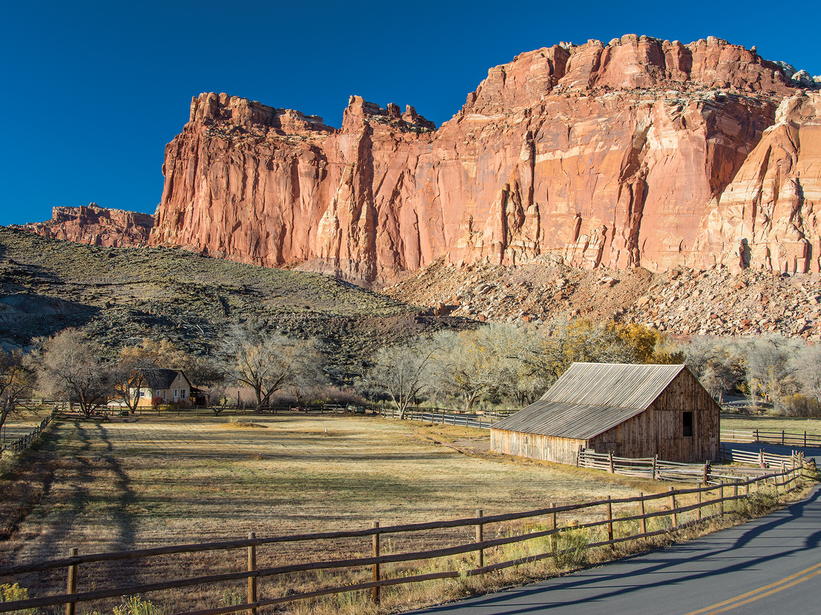
As sunset approaches, drive back toward the visitor center and turn onto the dirt road leading to the historic Fruita district. The one-way road along the Fremont River passes through orchards planted by Mormon settlers in the 1880s. Park near the old schoolhouse. This is where the night show begins.
Here's what most one-day visitors get wrong: they leave after sunset. Stay. The best stargazing in Capitol Reef National Park doesn't start until full astronomical darkness - roughly 90 minutes after the sun goes down. The Milky Way becomes visible as a distinct band of light, not a faint haze. Bring a chair. Bring layers. The temperature drops 30 degrees after dark even in July.
Photo: NPS via NPS.gov (Public Domain)
The Top Experiences, Ranked
#1 - Night Sky Viewing at the Fruita Orchards: The Undisputed Best Experience in the Park
Why it makes this list: Capitol Reef was designated an International Dark Sky Park in 2015, and the Fruita area offers the most accessible combination of dark skies and foreground interest. The old orchards and pioneer buildings sit in a valley surrounded by 1,000-foot cliffs, which block distant light pollution while framing the sky.
What it requires: No hiking. Drive to the Fruita district (3 miles east of the visitor center on UT-24, then turn south at the sign). Park at the first orchard pullout. You need a chair or blanket, warm clothes, and patience - your eyes take 30 minutes to fully adjust.
The single best tip: Visit during a new moon. The park's astronomy programs run from April through October, with ranger-led telescope nights on Saturdays in summer. Check the visitor center for the schedule. Without a ranger program, bring binoculars - even 10x42s will show you the Andromeda Galaxy as a fuzzy oval.
What most visitors do wrong: They look straight up. The best views are actually low on the southern horizon, where the Milky Way core rises over the Waterpocket Fold. Lie flat on your back and let your peripheral vision do the work.
#2 - Cassidy Arch Trail: The Best Hike for First-Timers
Why it makes this list: Most trails in Capitol Reef lead to a viewpoint looking at something. Cassidy Arch delivers the opposite - you walk onto the arch itself. Standing on a 200-foot-thick slab of Navajo Sandstone with a 400-foot drop on either side is a genuine adrenaline moment.
What it requires: 3.4 miles round trip, 670 feet of elevation gain. The trail is well-marked but steep in sections, with exposed slickrock that gets slippery after rain. Allow 2-3 hours.
The single best tip: Start by 8 AM in summer. The trail runs up a west-facing slope with zero shade. By 10 AM, the rock surface is radiating heat.
What most visitors do wrong: They stop at the first flat spot and photograph the arch from below. Keep going to the top of the arch. The trail continues across it and the view from the far side shows the entire Grand Wash canyon system.
#3 - The Scenic Drive: Maximum Geology, Minimum Effort
Why it makes this list: For anyone who can't hike or has limited time, this 25-mile round trip on paved road is the most efficient way to see the Waterpocket Fold. The road follows the fold's western edge for 8 miles, then drops into Capitol Gorge.
What it requires: 1-2 hours. A standard passenger vehicle can handle the paved section. The unpaved extension (Notom-Bullfrog Road) requires high clearance and dry conditions.
The single best tip: Go early. The parking situation here is limited at the gorge trailhead, and tour groups fill the pullouts by 10 AM.
What most visitors do wrong: They drive straight through without stopping. Each pullout shows a different aspect of the fold - the first three stops offer the best morning light for photography.
#4 - Hickman Bridge Trail: The Classic Family Hike
Why it makes this list: This 1.7-mile round trip hike with 400 feet of gain hits the sweet spot between effort and reward. The trail ends at a 133-foot natural bridge that you can walk under.
What it requires: About 90 minutes. Moderate grade, well-maintained trail. Suitable for most fitness levels.
The single best tip: The trailhead is on UT-24, 2 miles east of the visitor center. It has a small parking lot that fills by 9 AM in peak season. If the lot is full, come back after 2 PM.
What most visitors do wrong: They miss the side trail to the Fremont petroglyph panel. About 0.2 miles from the trailhead, a short spur leads to a cliff face covered in Barrier Canyon Style rock art. The figures are 1,000-2,000 years old.
#5 - Grand Wash: The Slot Canyon Experience Without the Danger
Why it makes this list: Grand Wash is a 2.5-mile (one way) box canyon with 800-foot vertical walls that narrow to 15 feet in places. Unlike slot canyons in other parks, it's wide enough to feel comfortable but narrow enough to feel dramatic. No technical skills required.
What it requires: 2-3 hours round trip. The trail is flat and sandy - no elevation gain. The road to the trailhead is unpaved but usually passable for passenger cars.
The single best tip: Check the weather before entering. The NPS warning about narrow canyons applies here specifically - flash floods can develop from storms 20 miles away. If there's any rain in the forecast, skip this hike.
What most visitors do wrong: They turn around at the narrowest section. Keep walking another half-mile to where the canyon opens into a natural amphitheater. The acoustics are remarkable.
#6 - The Historic Fruita District: More Than Just Apple Pie
Why it makes this list: The Mormon settlement that occupied this valley from 1880 to 1960 left behind orchards, a schoolhouse, and a blacksmith shop. The park service maintains the orchards as a living historical site - you can pick fruit in season for free.
What it requires: Walking only. The orchards are spread along a one-mile dirt road that's closed to vehicles but open to pedestrians and bikes.
The single best tip: Visit in September for the apple harvest. The orchards have 2,700 trees including apples, pears, peaches, and apricots. You're allowed to pick and eat whatever you can reach.
What most visitors do wrong: They skip the schoolhouse. The interior has been restored to its 1900s condition, and the interpretive signs explain what life was like for families who lived here year-round.
#7 - The Cathedral Valley Loop: For Those With High Clearance
Why it makes this list: This 58-mile dirt road loop crosses the northern section of the park through a landscape of sandstone monoliths that resemble Gothic cathedral spires. It's the most remote experience in the park.
What it requires: A high-clearance vehicle, ideally 4WD. The road crosses the Fremont River twice (no bridges) and includes several sandy sections. Allow 4-6 hours.
The single best tip: Check road conditions at the visitor center before attempting. Rain closes these roads completely. The clay-based soil turns into grease when wet and will coat your vehicle in red mud that takes hours to clean.
What most visitors do wrong: They underestimate the time. The loop is 58 miles but averages 10-15 mph. A flat tire here means waiting hours for help.
#8 - Sulphur Creek Route: The Advanced Canyon Hike
Why it makes this list: This 5.5-mile point-to-point route follows Sulphur Creek through a narrow canyon with five waterfalls, ending at the visitor center. It's the most adventurous day hike in the park.
What it requires: Route-finding skills, water shoes, and a willingness to get wet. The hike involves wading through knee-deep water and scrambling over boulders. Not suitable for beginners. You'll need to arrange a shuttle or leave a car at the end point.
The single best tip: Do this hike in late spring when the water is running but not dangerous. By August, the creek is often dry.
What most visitors do wrong: They underestimate the cold. The water comes from snowmelt and stays in the 50s even in July.
Photo: NPS via NPS.gov (Public Domain)
What Most People Miss
The Chimney Rock Petroglyph Panel. Most visitors drive right past it. The panel sits on a cliff face visible from UT-24, about 4 miles west of the visitor center. No trail required - pull over at the marked turnout and look up. The panel shows bighorn sheep, human figures, and geometric patterns carved by Fremont people between 600 and 1300 AD. The best viewing is late afternoon when the low sun casts shadows that make the carvings pop.
The Behunin Cabin. Tucked behind the visitor center, this one-room stone cabin was built in 1882 by Elijah Behunin, one of the first Mormon settlers in the valley. It's the oldest standing structure in the park. Most visitors walk past it on their way to the restroom. Stop and read the interpretive sign - the story of how Behunin built the cabin using local sandstone and juniper logs, living here with his wife and seven children, puts the entire park in context.
The night sky at the Goosenecks Overlook. While the Fruita orchards are the most popular stargazing spot, the Goosenecks Overlook (1.5 miles north of the visitor center on the dirt road) offers better horizon views. The overlook sits 800 feet above the Fremont River, and the lack of trees means you can see the sky from horizon to horizon. The Milky Way reflection off the river below is visible on moonless nights.
The petrified wood in the Muley Twist area. The park has significant deposits of petrified wood from the Chinle Formation, but most visitors never see it. The Muley Twist Canyon area (accessible via the Burr Trail Road) has exposed logs that show the full range of colors - reds, purples, yellows, and blacks. The park service asks visitors not to take samples, obviously, but the sight of a 30-foot-long log turned to stone is worth the drive.
The Pioneer Register in Capitol Gorge. At the end of the Scenic Drive, a short walk leads to a canyon wall covered in names carved by pioneers traveling through the gorge in the 1880s. The earliest date visible is 1881. It's not a petroglyph - it's actual graffiti from people who passed through this canyon when it was the main road through the region. The contrast between the ancient Fremont carvings elsewhere in the park and these 140-year-old names tells the whole story of human presence here.
Photo: NPS via NPS.gov (Public Domain)
What's Overrated (and Better Alternatives)
The Panorama Point overlook. It's the first stop most visitors make after entering the park, and it's fine - you can see the entire Waterpocket Fold from a single viewpoint. But the light is wrong for most of the day. The viewpoint faces east, so it's backlit from mid-morning onward. Better alternative: Skip it and drive to the Sunset Point overlook instead (0.5 miles further up the same road). It faces west and catches the evening light much better.
The full Scenic Drive in summer. The paved section is worth doing, but the unpaved extension (Notom-Bullfrog Road) is often underwhelming for the time investment. It's a slow, washboarded dirt road that takes 2-3 hours to drive and offers views that are only marginally better than what you see from the paved section. Better alternative: Drive the paved Scenic Drive to the Capitol Gorge trailhead, walk the gorge, then turn around. You'll see the best of the Waterpocket Fold in half the time.
The Hickman Bridge Trail at midday. This is the park's most popular hike, and for good reason. But at noon in summer, the trail has zero shade and the bridge itself is backlit. Better alternative: Do this hike at 5 PM or later. The afternoon shadows on the canyon walls are dramatic, and the bridge catches direct light from the west. Plus the trail is significantly less crowded.
Photo: NPS via NPS.gov (Public Domain)
Practical Takeaways
The best stargazing in Capitol Reef National Park happens from April through October during new moon weeks. Check the lunar calendar before booking your trip. The park's astronomy programs run on Saturday nights in summer - rangers set up telescopes near the Fruita schoolhouse.
Book camping at Fruita Campground as early as possible. The campground has 71 sites, fills daily by noon in peak season, and is the only developed campground in the park. For alternatives, look into camping near Capitol Reef National Park at the BLM land outside Torrey - free dispersed camping is available on the Thousand Lakes Road.
Download the Capitol Reef National Park map before you arrive. Cell service drops out at the park boundary and doesn't return until you're back on UT-24. The NPS app has offline maps that work even without signal.
The entrance fee is $20 per vehicle as of 2026. Your America the Beautiful pass covers it. The park is less visited than Utah's other national parks, but the entrance station can back up on weekends in May and October.
Bring more water than you think you need. The visitor center has water bottle filling stations. The park's dry climate means you'll dehydrate faster than you expect - a gallon per person per day is the standard recommendation for hiking at Capitol Reef National Park.
The hiking at Capitol Reef National Park is different from Zion or Arches. Trails here are less maintained, less crowded, and often require route-finding. The best hikes in Capitol Reef reward self-sufficiency. Bring a paper map and know how to read it.
If you have time for only one thing after dark, skip the ranger program and drive to the Goosenecks Overlook. Park facing south. Turn off your headlights. Wait 20 minutes for your eyes to adjust. The Milky Way will be visible as a distinct band of light with structure - dark lanes of dust, bright clusters of stars, and the faint glow of the galactic core. It's the best free show in the park system.