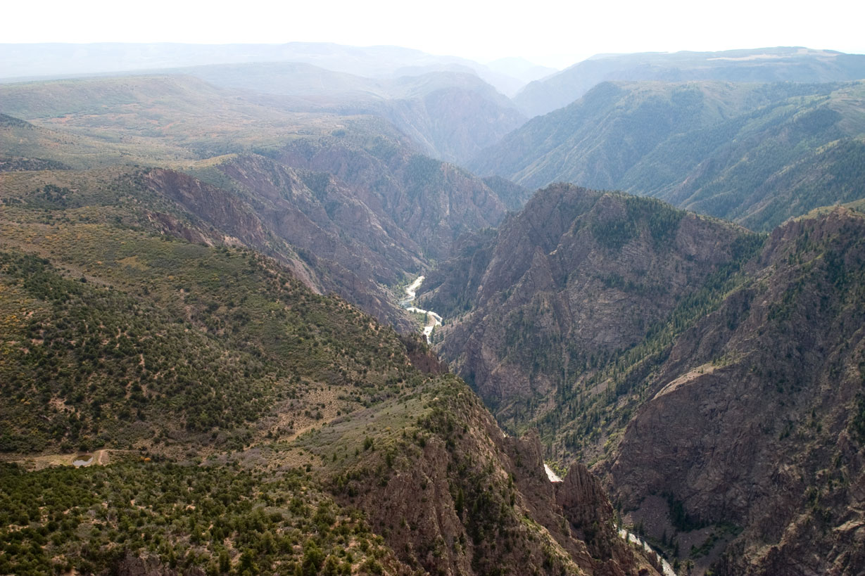
Black Canyon of the Gunnison is deeper than it is wide—the Gunnison River drops 43 feet per mile, steeper than the Colorado through the Grand. As of 2026, the park is cashless, water systems shut down October through April, and the South Rim Campground, East Portal Campground, and Rim Rock Trail remain closed after the 2025 South Rim Fire. Plan around these conditions.
NPS Photo/Lynch via NPS.gov (Public Domain)
Black Canyon of the Gunnison National Park: One of America's Most Dramatic Canyons - 2026 Guide
7 min read
Park Guide
Sheer 2,700-foot walls and a steeper river gradient than the Grand Canyon. Cashless entry, $30 per vehicle; water systems off October-April (2026).
Your plans
This article contains affiliate links — we may earn a small commission at no extra cost to you.
At a glance
Entrance Fee
Private vehicle $30 · Motorcycle $25 · Per person $15Full fee schedule
Hours
The South Rim is open 24 hours a day.
Address
South Rim Visitor Center, Montrose, CO, 81401
Website
38.5778, -107.7243
Google MapsGetting There and Park Logistics
Your experience hinges on which rim you choose—South or North. The South Rim serves as the main access, seven miles north of U.S. 50 near Montrose. The visitor center address is 9800 Highway 347, Montrose. The North Rim lies farther out, eleven miles southwest of Crawford, reached by a winding gravel road off CO 92. We see about a tenth of the visitation there. The views hold equal power, but the atmosphere shifts to one of deep solitude.
The parking situation here is straightforward but has critical seasonal nuances. The South Rim Road beyond the visitor center is closed to vehicles in winter. The North Rim Road is gated shut at the park boundary from roughly mid-November through late April. If you're visiting between October and April, assume you will need to bring all your own drinking water - the park's water systems are shut off. The gift shop sells bottled water, but the supply isn't guaranteed and the price reflects the remoteness. Bring your own.
Entrance fees as of 2026 are $30 per private vehicle for a 7-day pass, $25 for a motorcycle, or $15 per person for those on foot or bicycle. A critical update: all park operations are now cashless. They accept credit and debit cards, and Apple/Google Pay. If you're aiming for a first-come, first-served campsite on the North Rim or at East Portal, you'll need to use the Recreation.gov mobile app to "Scan & Pay." Have your phone charged and the app downloaded before you arrive, because cell service drops out at the park boundary.
Navigating Current Closures
The 2025 South Rim Fire reshaped access. As of 2026, the South Rim Campground, East Portal Campground, and the Rim Rock Trail between the South Rim Campground and Tomichi Point are closed indefinitely. This alters traditional itineraries. The East Portal Road - the steep, winding access down to the Gunnison River - is also closed in winter, managed by the U.S. Bureau of Reclamation. Always check the official NPS website for the latest status before you load the car. These aren't minor inconveniences; they determine where you can sleep and which trails you can walk.

Experiencing the Scale: South Rim vs. North Rim
From the South Rim, the canyon presses close. The road traces the edge, offering a dozen pullouts and overlooks within the first few miles. Painted Wall View draws every visitor—you're looking straight at the canyon's tallest cliff, a 2,250-foot vertical face of black-and-white pegmatite that resembles a colossal marble cake. The sightline drops to the river, a thin, frothing white thread nearly half a mile down. For photography, aim for early morning, when low sun sharpens the rock textures and shadows etch the inner canyon.
The trail narrows here along the Rim Rock Nature Trail, offering a quieter perspective. Most visitors underestimate the wind. It funnels up and over the rim with surprising force, a constant reminder of the atmospheric river flowing through the deep cut.
The North Rim requires more commitment. The drive in is slower, the facilities are basic (vault toilets, no water), and the overlooks are reached via short spurs from a loop road. The payoff is a more intimate, raw confrontation with the depth. From Chasm View, the canyon is only 1,100 feet across at the rim. You can hear the Gunnison River - a distant, constant roar. The Exclamation Point hike is a flat, easy 1.5-mile round trip that ends at a promontory with arguably the park's most dramatic sheer-drop view. You'll likely have it to yourself.
Rangers emphasize that there are no rim-to-rim bridges or trails. Crossing the canyon requires a 2-3 hour drive around the park's eastern end. This isn't a place for a leisurely rim-to-rim stroll. It's a place for standing at the edge and looking down.

Hiking, Climbing, and River Access
The park's hiking trails break into two distinct categories: rim walks and inner canyon descents. The rim trails are generally flat, paved or packed gravel, and accessible. The inner canyon routes are a different universe. These are unmaintained, steep, loose, and require a free wilderness use permit obtained at the visitor center. Routes like the Gunnison Route or the SOB Draw involve scrambling, navigating steep scree slopes, and using installed chains or ropes in sections. Your calves will have strong opinions about the climb back out. These are not beginner hikes. Rangers will tell you that rescue times are measured in hours, not minutes.
For rock climbers, the Painted Wall is a legendary big-wall challenge. Climbs here are multi-day technical endeavors for experts only. The rock is notoriously hard and brittle - a quality of the ancient Precambrian gneiss and schist. Most visitors are content to watch through binoculars as tiny, colorful specks slowly ascend the face.
Reaching the river is possible without a harrowing descent. The East Portal Road (when open) switchbacks down a 16% grade to the water's edge. This is where you'll find anglers casting for trout in the Gold Medal waters. The sound changes here from a distant roar to a powerful, churning rush. The temperature can be 20 degrees warmer than on the rim. It's a completely different ecosystem, lush and loud. This is also the primary access point for ranger-led activities and tours and guided experiences focused on the river corridor.

When to Visit and What to Do
The best time to visit depends entirely on your tolerance for weather. Summer (June-August) brings warm days between 55-90°F, but afternoon thunderstorms roll in with little warning. The lightning here is no joke - the high, exposed rims are dangerous places in a storm. Winter (December-February) is cold, with highs of 15-40°F and snow that can close roads. This is when the park becomes a destination for cross-country skiing and snowshoeing along the rim. The silence is profound, and the snow highlights the geologic striations in the cliffs.
Spring and fall are the sweet spots. May and September offer mild temperatures, fewer people, and active wildlife viewing. You might see mule deer browsing the rim, peregrine falcons diving along the cliffs, or the elusive black bear in the upland forests.
Beyond hiking, the park is an International Dark Sky Park. The night sky from the rim is a revelation. On moonless nights, the Milky Way appears as a thick, dusty band directly over the canyon's void. The park hosts regular astronomy programs. Stargazing requires no permit - just find a safe pullout away from your headlights, let your eyes adjust, and look up.
For families, the Junior Ranger program is a solid way to engage kids with the geology. Anglers need a Colorado fishing license and are subject to special park regulations for the Gunnison River. Your camping options are limited, especially with the South Rim Campground closed. The North Rim Campground is small, primitive, and operates on that first-come, first-served Scan & Pay system. For more comfort, look to lodging and accommodations in Montrose or Crawford.

Practical Takeaways
- Bring All Your Water From October to April. The park's water systems are shut off. Even in summer, carry more than you think you need - the dry air and elevation dehydrate you quickly.
- Bring Plastic, Not Cash. The park is entirely cashless as of 2026. Have a credit/debit card or digital wallet ready for entrance fees and any payments.
- Check Closure Status the Day You Go. The wildfire closures on the South Rim are significant. Verify the status of the South Rim Road, campgrounds, and East Portal Road via the official NPS website or a call to the visitor center.
- Dress in Layers, Always. Temperatures swing 30 degrees between day and night, and weather changes fast. A windbreaker is essential on the rim.
- Stay Back from the Edge. This isn't a generic warning. The rim rock is unstable, there are no guardrails at most overlooks, and a misstep is fatal. Watch your footing closely.
- Download the Recreation.gov App. If you hope to snag a first-come, first-served campsite at North Rim or East Portal, you must use the app to register and pay. Do this before you lose cell signal.
- Fuel Up in Montrose or Crawford. There are no gas stations in the park. The nearest services are in these towns.
Final Thoughts
Black Canyon of the Gunnison doesn't try to impress you with vastness. It impresses you with severity. The scale is vertical, the history is measured in billions of years, and the river's work is audible from the rim. It's a park that rewards stillness. Sit at an overlook for twenty minutes, not two. Watch the shadows lengthen across the Painted Wall. Listen for the raven's croak echoing off the opposite cliff. This place is less about checking off overlooks and more about comprehending depth - both in the rock and in time. It's one of the few parks where you can park your car, walk fifty feet, and be confronted with a view that literally takes your breath away. Just remember to pack your own water.
Recommended Gear
What experienced visitors bring to Black Canyon of the Gunnison National Park: One of America's Most Dramatic Canyons - 2026 Guide
Links may earn us a commission at no extra cost to you. We only recommend gear we believe in.
Hiking Essentials
Hydration Pack (3L)
Hands-free water for long trail days
Trekking Poles (Pair)
Save your knees on steep descents
Hiking Boots (Ankle Support)
Sturdy footwear for rocky, uneven trails
Sun & Heat Protection
Wide-Brim Sun Hat
Full coverage UPF 50+ protection at altitude
Insulated Water Bottle (32oz)
Keeps water cold in desert heat all day
Electrolyte Mix Packets
Replace what water alone cannot during intense heat
Winter Gear
Microspikes / Traction Devices
Essential for icy rim trails in winter months
Packable Down Jacket
Lightweight warmth that stuffs into a pocket
Sources
- Official source: NPS — Black Canyon of the Gunnison National Park nps.gov/blca/index.htm
Explore More National Parks

Fly to Arches National Park: Nearest Airports & Tips (2026)
Discover where to fly to visit arches national park with our comprehensive guide. Expert tips, pract...

Mesa Verde National Park: Ancient Cliff Dwellings & Ancestral Puebloan Sites - 2026 Guide
Discover ancient Ancestral Puebloan cliff dwellings and mesa ruins. Complete 2026 guide to Mesa Verd...

Canyonlands National Park: Utah's Wildest Canyon Country - 2026 Guide
Canyonlands has zero restaurants inside the park. 2026 guide to where to eat near each of its three...

Great Sand Dunes National Park: North America's Tallest Sand Dunes - 2026 Guide
Arrive before 7 AM to beat crowds and heat at Great Sand Dunes National Park, where summer sand hits...
Photo Gallery
More to Explore

Park Guide
Acadia National Park: Carriage Roads, Cadillac Mountain & 2026 Guide
Discover carriage roads, Cadillac Mountain, and rugged Maine coast. Complete 2026 guide to Acadia National Park — trails, fees, lodging, permits, and what rangers recommend.

Hiking Guide
Grand Canyon Hiking Trails: Day Hikes, Water Sources & Rim to Rim
Compare Grand Canyon hiking trails: Bright Angel, South Kaibab, Hermit, Grandview, and rim to rim, with distances, elevation, water stops, and trailhead access for each.

Best Of
Best of Glacier Bay National Park
The best of Glacier Bay is reached by boat: ranger-led day tours up the bay to the tidewater glaciers. What's worth it, how to book, and when to go (2026).

Campsite Guide
White Sands Backcountry Camping: Closed for 2026 — What to Know
As of 2026, backcountry camping at White Sands National Park is closed for site rehabilitation. What that means, and where to camp nearby instead.

Weather Guide
Guadalupe Mountains National Park Weather: Weather
Guadalupe Mountains National Park: weather guide guide updated 2026. Practical visitor information, reservations, and seasonal tips worth bookmarking before

Best Of
Best of Cuyahoga Valley National Park: Best Things to Do
Seeing a Cleveland Orchestra concert with the woods as your backdrop is a uniquely Cuyahoga Valley experience.
Sign in to join the conversation.
Sources & Attribution
Location data courtesy of the National Park Service (U.S. Department of the Interior). NPS data is public domain. Official NPS page.
Images: NPS Photo/Lynch; NPS Photo/Lynch; Photo by Pixabay on Pexels; Photo by Pixabay on Pexels; Photo by Pixabay on Pexels. Stock photos from Pexels / Unsplash license; links above point to each photo where available.
Map data © OpenStreetMap contributors.
Park operations alerts: NPS.gov · Weather and weather hazards: National Weather Service · Live conditions.
Information may change. Always verify fees, hours, and conditions directly with the official source before visiting.
Did this guide help? Share it with a friend.