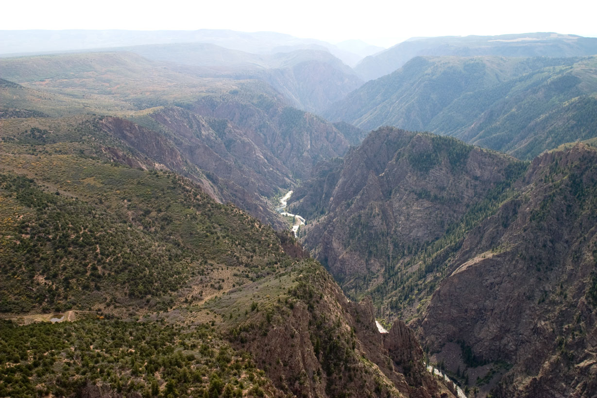
First-time visitors are often caught off guard by the temperature gradient between rim and river. On the South Rim, you might find yourself in 85-degree sunshine while the Gunnison River flows through shadows at a brisk 50 degrees. This vertical relief creates three distinct climate zones within the park boundaries. Most folks stick to the rim, but proper planning requires knowing your destination. The Montrose forecast won't mention the wind channeling through the inner canyon or the ice that persists on north-facing trails well into May.
NPS via NPS.gov (Public Domain)
Black Canyon of the Gunnison National Park Weather: Weather
9 min read
Weather Guide
First-time visitors are often caught off guard by the temperature gradient between rim and river. Updated for 2026 with 5 Black Canyon of the Gunnison National
Related reading: camping options.
The Weather Reality
Positioned in the rain shadow east of the Rockies, the park receives less precipitation than its elevation might suggest. What's lacking in rainfall is compensated by abundant sun and persistent wind. At approximately 8,000 feet, the South Rim experiences over 245 sunny days annually. UV radiation at this altitude is severe—a clear 60-degree April day can sunburn you quicker than a 90-degree day at sea level.
The canyon itself acts as a wind tunnel. Westerly winds get compressed and accelerated as they funnel through the narrow gorge. Rangers will tell you that a mild breeze on the rim can become a sustained, forceful wind down on the river, enough to knock a pack off a rock or make crossing the Gunnison feel precarious. This wind-chill effect is a constant, often unforecasted companion.
Then there's the monsoon. From mid-July through August, moisture rides up from the Gulf of California, leading to brief but violent afternoon thunderstorms. These aren't gentle rains. They are sudden deluges that can drop a half-inch of rain in 20 minutes, turning dusty trails into slick mud and creating instant runoff. Lightning is a serious threat on the exposed rims. The flip side? These storms fuel the late-summer wildflower displays and clean the dust from the air, creating some of the clearest views of the year in their aftermath.
Month by Month
April - May
Temperatures on the rim range from highs in the 50s to low 60s, with overnight lows often dipping below freezing. Snow is still possible, especially in April.
This is the shoulder season. The South Rim Road is open, but the North Rim Road typically remains closed until mid-May due to snowpack and mud. The East Portal Road (descending to the river) opens as conditions allow, usually by late April.
Crowds are light. You'll have overlooks mostly to yourself.
Trail conditions are variable. South Rim trails may be clear but muddy. North Rim trails and the inner canyon routes remain snow-packed, icy, and treacherous. The black rock of the canyon walls absorbs sunlight, melting snow above and creating hazardous ice flows on steep descent routes like the Gunnison Route. Crampons or microspikes are still essential gear for any serious hiking.
Wildlife is active. You might see elk moving to lower elevations and hear the first migratory birds returning.
Worth it for: Solitude and dramatic, snow-dusted canyon views.
Challenging because: Unpredictable conditions. One day can be sunny and calm, the next can bring a spring snowstorm. River access is often limited or dangerous due to high, cold runoff from melting snow.
June
Rim highs climb into the 70s, with pleasant, cool nights in the 40s. The river remains cold, in the 40s to low 50s.
All park roads are open. The North Rim campground opens.
Crowds begin to build, especially on weekends, but are manageable on weekdays.
Trail conditions improve dramatically. Most rim trails are dry. Inner canyon routes (the "Routes") are passable but still demanding. The river is often at peak flow, making crossings dangerous and fishing difficult.
Wildflowers start to appear on the rims by late June.
Worth it for: Reliable access, good hiking weather, and long days.
Challenging because: Afternoon thunderstorms begin to fire up by month's end. Mosquitoes can be fierce near the river.
July - August
This is peak summer. South Rim highs average in the low 80s, but can spike into the 90s. North Rim, being slightly higher, is often 5-10 degrees cooler. Nights are cool, in the 50s. The monsoon season is in full swing.
Everything is open and operating at full capacity.
Crowds are at their peak. The South Rim Visitor Center parking lot can fill by mid-morning. The North Rim sees significantly fewer visitors.
Trail conditions are generally dry, but afternoon storms can create sudden slickness and flash flood risk in the inner canyon. Heat on the exposed rims is a real concern - hike early.
This is prime time for seeing peregrine falcons soaring on thermal currents. Wildflowers, especially sunflowers and paintbrush, peak in July on the rims.
Worth it for: Guaranteed access, warm weather, and vibrant plant life.
Challenging because: Crowds and the daily thunderstorm cycle. You must be off high points and out of the inner canyon by early afternoon. Haze from distant fires can sometimes obscure views.
September - October
The most stable weather window. September rim highs are in the 70s, dropping to the 50s and 60s by October. Nights become crisp, with frequent frost by mid-October. The first snow can dust the rims in late October.
Facilities begin to wind down. The North Rim Road and campground usually close in mid-October, depending on snow.
Crowds thin significantly after Labor Day, offering a peaceful experience.
Trail conditions are excellent - dry, stable, and cool. It's the best time for tackling the strenuous inner canyon routes. The river drops and clears, making for excellent fishing.
The aspen and oak brush on the rims turn gold and red in late September.
Worth it for: Ideal hiking temperatures, fewer people, and autumn colors.
Challenging because: Shorter days and the increasing likelihood of an early winter storm shutting down the North Rim.
November - March
Winter. Rim highs struggle to get above freezing, often in the 20s and 30s. Lows plummet into the single digits or below zero. The South Rim receives an average of 30-40 inches of snow; the North Rim gets more. The inner canyon is perpetually cold and icy.
The South Rim Road is plowed to the visitor center, but beyond that, it's closed to vehicles and becomes a trail for skiing and snowshoeing. The North Rim Road is closed at the park boundary. The East Portal Road closes for the season.
Crowds are virtually nonexistent. You might see a handful of other visitors all day.
Trail conditions are snow-covered and icy. Only experienced winter adventurers should venture beyond the plowed areas. The inner canyon routes are inaccessible and extremely hazardous.
Wildlife tracks - from rabbit to mountain lion - are everywhere in the fresh snow.
Worth it for: Absolute solitude, snow-covered canyon vistas, and cross-country skiing.
Challenging because: Extreme cold, limited access, and the need for serious winter survival gear and knowledge. Services are minimal.
Best Times for Specific Activities
Hiking the Inner Canyon "Routes"
The narrow, steep, unmaintained paths to the river are a core challenge here. The absolute best window is mid-September to mid-October. The monsoon has passed, the air is cool, the rock is dry, and the river is low enough for safer crossings. Early June is a distant second choice, but high, cold river water adds significant risk.
Rim Hiking and Overlooks
For comfortable, crowd-free strolls along the rim trails like the Warner Point or North Vista Trail, aim for June or late September. You'll avoid the peak summer heat and the largest tour groups. Wildflowers are a bonus in June.
Wildlife Viewing
May and June are best for mammal activity - elk, mule deer, and the occasional black bear are moving at dawn and dusk. For birders, late spring (May-June) brings migratory species, while July-August offers the best chance to see peregrine falcons teaching their young to fly along the cliff faces.
Stargazing and Night Sky Photography
The park's remote location and high elevation make it a International Dark Sky Park. The clearest, darkest nights are in fall (September-October) and winter. The air is driest, and the Milky Way is visible in detail. Winter offers the longest nights, though you'll have to contend with the cold.
Fishing the Gunnison River
The Gold Medal Waters of the Gunnison are accessible via the East Portal Road. While fishing is open year-round, conditions are best after runoff subsides, from late July through October. The water is lower, clearer, and warmer. In winter, access is a major hike and the water is brutally cold.
What to Pack by Season
Spring (April-May): Layers are non-negotiable. A moisture-wicking base layer, insulating mid-layer (fleece or puffy), and a waterproof/windproof shell. Sturdy hiking boots with traction devices (microspikes or crampons) are essential for any trail with elevation change. Warm hat and gloves. The sun is intense - pack a wide-brimmed hat, sunglasses, and high-SPF sunscreen.
Summer (June-August): Lightweight, breathable clothing that covers your skin for sun protection. A wide-brimmed hat is more valuable than a baseball cap. Rain jacket and pants - not a poncho, which will shred in the canyon wind. Plenty of water capacity (3+ liters per person for a rim hike, more for the inner canyon). Trekking poles for stability on steep, loose descents. Start your day early. Your pack should be ready to go by sunrise.
Fall (September-October): Similar to spring layering. A warm jacket for chilly mornings and evenings. Traction devices might still be needed for early morning frost on trails. Daylight fades faster - always carry a headlamp.
Winter (November-March): Expedition-level cold weather gear. Heavy insulated parka, insulated waterproof pants, balaclava, mountaineering gloves, and insulated waterproof boots. Snowshoes or cross-country skis for travel beyond the plowed road. Gaiters. An emergency shelter and sleeping bag are advised for any extended travel. Check in at the visitor center before heading out.
What the Forecast Doesn't Tell You
- The Rim is a Lie. The comfortable temperature at the overlook is not the temperature 2,000 feet down. The inner canyon can be 20 degrees cooler and completely shaded by mid-afternoon, even on a summer day. Pack for both climates.
- Wind is a Constant. It's not just breezy. It's a persistent, draining force that dehydrates you faster and chills you to the bone, even in sunshine. A windbreaker lives in your daypack, always.
- Lightning Likes the High Points. The rims are the highest points around. When a thunderstorm approaches, you are the lightning rod. The rule is simple: if you can hear thunder, you are already within striking distance. Your turn-around time should be hours before storms are forecast.
- The Rock is Abrasive. The Precambrian gneiss and schist that form the canyon walls are incredibly hard and sharp. One slip on a trail can result in deep cuts, not just scrapes. Gloves are useful for more than warmth.
- Hydration is a High-Altitude Game. At 8,000 feet, you lose moisture through respiration much faster than at sea level. You need to drink about 1.5 times more water than you think, and that's before accounting for hiking. Headaches are the first sign you're behind.
- Snow Melts in the Wrong Direction. Spring snowmelt doesn't just run down trails; it seeps through the canyon walls and refreezes overnight on the steep descent routes, creating invisible ice sheets on the rock. This is the primary cause of early-season accidents.
- Cell Service Drops Out at the first overlook. Don't rely on your phone for weather updates, navigation, or emergencies. Download maps and forecasts beforehand.
Practical Takeaways
- For the best overall experience - good weather, open trails, and fewer people - target the month of September.
- Regardless of the season, pack for three different weather conditions: the rim, the descent, and the river. That always means layers, a shell, and extra water.
- Hike early. In summer, be on the trail by 7 AM and aim to be back at your car or at a safe, low point by 1 PM to avoid thunderstorms. In winter, you need all the daylight you can get.
- The North Rim closes for winter, usually by mid-October. The South Rim is your year-round access point, but services are minimal from November through April.
- Check the river flow rate if you plan to hike to the Gunnison. The park service recommends against crossing when flows are above 300 cubic feet per second (cfs). This information is posted at the visitor centers.
- Your footwear choice is critical. Sturdy hiking boots with aggressive tread are the minimum for rim trails. For the inner canyon routes or any off-season hiking, traction devices are mandatory safety equipment, not an optional extra.
- The park's black canyon of the gunnison national park weather is defined by vertical extremes. Your preparation should be, too. For the latest trail conditions and road status, always check the official National Park Service website or call the South Rim Visitor Center before you arrive.
For more detailed planning on where to stay and hike, see our complete visitor guide and specific advice on the park's hiking trails.
Sources
- Official source: NPS — Black Canyon of the Gunnison National Park nps.gov/blca/index.htm
More to Explore

Park Guide
Acadia National Park: Carriage Roads, Cadillac Mountain & 2026 Guide
Discover carriage roads, Cadillac Mountain, and rugged Maine coast. Complete 2026 guide to Acadia National Park — trails, fees, lodging, permits, and what rangers recommend.

Hiking Guide
Grand Canyon Hiking Trails: Day Hikes, Water Sources & Rim to Rim
Compare Grand Canyon hiking trails: Bright Angel, South Kaibab, Hermit, Grandview, and rim to rim, with distances, elevation, water stops, and trailhead access for each.

Best Of
Best of Glacier Bay National Park
The best of Glacier Bay is reached by boat: ranger-led day tours up the bay to the tidewater glaciers. What's worth it, how to book, and when to go (2026).

Campsite Guide
White Sands Backcountry Camping: Closed for 2026 — What to Know
As of 2026, backcountry camping at White Sands National Park is closed for site rehabilitation. What that means, and where to camp nearby instead.

Weather Guide
Guadalupe Mountains National Park Weather: Weather
Guadalupe Mountains National Park: weather guide guide updated 2026. Practical visitor information, reservations, and seasonal tips worth bookmarking before

Best Of
Best of Cuyahoga Valley National Park: Best Things to Do
Seeing a Cleveland Orchestra concert with the woods as your backdrop is a uniquely Cuyahoga Valley experience.
Sign in to join the conversation.
Sources & Attribution
Location data courtesy of the National Park Service (U.S. Department of the Interior). NPS data is public domain.
Images: NPS; NPS.
Map data © OpenStreetMap contributors.
Park operations alerts: NPS.gov · Weather and weather hazards: National Weather Service · Live conditions.
Information may change. Always verify fees, hours, and conditions directly with the official source before visiting.
Did this guide help? Share it with a friend.