For more, see camping options and best time to visit.
NPS via NPS.gov (Public Domain)
Arches National Park Hiking Permit
10 min read
Hiking Guide
Secure your 2026 Arches hiking permit. Trails are slickrock routes, not forest paths. Learn essential desert skills like route-finding and flash flood safety.
This article contains affiliate links — we may earn a small commission at no extra cost to you.
Arches National Park Hiking: Hiking Permit (2026 Guide)
What Hiking Here Actually Means
Hiking in Arches is a negotiation with slickrock. Your trail is often a series of rock cairns leading across exposed sandstone domes, not a dirt path through woods. The skill required isn't technical climbing but route-finding and heat management. First-time visitors consistently underestimate two things: the deceptive scale on the map - a one-mile hike here can feel like three under the desert sun - and how quickly a dry wash can become a dangerous flash flood channel. This isn't a park for long, forested treks; it's a park for short, intense walks to geological spectacles. Your preparation should focus on water, traction, and timing, not distance.
Delicate Arch: The Obligatory Pilgrimage
Most visitors come for this. It's the arch on the license plate, and the 1.5-mile uphill slog to see it is the park's most crowded trail. Rangers will tell you it's moderate; your legs on the open sandstone climb may have a different opinion.
Distance: 3.0 miles roundtrip
Elevation Gain: 480 feet
Trailhead & Parking: Wolfe Ranch parking lot. This is ground zero for congestion. On any day from March through October, the lot is full by 7:30 AM. Overflow parking spills along the main road for nearly a mile - parking on vegetation or blocking traffic will get you a ticket. There is no shuttle to this trailhead. Your best strategy is to arrive before sunrise or late afternoon.
The Trail: It starts flat on a gravel path past the old cabin, then begins a steady, exposed climb up slickrock. The trail narrows here, marked solely by cairns. The final 200 yards traverse a rock ledge with a significant drop-off on one side - it's wide enough, but it gives many people pause. The arch isn't visible until you round the final corner into the vast, bowl-like amphitheater.
The Moment: Turning that last corner to see the arch framed against the La Sal Mountains, standing alone on the far edge of the bowl. It's smaller and more orange in person than in photos, which somehow makes it better.
What Most Underestimate: The complete lack of shade and the intensity of the sun reflecting off the white sandstone. You'll drink twice the water you think you need. Also, the ledge section feels more exposed than the photos suggest.
Best Time: Sunset is the classic, crowded photo op. Sunrise is far quieter and the light is softer. Midday in summer is borderline dangerous due to heat.

Devils Garden (Primitive Trail): The Full Experience
This is the park's signature long hike, a 7.2-mile loop that passes eight major arches. The "Primitive Trail" section is where the real adventure starts, requiring scrambling and careful navigation.
Distance: 7.2-mile loop
Elevation Gain: 1,085 feet
Trailhead & Parking: The Devils Garden lot at the very end of the park road. It fills by 8 AM. Once full, rangers often close the road to additional traffic until spots open up. Plan to be here by 7 AM or accept a long wait.
The Trail: The first section to Landscape Arch (1.6 miles roundtrip) is a wide, popular path. Beyond that, the trail becomes a route. You'll climb on narrow fins of rock, descend into sandy washes, and use your hands to navigate short, steep sections. The cairns are essential - pay attention. If you lose the route, stop and scan.
The Moment: Standing beneath Landscape Arch, a thin ribbon of rock spanning 306 feet. It feels impossibly fragile. The second moment is the quiet solitude you find on the back half of the primitive loop, once the crowds from the short hikes turn around.
What Most Underestimate: The primitive trail's technicality. It's not a walk. It requires balance, some mild exposure, and comfort with scrambling. Many turn back after Landscape Arch, which is a wise choice if you're unsure.
Best Time: Early morning, full stop. You need to finish before the afternoon heat bakes the exposed fins of rock. Spring and fall are ideal; summer requires an extremely early start and massive water carry.
Fiery Furnace: The Ranger-Led Maze
This isn't a marked trail; it's a labyrinth of narrow sandstone canyons. Access requires a permit or a ranger-guided hike. It's the park's most unique hiking experience, demanding physical agility and spatial awareness.
Distance: Roughly 2 miles on the guided hike, but distance is irrelevant here.
Elevation Gain: Variable, with constant small climbs and drops.
Trailhead & Parking: A dedicated lot just off the main road, about 14 miles from the entrance. It's smaller than the main trailhead lots but fills quickly for tour times.
The Trail: There is no trail. You will squeeze through cracks narrower than your shoulders, chimney down short drops, and walk along sandy canyon bottoms. The ranger will point out micro-ecosystems, hidden arches, and geological details you'd never see on your own. It's part hike, part puzzle.
The Moment: The realization of how disorienting the canyons are, and the quiet that exists just a few twists away from the main road.
What Most Underestimate: The physical requirement. The tour involves stemming, scrambling, and occasional jumps of 2-3 feet. If you have significant mobility issues or a strong fear of confined spaces, this isn't for you. You must carry - and drink - all your water for the duration; there are no bail-out points.
Best Time: The guided hikes are offered spring through fall. Morning tours are cooler. This is one hike where summer heat is particularly punishing in the enclosed canyons.

Park Avenue: The Canyon Walk-Through
Often treated as a quick stop, this trail is a perfect introduction to the scale of the park. It's a one-way hike best done with a car shuttle, or an out-and-back.
Distance: 2.0 miles one-way (shuttle required) or 1 mile out-and-back to the first major formations.
Elevation Gain: 320 feet (net loss if hiking one-way north to south).
Trailhead & Parking: The main Park Avenue viewpoint and parking lot. The lot is large but still fills by mid-morning. The north end trailhead is at the Courthouse Towers viewpoint, which has limited parking.
The Trail: A well-defined path that descends steeply from the viewpoint into a wide canyon. You walk between massive monoliths like the Three Gossips and the Courthouse Towers. The terrain is packed dirt and rock with a few stone steps.
The Moment: Looking up from the canyon floor at the sheer walls, feeling the depth and silence that you can't appreciate from the roadside pullout.
What Most Underestimate: The climb back out if you don't set up a shuttle. The 320-foot ascent at the end, especially in heat, is a gut-check for many who thought this was just a "viewpoint."
Best Time: Late afternoon light turns the canyon walls a deep, glowing red. It's also a good option when other lots are full, as many people just look from the top and leave.
Double O Arch: The Devils Garden Extension
For those not ready for the full primitive loop, this is the logical extension past Landscape Arch. It offers more solitude and another impressive arch formation.
Distance: 4.2 miles roundtrip from Devils Garden Trailhead
Elevation Gain: 500 feet
Trailhead & Parking: Same as Devils Garden. The parking reality dictates your entire day.
The Trail: Continues past Landscape Arch on a trail that becomes progressively more rugged. You'll hike along the top of a narrow fin with exposure on both sides - the footing is good, but it's not for those with a severe fear of heights. The final approach involves some slickrock scrambling.
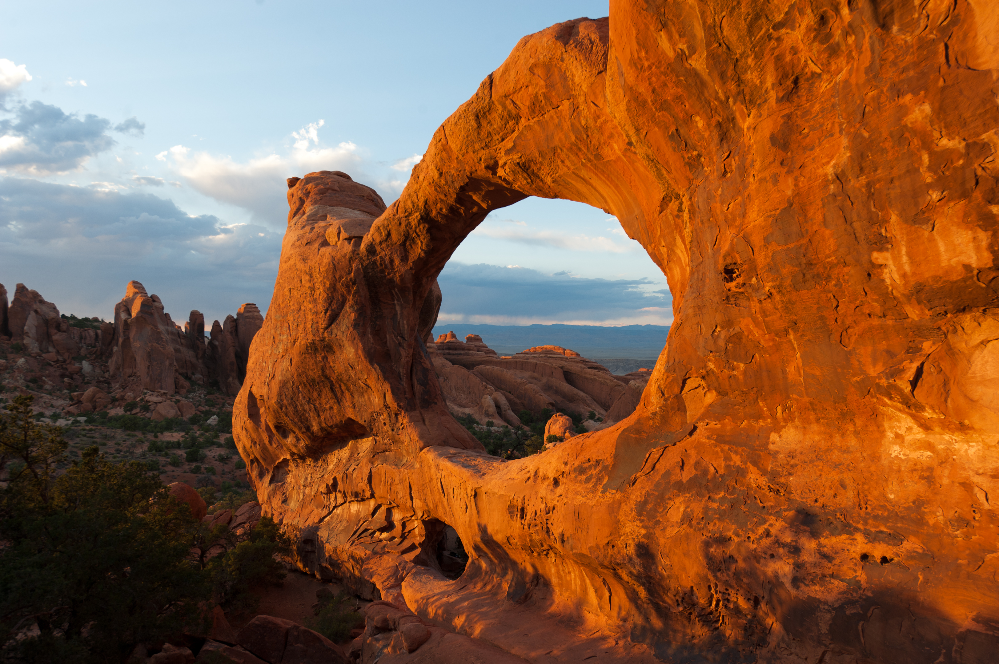
The Moment: Seeing the smaller "O" arch stacked beneath the larger one, a unique double-decker formation.
What Most Underestimate: The exposure on the fin. It's not technically difficult, but the sense of height is real. The trail narrows here significantly.
Best Time: Early morning to secure parking and avoid the heat on the exposed fins.

Sand Dune & Broken Arch: The Family-Friendly Loop
A flat, easy circuit that feels worlds away from the crowded Delicate Arch trailhead just down the road. It's a good choice for families or a leg-stretch.
Distance: 1.4-mile loop
Elevation Gain: Minimal
Trailhead & Parking: The Sand Dune Arch parking area. This is a smaller lot that fills quickly because it also serves as access for Sand Dune Arch (a 0.3-mile walk). If full, you may need to circle back later.
The Trail: A sandy path through open grasslands and scattered junipers to the base of Broken Arch (which isn't actually broken). You can walk right through the arch's span. The sand can be soft and slow-going, especially for small children.
The Moment: Letting kids run through the wide, sandy wash and play in the shade of the arch itself.
What Most Underestimate: How hot the sand gets by mid-day. Wear closed-toe shoes, not sandals.
Best Time: Morning or evening. Midday sun on the open grassland is intense.
Seasonal Trail Conditions
March-May: The prime window. Daytime temps are manageable (60s-80s F), but nights are cold (30s-50s F). Crowds ramp up steadily through April. Flash flood risk begins with spring storms. This is the best time for the longer hikes like Devils Garden.
June-August: Survival hiking. Temperatures consistently exceed 100 F on the exposed rock. Hiking after 10 AM is not recommended for any trail longer than a mile. Your water planning is critical - carry a minimum of one gallon per person for a half-day. Monsoon season (July-August) brings sudden, violent thunderstorms and high flash flood danger in canyons like the Fiery Furnace. Start hikes at or before sunrise.
September-October: A second prime season. Crowds thin slightly after Labor Day, and temperatures return to the pleasant 60s-80s F range. Days are shorter. This is an excellent time for all hiking.
November-February: Winter hiking. Daytime highs average 30-50 F, with lows often below freezing. Snow and ice are possible, transforming the slickrock into a hazardous slide. Traction devices (microspikes) are essential for any hike with elevation change, like Delicate Arch. The trails are empty, but the conditions are serious. Check at the visitor center for ice reports.

Trailhead Logistics
The park's single road creates a bottleneck. The timed entry permit system (required from April through October as of 2026) manages the entrance queue, but it doesn't guarantee a parking spot at your desired trailhead. Your permit grants you an arrival window; once in, you're competing for parking.
Parking Strategy: For Delicate Arch or Devils Garden, you must be parked by 7:30 AM at the absolute latest. For other trailheads, aim for before 9 AM. If a lot is full, do not park on vegetation or along the road where tires leave the pavement - rangers patrol and ticket aggressively. Your only option is to try another trailhead or return later.
Shuttles: As of 2026, Arches does not have an internal shuttle system. You drive to every trailhead.
Cell Service: Drops out completely about a mile past the entrance station. Do not rely on your phone for maps or communication. Download offline maps and trail guides before you arrive.
Water: There are no water sources on any trail. The only potable water fill stations are at the visitor center near the entrance and at the Devils Garden trailhead (seasonal, check if operational). Assume you will carry all you need from your car.
Trail Conditions: Stop at the visitor center. The rangers post a daily trail conditions sheet noting ice, mud, or high water. This is your best source of ground truth.
What to Carry
Forget the generic list. For Arches, your pack needs three things above all else: water, traction, and sun protection.
Water: One gallon per person, per half-day, is the minimum recommendation for summer. For a hike like Devils Garden in July, that means carrying 2+ gallons. Use insulated reservoirs or bottles to keep it cool. Electrolyte tablets are a smart addition.
Footwear: Stiff-soled hiking shoes or boots with aggressive tread. The slickrock is like sandpaper when dry but becomes slippery when wet or sandy. Running shoes lack the ankle support for the uneven, rocky terrain on primitive trails.
Traction: From November through March, carry microspikes in your pack. A thin layer of ice on an inclined slickrock slope is a fall waiting to happen.
Sun Protection: A wide-brimmed hat, sunglasses, and high-SPF mineral sunscreen are non-negotiable. The sun reflects off the pale sandstone, effectively hitting you from above and below. Consider sun-protective clothing.
Navigation: A physical map and the ability to read cairns. On primitive trails, it's easy to wander off-route. Your phone GPS may work for basic location, but the trail networks aren't always detailed on apps.
Practical Takeaways
- The timed entry permit is your key to the gate from April-October. Book it online well in advance. It does not, however, reserve you a parking spot at any trailhead.
- Parking is the real limiting factor. Your daily itinerary is dictated by what time you secure a spot. Have a flexible list of priority hikes.
- Water calculations are not suggestions. Double what you think you'll drink, then add more. Dehydration and heat illness are the most common ranger responses.
- "Slickrock" is a misnomer when dry - it's grippy. But add water, sand, or ice, and it lives up to its name. Adjust your footing accordingly.
- The difference between a "moderate" and "strenuous" rating here often comes down to exposure and scrambling, not pure distance. Read trail descriptions for words like "fin," "ledge," or "primitive."
- Flash floods can happen in any canyon, even under a blue sky. Check the weather forecast, but know that rain miles away can send a wall of water your way. Never enter a narrow canyon if storms are predicted anywhere in the region.
- For the best light on the red rock and the best chance at parking, your alarm should be set for pre-dawn. Sunset hikes are popular, but you'll be hiking out in the dark - bring a headlamp.
- The visitor center's daily conditions sheet is the most valuable piece of paper in the park. It lists which trails have ice, mud, or other hazards.
- If you want to do the Fiery Furnace, you need to plan months ahead for the permit lottery or book a ranger-guided tour the second reservations open.
- Your hiking success here is 80% logistics (permit, parking, water) and 20% walking. Get the logistics right, and the trails will deliver. For broader context, our complete visitor guide covers everything from park history to other activities. If you're staying overnight, research the camping options well in advance, as they book up fast. Finally, choosing the best time to visit is crucial - a summer hike here is a fundamentally different, and more demanding, experience than a spring or fall one.
For more information, see our complete National Park Guide.
Related: arches hiking trails guide
Related: arches hiking trail guide
Recommended Gear
What experienced visitors bring to Arches National Park Hiking Permit
Links may earn us a commission at no extra cost to you. We only recommend gear we believe in.
Hiking Essentials
Hydration Pack (3L)
Hands-free water for long trail days
Trekking Poles (Pair)
Save your knees on steep descents
Hiking Boots (Ankle Support)
Sturdy footwear for rocky, uneven trails
Sun & Heat Protection
Wide-Brim Sun Hat
Full coverage UPF 50+ protection at altitude
Insulated Water Bottle (32oz)
Keeps water cold in desert heat all day
Electrolyte Mix Packets
Replace what water alone cannot during intense heat
Winter Gear
Microspikes / Traction Devices
Essential for icy rim trails in winter months
Packable Down Jacket
Lightweight warmth that stuffs into a pocket
Sources
- Official source: NPS — Arches National Park nps.gov/arch/index.htm
Photo Gallery
More to Explore

Park Guide
Acadia National Park: Carriage Roads, Cadillac Mountain & 2026 Guide
Discover carriage roads, Cadillac Mountain, and rugged Maine coast. Complete 2026 guide to Acadia National Park — trails, fees, lodging, permits, and what rangers recommend.

Hiking Guide
Grand Canyon Hiking Trails: Day Hikes, Water Sources & Rim to Rim
Compare Grand Canyon hiking trails: Bright Angel, South Kaibab, Hermit, Grandview, and rim to rim, with distances, elevation, water stops, and trailhead access for each.

Best Of
Best of Glacier Bay National Park
The best of Glacier Bay is reached by boat: ranger-led day tours up the bay to the tidewater glaciers. What's worth it, how to book, and when to go (2026).

Campsite Guide
White Sands Backcountry Camping: Closed for 2026 — What to Know
As of 2026, backcountry camping at White Sands National Park is closed for site rehabilitation. What that means, and where to camp nearby instead.

Weather Guide
Guadalupe Mountains National Park Weather: Weather
Guadalupe Mountains National Park: weather guide guide updated 2026. Practical visitor information, reservations, and seasonal tips worth bookmarking before

Best Of
Best of Cuyahoga Valley National Park: Best Things to Do
Seeing a Cleveland Orchestra concert with the woods as your backdrop is a uniquely Cuyahoga Valley experience.
Sign in to join the conversation.
Sources & Attribution
Location data courtesy of the National Park Service (U.S. Department of the Interior). NPS data is public domain. Official NPS page.
Images: NPS; NPS; NPS; NPS; NPS.
Map data © OpenStreetMap contributors.
Park operations alerts: NPS.gov · Weather and weather hazards: National Weather Service · Live conditions.
Information may change. Always verify fees, hours, and conditions directly with the official source before visiting.
Did this guide help? Share it with a friend.