Lower Pines Campground sits along the Merced River in Yosemite Valley at 4,000 feet elevation, and it has one thing many other valley campgrounds don't: direct access to the free shuttle route without needing to walk half a mile first. That alone makes it worth considering if you're planning a Yosemite trip in 2026 and want to minimize time spent in the car. The campground opens seasonally from mid-April to mid-October, with all 73 sites available by reservation only. If you've been searching for a reliable lower pines campground option that puts you close to food, trailheads, and the valley's main attractions, this is the site to target during the booking window.
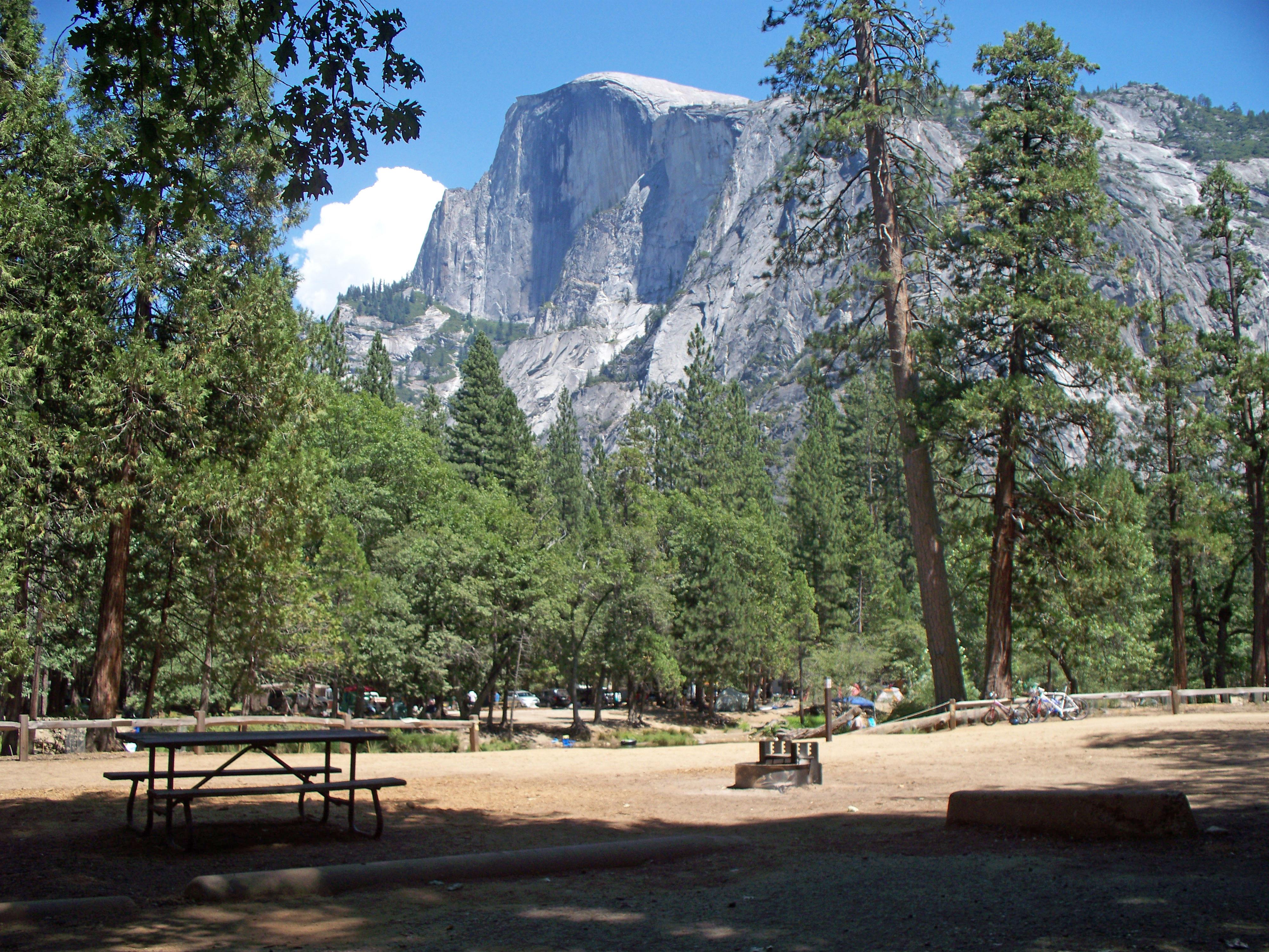
NPS via NPS.gov (Public Domain)
Campsites at Lower Pines Campground (2026 Guide)
7 min read
Campsite Guide
The ride from Lower Pines to Mirror Lake is about 3 miles one way and mostly flat - a solid morning option before the heat builds.
Your plans
For more, see Camp 4 Campground at Camp 4 Campground Yosemite National Park (2026 Guide), Campsites at Porcupine Flat Campground (2026 Guide), Campsites at Wawona Horse Camp (2026 Guide), Hodgdon Meadow Campground at Hodgdon Meadow Campground Yosemite National Park (2026 Guide), North Pines Campground at North Pines Campground Yosemite National Park (2026 Guide), and Tamarack Flat Campground at Tamarack Flat Campground Yosemite National Park (2026 Guide).
For a broader overview of what to expect during your stay, check the complete visitor guide from the park service, and if you're weighing other options, the all campgrounds page covers every site in the park.
Location and Getting There
Valley Floor Access
Lower Pines is one of three "Pines" campgrounds in Yosemite Valley, all clustered along Southside Drive near the Merced River. The address is 9024 Southside Drive, Yosemite, CA 95389. From the Arch Rock Entrance (Highway 140), you drive 8 miles west on El Portal Road into the valley. From the South Entrance (Highway 41), it's roughly 33 miles north on Wawona Road - about an hour of driving through forests before you drop into the valley.
The campground's position on the south side of the valley floor means you're within easy walking distance of Curry Village, where you'll find food services, a general store, and a gear rental shop. Yosemite Village is a slightly longer walk or a quick shuttle ride to the west.
Shuttle Access
This is where Lower Pines separates itself from the other valley campgrounds. The free shuttle route stops near the campground entrance, which means you can leave your vehicle parked at your site and use the shuttle to reach trailheads like the Mist Trail, Yosemite Falls, and Mirror Lake. The shuttle runs frequently during peak hours in spring, summer, and fall. Most visitors underestimate how much time they save by not having to circle for parking at popular trailheads. Take advantage of the shuttle.
Parking Situation
Each campsite comes with one designated parking space. If you're traveling with a second vehicle, you'll need to purchase an extra parking pass - and those sell out. Overflow parking is limited. The park service recommends arriving together in one vehicle if possible.

Campsite Details and Reservation Strategy
Site Types and Fees
Lower Pines has 73 total sites, with 9 designated for RV use. Regular sites run $36 per night as of 2026, and double sites - which are wider and can accommodate larger groups or multiple tents - cost $60 per night. RVs up to 40 feet and trailers up to 35 feet can fit, but note that not every site can handle the maximum length. When you book, the reservation system will show which sites match your rig's size.
All sites include:
- A fire ring and grill grate
- A picnic table
- A food storage locker (required for all food, coolers, and scented items - bears will test your compliance)
- Access to shared restrooms with flush toilets and running water
There are no hookups for RVs. No dump station in the campground itself, though one is available elsewhere in the valley.
When to Book
Reservations for Lower Pines open on a rolling window. The park uses Recreation.gov, and summer weekend sites in Yosemite Valley typically fill within minutes of becoming available. If you're aiming for a July or August stay, you need to be ready at 7 AM Pacific on the day your booking window opens.
The campground is open roughly mid-April through mid-October. The 2025-2026 winter closure runs from October 19, 2025 through April 21, 2026. Early May and late September tend to have the most availability and the best balance of pleasant weather versus crowds.
Which Site to Request
Loop A sits closest to the river. Sites in the 20s and 30s offer reasonable privacy by campground standards. Loop B has more shade from the pines the campground is named for. Loop C tends to be the quietest, backing up against the forest edge rather than the road. Rangers will tell you that no site in Lower Pines is truly secluded - this is a developed campground in Yosemite Valley, not backcountry camping - but some sites are noticeably better than others for privacy.

Activities Within Walking or Shuttle Distance
Hiking
Your campsite doubles as a trailhead access point. The Mist Trail to Vernal Fall and Nevada Fall is a short shuttle ride or a 20-minute walk east. The John Muir Trail connects to the same destinations. Early morning is your best bet for beating both the heat and the crowds on these trails. By 9 AM on a summer morning, the bridge below Vernal Fall can be shoulder-to-shoulder.
For a flatter option, the Cook's Meadow Loop starts near Yosemite Village and offers direct views of Yosemite Falls, Half Dome, and Sentinel Rock. It's paved, wheelchair accessible, and takes about 45 minutes at a relaxed pace.
Biking
Yosemite Valley has over 12 miles of paved bike paths. You can rent bikes at Curry Village or bring your own. The speed limit on all paths is 15 mph. The ride from Lower Pines to Mirror Lake is about 3 miles one way and mostly flat - a solid morning option before the heat builds.
Rock Climbing
Yosemite is one of the world's premier climbing areas. While Lower Pines won't put you directly at the base of El Capitan, the shuttle can get you to climbing areas in the valley. If you're new to climbing in Yosemite, the park service recommends hiring a guide through the Yosemite Mountaineering School.
Winter Options
If you're visiting during the shoulder season in April or October, the valley floor itself is snow-free but Badger Pass Ski Area is open from mid-December through March. The Tioga Road and Glacier Point Road close seasonally due to snow - as of early 2026, both are closed. Call the road conditions hotline at 209/372-0200 (then press 1, then 1) before heading into the park during winter or early spring.

Practical Considerations
Food and Supplies
Curry Village has a general store with groceries, camping supplies, and prepared food. Yosemite Village has a larger grocery option and several restaurants. Both are within walking distance or a short shuttle ride. Pack extra water for this stretch of the valley - the elevation and dry air mean you'll drink more than you expect.
Wildlife
Yosemite supports more than 400 species of vertebrates. In the campground, you'll most likely encounter mule deer, Steller's jays, and ground squirrels. The actual concern is bears. Every site has a food storage locker, and the park service enforces their use strictly. Keep an eye out for notices at the campground bulletin board about recent bear activity. Rangers will tell you that most bear incidents in the valley trace back to campers who left food in their vehicles or tents. Don't be that camper.
Cell Service and Connectivity
Cell service drops out at various points in Yosemite Valley. Lower Pines has spotty coverage depending on your carrier. Verizon tends to perform best, but don't count on streaming video or reliable GPS. Download your maps and reservations before you arrive. The Yosemite Exploration Center in Yosemite Village has interactive exhibits and Wi-Fi if you need to check in.
What the Park Website Doesn't Mention
The noise level. Lower Pines is close enough to the road that you'll hear traffic during the day. It quiets down significantly after 10 PM, but if total silence is what you're after, consider a campground outside the valley - Porcupine Flat or Tamarack Flat on Tioga Road, for example, though those are also closed during winter months.
The other thing: the sun sets earlier here than you might expect in summer. The valley walls block direct sunlight by late afternoon, so the temperature drops quickly. Bring a warm layer even for August evenings.

Practical Takeaways
- Book early. Summer weekend reservations for Lower Pines fill within minutes. Set a reminder for 7 AM Pacific on your booking date.
- Arrive in one vehicle. Extra vehicle passes are limited. If possible, consolidate your group into a single car.
- Use the shuttle. You parked once. Leave it that way. The free shuttle covers the valley floor and saves the headache of trailhead parking.
- Store everything. Coolers, snacks, toothpaste, drinks - all of it goes in the bear locker every time you leave the site. Not "most of it." All of it.
- Bring earplugs. The campground is convenient, and convenience comes with road noise. Earplugs help.
- Check road conditions. As of early 2026, Tioga Road and Glacier Point Road are closed. Call 209/372-0200 before your trip.
- Respect the quiet hours. 10 PM to 6 AM. The campsite next to you has people who woke up at 4:30 AM to hike Half Dome. They need sleep.
Final Thoughts
Lower Pines Campground isn't the most secluded spot in Yosemite. It isn't the cheapest, either - Camp 4 runs $10 per night for walk-in tent sites. What Lower Pines offers is a reliably located basecamp in the heart of Yosemite Valley with shuttle access, nearby services, and the Merced River within earshot. For first-time visitors or anyone who wants to spend their trip hiking rather than driving, it's hard to beat. The reservation system is unforgiving, the sites fill fast, and you'll share the valley with thousands of other people during peak season. But when you walk out of your tent at dawn and the granite walls catch first light, none of that friction matters. That's why people keep coming back.
For more information, see our complete Yosemite National Park Guide.
Sources
- Official source: National Park Service nps.gov/yose/planyourvisit/pinescampgrounds.htm
- Official source: National Park Service nps.gov/yose/planyourvisit/camping.htm
- Official source: NPS — Yosemite National Park nps.gov/yose/index.htm
Photo Gallery
More to Explore

Park Guide
Acadia National Park: Carriage Roads, Cadillac Mountain & 2026 Guide
Discover carriage roads, Cadillac Mountain, and rugged Maine coast. Complete 2026 guide to Acadia National Park — trails, fees, lodging, permits, and what rangers recommend.

Hiking Guide
Grand Canyon Hiking Trails: Day Hikes, Water Sources & Rim to Rim
Compare Grand Canyon hiking trails: Bright Angel, South Kaibab, Hermit, Grandview, and rim to rim, with distances, elevation, water stops, and trailhead access for each.

Best Of
Best of Glacier Bay National Park
The best of Glacier Bay is reached by boat: ranger-led day tours up the bay to the tidewater glaciers. What's worth it, how to book, and when to go (2026).

Campsite Guide
White Sands Backcountry Camping: Closed for 2026 — What to Know
As of 2026, backcountry camping at White Sands National Park is closed for site rehabilitation. What that means, and where to camp nearby instead.

Weather Guide
Guadalupe Mountains National Park Weather: Weather
Guadalupe Mountains National Park: weather guide guide updated 2026. Practical visitor information, reservations, and seasonal tips worth bookmarking before

Best Of
Best of Cuyahoga Valley National Park: Best Things to Do
Seeing a Cleveland Orchestra concert with the woods as your backdrop is a uniquely Cuyahoga Valley experience.
Sign in to join the conversation.
Sources & Attribution
Location data courtesy of the National Park Service (U.S. Department of the Interior). NPS data is public domain. Official NPS page.
Images: NPS; NPS; NPS; NPS; NPS.
Map data © OpenStreetMap contributors.
Park operations alerts: NPS.gov · Weather and weather hazards: National Weather Service · Live conditions.
Information may change. Always verify fees, hours, and conditions directly with the official source before visiting.
Did this guide help? Share it with a friend.