For more, see hiking trails, camping options, lodging and accommodations, best time to visit, and wildlife viewing.
NPS via NPS.gov (Public Domain)
Olympic National Park: Rainforests, Peaks & Wild Coast - 2026 Guide
10 min read
Park Guide
Motorcycles are $25. If you arrive on foot or by bicycle, the per-person fee is $15, and anyone fifteen or younger gets in free.
Your plans
This article contains affiliate links — we may earn a small commission at no extra cost to you.
At a glance
Entrance Fee
Private vehicle $30 · Motorcycle $25 · Per person $15Full fee schedule
Hours
Olympic National Park is open 24 hours a day year-round, although some roads, campgrounds and facili
Best Time
June-September (summer), September-October (fall colors)
Address
Olympic National Park Visitor Center, Port Angeles, WA, 98362
Website
47.8039, -123.6664
Google MapsFlow reliability
Seasonal consistency of median discharge from the curated USGS gauge for this place.
Spring
73%
year-to-year consistency
Summer
78%
year-to-year consistency
Fall
23%
year-to-year consistency
Winter
76%
year-to-year consistency
Median monthly discharge (cfs)
| Jan | Feb | Mar | Apr | May | Jun | Jul | Aug | Sep | Oct | Nov | Dec |
|---|---|---|---|---|---|---|---|---|---|---|---|
| 3090 | 1970 | 1955 | 1885 | 1840 | 1615 | 1170 | 796 | 620 | 1280 | 3280 | 2950 |
In the last 10 falls, roughly 2 of every 7 September–November weeks sat inside this band (1070–2740 cfs); typical flow in those weeks 1750 cfs.
Computed from 10 years of USGS daily records, station 12041200 (3,651 daily values). Last computed Oct 19, 2026.
Hydrological description only — not advice about wading, floating, or whether conditions are safe for recreation. Always check current USGS readings and local guidance before you go.
Olympic National Park spans nearly a million acres, but its defining feature isn't size—it's the number of distinct ecosystems packed inside that boundary. In a single day, you can stand on a glacier at 7,000 feet, drive down to a temperate rainforest receiving twelve feet of annual rainfall, and continue west to a beach where sea stacks rise from the Pacific surf. Camping here means understanding you're not visiting one place but several, each with its own rules.
There's no single entrance station for the whole park. Highway 101 loops around the Olympic Peninsula like a lasso, and the park sits inside that loop in fragments—coastal strips, mountain ridges, river valleys cut deep into old-growth forest. You cannot drive across the interior. No road connects the Hoh Rainforest to Hurricane Ridge to Kalaloch Beach. To see it all, you drive the 300-mile loop of Highway 101, stopping at the spoke roads that lead inward.
The Lay of the Land
The park breaks naturally into four regions, and your itinerary depends on which ones you want to reach.
The Coast runs roughly 70 miles from Ozette Lake in the north to South Beach near the Quinault Reservation. This is not a developed beachfront. The NPS maintains a string of campgrounds perched on bluffs above the ocean - Kalaloch, South Beach, Mora - and the beaches themselves are wild, with driftwood logs piled higher than your head and tidepools that rival anything on the West Coast. Cell service drops out at most coastal campgrounds. Plan accordingly.
The Rainforests occupy the western valleys. The Hoh Rainforest is the famous one - the one in the photographs, where moss hangs from bigleaf maples and the trail to the Hall of Mosses feels like walking through a green cathedral. The Quinault Valley on the southern side gets similar rainfall and far fewer visitors. Both valleys have campgrounds, but the Hoh Campground fills every summer day by early afternoon.
The Mountains center on Hurricane Ridge, accessible from Port Angeles. This is where you go for alpine views, snow play in winter, and the kind of panoramic perspective that makes the park's diversity obvious - from the ridge you can see the Strait of Juan de Fuca, the Olympic Mountains, and on clear days, Vancouver Island. The road to Hurricane Ridge closes in bad weather, and as of spring 2026, it remains subject to same-day closures based on conditions.
Lake Crescent sits in the northeast corner, deep and cold and impossibly clear. This is the park's most accessible water recreation area, with boat launches, the short Moments in Time Trail, and the historic Lake Crescent Lodge. The Fairholme Campground on the lake's north shore is one of the park's largest.
Driving between these regions takes real time. From the Hoh Rainforest to Hurricane Ridge is about two hours. From Hurricane Ridge to Kalaloch Beach is about two and a half. Factor this into your plans before you book anything.
Seasonal Guide
June through September is the peak season for a reason. High temperatures run 65 to 75 degrees. July, August, and September are the driest months. Everything is open. Everything is crowded. The Hoh parking lot fills by 9 AM. The Kalaloch campground is booked solid. This is the time to visit if you want full access, but you will share the experience with everyone else.
Late September and October bring fall color and thinner crowds. The weather holds reasonably well into October, especially on the coast. The rainforest is actually at its most dramatic in the fall, when the salmon are running and the ferns are still green. Some facilities begin closing after Labor Day, but the hiking remains excellent.
November through February is the rainy season. The coast gets hammered. The mountains get snow. Hurricane Ridge Road closes frequently. Most campgrounds close for winter. This is the season for experienced, well-equipped visitors who understand that "mild winter" at sea level means 45 degrees and continuous rain.
March through May is shoulder season. Snow lingers at elevation. Rain is still frequent. Trails at lower elevations are muddy but passable. The park is quiet, and you can have whole sections to yourself if you don't mind wet boots.
The best time to visit page has month-by-month temperature and precipitation data.

Planning Your Visit
Fees as of 2026: A private vehicle pass costs $30 and is good for seven consecutive days. Motorcycles are $25. If you arrive on foot or by bicycle, the per-person fee is $15, and anyone fifteen or younger gets in free. The America the Beautiful pass covers entry here - if you plan to visit multiple national parks in a year, it pays for itself by the second or third stop.
Hours: The park itself is open 24 hours a day, year-round. This sounds straightforward until you realize that the things you want to do - hike, camp, see the visitor center - all operate on their own schedules. The Olympic National Park Visitor Center in Port Angeles has seasonal hours. The campgrounds have check-in windows. The Hurricane Ridge Visitor Center opens and closes with the road.
Permits and Reservations: Most front-country campgrounds operate on a first-come, first-served basis, but Kalaloch Campground accepts online reservations through Recreation.gov for peak season. If you want a guaranteed spot at Kalaloch between June and September, book months ahead. Backcountry camping requires a wilderness permit, available at the visitor center or online.
What the Park Website Doesn't Mention: The parking situation at trailheads is the real bottleneck. The Hoh Rainforest parking lot fills by 10 AM in summer. The Hurricane Ridge lot fills by 9 AM on weekends. The trailhead for the Hall of Mosses has maybe 80 spaces. You will spend more time circling for parking than you expect unless you arrive early.
Getting There & Getting Around
The nearest major airport is Seattle-Tacoma International (SEA). From there, you have options. Drive west on I-5 to Highway 101 at Olympia - about two hours to the park's eastern edge. Or take the Bainbridge Island ferry from downtown Seattle, which drops you on the peninsula's north side and cuts about 45 minutes off the drive to Port Angeles.
Which Entrance for Which Region:
- Port Angeles (north): Hurricane Ridge, Lake Crescent, Heart O' the Hills Campground
- Hoh River Road (west): Hoh Rainforest, Hoh Campground
- Kalaloch (coast): Kalaloch Beach, South Beach, the coastal campgrounds
- Quinault (south): Quinault Rainforest, Graves Creek Campground (currently affected by road closure)
The Graves Creek Road is closed at mile 4.1 as of spring 2026 due to erosion. South Shore Quinault Road is washed out beyond the park boundary. Check the NPS alerts page before heading to the Quinault area.
Parking Reality: The lots at popular trailheads fill early and stay full until late afternoon. The Hoh lot, the Hurricane Ridge lot, and the small pull-offs for beaches 2, 3, and 4 on Highway 101 are the worst offenders. Rangers will tell you to arrive before 8 AM or after 3 PM. They mean it.
Cell Service: Reliable in Port Angeles and along Highway 101 near developed areas. Drops out entirely in the Hoh Valley, most of the coast, and the Quinault area. Download maps and directions before you leave town.

What to Do
Hiking
This park has over 600 miles of trails, and the range is absurd. You can walk a flat half-mile loop through old-growth forest at the Ancient Groves trailhead, or you can gain 3,000 feet on the climb to Mount Ellinor. The best hiking trails in Olympic National Park include the Hoh River Trail, which follows the river through the rainforest for miles before climbing into alpine country; the Hurricane Hill Trail, a paved 3.2-mile round trip with views that justify the crowds; and the Ozette Triangle, a 9.4-mile loop that combines coastal hiking with boardwalks through swampy forest.
For shorter options: the Moments in Time Trail at Lake Crescent is an easy 0.8-mile loop. Madison Falls near the Elwha River is a 60-foot waterfall reachable by a paved path - maybe 50 yards from the parking lot. The Ancient Groves trail off Sol Duc Hot Springs Road is 0.6 miles and puts you in the middle of moss-draped maples within minutes.
Wildlife Viewing
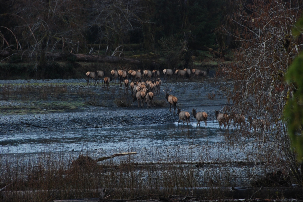
The park hosts Roosevelt elk, black bears, mountain lions, and over 300 bird species. The elk are most visible in the Hoh Valley and along the Quinault River. Salmon run in the Sol Duc River in late summer and early fall - you can watch them leap at Salmon Cascades from a viewing platform. Tidepooling on the coast reveals sea stars, anemones, and crabs. The park's wildlife viewing opportunities are best in early morning and late evening, when animals are active and crowds are thin.
Beach Exploration
The Olympic coast is not a swimming beach. The water is cold year-round, the rip currents are dangerous, and the logs piled on the shoreline can shift without warning. What it offers instead is raw coastal beauty - sea stacks rising from the surf, tidepools teeming with life, and a sense of isolation that few developed beaches can match. Kalaloch Beach is the most accessible. Beach 4 has excellent tidepooling. Ozette offers a 3-mile boardwalk trail to the coast.
Snow Play
Hurricane Ridge becomes a winter recreation area when snow accumulates. Cross-country skiing, snowshoeing, and tubing are all available. The road closes frequently in winter storms, so check conditions before driving up.
For a full breakdown of activities, see the tours and guided experiences page.
Where to Stay
Campgrounds
The park operates 12 front-country campgrounds, and they vary enormously in size, elevation, and character. Here is the honest breakdown:
Kalaloch Campground (170 sites, $24/night) - The only oceanside campground that takes reservations. Some sites overlook the Pacific. Book months ahead for summer.
Hoh Campground (78 sites, $24/night) - In the rainforest, with riverside sites and summer ranger programs. First-come, first-served. The lot fills by noon in summer.
Fairholme Campground (88 sites, $24/night) - On Lake Crescent. Lakeside sites available. Boat launch nearby. First-come.
Heart O' the Hills (97 sites, $24/night) - Nearest to Hurricane Ridge. Old-growth forest setting. Summer ranger programs. First-come.
Deer Park Campground (14 sites, $15/night) - At 5,400 feet, with mountain views and dark skies. The access road is steep, narrow, and gravel. No RVs. First-come.
Ozette Campground (15 sites, $20/night) - Lakeside, small, quiet. Near the Ozette Triangle trailhead.
South Beach Campground (55 sites, $15/night) - On a bluff above the ocean. Windswept. Beautiful. No reservations.
Mora Campground (sites vary) - Near Rialto Beach. Coastal forest setting. First-come.
North Fork, Queets, and Graves Creek - Small, remote, and affected by road conditions. Check alerts before heading to these.
For a detailed breakdown of each campground, including site recommendations and reservation strategies, see the full camping options guide.
Lodging
Inside the park, Lake Crescent Lodge, Kalaloch Lodge, and Sol Duc Hot Springs Resort offer cabins and rooms. These book out months in advance. The lodging and accommodations page has specifics on each property and booking strategies.
Gateway Towns
Port Angeles is the largest and most practical home base, with hotels, grocery stores, gear shops, and restaurants. Forks is closer to the coast and rainforest but smaller. Aberdeen and Hoquiam sit at the peninsula's southern edge. If you cannot find camping inside the park, the national forest land surrounding it has additional options.

Practical Takeaways
- You cannot see the whole park in one day. Most visitors underestimate driving times. Port Angeles to Hoh is two hours. Hoh to Kalaloch is one hour. Build your itinerary around one region per day.
- The Hoh parking lot fills by 10 AM. If you arrive later, you will park on the road shoulder or turn around. Early morning is your best bet for a space.
- Coastal camping is windy. Kalaloch and South Beach sit on bluffs exposed to the Pacific. Stake your tent well and bring earplugs.
- The rainforest is not always raining. July through September, the Hoh Valley gets less precipitation than Seattle. July and August are genuinely dry. Pack for it anyway.
- Cell service drops out at the Hoh, the coast, and most of Quinault. Download your maps, directions, and reservation confirmations before you leave town.
- Kalaloch is the only campground that takes reservations. Everything else is first-come, first-served. Arrive early or have a backup plan.
- The Hurricane Ridge Road closes without warning. Weather conditions change fast at 5,200 feet. Check the road status before driving up.
- The tidepooling is best at low tide. Check tide tables for the coast. Negative tides expose the most life. Beach 4 and Kalaloch are reliable spots.
- Mountain snow lingers into July. Trails above 4,000 feet can have snow crossings through early summer. Bring trekking poles and check trail conditions at the visitor center.
- The park is open 24 hours, but the gates to specific areas are not. The Hoh Road, the Hurricane Ridge Road, and the roads to most trailheads close at night. You cannot sleep in your car at a trailhead parking lot.
Final Thoughts
Olympic National Park is not a place you check off in a weekend. It asks for patience - patience with the driving, the rain, the crowds at the trailheads you wanted to yourself. What it gives back is the experience of standing in a temperate rainforest at noon and hearing nothing but dripping water and bird calls, or watching the sunset paint the sea stacks at Kalaloch, or looking down from Hurricane Ridge at an ecosystem that stretches from the alpine zone to the coast. It is a park for people who want to understand how many ways a landscape can be alive. If that sounds like you, start planning now. The campgrounds fill up fast.
For more information, see our complete National Park Guide.
Recommended Gear
What experienced visitors bring to Olympic National Park: Rainforests, Peaks & Wild Coast - 2026 Guide
Links may earn us a commission at no extra cost to you. We only recommend gear we believe in.
Hiking Essentials
Hydration Pack (3L)
Hands-free water for long trail days
Trekking Poles (Pair)
Save your knees on steep descents
Hiking Boots (Ankle Support)
Sturdy footwear for rocky, uneven trails
Sun & Heat Protection
Wide-Brim Sun Hat
Full coverage UPF 50+ protection at altitude
Insulated Water Bottle (32oz)
Keeps water cold in desert heat all day
Winter Gear
Microspikes / Traction Devices
Essential for icy rim trails in winter months
Packable Down Jacket
Lightweight warmth that stuffs into a pocket
Sources
- Official source: NPS — Olympic National Park nps.gov/olym/index.htm
Explore More National Parks

Mount Rainier National Park: Wildflowers, Glaciers & Cascade Views - 2026 Guide
Discover wildflowers, glaciers, and Cascade views. Complete 2026 guide to Mount Rainier National Par...

North Cascades National Park: America's Alps & Glacier Wilderness - 2026 Guide
Discover America's Alps — glacier wilderness and remote North Cascades. Complete 2026 guide to North...

Crater Lake National Park: America's Deepest Lake - Complete 2026 Guide
Crater Lake National Park: America's Deepest Lake - Complete 2026 Guide Introduction Seventy-seven c...

Glacier National Park: Going-to-the-Sun Road & Complete 2026 Guide
Discover the Going-to-the-Sun Road and 700 miles of trails. Complete 2026 guide to Glacier National...
Photo Gallery
More to Explore

Park Guide
Acadia National Park: Carriage Roads, Cadillac Mountain & 2026 Guide
Discover carriage roads, Cadillac Mountain, and rugged Maine coast. Complete 2026 guide to Acadia National Park — trails, fees, lodging, permits, and what rangers recommend.

Hiking Guide
Grand Canyon Hiking Trails: Day Hikes, Water Sources & Rim to Rim
Compare Grand Canyon hiking trails: Bright Angel, South Kaibab, Hermit, Grandview, and rim to rim, with distances, elevation, water stops, and trailhead access for each.

Best Of
Best of Glacier Bay National Park
The best of Glacier Bay is reached by boat: ranger-led day tours up the bay to the tidewater glaciers. What's worth it, how to book, and when to go (2026).

Campsite Guide
White Sands Backcountry Camping: Closed for 2026 — What to Know
As of 2026, backcountry camping at White Sands National Park is closed for site rehabilitation. What that means, and where to camp nearby instead.

Weather Guide
Guadalupe Mountains National Park Weather: Weather
Guadalupe Mountains National Park: weather guide guide updated 2026. Practical visitor information, reservations, and seasonal tips worth bookmarking before

Best Of
Best of Cuyahoga Valley National Park: Best Things to Do
Seeing a Cleveland Orchestra concert with the woods as your backdrop is a uniquely Cuyahoga Valley experience.
Sign in to join the conversation.
Sources & Attribution
Location data courtesy of the National Park Service (U.S. Department of the Interior). NPS data is public domain. Official NPS page.
Images: NPS; NPS; NPS; NPS; NPS.
Map data © OpenStreetMap contributors.
Park operations alerts: NPS.gov · Weather and weather hazards: National Weather Service · Live conditions.
Information may change. Always verify fees, hours, and conditions directly with the official source before visiting.
Did this guide help? Share it with a friend.