Seventy-seven centuries ago, Mount Mazama stood 12,000 feet tall in the Cascade Range. Then it erupted, collapsed into itself, and left behind a caldera that fills with rain and snow every year. The result is Crater Lake - 1,943 feet deep, fed by no rivers or streams, and so pure that scientists measure water clarity at over 100 feet in summer. When travelers search for national parks near Crater Lake in southern Oregon, they're usually looking for this one specifically, and for good reason: no other lake in North America combines this depth, this color, and this geology in one place.
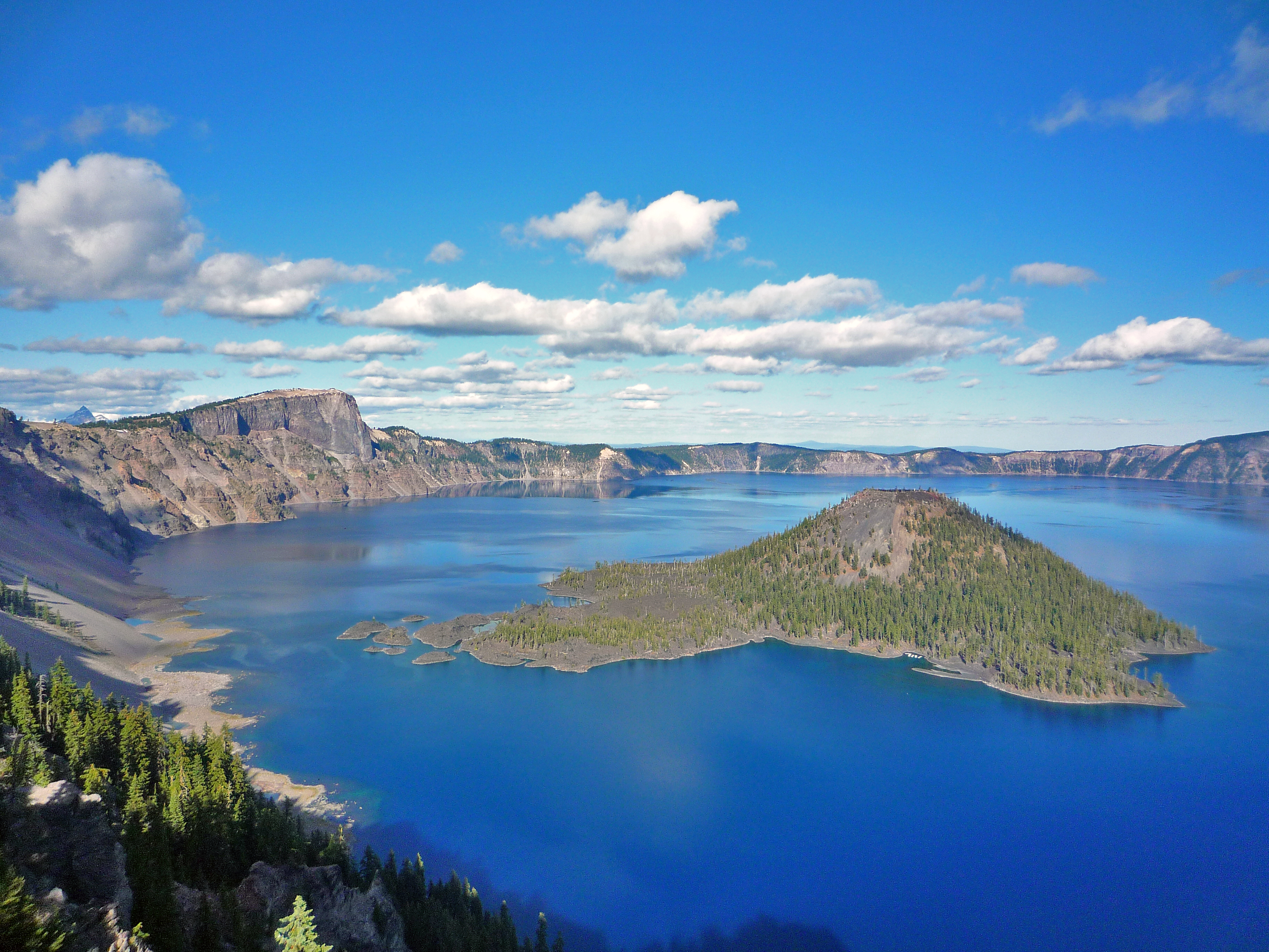
NPS via NPS.gov (Public Domain)
Crater Lake National Park: America's Deepest Lake - Complete 2026 Guide
11 min read
Park Guide
Discover Crater Lake National Park, America's deepest lake at 1,943 feet. Learn about its stunning blue water, Rim Drive, and best times to visit in this 2026 guide.
Your plans
This article contains affiliate links — we may earn a small commission at no extra cost to you.
At a glance
Entrance Fee
Private vehicle $30 · Private vehicle $20 · Motorcycle $25Full fee schedule
Hours
Crater Lake National Park is open year-round, 24 hours a day. Some roads, trails, and facilities, ho
Best Time
June-September (summer), September-October (fall colors)
Address
Crater Lake National Park, Crater Lake, OR, 97604
Website
42.9407, -122.1338
Google MapsThe color is what stops most people first. That deep, saturated blue comes from the water's purity - almost no sediment, algae, or pollutants to scatter light. It hits you as a shock the first time you see it from Rim Village, especially if you've driven through forest for the last hour with no hint of what's coming. The lake is invisible from the approach roads. You arrive, walk maybe fifty feet from your car, and the entire caldera opens beneath you.
What the park website doesn't mention is how often the lake simply isn't visible. Winter clouds cover it roughly half the time from November through April. Even in summer, afternoon haze or distant wildfire smoke can mute the color. Early morning is your best bet for the clearest water and the least crowd. By 10 AM in July, the main viewpoints have a line.
The Lay of the Land
Crater Lake National Park is not large by national park standards - roughly 183,000 acres - but its layout is simple and dictated by the caldera at its center. Almost everything worth seeing relates to the lake itself.
The park divides into three practical zones:
Rim Village sits on the southwest edge of the caldera at roughly 7,100 feet elevation. This is the nerve center: Crater Lake Lodge, the Rim Visitor Center, Sinnott Memorial Overlook, the gift shop, and the primary parking concentration. From here, Rim Drive heads clockwise or counterclockwise around the lake. Most first-time visitors start here and should.
Mazama Village lies about 7 miles south of Rim Village on Highway 62, at lower elevation. This is where you'll find Mazama Campground, the Cabins at Mazama Village, the only gas station in the park (closed for the season as of late 2026 - more on that below), and the Annie Creek area. Many visitors staying inside the park base themselves here rather than at the more expensive Crater Lake Lodge.
The Panhandle refers to the narrow southern extension of the park along Highway 62, where you'll find Ponderosa Picnic Area at 4,400 feet - the lowest elevation in the park. This area sees far fewer visitors. The Pinnacles, a set of volcanic spires formed by gas vents in pyroclastic flows, sit on the park's east side and require a separate drive on a dead-end road off the East Rim Drive.
Driving from the South Entrance to Rim Village takes about 20 minutes. From the West Entrance, roughly 30 minutes. The North Entrance Road and most of Rim Drive close from November through June or July, depending on snowpack. As of early 2026, the North Entrance Road and Rim Drive are closed for the season and will not reopen until mid-to-late June or July.
Planning Your Visit
Entrance Fees
As of 2026, the summer rate (mid-May through October) costs $30 per private vehicle. The winter rate (November 1 through mid-May) drops to $20. Motorcycles pay $25 in summer, $15 in winter. Walk-ins and bicyclists pay $15 per person. Youth 15 and under enter free. The America the Beautiful pass covers entry. Snowmobilers entering on the snow-covered North Entrance Road pay $15 per person.
Hours of Operation
The park is open 24 hours a day, year-round. The West and South Entrances on Highway 62 stay open all year. The North Entrance closes in winter, typically from November 1 through late June. As of 2026, it's scheduled to reopen around June 25, but snow conditions can push that later.
The Rim Visitor Center and Steel Information Center have seasonal hours. Steel Information Center recently reopened after structural renovations. Hours for Sinnott Memorial Overlook run late June to mid-October.
Best Time to Visit
July through September offers the most reliable warm, dry weather and full access to Rim Drive. May, June, and October bring mixed conditions - sunny days alternating with rain or snow. The lake can be invisible for days at a stretch. November through April means deep snow (an average of 41 feet per year at park headquarters), closed roads, and a completely different park experience centered on snowshoeing and cross-country skiing. For a dedicated look at seasonal conditions, check the best time to visit guide.

Getting There & Getting Around
Directions
From the west (Medford): Take Highway 62 to the West Entrance. Open year-round. This is the most common approach for visitors flying into Medford's Rogue Valley International Airport, about 90 minutes away.
From the south (Klamath Falls): Take Highway 97 north to Highway 62 to the South Entrance. Also open year-round. Klamath Falls sits about 60 minutes south.
From the north: The North Entrance on Highway 138 is summer-only. Winter travelers from Roseburg take Route 138 east to Route 230 south to Route 62 east to the West Entrance. Travelers from Bend take Route 97 south to Route 62 to the South Entrance.
Parking
Rim Village parking fills early - typically by 9:30 or 10 AM in July and August. The lot has maybe 200 spaces, and tour buses take several of them. If the lot is full, your options are limited. The park has no shuttle system. You can drive down to Mazama Village and hope for a spot later, or arrive before 8 AM and leave by early afternoon when the crowds peak.
Cell Service
Cell service drops out at multiple points along Rim Drive and is nonexistent in the caldera itself. The Rim Village area has spotty service from some carriers. Steel Information Center has a public phone. Download maps and directions before you arrive.
What to Do
Scenic Rim Drive
The Rim Drive is the park's primary experience - 33 miles of lake views, panoramic vistas, forests, and meadows. The road was designed in the 1930s specifically to follow the caldera's contours, so it curves constantly and offers something different at every turn. Allow 1 to 3 hours for a full loop without stops, but count on longer. Most visitors take 3 to 4 hours minimum with photo stops and short walks.
Key pullouts include Phantom Ship Overlook (one of two islands in the lake, best seen in early morning when the low sun lights it from behind), Pumice Desert (a flat, barren expanse of pumice from the eruption 7,700 years ago), and the Pinnacles overlook on the east side.
Hiking and Trails
The hiking here is limited compared to parks with extensive trail networks, and that's by design - much of the park is steep caldera walls or deep forest. But the trails that exist are excellent. The Cleetwood Cove Trail - the only legal access to the lake shore - is closed for rehabilitation as of 2026. This is a major change. If you want to touch the water, check the park's construction updates. The Castle Crest Wildflower Trail (.041 mile loop) offers a short walk through a spring-fed meadow with abundant flowers in early summer. For a broader look at what's available, see the full hiking trails guide.
Biking
Cycling Rim Drive has grown in popularity each year. It's 33 miles around with significant elevation change - roughly 3,800 feet of total climbing. Strong riders can do the loop in 3 to 4 hours. The road is narrow in sections, and vehicle traffic shares it. Early morning is your best bet for fewer cars. The season runs summer through fall, once the snow clears from the road.
Snowshoeing and Winter Sports
Winter transforms the park. West Rim Drive closes to vehicles on November 1 and becomes the most popular ski and snowshoe route in the park. Snowshoeing requires no special skill - you strap on a pair and follow the road or marked routes. Rangers lead guided snowshoe walks. Cross-country skiing is also popular. The Rim Village area becomes a winter hub for sledding, photography, and snow play.
Boat Tours
When Cleetwood Cove Trail is open (not in 2026 due to construction), boat tours run from the marina to Wizard Island - a cinder cone that rises from the lake itself. The tours are popular and tickets sell out. If the trail reopens in future seasons, book ahead.
Other Activities
The park supports ranger-led programs, Junior Ranger activities, night sky viewing (excellent - minimal light pollution), fishing (native Kokanee salmon and rainbow trout), and wildlife watching. Birders should watch for peregrine falcons and Clark's nutcrackers. Elk and black bears are present but not guaranteed. For a deeper look at park fauna, see the wildlife viewing guide, and for guided experiences, check tours and guided experiences.

Where to Stay
Campgrounds
Mazama Campground offers 214 sites at $35 per night. It opens in June and closes in late September. Each site accommodates tents and RVs, but there are no hookups. The campground sits at about 6,000 feet elevation, so nights are cool even in August. Reservations are recommended - walk-up sites exist but fill fast.
Lost Creek Campground (16 sites, $5 per night) is closed all year in 2025 and may remain so into 2026. Check the park website before planning around it. It typically opens in early July and closes in mid-October when operational.
For a full rundown of where to pitch a tent or park an RV, see the camping options page.
Lodging
Crater Lake Lodge sits directly on the caldera rim. Open mid-May to early October. Rooms book far in advance - often a year ahead for summer weekends. The lodge is historic (built 1915) and shows it: rooms are modest, walls are thin, and the price is high. What you pay for is the view, and it delivers.
The Cabins at Mazama Village offer a more affordable alternative. Rustic exteriors, casual interiors, set among lodgepole pines. They're 7 miles from the lake but in a quieter setting with easier parking.
For a complete look at inside-park and gateway lodging, read the lodging and accommodations guide.
Gateway Towns
If everything inside the park is booked - which it often is - you'll be staying in Medford (90 minutes west), Klamath Falls (60 minutes south), or Bend (two hours northeast). Medford has the most options and a decent airport. Bend has better restaurants and breweries but a longer drive.
Seasonal Guide
Summer (July-September)
This is the window. Rim Drive is fully open. All entrances are accessible. Weather is warm (60s to 70s at lake level, occasionally hitting 80) and dry. Afternoon thunderstorms pop up in August but pass quickly. Crowds are heavy - expect lines at the visitor center and full parking lots by mid-morning. Make reservations for lodging and camping as early as possible.
Spring and Fall (May-June, October)
Unpredictable. You might get a perfect bluebird day in May or a snow squall in June. October brings crisp air, changing aspen and vine maple, and far fewer people. Some facilities are closed at the beginning and end of these windows. Rim Drive typically opens in segments - check conditions before planning a trip. The lake is visible maybe half the time during these shoulder months.
Winter (November-April)
This is a different park. The North Entrance closes. Rim Drive closes. Snow piles up - 41 feet average at park headquarters. The lake is invisible about 50% of the time. What draws people here in winter is the quiet. Snowshoeing and cross-country skiing replace scenic drives. Rim Village stays open for winter sports. Fewer than 10% of annual visitors come in winter. If you want solitude and don't mind cold (20s and 30s during the day, single digits at night), this is your season.

Practical Takeaways
- The gas station at Mazama Village is closed for the season as of late 2026. No gasoline is available anywhere in the park. Running out means calling a tow truck. Fill up in Medford, Klamath Falls, or Chemult before entering.
- The Cleetwood Cove Trail is closed for rehabilitation in 2026. You cannot reach the lake shore by foot. The boat tours are not operating. This affects every visitor who planned to touch the water. Plan accordingly.
- Arrive before 8 AM in summer or don't bother with Rim Village parking. The lot fills by 9:30 AM and doesn't clear until late afternoon. There is no overflow lot and no shuttle.
- The lake is invisible roughly half the time in winter. This is not a bug - it's the park's normal winter condition. If you come in January planning to photograph the lake, have a backup plan.
- Rim Drive is 33 miles but takes 3+ hours with stops. Don't treat it as a quick drive. The pullouts require walking, the viewpoints demand time, and the road is narrow with no shoulders in places.
- The North Entrance Road and Rim Drive are closed for the season as of early 2026. They reopen mid-to-late June or July depending on snow. Verify opening dates before assuming access.
- Cell service drops out on Rim Drive and in the caldera. Download everything - maps, directions, reservation confirmations - before you arrive. The visitor centers have limited connectivity.
- Roads can be icy even when the sun is shining. The park service specifically warns about this - ice patches form in shaded sections, especially mornings and evenings. Drive accordingly.
- The park has two entrances open year-round: West and South. The North Entrance is summer-only. Winter travelers from Roseburg or Bend need to approach via Highway 62.
- Book lodging and camping a year ahead for summer. Crater Lake Lodge, Mazama Cabins, and Mazama Campground fill far in advance. The park has limited capacity and no overflow beyond what's listed above.
Final Thoughts
Crater Lake National Park rewards the specific kind of visitor who plans carefully and arrives early. It is not a park you can improvise in July - the parking lots fill, the lodge books solid, and the road closes when snow arrives. But for the visitor who comes prepared, it offers something that no other national parks near Crater Lake in the region can match: a body of water so deep, so pure, and so singular in its origin that the experience of seeing it sticks with you.
Come for the color. Stay for the quiet. Leave wanting to return in a different season - because this is a park that changes entirely with the snow line.
For more information, see our complete National Park Guide.
Recommended Gear
What experienced visitors bring to Crater Lake National Park: America's Deepest Lake - Complete 2026 Guide
Links may earn us a commission at no extra cost to you. We only recommend gear we believe in.
Hiking Essentials
Hydration Pack (3L)
Hands-free water for long trail days
Trekking Poles (Pair)
Save your knees on steep descents
Hiking Boots (Ankle Support)
Sturdy footwear for rocky, uneven trails
Sun & Heat Protection
Wide-Brim Sun Hat
Full coverage UPF 50+ protection at altitude
Insulated Water Bottle (32oz)
Keeps water cold in desert heat all day
Winter Gear
Microspikes / Traction Devices
Essential for icy rim trails in winter months
Packable Down Jacket
Lightweight warmth that stuffs into a pocket
Sources
- Official source: NPS — Crater Lake National Park nps.gov/crla/index.htm
Explore More National Parks

Redwood National Park: Walking Among Earth's Tallest Trees - 2026 Guide
The Tall Trees Grove - home to the tallest measured trees on Earth - is here but requires a free per...

Coastal Trail: Complete 2026 Travel Guide & Visitor Information
There is no entrance fee to access the Coastal Trail or the tidepool parking lots. The park's tidepo...

Lassen Volcanic National Park: Boiling Springs & Active Volcanics - 2026 Guide
Lassen's park road opens only 4 months yearly. 2026 guide to snowmelt timing, campground openings, a...

Mount Rainier National Park: Wildflowers, Glaciers & Cascade Views - 2026 Guide
Discover wildflowers, glaciers, and Cascade views. Complete 2026 guide to Mount Rainier National Par...
Photo Gallery
More to Explore

Park Guide
Acadia National Park: Carriage Roads, Cadillac Mountain & 2026 Guide
Discover carriage roads, Cadillac Mountain, and rugged Maine coast. Complete 2026 guide to Acadia National Park — trails, fees, lodging, permits, and what rangers recommend.

Hiking Guide
Grand Canyon Hiking Trails: Day Hikes, Water Sources & Rim to Rim
Compare Grand Canyon hiking trails: Bright Angel, South Kaibab, Hermit, Grandview, and rim to rim, with distances, elevation, water stops, and trailhead access for each.

Best Of
Best of Glacier Bay National Park
The best of Glacier Bay is reached by boat: ranger-led day tours up the bay to the tidewater glaciers. What's worth it, how to book, and when to go (2026).

Campsite Guide
White Sands Backcountry Camping: Closed for 2026 — What to Know
As of 2026, backcountry camping at White Sands National Park is closed for site rehabilitation. What that means, and where to camp nearby instead.

Weather Guide
Guadalupe Mountains National Park Weather: Weather
Guadalupe Mountains National Park: weather guide guide updated 2026. Practical visitor information, reservations, and seasonal tips worth bookmarking before

Best Of
Best of Cuyahoga Valley National Park: Best Things to Do
Seeing a Cleveland Orchestra concert with the woods as your backdrop is a uniquely Cuyahoga Valley experience.
Sign in to join the conversation.
Sources & Attribution
Location data courtesy of the National Park Service (U.S. Department of the Interior). NPS data is public domain. Official NPS page.
Images: NPS; NPS; NPS; NPS; NPS.
Map data © OpenStreetMap contributors.
Park operations alerts: NPS.gov · Weather and weather hazards: National Weather Service · Live conditions.
Information may change. Always verify fees, hours, and conditions directly with the official source before visiting.
Did this guide help? Share it with a friend.