For more, see complete visitor guide.
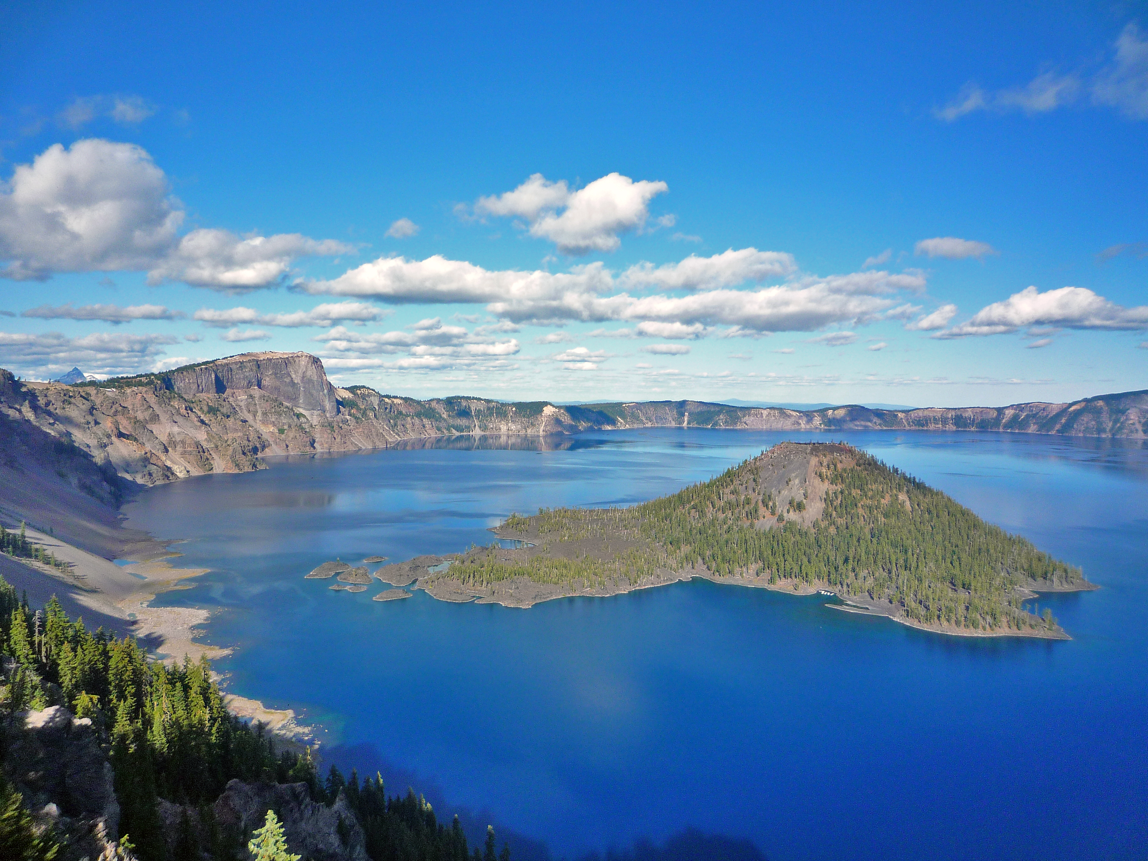
NPS via NPS.gov (Public Domain)
Hiking Crater Lake National Park
10 min read
Hiking Guide
Hike the rim or descend to the water at 7,000+ feet. Your 2026 guide to Crater Lake's short, spectacular hiking season and essential trails.
This article contains affiliate links — we may earn a small commission at no extra cost to you.
Hiking at Crater Lake comes down to two choices: the rim or the drop. You're either tracing the caldera's edge for those vertigo-inducing views into the blue, or you're making the committed descent to the waterline. The season here is brutally short—typically just July through early October—and entirely at the mercy of the snowpack. Most folks don't respect the altitude enough. The rim runs between 7,000 and 8,000 feet; that thin air will have you stopping on grades you'd handle easily back home. This isn't the park for lengthy, wandering backcountry routes. It's for potent, focused day hikes where each step offers a lesson in geology and a visual reward. For more on the park's story and other pursuits, our full guide has the details.
What Hiking Here Actually Means
Hiking here is a test of vertical gain and precise timing. Trails fall into two categories: deceptively taxing rim ascents or uncompromising drops straight to the lake. You won't find a gentle, level path skirting the shoreline—the caldera's architecture forbids it. Conditioning counts for more at Crater Lake than at most parks; what's listed as a 'moderate' three-mile trek typically packs a thousand feet of elevation gain at serious altitude.
First-time visitors consistently get two things wrong. They underestimate how quickly weather can change, going from sun to freezing wind in minutes. And they don't grasp that the Cleetwood Cove Trail, the only legal access to the lake shore, is a serious workout. It's a 2.2-mile round trip that feels much longer on the way back up. Success here means carrying more water than you think you need, starting hikes early to beat crowds and afternoon heat, and wearing footwear with aggressive tread for the loose pumice and rock.

Garfield Peak Trail: The Definitive Rim Hike
Distance: 3.4 miles round trip
Elevation Gain: 1,010 feet
Trailhead & Parking: The trail starts directly behind Crater Lake Lodge. The small lot at the lodge fills by 9 AM on a summer morning. Overflow parking is along Rim Drive, but that adds significant distance. Your best bet is to arrive before 8:30 AM or plan to use the park's shuttle when it's running.
The Trail: The path begins as a wide, crushed pumice track before narrowing into a series of tight switchbacks carved into the caldera wall. The exposure is constant and significant - there are long drop-offs with no guardrails. The trail narrows here, especially when passing other hikers. The final push to the summit is across an open, rocky slope where the wind is often fierce.
The Moment: Reaching the 8,054-foot summit and getting the unobstructed, 360-degree view. To the south, you see the entire lake basin; to the north, the Cascade Range stretches to the horizon.
What Most Underestimate: The wind chill at the summit, even on a warm day. The altitude gain happens steadily, and the lack of shade makes the return trip hotter than expected.
Best Time: Early morning, for calm air and soft light on the lake. Late afternoon can be spectacular, but afternoon thunderstorms are a real risk.
Cleetwood Cove Trail: The Only Way Down
Distance: 2.2 miles round trip
Elevation Gain: 700 feet (all on the return climb)
Trailhead & Parking: Located at Cleetwood Cove on the north side of Rim Drive, about 4 miles east of the North Junction. This is the single most popular trailhead in the park. The lot is often full by 10 AM, creating a line of cars parked along Rim Drive for nearly a mile. Rangers actively ticket those who park outside designated areas.
The Trail: This is a straightforward, steep descent on a wide, well-maintained but relentless series of switchbacks. The surface is compacted pumice and gravel. It's entirely exposed. There are no benches, no shade, and no water. You go down, you reach the small rocky shore and dock, and you turn around and climb back up.
The Moment: The shock of the water's temperature when you touch it - it's near freezing year-round. The color up close is even more intense.
What Most Underestimate: The difficulty of the climb back out. At a 10-15% grade, it's a sustained, lung-burning effort at high elevation. People in flip-flops or carrying coolers are a common, regrettable sight.
Best Time: Mid-morning, after any morning chill has burned off but before the midday sun bakes the trail. Note: As of 2026, this trail is CLOSED for a major rehabilitation project. Check the official website for reopening status before planning your trip.
Watchman Peak Trail: Short & Strategic
Distance: 1.6 miles round trip
Elevation Gain: 420 feet
Trailhead & Parking: Watchman Overlook parking area on Rim Drive's west side. The lot is modest and fills quickly. If full, the nearby Discovery Point trailhead can sometimes serve as overflow, adding a half-mile walk along the rim.
The Trail: A steady, switchbacking climb on a paved path that transitions to dirt and rock. It's shorter than Garfield but offers a similarly commanding view for less effort. The trail ends at a historic fire lookout perched on the rim.
The Moment: The view of Wizard Island perfectly framed by the caldera walls. It's the best vantage point for photographing the island's cinder cone shape.
What Most Underestimate: How crowded the small summit area can get. It's a bottleneck, especially at sunset.
Best Time: Sunset. The lookout faces west, providing a direct view of the sun setting over the lake and the Cascades.
Plaikni Falls Trail: A Forest Walk to Water
Distance: 2.0 miles round trip
Elevation Gain: Minimal, about 100 feet
Trailhead & Parking: A dedicated lot on the Pinnacles Road spur, off the East Rim Drive. It's less crowded than rim trailheads but still fills by late morning on weekends.
The Trail: A gentle, paved trail that winds through an old-growth hemlock and fir forest before ending at a viewing area for Plaikni Falls. It's the park's easiest significant hike and the best option for families or a leg-stretcher. The trail is accessible for strollers and wheelchairs for the first 0.8 miles.
The Moment: The cool, damp air at the falls grotto, a stark contrast to the dry rim. The water cascades over moss-covered rock.
What Most Underestimate: The temperature difference. It can be 10-15 degrees cooler in the shaded forest than on the rim.
Best Time: Any time of day, as it's mostly shaded. Late July and August see wildflowers along the edges.
Mount Scott Trail: The Highest Point
Distance: 5.0 miles round trip
Elevation Gain: 1,250 feet
Trailhead & Parking: At the end of the spur road near Lost Creek Campground, on the park's east side. This remote location means parking is rarely an issue, but the drive from Rim Village takes about 45 minutes.
The Trail: A consistent, grinding climb on a rocky, exposed trail to the park's highest point (8,929 feet). The final section involves some light scrambling over talus. The 360-degree view from the summit fire lookout is the most comprehensive in the park.
The Moment: Seeing Crater Lake in its entirety as a near-perfect circle from above. On clear days, you can see Mount Shasta to the south and the Three Sisters to the north.
What Most Underestimate: The isolation. You are far from any services, and afternoon thunderstorms build quickly over this peak.
Best Time: Early morning to avoid lightning risk. The road to the trailhead is one of the last sections of Rim Drive to open in July due to snow.
Annie Creek Canyon Trail: A Geology Lesson
Distance: 1.7-mile loop
Elevation Gain: 200 feet
Trailhead & Parking: Starts at the Mazama Village Campground amphitheater. Use the campground parking if not staying there; it's rarely full.
The Trail: A loop descending into the deep, narrow gorge of Annie Creek. The trail crisscrosses the creek on footbridges and showcases the park's volcanic ash and pumice layers in the canyon walls. It's shaded and cool.
The Moment: Looking straight up the 50-foot canyon walls from the bottom, feeling the cool, damp microclimate.
What Most Underestimate: How muddy and slick the trail can be, especially in spring and early summer from snowmelt.
Best Time: A good hot-day hike, as it's almost entirely shaded. Best from late June onward, as snow lingers in the canyon.

Seasonal Trail Conditions
Your hiking window is narrow. Rangers start plowing Rim Drive in April, but most trails aren't hikeable until the snow melts, which can be as late as early July in a heavy year.
June: A gamble. The West and South Entrances are open, but Rim Drive often isn't fully cleared until late June or early July. Expect significant snow patches on all trails above 7,000 feet. Microspikes are still useful. The Cleetwood Cove trailhead area is usually one of the last to clear.
July: The park opens up. Rim Drive typically opens fully by early July, but the Mount Scott trailhead road may lag a week or two behind. Wildflowers begin at lower elevations. Afternoon thunderstorms become frequent - be off high points like Garfield Peak or Mount Scott by 1 PM.
August: Prime time. All trails are generally snow-free and dry. This is also the busiest month. Start your hike by 7:30 AM to secure parking and enjoy quiet trails. Mosquitoes can be pesky in forested areas like Annie Creek early in the month.
September: The best month for hiking crater lake national park. Crowds diminish after Labor Day, the weather is stable, and fall colors start in the hemlock and maple groves. Nights get cold. The park's shuttle service usually ends by mid-September.
October: A hard closure approaches. Snow can fall any time. The North Entrance and Rim Drive close for the season on November 1, or earlier with significant snow. Hiking is possible in early October, but be prepared for winter conditions to arrive suddenly.

Trailhead Logistics
Parking strategy is half the battle. The lots at Rim Village (Garfield Peak, Discovery Point) and Cleetwood Cove are the first to fill, often by 9 AM. The park operates a free shuttle along Rim Drive in July and August - use it. It stops at all major trailheads and viewpoints.
Cell service drops out at the park boundaries. There is no reliable cellular signal anywhere on Rim Drive or at trailheads. Assume you will be offline.
Water sources on trail are non-existent. There is no potable water available at any trailhead except Rim Village and Mazama Village. You must carry all the water you will need for your entire hike from the start.
There is no bear canister requirement for day hikes. For overnight backcountry hiking (which requires a permit), a bear-resistant food container is mandatory and can be borrowed from the visitor center.
For current trail conditions, stop at the Steel Visitor Center at Park Headquarters or the Rim Village Visitor Center. Rangers post daily updates on snow, mud, and hazards.

What to Carry
Forget generic lists. The terrain here demands specific gear.
Footwear: Trail runners or hiking boots with aggressive lugs. The pumice dust is like walking on tiny ball bearings - it's slick. Smooth soles are a liability.
Water: Carry a minimum of one liter per person for every two hours of hiking. For Cleetwood Cove, that's at least two liters per person. More if it's hot. Hydration reservoirs are easier than bottles for the constant sipping the altitude demands.
Layers: A windproof and waterproof shell is non-negotiable, even in August. The temperature difference between a sunny trailhead and a windy summit can be 30 degrees. A warm hat and gloves have saved many a summit photo op.
Traction: Microspikes in your car from October through June. In July, check at the visitor center - you might still need them for patchy snow on north-facing slopes.
Sun Protection: The UV radiation at 8,000 feet is intense. A wide-brimmed hat, sunglasses, and mineral-based sunscreen are essential. The pumice reflects light from below.
Navigation: A physical map. Cell service is absent, and while trails are well-marked, having a map of Rim Drive and trail junctions is prudent.
Practical Takeaways
- Altitude is real. You will get winded faster. Plan shorter days than you would at lower elevations and drink twice as much water.
- The Cleetwood Cove Trail closure as of 2026 is a major disruption. Verify its status before you plan your trip. Do not assume you can swim in the lake.
- Parking is a 9 AM game. If you're not at your desired trailhead by then, have a backup plan or be prepared to use the shuttle.
- There is no gas in the park. Fill up in Chemult, Chiloquin, or Prospect before entering. Running out of gas requires an expensive tow.
- Rim Drive is a seasonal road. It's typically fully open only from early July to late October. Your best time to visit for hiking is squarely within that window.
- Check the webcams on the park website before you drive. The lake is completely invisible about 50% of the time in winter and can be shrouded in fog on summer mornings. Don't waste a trip.
- The only camping in the park is at Mazama Campground. It often books up months in advance. For last-minute trips, research camping options in the surrounding national forest.
- Leave the flip-flops at the lodge. They are inappropriate and dangerous on every trail listed here.
- Afternoon thunderstorms are a genuine hazard in July and August. Be off peaks and ridgelines by early afternoon.
- The gift shop sells water for $4 a bottle. Bring your own.
Recommended Gear
What experienced visitors bring to Hiking Crater Lake National Park
Links may earn us a commission at no extra cost to you. We only recommend gear we believe in.
Hiking Essentials
Hydration Pack (3L)
Hands-free water for long trail days
Trekking Poles (Pair)
Save your knees on steep descents
Hiking Boots (Ankle Support)
Sturdy footwear for rocky, uneven trails
Sun & Heat Protection
Wide-Brim Sun Hat
Full coverage UPF 50+ protection at altitude
Insulated Water Bottle (32oz)
Keeps water cold in desert heat all day
Winter Gear
Microspikes / Traction Devices
Essential for icy rim trails in winter months
Packable Down Jacket
Lightweight warmth that stuffs into a pocket
Sources
- Official source: NPS — Crater Lake National Park nps.gov/crla/index.htm
Photo Gallery
More to Explore

Park Guide
Acadia National Park: Carriage Roads, Cadillac Mountain & 2026 Guide
Discover carriage roads, Cadillac Mountain, and rugged Maine coast. Complete 2026 guide to Acadia National Park — trails, fees, lodging, permits, and what rangers recommend.

Hiking Guide
Grand Canyon Hiking Trails: Day Hikes, Water Sources & Rim to Rim
Compare Grand Canyon hiking trails: Bright Angel, South Kaibab, Hermit, Grandview, and rim to rim, with distances, elevation, water stops, and trailhead access for each.

Best Of
Best of Glacier Bay National Park
The best of Glacier Bay is reached by boat: ranger-led day tours up the bay to the tidewater glaciers. What's worth it, how to book, and when to go (2026).

Campsite Guide
White Sands Backcountry Camping: Closed for 2026 — What to Know
As of 2026, backcountry camping at White Sands National Park is closed for site rehabilitation. What that means, and where to camp nearby instead.

Weather Guide
Guadalupe Mountains National Park Weather: Weather
Guadalupe Mountains National Park: weather guide guide updated 2026. Practical visitor information, reservations, and seasonal tips worth bookmarking before

Best Of
Best of Cuyahoga Valley National Park: Best Things to Do
Seeing a Cleveland Orchestra concert with the woods as your backdrop is a uniquely Cuyahoga Valley experience.
Sign in to join the conversation.
Sources & Attribution
Location data courtesy of the National Park Service (U.S. Department of the Interior). NPS data is public domain. Official NPS page.
Images: NPS; NPS; NPS; NPS; NPS.
Map data © OpenStreetMap contributors.
Park operations alerts: NPS.gov · Weather and weather hazards: National Weather Service · Live conditions.
Information may change. Always verify fees, hours, and conditions directly with the official source before visiting.
Did this guide help? Share it with a friend.