For more, see hiking trails, camping options, lodging and accommodations, best time to visit, and tours and guided experiences.
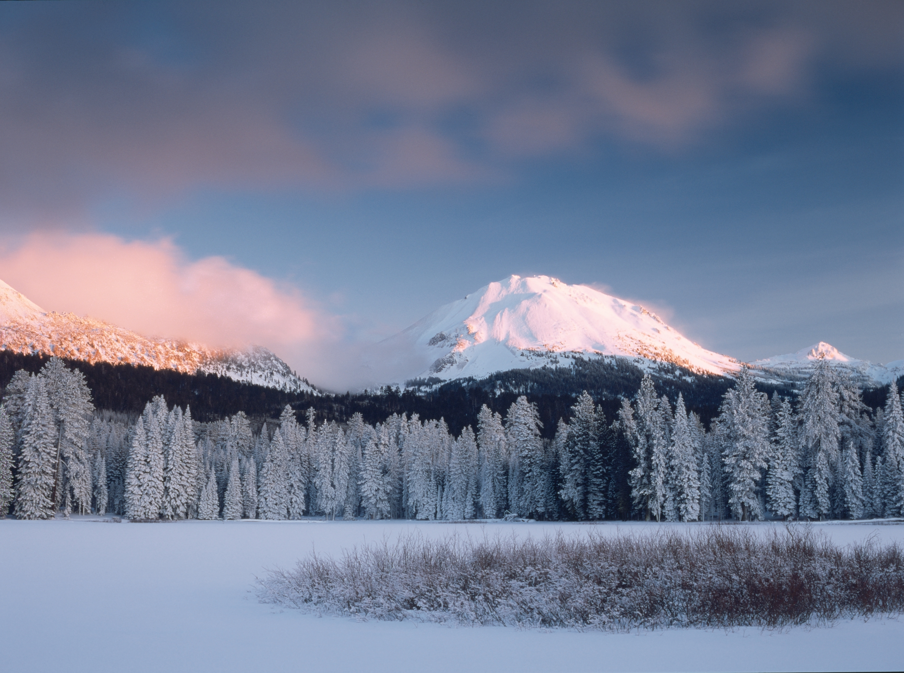
NPS via NPS.gov (Public Domain)
Lassen Volcanic National Park: Boiling Springs & Active Volcanics - 2026 Guide
16 min read
Places & Points of Interest
Lassen's park road opens only 4 months yearly. 2026 guide to snowmelt timing, campground openings, and where to camp before the highway clears.
Your plans
Overview
The park road at Lassen Volcanic opens fully for only about four months each year. Snow depths at higher elevations can hit 30 feet, and Highway 89—the main route through the park—usually doesn't clear until late May or early June. By November, it's buried again.
Camping here means working with a short window. Campgrounds open in stages, road closures shift week by week, and a June trip versus an August trip changes what you can actually reach. Time it right, and you'll find one of the most underrated parks in the Lower 48—where you can smell hydrogen sulfide from boiling mud pots one minute and stand on a cinder cone summit the next.
Lassen Volcanic is the centerpiece of a region that has produced every known type of volcanic eruption in the contiguous United States. Steam vents, hot springs, mud pots, and fumaroles are spread throughout the park, and Lassen Peak itself erupted as recently as 1917. The park is still geologically active - you'll hear the hiss of steam escaping from underground before you see it. The hiking trails here range from short boardwalk loops to 17-mile backcountry routes, and the lakes are cold enough in July to make you reconsider swimming.
Quick Information
- Entrance Fee: $30 per private vehicle (valid 7 days), $25 per motorcycle, $15 per person on foot or bicycle. Winter rate (typically November-May) drops to $10 per vehicle. America the Beautiful passes accepted.
- Hours: The park is always open. Road access is limited seasonally - typically November through May.
- Best Time to Visit: July through September for full road access. Late June is a gamble - Bumpass Hell Trail often stays closed through mid-July.
- Location: 38050 Highway 36 East, Mineral, CA 96063. About 50 miles east of Redding.
- Accessibility: Kohm Yah-mah-nee Visitor Center is fully accessible. Manzanita Lake area has accessible trails. Some geothermal boardwalks are wheelchair-friendly.
- Cell Service: Drops out at the park boundaries. Don't count on anything inside the park.
- Restrooms: Flush toilets at Manzanita Lake, Kohm Yah-mah-nee Visitor Center, and Southwest Walk-In Campground. Vault toilets at trailheads and other campgrounds.
- Parking: Manzanita Lake lot fills by 10 AM in July and August. Bumpass Hell trailhead parking is limited - arrive before 8 AM.

Getting There
From Interstate 5 (Redding), take Hwy 44 - 48 miles east to the junction of Hwy 89. Follow Hwy 89 south 1 mile to the north entrance of the park. From Interstate 5 (Red Bluff) take Hwy 36 E - 51 miles east to the junction of Hwy 89. Follow Hwy 89 north 6 miles to south entrance of the park.
The north entrance gives you quick access to Manzanita Lake and the Devastated Area. The south entrance gets you to Kohm Yah-mah-nee Visitor Center and the Sulphur Works area. If you're staying at one of the park campgrounds, which entrance you use matters - the park road is 30 miles long, and driving the full length takes about 45 minutes without stops.
In 2026, expect the main park road to open fully sometime between late May and mid-June, depending on snowpack. The Kohm Yah-mah-nee Visitor Center at the southwest entrance stays accessible year-round. The Devastated Area parking lot at the north end is also reachable in winter.
The roads to Juniper Lake and Warner Valley are closed for repairs as of 2026, with no estimated date for reopening. Check the park website before planning routes to those areas.
What to Expect
Lassen Volcanic is not Yosemite. There are no granite monoliths, no valley floor with a postcard view every hundred yards. What you get instead is a landscape that feels genuinely rough and unfinished - volcanic rock fields, meadows still recovering from the 2021 Dixie Fire, and the constant evidence that the ground beneath you is not done cooking.
The elevation range runs from about 5,600 feet at the southwest entrance to 10,457 feet at Lassen Peak's summit. That means the air is thin, the sun is strong, and afternoon thunderstorms are a regular occurrence from July through September. Temperatures in July average a high of 88°F and a low of 50°F, but those numbers don't tell you how fast the weather can shift. You can start a hike in short sleeves and need a jacket and rain shell two miles in.
The smell is the first thing most visitors notice. Hydrogen sulfide from the geothermal areas has a distinct rotten-egg odor that carries surprisingly far. You'll catch it at Sulphur Works from the parking lot. It fades as you move away from the vents, but it's a constant reminder that this is not a dormant landscape.
Winter is a different world entirely. January averages a high of 40°F and a low of 21°F. Snow blankets everything above 6,000 feet. The park gets an average of 164 days below freezing annually. Cross-country skiing and snowshoeing replace hiking. The roads close, and the park empties out to a handful of winter visitors.
The 2021 Dixie Fire burned through substantial portions of the park. You'll see the evidence - blackened trunks, open meadows where forest used to stand, and new growth pushing up through the ash. Rangers will tell you the fire changed the park's ecology in ways that are still unfolding. Some trails have been rerouted. Some areas remain closed. Keep an eye out for hazard trees and loose rock in burned zones.

Top Attractions & Points of Interest
Bumpass Hell
The largest hydrothermal area in the park and the one thing most first-time visitors have on their list. It's a 3-mile round-trip hike on a trail that climbs about 250 feet before dropping into the basin. The boardwalk loops past boiling pools, steam vents, and mud pots that bubble with the consistency of thick oatmeal.
Here's what the park website doesn't mention: Bumpass Hell Trail is often closed through mid-July due to snow. It's an annual closure, not a special condition. The snow lingers in the shaded sections, and the trail becomes dangerous with hidden ice and slippery boardwalks. Plan for late July or August if this is your priority.
The trail itself is exposed. There's almost no shade. Pack extra water for this stretch - two liters minimum. The boardwalk can get crowded by late morning, with people stopping to take photos and blocking the flow. Start early.
From this overlook you can see the full extent of the hydrothermal basin - steam rising from dozens of vents, the water in the pools an unnatural shade of turquoise that comes from dissolved minerals and heat-tolerant algae. The boardwalk keeps you at a safe distance. The ground here is unstable. Stay on the path.
Lassen Peak Trail
A 5-mile round-trip hike that gains 2,000 feet. It's the hardest day hike in the park and also the most rewarding. The trail switchbacks up the side of the peak, crossing talus fields and volcanic scree. The surface changes from packed dirt to loose rock about halfway up. Watch your footing on the transition.
Early morning is your best bet for this hike. The afternoon thunderstorms that roll through in July and August make the summit dangerous - lightning is a real risk above treeline. Start before 7 AM. Bring a jacket even if it's warm at the trailhead. The temperature drops noticeably as you climb, and the wind at the summit is constant.
The elevation gain is worth it. From the top, you can see Mount Shasta to the north, the Sacramento Valley to the west, and the entire Cascade Range curving away into Oregon. The crater at the summit is small - about 1,000 feet across - and still has steam vents on the northern side.
Most visitors underestimate the difficulty of this trail. It's only 5 miles, but the elevation gain and altitude (starting at 8,500 feet) make it feel longer. Allow 4-6 hours round trip.
Manzanita Lake
The most popular lake in the park, and for good reason. It sits right off the main road near the north entrance, has a flat 1.5-mile loop trail around it, and offers the classic reflection photo of Lassen Peak in the water. The lake is open for swimming, though the water stays cold even in August - expect temperatures in the 60s.
The campground here is the largest in the park and the most convenient for families. The general store sells basic supplies, ice, and firewood. The camper services building has coin-operated showers and laundry.
Early morning is your best bet for photos. The wind picks up by mid-morning and kills the reflection. By evening, the lake is usually rippled.
Sulphur Works
Right off Highway 89 near the southwest entrance. You can smell it before you see it. This is the easiest geothermal area to access - the vents and boiling mud pots are steps from the parking lot. It's not as dramatic as Bumpass Hell, but it's a good introduction to the park's volcanic activity.
The area has a short boardwalk loop with interpretive signs. The mud pots here are particularly active - they gurgle and pop constantly. The smell is strong. Most visitors spend 15-20 minutes before moving on.
Kings Creek Falls
A 2.3-mile round-trip hike to a 75-foot waterfall. The trail drops about 500 feet on the way down, which means you climb it all back on the return. The falls are at their best in late spring and early summer when snowmelt is running heavy. By late August, the flow drops significantly.
The trail passes through a meadow that's full of wildflowers in July - lupine, paintbrush, and mule's ears. The last section before the falls is steep and switchbacks down the canyon wall. There's a viewpoint platform at the bottom.
Devastated Area
A 0.5-mile interpretive trail that crosses the landscape flattened by the 1915 eruption of Lassen Peak. The trail is paved and wheelchair-accessible. Signs explain what happened when the volcano sent a lateral blast of hot gas and rock down this slope - similar to what Mount St. Helens would do 65 years later.
The trail is open year-round and is one of the few attractions accessible from the north entrance during winter. The parking lot is plowed.
Cinder Cone
In the northeast corner of the park, Cinder Cone is a 700-foot volcanic cone that last erupted in 1666. The trail to the summit is a mile long and gains 700 feet - the loose cinders make every step feel like you're sliding half of it back. The payoff is a view of the Painted Dunes, a landscape of multicolored volcanic ash deposits, and the Fantastic Lava Beds.
The road to the trailhead is unpaved and rough. The Butte Lake Campground area is the access point. In 2026, check road conditions before heading out - the Juniper Lake and Warner Valley road closures don't affect Butte Lake, but the dirt road can be rough after rain.
Activities
Hiking
The park has over 150 miles of trails. Hiking Lassen Volcanic National Park is the primary activity for most visitors, and the range of options is wider than you'd expect for a park this size. Short interpretive trails like Sulphur Works and Devastated Area take 15 minutes. Half-day hikes like Bumpass Hell and Kings Creek Falls take 2-3 hours. Full-day routes like Lassen Peak and Brokeoff Mountain take 4-6 hours. Backcountry routes like the Pacific Crest Trail segment through the park take multiple days.
The trail register at each trailhead is full of comments about trail conditions - check it before you start. Rangers will tell you that trail conditions change fast in this park. A trail that was clear in the morning can be snow-covered by afternoon on north-facing slopes.
For a complete list of options with distance, elevation gain, and difficulty ratings, see our guide to the best hiking trails in the park.
Boating and Paddling
Manzanita Lake allows non-motorized boats. Canoes, kayaks, and stand-up paddleboards are common. The lake is small enough to paddle across in 20 minutes, but the wind comes up in the afternoon and can make the return trip harder than expected. Butte Lake in the northeast is larger and less crowded - the dirt road access keeps the numbers down.
Fishing
The park's lakes and streams have rainbow and brown trout. A valid California fishing license is required. Manzanita Lake is the most accessible spot. Kings Creek and Hat Creek have sections open to fly fishing. The fishing is fine, not exceptional - these are high-elevation waters that don't produce trophy fish.
Winter Activities
Cross-country skiing and snowshoeing are available when the snow is deep enough - typically December through April. The park road becomes a 30-mile ski trail. The Kohm Yah-mah-nee Visitor Center rents snowshoes. The Lassen Chalet near the south entrance has ski rentals.
The road to Manzanita Lake is plowed, giving access to the lake loop for snowshoeing. The Devastated Area trail is also accessible.
Stargazing
Lassen Volcanic is a designated International Dark Sky Park. The light pollution is minimal - you can see the Milky Way clearly on moonless nights. The Manzanita Lake area is the easiest place to set up for night photography. The best viewing is August through October, when the skies are clearest and the nights are long enough for serious observation.

Seasonal Guide
Spring (April-May)
Snow lingers at all but the lowest elevations. The south entrance to Kohm Yah-mah-nee Visitor Center is accessible. The north entrance to Manzanita Lake is accessible. The park road between them is closed. Hiking is limited to low-elevation trails that melt out first - the Manzanita Lake loop, the Devastated Area interpretive trail.
Temperatures range from highs in the 50s to lows in the 30s. Bring waterproof boots. Mud is everywhere.
Summer (June-August)
The main window for most visitors. The park road typically opens fully in June. By July, the high country trails are mostly clear. August is the hottest month, with temperatures reaching 90°F or higher on about 37 days per year.
Crowds peak in July and August. Manzanita Lake Campground fills daily. The Bumpass Hell trailhead parking lot fills by 9 AM. Afternoon thunderstorms are regular - plan hikes for the morning.
This is the best time for camping in Lassen Volcanic National Park - all campgrounds are open (except Warner Valley and Juniper Lake, which are closed for road repairs in 2026).
Fall (September-October)
The best season if you want fewer people and stable weather. September has warm days and cool nights. The crowds thin out after Labor Day. The aspens and willows turn gold in the meadows.
By October, nights are below freezing. The first significant snow usually falls in late October or early November. The park road closes to through travel once the snow accumulates.
Winter (November-March)
The park is quiet. The road is closed past the visitor centers. Snow depth at higher elevations can exceed 20 feet. Cross-country skiers and snowshoers have the park to themselves. The Kohm Yah-mah-nee Visitor Center is open daily. The Lassen Chalet rents equipment.
Temperatures in January average a high of 40°F and a low of 21°F. The park sees 164 days per year below freezing. Avalanche danger exists in the backcountry.
Practical Information
Fees
As of 2026, a private vehicle entrance pass costs $30 and is valid for 7 days. Motorcycles are $25. Walk-ins and cyclists are $15. During winter (when the road is closed and services are limited), the fee drops to $10 per vehicle.
The America the Beautiful Annual Pass ($80) covers entrance for the pass holder and up to three additional adults. If you're visiting multiple national parks in a year, it pays for itself after three visits.
Camping
The park has seven campgrounds. Manzanita Lake is the largest with 179 sites and the only one that takes reservations. All others are first-come, first-served. Campgrounds near Lassen Volcanic National Park outside the park boundaries include several Forest Service campgrounds in Lassen National Forest - these are good backup options when the park fills.
Manzanita Lake Campground has flush toilets, coin showers, and a camp store. Sites are $26 per night. Reservations open six months in advance on recreation.gov and fill quickly for July and August.
Southwest Walk-In Campground has 20 tent-only sites near the Kohm Yah-mah-nee Visitor Center. It's a short walk from the parking lot. Vault toilets, no showers. $10 per night.
Butte Lake Campground has 18 sites in the northeast corner of the park. It's remote and quiet. Vault toilets, no water. $10 per night.
Warner Valley and Juniper Lake Campgrounds are closed for road repairs in 2026. Check the park website for updates.
For a full breakdown of sites, amenities, and reservation strategies, see our complete guide to camping options in the park.
Lodging
There are no hotels inside the park. The closest hotels near Lassen Volcanic National Park are in Mineral (about 10 miles from the south entrance), Chester (about 25 miles from the north entrance), and Redding (about 50 miles from the north entrance).
In Mineral, the Lassen Mineral Lodge has basic rooms and a restaurant. The Drakesbad Guest Ranch inside the park is a historic lodge with a hot spring-fed pool - it's operated by a concessionaire and books up months in advance. It's located in the Warner Valley area, which has road access issues in 2026.
For a complete list of lodging and accommodations near the park, check our lodging and accommodations guide.
Visitor Centers
Kohm Yah-mah-nee Visitor Center at the southwest entrance is open year-round. It has exhibits, a park film, a bookstore, and a cafe. The staff can answer questions about trail conditions and road status. The phone line is intermittent as of 2026 - email lavo_information@nps.gov if you can't get through.
Loomis Museum at Manzanita Lake is open seasonally (typically June through September). It has exhibits on the 1914-1917 eruptions and a small bookstore.
Supplies
The Manzanita Lake Camp Store sells basic groceries, ice, firewood, camping fuel, and souvenirs. The Kohm Yah-mah-nee cafe has food and drinks. For full groceries, gas, and supplies, stop in Redding or Chester before entering the park.

Safety & Preparation
Geothermal Hazards
The ground around hydrothermal features is unstable. The crust can be thin - people have fallen through into boiling water. Stay on designated trails and boardwalks. The signs are not decorative. The water in the pools can exceed 200°F.
Wildlife
Black bears are present in the park. Store food properly - bear-proof lockers are available at all campgrounds. Deer, raccoons, and squirrels are common. Mountain lions are present but rarely seen. Keep an eye out for them in the backcountry.
Weather
Afternoon thunderstorms are the primary safety concern in summer. Lightning strikes are a real risk on exposed peaks and ridges. Start hikes early and be off summits by noon. If you hear thunder, get below treeline immediately.
Snow can fall any month of the year at high elevations. Hypothermia is a risk even in August if you're not prepared for rain and wind.
The park averages 164 days below freezing per year. Even in July, the temperature can drop into the 40s at night.
Fire Safety
The 2021 Dixie Fire burned through parts of the park. Some areas remain closed. In open areas, hazards include fallen trees, loose rock, undefined trails, and hidden stump holes. Pay attention to closure signs.
Campfires are only allowed in designated fire rings in campgrounds. During high fire danger, fire restrictions may be in place. Check at the visitor center.
Water
Stream and lake water in the park contains giardia and other pathogens. Treat all water before drinking. Boil for one minute, use a filter rated for 0.3 microns or smaller, or use chemical treatment tablets.
Emergency Contacts
- Park emergency dispatch: 911
- Park headquarters: 530-595-6100 (intermittent phone service)
- Email: lavo_information@nps.gov
Insider Tips
- The Bumpass Hell trailhead parking fills by 8:30 AM in July. If you arrive later, you'll park along the road and walk an extra half mile. The alternative is to hike in from the Lake Helen parking area - it adds distance but avoids the parking stress.
- The best views of Lassen Peak are from Manzanita Lake in the morning and from the Devastated Area in the evening. The light hits differently at each spot, and the reflection photo at Manzanita Lake only works before the wind picks up around 9 AM.
- Bring cash for the first-come, first-served campgrounds. The fee tubes don't take cards, and cell service drops out at the park boundaries so digital payment apps won't work.
- The Kohm Yah-mah-nee Visitor Center cafe has decent food but limited hours. It closes by 4 PM most days. Don't count on it for dinner. Pack your own food.
- The Pacific Crest Trail passes through the park for about 18 miles. If you want a multi-day backpacking trip without the permit hassle of other parks, the PCT segment here is straightforward. Permits are required but easier to get than in Yosemite or Desolation Wilderness.
- The road to Butte Lake is unpaved and can be rough. It's about 6 miles of dirt road. After rain, it gets rutted. Passenger cars can usually make it, but take it slow.
- September is the best month for a visit. The crowds are gone, the weather is stable, the mosquitoes have died off, and the aspen trees are turning gold. The campgrounds are still open but rarely full on weekdays. For more on timing your trip, see our best time to visit guide.
- The park's Dark Sky status means serious stargazing opportunities. The Manzanita Lake area has the best accessible night sky views. The new moon in August and September offers the darkest conditions. Bring a red flashlight and a chair.
- If you want to see the park's volcanic features without the crowds, skip Bumpass Hell and go to Sulphur Works or the terminal geyser trail. They're less dramatic but also less crowded, and you get the same boiling mud and steam vents.
- The visitor center phone line is intermittent as of 2026. If you can't get through, email lavo_information@nps.gov. They respond within a few days.
For more information, see our complete National Park Guide.
Sources
- Official source: NPS — Lassen Volcanic National Park nps.gov/lavo/index.htm
Photo Gallery
More to Explore

Park Guide
Acadia National Park: Carriage Roads, Cadillac Mountain & 2026 Guide
Discover carriage roads, Cadillac Mountain, and rugged Maine coast. Complete 2026 guide to Acadia National Park — trails, fees, lodging, permits, and what rangers recommend.

Hiking Guide
Grand Canyon Hiking Trails: Day Hikes, Water Sources & Rim to Rim
Compare Grand Canyon hiking trails: Bright Angel, South Kaibab, Hermit, Grandview, and rim to rim, with distances, elevation, water stops, and trailhead access for each.

Best Of
Best of Glacier Bay National Park
The best of Glacier Bay is reached by boat: ranger-led day tours up the bay to the tidewater glaciers. What's worth it, how to book, and when to go (2026).

Campsite Guide
White Sands Backcountry Camping: Closed for 2026 — What to Know
As of 2026, backcountry camping at White Sands National Park is closed for site rehabilitation. What that means, and where to camp nearby instead.

Weather Guide
Guadalupe Mountains National Park Weather: Weather
Guadalupe Mountains National Park: weather guide guide updated 2026. Practical visitor information, reservations, and seasonal tips worth bookmarking before

Best Of
Best of Cuyahoga Valley National Park: Best Things to Do
Seeing a Cleveland Orchestra concert with the woods as your backdrop is a uniquely Cuyahoga Valley experience.
Sign in to join the conversation.
Sources & Attribution
Location data courtesy of the National Park Service (U.S. Department of the Interior). NPS data is public domain. Official NPS page.
Images: NPS; NPS; NPS; NPS; NPS.
Map data © OpenStreetMap contributors.
Park operations alerts: NPS.gov · Weather and weather hazards: National Weather Service · Live conditions.
Information may change. Always verify fees, hours, and conditions directly with the official source before visiting.
Did this guide help? Share it with a friend.