Volcanic cinder crunches underfoot, followed by the scent of sulfur on a breeze chilled by snowfields above. Hiking Lassen Volcanic National Park isn't a gentle forest stroll—it's a traverse across a landscape still cooling. You stand on a volcano's rim, feel a boiling mudpot's heat through your soles, and grasp what "active" means where the last eruption remains in living memory.
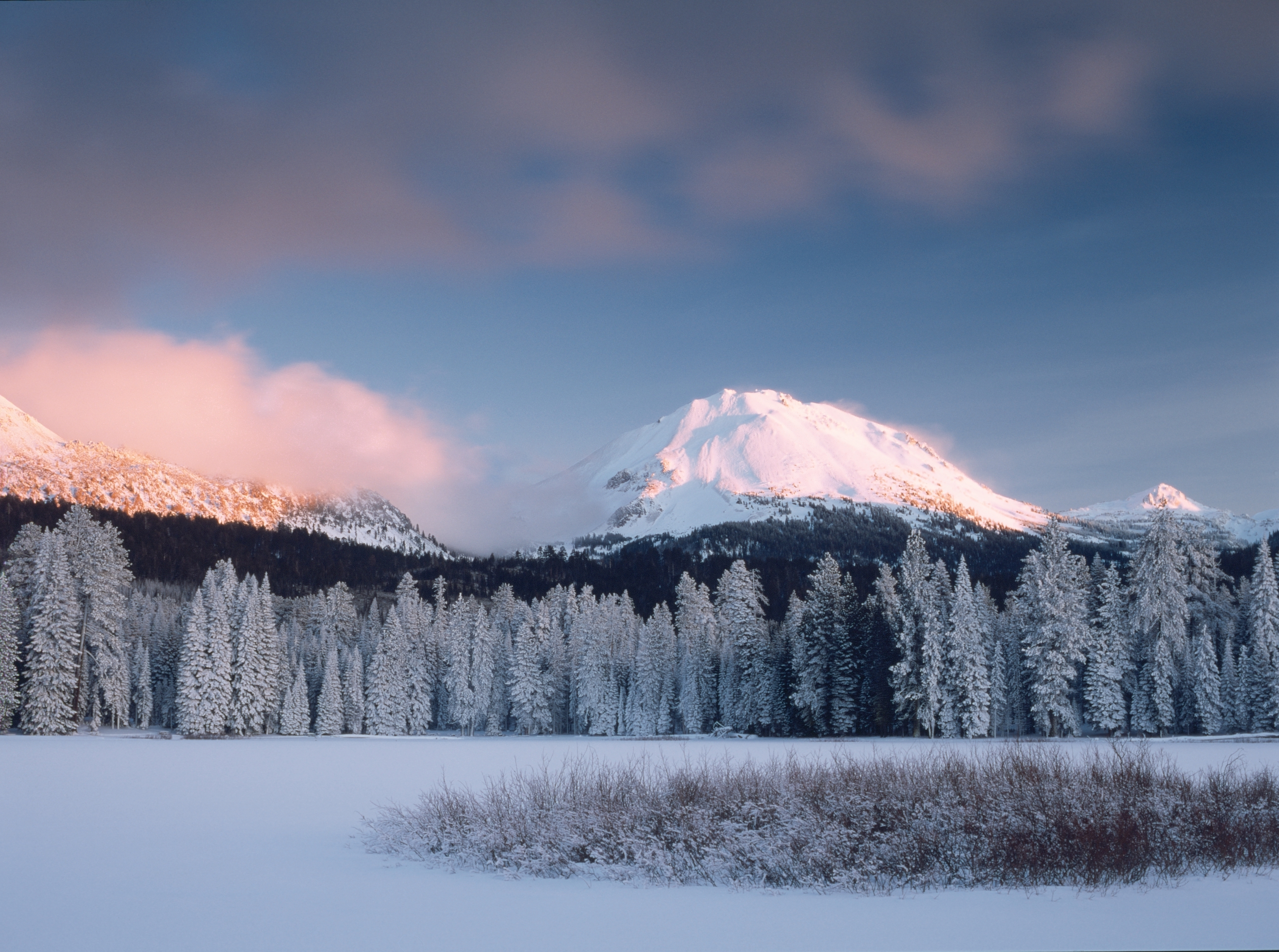
NPS via NPS.gov (Public Domain)
Hiking Lassen Volcanic National Park: Complete Guide (2026)
10 min read
Hiking Guide
The views of Lassen Peak reflecting in the lake's calm morning water are the park's most photographed scene. It's shared with anglers and families.
This article contains affiliate links — we may earn a small commission at no extra cost to you.
What Hiking Here Actually Means
Forget the manicured, graded paths of some parks. Hiking here means navigating terrain shaped by fire and ice. Trails climb over sharp, blocky lava rock, cross meadows still recovering from the 2021 Dixie Fire, and traverse steep slopes where snow lingers into July. The elevation - trailheads start around 6,500 feet - hits you harder than you expect. Most first-time visitors underestimate two things: how quickly the weather can shift from sun to a cold, wind-driven rain, and how much extra water they'll need in the thin, dry air.
In this park, your daypack must carry layers for all seasons, and checking the trail status board at the Kohm Yah-mah-nee Visitor Center isn't optional—it's essential. Rangers emphasize that the best hikes here require respecting the mountain's conditions.
Lassen Peak Trail: The Summit That Defines the Park
The one that answers the question "did I really hike a volcano?" with a definitive yes.
Distance: 5 miles round trip
Elevation Gain: 2,000 feet
Trailhead & Parking: The signed lot is on the east side of the Lassen Volcanic National Park Highway (CA-89), roughly 7 miles north of the Southwest Entrance. It fills by 8:30 AM on summer weekends. Overflow parking spills along the highway shoulders, adding a half-mile walk. The pit toilets here see heavy use.
The Trail: The path starts as a wide, crushed cinder track. That changes. After the first series of switchbacks, the surface becomes loose, gravelly volcanic scree that slides underfoot. The trail narrows here, with steep drop-offs on the east side. Above the tree line, you're fully exposed to sun and wind. The final push to the summit crater is across large, stable lava blocks. Watch your footing on the transition from scree to rock.
The Moment: Standing on the crater rim at 10,457 feet, looking down into the still-steaming vent while seeing Mount Shasta, 90 miles to the northwest, floating above the haze.
What Most Underestimate: The wind chill at the summit, even on a warm day. The sheer psychological grind of the switchbacks on the way down through the scree field. Your knees will have strong opinions.
Best Time: Start by 7 AM to avoid afternoon thunderstorms common in July and August. The trail is typically snow-free from late July through September.

Bumpass Hell Trail: The Park's Geothermal Heart
A boardwalk tour through a roaring, bubbling landscape that feels anything but hellish in the right light.
Distance: 3 miles round trip
Elevation Gain: 300 feet
Trailhead & Parking: The large lot is directly on CA-89, about 5 miles north of the Southwest Entrance. This is the park's most popular trailhead and is often full by 9 AM. There's a smaller overflow lot a quarter-mile south.
The Trail: A well-defined dirt path climbs gently through open terrain scarred by the Dixie Fire. The views are expansive but exposed. The final descent into the hydrothermal basin is via a series of short, steep switchbacks. The trail itself is closed annually by snow until mid-July or later - check the official website for current opening status. Once in the basin, you follow a wooden boardwalk that loops past boiling pools, roaring fumaroles, and bubbling mudpots.
The Moment: The first whiff of sulfur, followed by the sight of Big Boiler, one of the hottest fumaroles in the world, jetting a continuous plume of steam with a sound like a freight engine.
What Most Underestimate: The potency of the sulfur smell (it lingers on your clothes) and the sheer force of the steam vents. Stay on the boardwalk - the thin, brittle crust outside it can collapse into scalding water.
Best Time: Early morning or late afternoon, when the low sun lights up the steam plumes and the crowds thin. Avoid midday in summer when the basin can feel like a crowded sauna.
Cinder Cone Trail: A Walk on Another Planet
A relentless, sandy climb for a payoff that feels genuinely alien.
Distance: 4 miles round trip
Elevation Gain: 846 feet
Trailhead & Parking: Reach it via the unpaved Butte Lake Road from the north. The road is graded but dusty. The trailhead lot at Butte Lake is modest. If full, park carefully along the road leading in. This area is remote - no services, no cell service.
The Trail: The path skirts the edge of Butte Lake before crossing a flat, black lava bed known as the Fantastic Lava Beds. Then you see it: a perfect, 700-foot-tall symmetrical cone of loose volcanic cinder. The trail up its side is nothing but deep, sliding sand. For every two steps up, you slide one back. It's a grind. The final push involves a steep scramble on all fours.
The Moment: Reaching the rim and looking down into the deep, colorful crater, then turning to see the Painted Dunes - waves of oxidized red and orange cinder - spilling away from the cone's base.
What Most Underestimate: The depth and looseness of the cinder. It gets into everything - shoes, socks, camera bags. The descent is often faster and more fun, a controlled slide/run down the sandy slope.
Best Time: Evenings in late summer or fall, when the angle of the sun makes the Painted Dunes glow. Never attempt this in high heat; the black lava field radiates intense warmth.

Kings Creek Falls Trail: A Waterfall in a Burn Scar
A lesson in regeneration, leading to one of the park's prettiest cascades.
Distance: 2.4 miles round trip
Elevation Gain: 500 feet
Trailhead & Parking: The trailhead is on CA-89, 10 miles north of the Southwest Entrance. Parking is a wide pullout that fills mid-morning. The area was heavily burned in the Dixie Fire, so there's little shade.
The Trail: The upper section follows Kings Creek through a charred forest, with new lupine and fireweed pushing through. The trail narrows here. You then descend a steep, rocky staircase (often wet and slippery) alongside the cascading creek to the base of the 40-foot waterfall. The return is the same way, meaning you must climb back up those stairs.
The Moment: The sound of the falls hitting the pool below, a deep roar that echoes off the rock amphitheater, a stark contrast to the quiet burn zone above.
What Most Underestimate: The slipperiness of the stone stairs, especially in the morning or after rain. The lack of any tree cover for most of the hike makes it deceptively hot.
Best Time: Late spring or early summer for peak water flow. By late August, the falls can diminish to a trickle.
Terrace, Shadow, and Cliff Lakes Trail: A Chain of Alpine Gems
For those who equate a good hike with a cold swim at the end.
Distance: 4.2 miles round trip to Cliff Lake
Elevation Gain: 1,000 feet
Trailhead & Parking: Starts at the Summit Lake North campground. Park in the day-use area. This lot is smaller and serves campers, so it's hit-or-miss. Arrive early or be prepared to park along the road.
The Trail: A steady climb through forest and meadow, passing Terrace Lake first (often weedy), then the clearer, deeper Shadow Lake. The final push to Cliff Lake is the steepest. The trail is rocky and root-strewn in sections. It's less maintained than the marquee trails, giving it a quieter, wilder feel.
The Moment: The first glimpse of Cliff Lake's deep blue water, backed by talus slopes, with absolute silence broken only by the call of a Clark's nutcracker.
What Most Underestimate: How cold the lakes are, even in August. The mosquitoes in the meadows around Terrace Lake in July can be relentless.
Best Time: Mid-August to September, when the bugs have subsided and the water, while still bracing, is at its warmest.

Manzanita Lake Loop: The Easy Classic
Flat, accessible, and postcard-perfect - exactly what you need after a big summit day.
Distance: 1.8-mile loop
Elevation Gain: Minimal
Trailhead & Parking: The main lot is at the Loomis Museum by the Northwest Entrance. It's large and rarely fills completely. Overflow is available.
The Trail: A wide, flat, crushed gravel path circles the entire lake. It's wheelchair-accessible with assistance for the first section from the museum. The views of Lassen Peak reflecting in the lake's calm morning water are the park's most photographed scene. It's shared with anglers and families.
The Moment: Rounding the west side of the lake at golden hour, when the peak's reflection is sharp enough to count the remaining snow patches.
What Most Underestimate: How crowded the first quarter-mile can be. Walk another ten minutes and the crowds dissolve. The wind can pick up on the lake's east side, ruining the reflection shot.
Best Time: Sunrise. You'll have the best light, the calmest water for reflections, and the trail mostly to yourself.
Seasonal Trail Conditions
Your hiking plans live or die by the snowpack. The Lassen Volcanic National Park Highway, which accesses almost every trailhead listed, typically doesn't fully open until late June or July. As of 2026, clearing operations are active in spring.
June: Expect snow above 7,500 feet. Bumpass Hell and Lassen Peak trails are almost certainly closed. Lower trails like Manzanita Lake are open. Stream crossings are high and fast with snowmelt.
July: The park's transition month. The main road opens, but higher trails may have significant snowfields requiring careful travel. Bumpass Hell often opens mid-to-late July. Wildflowers in the lower meadows peak.
August: Prime time. Most trails are snow-free. Days are warm (highs in the 80s), nights are cool (dropping into the 40s). Afternoon thunderstorms are possible. Mosquitoes are mostly gone by late month.
September: The best month for hiking, if you can manage it. Crowds drop, bugs vanish, days are still pleasant, and nights are crisp. Fall colors start in the meadows. Snow can fall anytime after mid-September.
October through May: The park is in winter mode. The main road is closed at the Southwest Entrance and at Manzanita Lake. Access is by snowshoe, cross-country skis, or snowmobile along the unplowed road. This is a completely different, and much quieter, experience.

Trailhead Logistics
Parking strategy is half the battle. For Lassen Peak and Bumpass Hell, plan to be at the trailhead by 8 AM at the latest on a summer weekend. If lots are full, do not park on vegetation or block traffic - rangers ticket aggressively. Use overflow areas and walk the extra distance.
There is no park shuttle system. You need your own vehicle.
Cell service drops out at the park boundaries and is nonexistent on 95% of trails. Do not rely on your phone for navigation or emergency communication. Tell someone your plan and expected return time.
Water sources on trail are scarce and often unsafe to drink due to geothermal activity or wildlife contamination. Treat all water from lakes and streams with a filter and purifier if boiling isn't an option. Carry all the water you'll need for the day.
Bear canisters are required for all overnight backcountry camping. They are not required for day hikes, but proper food storage is critical - use the provided lockers at trailheads.
For the latest trail conditions, stop at the Kohm Yah-mah-nee Visitor Center (southwest) or the Loomis Museum (northwest). They post daily updates on snow, closures, and hazards.
What to Carry
The standard ten essentials are a starting point. For Lassen, make these adjustments:
Footwear: Sturdy hiking boots with ankle support, not trail runners. The volcanic rock is sharp and unstable. The scree on Lassen Peak will fill low-top shoes.
Water: Carry a minimum of 3 liters per person for any hike over 3 miles. Add a liter for Lassen Peak or Cinder Cone. A hydration bladder plus a backup bottle is a good system.
Layers: A moisture-wicking base layer, an insulating mid-layer (fleece or puffy), and a waterproof, windproof shell. The summit of Lassen Peak can be 30 degrees colder and 40 mph windier than the trailhead.
Traction: Microspikes or hiking poles with snow baskets are wise for early-season hikes (July) on Lassen Peak where snowfields persist.
Sun Protection: The high elevation and reflective snowfields burn you faster. A wide-brimmed hat, sunglasses, and high-SPF sunscreen are non-negotiable.
Navigation: A physical map and compass, and the knowledge to use them. GPS devices are helpful but can fail.
Practical Takeaways
- Altitude is real. Trailheads start high. Drink twice as much water as you think you need, and pace yourself on the first day.
- Road status dictates everything. Check the NPS website for the Lassen Volcanic National Park Highway status before you drive. A closed road means most trailheads are inaccessible.
- Start early. Not just for parking. Afternoon thunderstorms build quickly over the high peaks in July and August.
- The weather can - and will - change. A sunny morning can become a cold, rainy afternoon at 10,000 feet. Your pack should always have a shell jacket.
- Hydrothermal areas are fragile and dangerous. Stay on boardwalks and marked trails. The ground can be a thin crust over boiling water.
- Recovery is ongoing. The 2021 Dixie Fire affected large areas. Be aware of trail hazards like falling trees, loose rocks, and undefined paths in burned zones.
- There are no easy summits. Even the "short" hikes involve significant elevation gain at altitude. Train for it.
- Water is scarce. Plan to carry all you need. Natural sources are unreliable and often unsafe.
- This is bear country. Store all food, trash, and scented items properly, even at picnic areas.
- The park is open in winter, but you're on your own. If you visit for snowshoeing or skiing, you need winter survival skills and gear. Services are minimal.
For broader planning context, like entrance passes and a general park orientation, consult the park's complete visitor guide. If your trip includes nights under the stars, research the camping options well in advance. And because timing is everything, a deep the best time to visit based on your hiking goals is highly recommended.
Recommended Gear
What experienced visitors bring to Hiking Lassen Volcanic National Park: Complete Guide (2026)
Links may earn us a commission at no extra cost to you. We only recommend gear we believe in.
Hiking Essentials
Hydration Pack (3L)
Hands-free water for long trail days
Trekking Poles (Pair)
Save your knees on steep descents
Hiking Boots (Ankle Support)
Sturdy footwear for rocky, uneven trails
Sun & Heat Protection
Wide-Brim Sun Hat
Full coverage UPF 50+ protection at altitude
Insulated Water Bottle (32oz)
Keeps water cold in desert heat all day
Winter Gear
Microspikes / Traction Devices
Essential for icy rim trails in winter months
Packable Down Jacket
Lightweight warmth that stuffs into a pocket
Sources
- Official source: NPS — Lassen Volcanic National Park nps.gov/lavo/index.htm
Photo Gallery
More to Explore

Park Guide
Acadia National Park: Carriage Roads, Cadillac Mountain & 2026 Guide
Discover carriage roads, Cadillac Mountain, and rugged Maine coast. Complete 2026 guide to Acadia National Park — trails, fees, lodging, permits, and what rangers recommend.

Hiking Guide
Grand Canyon Hiking Trails: Day Hikes, Water Sources & Rim to Rim
Compare Grand Canyon hiking trails: Bright Angel, South Kaibab, Hermit, Grandview, and rim to rim, with distances, elevation, water stops, and trailhead access for each.

Best Of
Best of Glacier Bay National Park
The best of Glacier Bay is reached by boat: ranger-led day tours up the bay to the tidewater glaciers. What's worth it, how to book, and when to go (2026).

Campsite Guide
White Sands Backcountry Camping: Closed for 2026 — What to Know
As of 2026, backcountry camping at White Sands National Park is closed for site rehabilitation. What that means, and where to camp nearby instead.

Weather Guide
Guadalupe Mountains National Park Weather: Weather
Guadalupe Mountains National Park: weather guide guide updated 2026. Practical visitor information, reservations, and seasonal tips worth bookmarking before

Best Of
Best of Cuyahoga Valley National Park: Best Things to Do
Seeing a Cleveland Orchestra concert with the woods as your backdrop is a uniquely Cuyahoga Valley experience.
Sign in to join the conversation.
Sources & Attribution
Location data courtesy of the National Park Service (U.S. Department of the Interior). NPS data is public domain. Official NPS page.
Images: NPS; NPS; NPS; NPS; NPS.
Map data © OpenStreetMap contributors.
Park operations alerts: NPS.gov · Weather and weather hazards: National Weather Service · Live conditions.
Information may change. Always verify fees, hours, and conditions directly with the official source before visiting.
Did this guide help? Share it with a friend.