For more, see best time to visit.
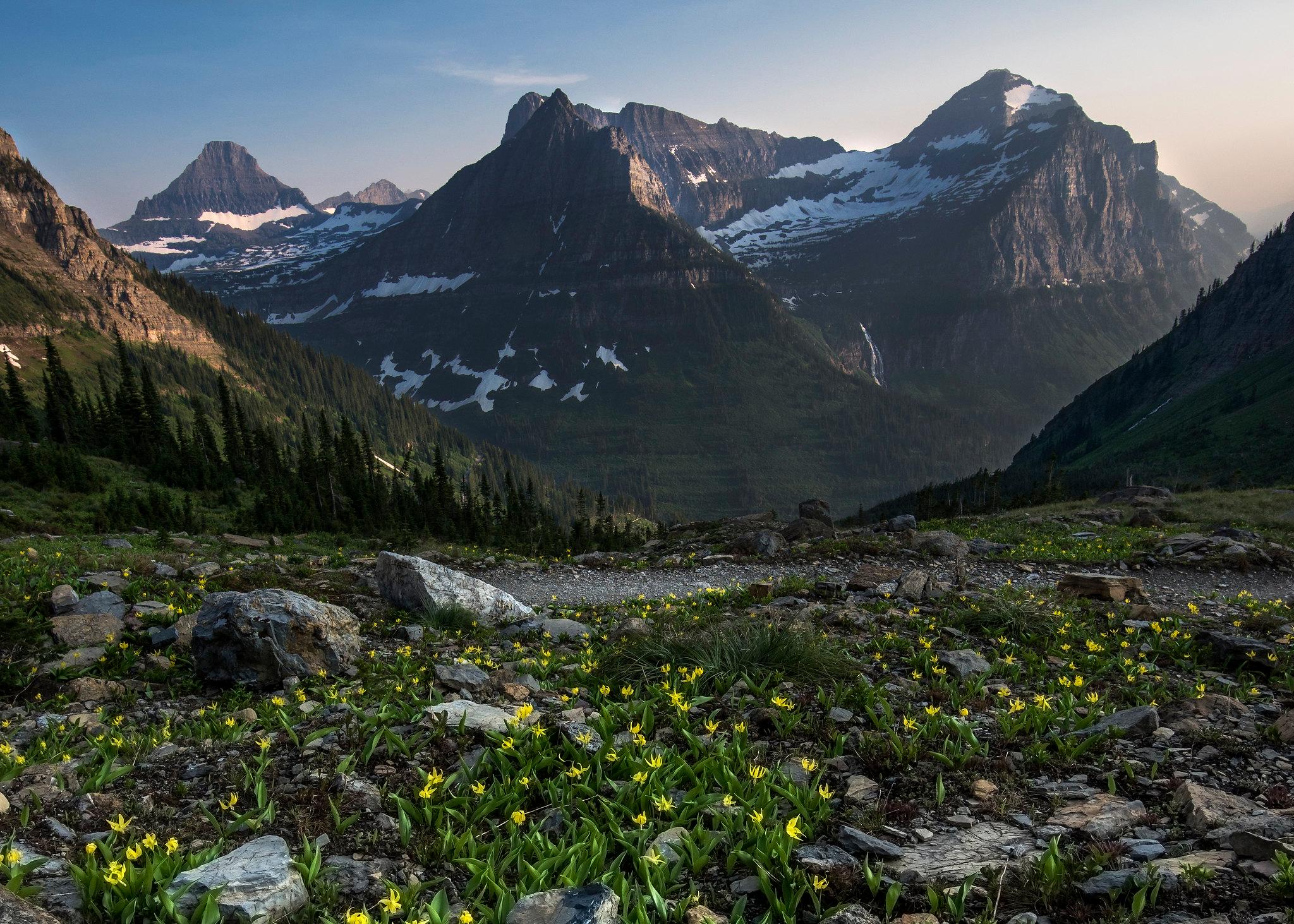
NPS via NPS.gov (Public Domain)
Glacier National Park: Going-to-the-Sun Road & Complete 2026 Guide
10 min read
Park Guide
Plan your Glacier National Park trip with this 2026 guide: $35 vehicle fee, Going-to-the-Sun Road access, and Logan Pass parking that fills by 7:30 AM.
Your plans
This article contains affiliate links — we may earn a small commission at no extra cost to you.
At a glance
Entrance Fee
Private vehicle $35 · Per person $20 · Motorcycle $30Full fee schedule
Hours
Glacier National Park is open 24 hours a day 365 days of the year. An entrance fee is required, even
Best Time
June-September (summer), September-October (fall colors)
Address
64 Grinnell Drive, West Glacier, MT, 59936
Website
48.6841, -113.8009
Google MapsIntroduction
On the trail to Avalanche Lake, the crunch of gravel underfoot gives way to the steady roar of the creek. The air carries the scent of damp cedar and cold stone. By mid-morning in July, the trailhead parking lot is a solid grid of vehicles—a reality that frames every visit to Glacier National Park. This landscape is defined by scale and scarcity: of time, of parking spots, and of the glaciers themselves. Over 700 miles of trails weave through terrain where geology takes center stage, a story told in exposed rock, carved valleys, and the slow retreat of ice. Your visit depends on one legendary road and a straightforward rule: arrive early to secure a parking spot. This guide covers the practicalities of navigating Going-to-the-Sun Road, understanding the park's distinct east-west divide, and planning a trip that accommodates the crowds. For detailed seasonal advice, consult our guide on the best time to visit.
The Practicalities: Fees, Access, and the Crowd Calendar

As of 2026, the entrance fee for a private vehicle is $35, valid for seven days. That fee applies per vehicle, not per person. If you're on foot or bike, it's $20 per person. There's also a $100 nonresident fee for any international visitor 16 or older, on top of the standard entrance cost, though an America the Beautiful Pass waives that extra charge. The park is technically open 24 hours a year, but that's a formality. What matters are the gates on Going-to-the-Sun Road and when they're plowed.
The park's operational heart beats from late June to early September. That's your window for full road access. Rangers will tell you the parking situation at Logan Pass, the alpine visitor center straddling the Continental Divide, is the single biggest logistical hurdle. The lot is designed for the 1960s and fills by 7:30 AM on a sunny summer day. Once it's full, rangers close the entrance, creating a line of idling cars that snakes down the mountain. Your best bet is to be parked by 7 AM, or plan to use the free shuttle system that runs along Going-to-the-Sun Road.
The east and west sides of the park feel like different countries. The west, near West Glacier and Apgar Village, gets the wet, dense air from the Pacific. Forests are thicker, valleys feel more enclosed. The east side, around St. Mary, is drier, windier, and opens up into the vast, grassy plains that roll toward the Divide. This clash of climates means you can have sunshine at Lake McDonald and a blizzard at Logan Pass an hour later. Always pack layers. Always.
Most visitors underestimate the distances. From the west entrance to Logan Pass is about 32 miles of winding mountain road - a 90-minute drive without traffic or construction delays. From St. Mary on the east side, it's 18 miles. Factor that in when you're chasing sunrise or sunset light. Cell service drops out at most trailheads and is nonexistent on the high passes. Download maps beforehand.
Going-to-the-Sun Road: More Than a Drive

Labeling Going-to-the-Sun Road a scenic drive is like calling a grizzly bear a large mammal—it doesn't capture the essence. This 50-mile engineering feat, completed in 1932, serves as the park's central artery and main draw. Driving it is essential, but doing so effectively demands a plan.
Start with the vehicle restrictions: anything exceeding 21 feet in length, 8 feet in width, or 10 feet in height is prohibited between Avalanche Creek and Sun Point. This rule covers most RVs and vehicles with extended side-view mirrors. Rangers enforce these limits strictly and will redirect non-compliant vehicles. The road is narrow, flanked by stone guardwalls and sheer drop-offs that command your full attention.
Key Stops and Strategy
Don't try to see everything in one pass. Pick a direction and a few key stops. Heading east from the west entrance, your first major pull-off is Lake McDonald. The water is clear enough to see stones 30 feet down, and the colorful pebbles along the shore are a photographer's staple in the calm morning light.
The trailhead for Avalanche Lake is next, and it's a zoo by 9 AM. The hike itself is a moderate 4.6-mile round trip through a tight gorge of dripping moss and red rock to a lake fed by cascading waterfalls. The common mistake is not continuing past the initial lake overlook; the trail continues along the shore to quieter views.
The road then begins its serious climb. The Loop is a sharp switchback offering the first real aerial view of the Heavens Peak area. A few miles further is the Weeping Wall, where water seeps from the cliff face onto the road - a cool spray on a hot day. Then you hit the big engineering features: the East Tunnel, a 408-foot bore through the rock, and immediately after, the Big Bend, a wide curve that serves as the main photo stop for views of the Garden Wall.
Logan Pass is the summit. The visitor center here is small and perpetually crowded. The real reason to come is the Highline Trail, which starts across the road. This is the park's iconic alpine route, traversing the Garden Wall with exposure that's not for the faint of heart. The first half-mile has a cable handhold drilled into the cliff. If that doesn't suit you, the paved, half-mile Hidden Lake Overlook trail from the visitor center delivers reliable mountain goat and bighorn sheep sightings on the boardwalk sections.
Descending eastward, you'll pass the Jackson Glacier Overlook - one of the few places you can see a named glacier from the road. It looks like a dirty snowfield clinging to the north face of Mount Jackson. Stop here to understand what "melting glaciers" actually means. Further down, Sun Point offers a vista of St. Mary Lake, and the road winds down to the drier, open landscapes of the east side.
The park service recommends driving early or late to avoid congestion. A good tactic is to enter from St. Mary at dawn, drive to Logan Pass for sunrise, and have the east-side trails to yourself while west-side visitors are still in line for coffee.
Hiking, Wildlife, and the Backcountry Ethos

With over 700 miles of trails, Glacier is a hiker's park. But not all miles are created equal. The choice often comes down to ambition versus accessibility.
Day Hikes Worth the Effort
For a manageable half-day, the Avalanche Lake Trail is the classic, but prepare for company. For something with similar payoff and fewer people, consider the Apikuni Falls Trail on the east side - short but steep, ending at a powerful waterfall. The full-day hike that appears on every list is the Highline Trail from Logan Pass. Most people hike out to the Granite Park Chalet, about 7.6 miles one-way, and arrange a shuttle or hike back. The chalet itself is a historic backcountry lodge, one of two in the park, and represents a bygone era of backcountry travel. You can learn more about these historic structures in our guide to lodging and accommodations.
For a deeper exploration of routes and difficulty levels, our dedicated page on hiking trails is essential reading.
The Wildlife Constant
Glacier isn't a zoo. Seeing wildlife is a function of patience, timing, and knowing where to look. Mountain goats are often seen on the cliffs above Logan Pass or along the Highline Trail - look for their shaggy white coats against the gray rock. Bighorn sheep frequent the same alpine meadows. Elk are more common in the lower valleys, especially at dawn and dusk near Many Glacier.
Then there are the bears. Both grizzly and black bears call Glacier home. Rangers at the visitor center will emphasize carrying bear spray, knowing how to use it, and hiking in groups. The sound of human conversation is a powerful deterrent. Never store food or scented items in your tent; use the food storage lockers provided at campgrounds and trailheads. For detailed safety tips and prime viewing areas, consult our wildlife viewing resource.
The park's bird life is prolific but often overlooked. Listen for the mechanical chatter of Clark's nutcracker in the subalpine fir, or watch for the electric blue flash of a mountain bluebird in open meadows. Harlequin ducks, small and strikingly patterned, can be spotted in the fast-moving streams of McDonald Creek in spring.
Where to Stay: Campgrounds and Nearby Towns

Your choice of bed dictates your daily routine. Inside the park, you have two main options: campgrounds or historic lodges.
Camping In-Park
The park maintains 13 frontcountry campgrounds. As of 2026, the largest is Apgar with 194 sites, followed by Fish Creek with 178. These two, along with St. Mary, Many Glacier, and a few others, accept reservations through Recreation.gov - book these months in advance. The rest, like Avalanche, Bowman Lake, and Kintla Lake, are first-come, first-served. Bowman and Kintla, in the remote North Fork region, offer profound solitude but require a long drive on rough gravel roads.
Sprague Creek Campground, with only 25 sites right on Lake McDonald, is the most coveted for its location. It's tents-only, no RVs. Cut Bank Campground on the east side is primitive, small (14 sites), and quiet. The common thread for all campgrounds is that they are typically full by noon from July through August. Our complete breakdown of camping options covers amenities, reservation strategies, and the best picks for solitude.
Gateway Communities
Outside the park, West Glacier and St. Mary are the primary service hubs. West Glacier has a few lodges, restaurants, and outfitters. St. Mary is smaller but has essential services. For more variety, the town of Whitefish, about 30 minutes from the west entrance, offers a full range of hotels, restaurants, and shops. Kalispell, where the nearest major airport (Glacier Park International) is located, is about 45 minutes away. On the east side, the Blackfeet Reservation town of Browning has limited services, and the larger community of East Glacier Park Village, about 30 minutes south, offers historic lodges like the Glacier Park Lodge.
Beyond the Sun Road: Other Park Areas

Going-to-the-Sun Road gets the glory, but other sections of Glacier National Park offer entirely different experiences with a fraction of the crowds.
Many Glacier
This valley on the east side is often called the "Switzerland of North America." It's a hub for some of the park's best day hikes, like the trek to Grinnell Glacier or Iceberg Lake. The Many Glacier Hotel, a massive Swiss-style lodge built in 1915, presides over Swiftcurrent Lake. The road in is long, winding, and often has wildlife delays - expect to see cars stopped for bears or moose. Parking here is also fiercely competitive.
Two Medicine
South of East Glacier, this area feels like a step back in time. It's quieter, with a historic campground, a general store, and boat tours on Two Medicine Lake. The hike to Scenic Point is a steep grind that rewards you with a 360-degree view of the plains to the east and the park's interior to the west. It's a good alternative when the Sun Road corridor feels overwhelming.
The North Fork
This is for the self-sufficient. The roads to Bowman and Kintla Lakes are long, washboard gravel. Services are virtually nonexistent past the tiny outpost of Polebridge, home of the famous Polebridge Mercantile bakery. The payoff is profound silence, lakeside camping, and a sense of having the Rockies to yourself. Your car's suspension will have strong opinions about the trip.
Practical Takeaways

- Parking is the First Hike. For Logan Pass or popular trailheads like Avalanche or Many Glacier, plan to arrive by 7 AM. If the lot is full, use the free shuttle immediately. Do not circle.
- Reserve Everything Early. As of 2026, you need a vehicle reservation for Going-to-the-Sun Road (and sometimes the North Fork and Many Glacier areas) for entry between 6 AM and 3 PM from late May through September. These are obtained online months in advance. Campground reservations open six months prior.
- Pack for Four Seasons in One Day. The weather at Logan Pass can be 30 degrees colder with driving wind and rain, even on a sunny July morning at the lake. A waterproof jacket, insulating layer, hat, and gloves are non-negotiable.
- Bear Spray is Mandatory Gear. Not optional. Rent or buy it before you enter the park. Keep it accessible, not buried in your pack. Know how to deploy it quickly.
- Fuel and Food are Limited. Gas up in Columbia Falls, Kalispell, or Browning before entering. Food options inside the park are expensive and limited. Pack lunches, snacks, and plenty of water.
- Embrace the East Side. If the west entrance feels congested, enter from St. Mary. The landscapes are different, the light is spectacular in the morning, and you'll often find shorter lines and a different pace.
- Leave the Big Rig at Home. If your vehicle is over 21 feet long or 8 feet wide, you cannot drive the core section of Going-to-the-Sun Road. Plan to use the shuttle or book a tour or guided experience.
Final Thoughts

Glacier National Park operates on a paradox. It's a wilderness of immense scale that funnels visitors into a few narrow corridors. The challenge - and the reward - is finding the rhythm that works for you. That might mean surrendering to the dawn patrol for a quiet hour on a famous trail, or it might mean ditching the checklist for the gravel road to Bowman Lake, where the only sound is the wind in the larch trees.
The glaciers the park is named for are retreating. That's not a political statement; it's a measurable geological fact you can see from the Jackson Glacier Overlook. Visiting now is about witnessing a landscape in transition, where the evidence of ancient ice is written across every U-shaped valley. It's about understanding that the postcard scenes require a bit of strategy, a lot of water, and a willingness to let the mountains set the schedule. The gift shop sells water for $4 a bottle. Bring your own.
Recommended Gear
What experienced visitors bring to Glacier National Park: Going-to-the-Sun Road & Complete 2026 Guide
Links may earn us a commission at no extra cost to you. We only recommend gear we believe in.
Hiking Essentials
Hydration Pack (3L)
Hands-free water for long trail days
Trekking Poles (Pair)
Save your knees on steep descents
Hiking Boots (Ankle Support)
Sturdy footwear for rocky, uneven trails
Sun & Heat Protection
Wide-Brim Sun Hat
Full coverage UPF 50+ protection at altitude
Insulated Water Bottle (32oz)
Keeps water cold in desert heat all day
Winter Gear
Microspikes / Traction Devices
Essential for icy rim trails in winter months
Packable Down Jacket
Lightweight warmth that stuffs into a pocket
Sources
- Official source: NPS — Glacier National Park nps.gov/glac/index.htm
Explore More National Parks

Glacier Bay National Park: Tidewater Glaciers & Southeast Alaska - 2026 Guide
Discover tidewater glaciers meeting the sea in Southeast Alaska. Complete 2026 guide to Glacier Bay...

Yellowstone National Park: Geysers, Wildlife & Complete 2026 Visitor Guide
Complete guide to yellowstone national park on map. Everything you need to know, updated for 2026.

North Cascades National Park: America's Alps & Glacier Wilderness - 2026 Guide
Discover America's Alps — glacier wilderness and remote North Cascades. Complete 2026 guide to North...

Grand Teton National Park: Complete Guide (2026)
That abrupt, sky-scraping wall defines Grand Teton National Park. A straightforward hike to a beauti...
Photo Gallery
More to Explore

Park Guide
Acadia National Park: Carriage Roads, Cadillac Mountain & 2026 Guide
Discover carriage roads, Cadillac Mountain, and rugged Maine coast. Complete 2026 guide to Acadia National Park — trails, fees, lodging, permits, and what rangers recommend.

Hiking Guide
Grand Canyon Hiking Trails: Day Hikes, Water Sources & Rim to Rim
Compare Grand Canyon hiking trails: Bright Angel, South Kaibab, Hermit, Grandview, and rim to rim, with distances, elevation, water stops, and trailhead access for each.

Best Of
Best of Glacier Bay National Park
The best of Glacier Bay is reached by boat: ranger-led day tours up the bay to the tidewater glaciers. What's worth it, how to book, and when to go (2026).

Campsite Guide
White Sands Backcountry Camping: Closed for 2026 — What to Know
As of 2026, backcountry camping at White Sands National Park is closed for site rehabilitation. What that means, and where to camp nearby instead.

Weather Guide
Guadalupe Mountains National Park Weather: Weather
Guadalupe Mountains National Park: weather guide guide updated 2026. Practical visitor information, reservations, and seasonal tips worth bookmarking before

Best Of
Best of Cuyahoga Valley National Park: Best Things to Do
Seeing a Cleveland Orchestra concert with the woods as your backdrop is a uniquely Cuyahoga Valley experience.
Sign in to join the conversation.
Sources & Attribution
Location data courtesy of the National Park Service (U.S. Department of the Interior). NPS data is public domain. Official NPS page.
Images: NPS; NPS; NPS; NPS; NPS; NPS; NPS; NPS and others.
Map data © OpenStreetMap contributors.
Park operations alerts: NPS.gov · Weather and weather hazards: National Weather Service · Live conditions.
Information may change. Always verify fees, hours, and conditions directly with the official source before visiting.
Did this guide help? Share it with a friend.