Bear Lake Road is a 9.2-mile paved route climbing from 8,200 to 9,475 feet, placing you at the core of the park's densest trail system. Most east-side visitors prioritize this corridor because it provides direct access to alpine lakes, waterfalls, and high-country terrain. Parking logistics demand careful planning. Many visitors don't realize how quickly the main lots reach capacity between June and September. In my experience, arriving after 7:30 AM at Bear Lake or Glacier Gorge trailheads on a summer weekend guarantees reliance on the shuttle system.
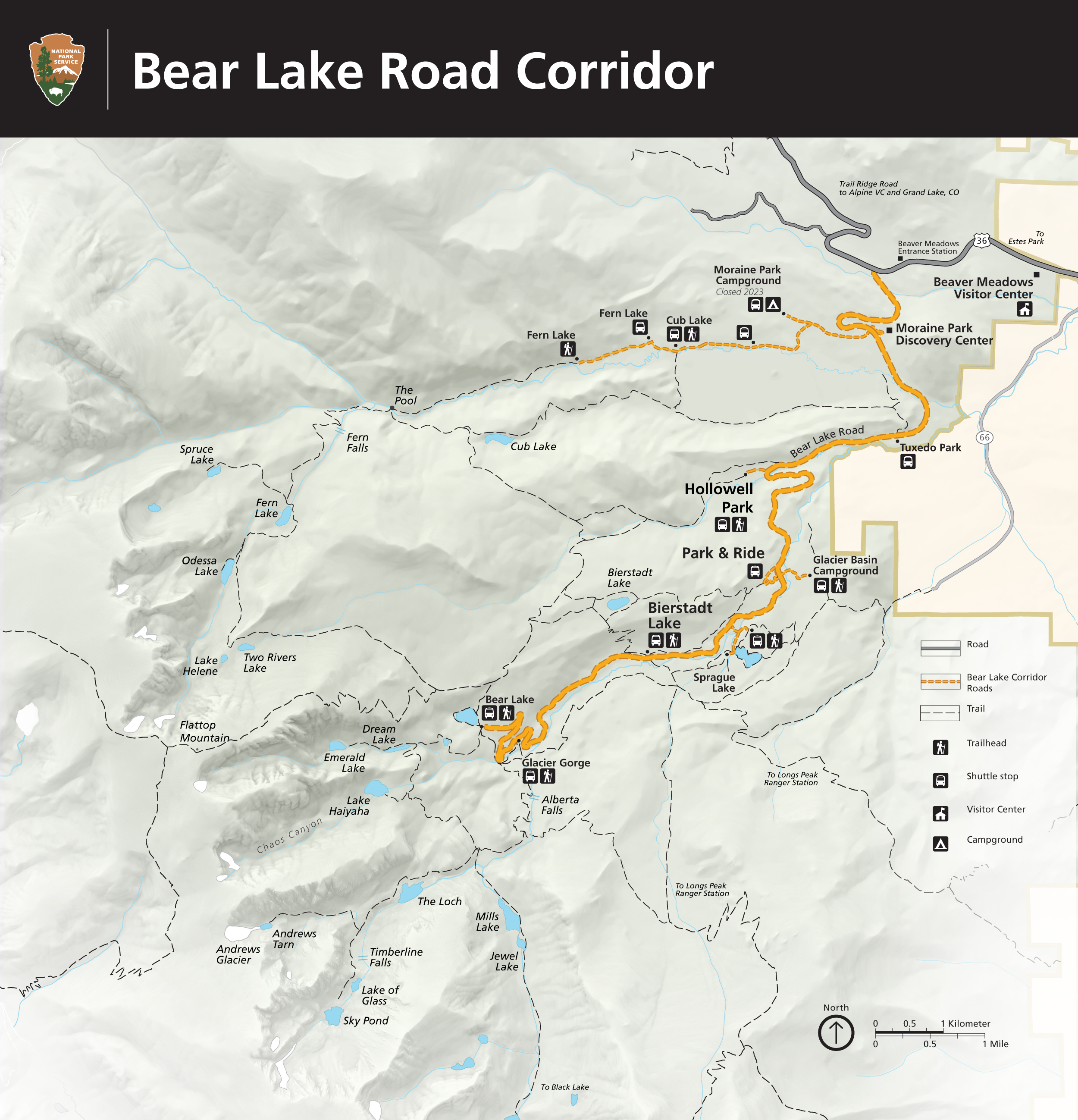
NPS via NPS.gov (Public Domain)
Exploring the Bear Lake Road Corridor: The Essential 2026 Visitor Guide
10 min read
Places & Points of Interest
Expect zero reliable service for the entire length of Bear Lake Road. From the entrance station, follow signs for Bear Lake Road; the turnoff is about a mile inside the park.
Your plans
Quick Information
- Entrance Fee: A park entrance pass is required. As of 2026, a 1-day vehicle pass is $35. An annual Rocky Mountain National Park pass is $70. The America the Beautiful Annual Pass ($80) is also accepted.
- Hours: The road is open year-round, but access is managed via the park's timed entry permit system from late May through mid-October. During this period, you need both an entrance pass and a timed entry permit to access the corridor between 5 AM and 6 PM.
- Best Time to Visit: Early morning, any day of the week. For seasons, late June through September offers the most trail access, but July and August bring afternoon thunderstorms and crowds. September is quieter with changing aspens.
- Location: Rocky Mountain National Park, Colorado. Nearest town: Estes Park. The road begins at the junction with Trail Ridge Road, just past the Beaver Meadows Entrance.
- Accessibility: The Sprague Lake Loop (0.7 miles) is a fully accessible, paved trail. The Bear Lake Trailhead has accessible parking and restrooms. The trail around Bear Lake is generally flat but has roots and rocks; it is not considered ADA-compliant.
- Cell Service: Cell service drops out at the Beaver Meadows Entrance. Expect zero reliable service for the entire length of Bear Lake Road. Download maps and information beforehand.
- Restrooms: Flush toilets are available at the Park & Ride shuttle lot and the Bear Lake Trailhead. Vault toilets are at the Bierstadt Lake and Glacier Gorge trailheads.
- Parking: The Bear Lake lot holds about 200 vehicles and fills by 7:30 AM in summer. The Glacier Gorge lot holds about 30 and fills even earlier. The Park & Ride shuttle lot is your backup plan and also fills by mid-morning on peak days.
Getting There
From Denver International Airport, take I-25 north to US-36 west. Follow US-36 through Boulder and Lyons to Estes Park. The drive is about 90 miles and takes roughly 1 hour and 45 minutes without traffic. Enter the park via the Beaver Meadows Entrance, which is the closest entrance to Estes Park. From the entrance station, follow signs for Bear Lake Road; the turnoff is about a mile inside the park. The drive up the corridor itself takes about 25 minutes without stops, longer if you're behind RVs or stopping at pullouts.
The parking strategy is non-negotiable. Your goal is to arrive at your chosen trailhead before the lots fill. If you miss that window, you must use the free park shuttle from the Park & Ride lot. The shuttle runs frequently in summer but expect lines. Do not park on the roadside; you will be ticketed. In winter, the road is plowed but can be icy; traction devices (chains or 4WD with snow tires) are sometimes required.

What to Expect
You'll notice the elevation change in your ears and breathing. The road ascends through lodgepole pine and aspen forests, with intermittent views of the Continental Divide. Air thins and temperatures drop noticeably during the climb. Trailheads at the top typically run 10-15 degrees Fahrenheit cooler than Estes Park.tes Park. The surface underfoot on most trails is a mix of packed dirt, tree roots, and granite slabs. In shaded areas, snow and ice can persist into July.
The soundscape shifts with elevation. At the lower trailheads, you'll hear the constant rush of Glacier Creek. Higher up, the wind through the pines and the occasional croak of a Clark's nutcracker dominate. The smell is pure mountain air: pine resin, damp earth, and, after a rain, the sharp scent of ozone. First-time visitors are often caught off guard by the sheer number of people at the Bear Lake trailhead - it can feel like a busy city park. The common mistake is to linger at the lake's edge with the crowd. The trail register is full of comments about how hiking just a half-mile farther thins the herd dramatically.
Top Attractions & Points of Interest
Bear Lake
This is the namesake and the hub. The lake itself is a scenic, subalpine body of water reflecting Hallett Peak and Flattop Mountain. The 0.7-mile loop trail around it is flat and popular, with benches placed at viewpoints. Most visitors snap a photo at the lakeshore and leave. The better strategy is to use Bear Lake as a launching point. From here, trails branch off to Dream, Emerald, and Haiyaha lakes. Early morning is your best bet for calm water for reflections and fewer people.
Alberta Falls
Accessible from either the Glacier Gorge or Bear Lake trailheads, this 1.6-mile round trip hike is a park classic for a reason. Glacier Creek thunders down a granite chute, creating a powerful cascade. The trail to the falls is a steady but manageable climb through forest. It's often crowded by 9 AM. The best light for photography hits the falls in mid-morning. The trail narrows here at the viewing area, so be prepared to wait your turn for a photo.
Dream Lake and Emerald Lake
Think of this as a progressive hike. From Bear Lake, it's 1.1 miles to Dream Lake, a, narrow lake framed by towering peaks. Another 0.7 miles beyond that is Emerald Lake, sitting in a dramatic glacial cirque beneath the cliffs of Hallett Peak. The total round trip is 3.6 miles with about 770 feet of elevation gain. The section between Dream and Emerald is the steepest and often holds snow the longest. You'll pass Nymph Lake along the way, which is covered in yellow lily pads in summer. This hike delivers the most alpine scenery for the effort in the corridor.
Sprague Lake
This is your accessible, easy option. The 0.7-mile loop is flat, paved, and offers excellent views of the Continental Divide. It's a favorite for families with strollers, wheelchairs, and anyone wanting a gentle stroll. It's also a superb spot for sunrise. The parking lot is smaller and fills quickly, but it's on the shuttle route. Fishing is allowed here with a Colorado license.
The Alluvial Fan
Located off the road to Endovalley (a short detour just before the Bear Lake Road junction), this is a powerful landscape of moving water and massive boulders. It was created by a dam breach in 1982. You can walk along paved paths to viewpoints of the cascading water. It's a quick stop that showcases the raw geologic force of the mountains. The roar of the water is constant.

Activities
Hiking
This is the main event. The corridor provides access to over a dozen major trails, ranging from the 0.7-mile Bear Lake loop to the 8.8-mile round-trip climb to Flattop Mountain. For a moderate, rewarding hike, the 5-mile round trip to Mills Lake past Alberta Falls is a standout. Your calves will have strong opinions about the switchbacks on the way back from any of the lake hikes. Pack extra water for these stretches; the altitude dehydrates you faster. For detailed trail breakdowns, see our guide to the park's hiking trails.
Wildlife Viewing
Elk are frequently seen in the meadows along the lower sections of Bear Lake Road, especially at dawn and dusk. Mule deer and ground squirrels are common. Moose are less frequent but possible in wetland areas. The most reliable wildlife viewing often requires venturing onto quieter trails. Always maintain a distance of at least 75 feet from large animals. For dedicated tips, our wildlife viewing guide has more.
Winter Sports
From late October through June, this area transforms into a snowshoeing and cross-country skiing paradise. The road is plowed to the Bear Lake lot, which becomes a winter trailhead. The hike to Dream Lake on snowshoes is a completely different, silent experience. Traction devices like microspikes are mandatory on packed snow and ice - regular boots won't cut it. Rangers lead free snowshoe walks on weekends; check at a visitor center.
Photography
The golden hour after sunrise is prime, with soft light on Hallett Peak from the Bear Lake shore. Alberta Falls is best lit mid-morning. For lake reflections, you need dead-calm air, which usually happens at sunrise. A polarizing filter is useful for cutting glare off the water.
Scenic Driving
While Bear Lake Road is the main artery, connecting with the park's other famous drives is part of the experience. At the bottom of Bear Lake Road, you can head west onto Trail Ridge Road (seasonal, typically open late May to October) for high-alpine vistas. The unpaved Old Fall River Road (one-way uphill) offers a slower, more historic alternative. Both are covered in our guide to tours and guided experiences.
Seasonal Guide
* May-June: The road is open, but trails at higher elevations are snow-covered and muddy. Snowshoes or spikes may still be needed. The timed entry system is in effect. Crowds begin to build.
* July-August: All trails are generally snow-free. Afternoon thunderstorms are a daily occurrence - be off high, exposed terrain by noon. This is peak visitation. Parking lots are full by 7 AM. Wildflowers peak in July.
* September-October: The best balance. Cooler temperatures, fewer crowds after Labor Day, and brilliant gold aspen groves, especially at lower elevations. The timed entry system ends in mid-October. Early snowstorms are possible.
* November-April: A quiet, snowy wonderland. The road is plowed. Snowshoes or skis are needed for any trail travel. The Bear Lake lot is often only partially plowed. No timed entry permits are required. For a full breakdown of conditions, see our best time to visit analysis.

Practical Information
You need two things to enter between 5 AM and 6 PM from late May to mid-October: a park entrance pass (purchasable at the entrance station) and a Timed Entry Permit. These permits are released online in two batches: some months in advance, and some at 5 PM MT the day before entry. They sell out within minutes for summer dates. Plan this part first.
For camping options, the closest campground is Moraine Park (244 sites, $35/night as of 2026), which is open for winter camping on a first-come, first-served basis. Glacier Basin Campground is closer but was closed for the 2025/2026 winter season. Reservations for summer open months in advance on Recreation.gov.
For lodging and accommodations, Estes Park is your basecamp, offering everything from hotels to cabins. There are no hotels or restaurants inside the park on this side. The last gas stations and full grocery stores are in Estes Park.
Safety & Preparation
Altitude: You are starting hikes between 9,000 and 9,500 feet. Drink twice as much water as you think you need. Headache and nausea are signs of altitude sickness - the only cure is to descend.
Weather: Mountain weather changes instantly. Carry rain gear and warm layers year-round. Afternoon lightning is a severe, life-threatening hazard in summer. If you hear thunder, you are already in danger.
Wildlife: Do not approach elk, especially during the fall rut (September-October) when bulls are aggressive. Store all food and trash properly to avoid attracting bears and smaller animals.
Trail Conditions: Snow and ice persist on north-facing slopes into summer. Call the park's recorded trail conditions line or stop at a visitor center for the latest report. Turning around due to conditions is not failure; it's smart.
Emergency: Cell service is nonexistent. Know your route. In an emergency, contact a ranger at a trailhead or send someone for help. The main visitor center for this area is Beaver Meadows.

Insider Tips
- The Shuttle Secret: If the Bear Lake shuttle line is long, take the shuttle to Bierstadt Lake instead. From the Bierstadt trailhead, it's a 1.7-mile hike (mostly flat) through beautiful forest to the Bear Lake area, bypassing the crowds.
- Parking End-Run: The Park & Ride lot often has spaces later in the morning after the initial rush. Park there, take the shuttle up, and hike. When you return, the shuttle line to go down is usually much shorter than the line to go up.
- Afternoon Advantage: Most day-trippers start early and are heading out by 2 PM. If you have a later timed entry permit, you can often find parking at Bear Lake after 3 PM as people leave.
- Skip the First View: At Bear Lake, everyone clusters at the first viewing area by the trailhead. Walk 200 yards clockwise around the lake for the same view of Hallett Peak without the people in your photo.
- Water Refill: The only water refill station at the top is at the Bear Lake Trailhead restrooms. Fill all bottles there before starting your hike.
- Bierstadt Lake is Underrated: The hike to Bierstadt Lake is 2 miles one-way with 290 feet of gain from Bear Lake. It sits atop a moraine and feels more remote than the other, more famous lakes. You'll often have it to yourself.
- What the Website Doesn't Mention: The vault toilets at the Glacier Gorge trailhead are almost always cleaner and have shorter lines than the flush toilets at Bear Lake.
For more information, see our complete Exploring the Bear Lake Road Corridor: exploring the bear lake road corridor Guide.
Sources
- Official source: NPS — Rocky Mountain National Park nps.gov/romo/index.htm
Photo Gallery
More to Explore

Park Guide
Acadia National Park: Carriage Roads, Cadillac Mountain & 2026 Guide
Discover carriage roads, Cadillac Mountain, and rugged Maine coast. Complete 2026 guide to Acadia National Park — trails, fees, lodging, permits, and what rangers recommend.

Hiking Guide
Grand Canyon Hiking Trails: Day Hikes, Water Sources & Rim to Rim
Compare Grand Canyon hiking trails: Bright Angel, South Kaibab, Hermit, Grandview, and rim to rim, with distances, elevation, water stops, and trailhead access for each.

Best Of
Best of Glacier Bay National Park
The best of Glacier Bay is reached by boat: ranger-led day tours up the bay to the tidewater glaciers. What's worth it, how to book, and when to go (2026).

Campsite Guide
White Sands Backcountry Camping: Closed for 2026 — What to Know
As of 2026, backcountry camping at White Sands National Park is closed for site rehabilitation. What that means, and where to camp nearby instead.

Weather Guide
Guadalupe Mountains National Park Weather: Weather
Guadalupe Mountains National Park: weather guide guide updated 2026. Practical visitor information, reservations, and seasonal tips worth bookmarking before

Best Of
Best of Cuyahoga Valley National Park: Best Things to Do
Seeing a Cleveland Orchestra concert with the woods as your backdrop is a uniquely Cuyahoga Valley experience.
Sign in to join the conversation.
Sources & Attribution
Location data courtesy of the National Park Service (U.S. Department of the Interior). NPS data is public domain.
Images: NPS; NPS; NPS; NPS; NPS.
Park operations alerts: NPS.gov · Weather and weather hazards: National Weather Service · Live conditions.
Information may change. Always verify fees, hours, and conditions directly with the official source before visiting.
Did this guide help? Share it with a friend.