Forget temperature—Rocky Mountain weather is about altitude. The fundamental truth here is that you'll pass through three distinct climate zones in a single afternoon. The forecast for Estes Park becomes irrelevant once you gain 3,000 feet.
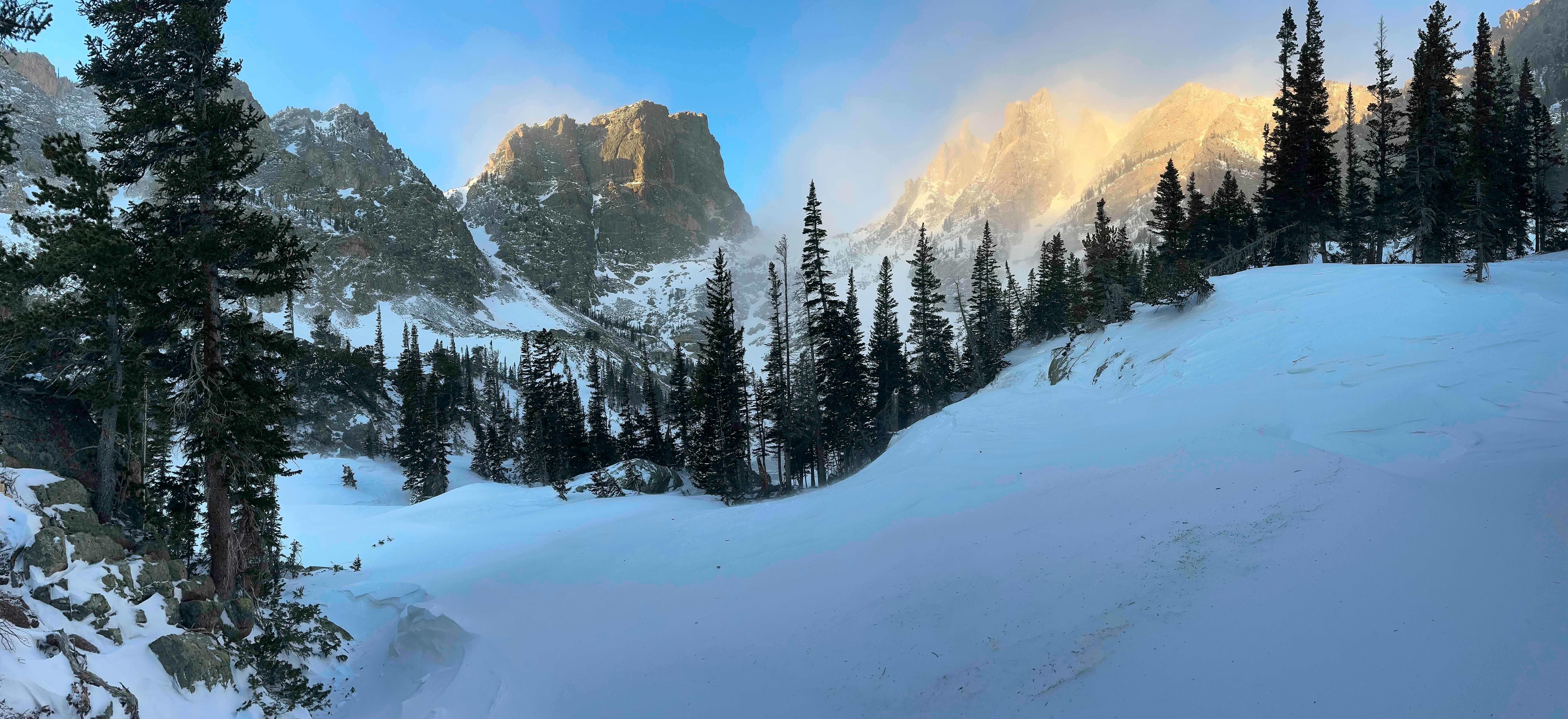
NPS via NPS.gov (Public Domain)
Rocky Mountain National Park Weather
8 min read
Weather Guide
Rocky Mountain weather swings 30°F in an hour. Learn the park's three climate zones and why you must be below treeline by noon in summer.
The park's vertical rise - from 7,800 feet at the Beaver Meadows entrance to over 14,000 feet at the summit of Longs Peak - creates its own weather. A sunny, 75-degree morning at Bear Lake can turn into a 45-degree, sideways-hail storm on the tundra above treeline in under an hour. Most first-time visitors are caught off guard not by cold, but by the speed and violence of the change. Rangers will tell you that hypothermia is a summer risk here. They're not exaggerating.
The Weather Reality
Forget checking one forecast. You need three: one for the valley (Estes Park, around 7,500 feet), one for the high valleys (like Bear Lake at 9,475 feet), and one for the alpine zone above 11,000 feet. The National Weather Service page for the park is your only reliable source; valley apps are useless.
The park sits in a complex zone where continental air masses collide. The result is the infamous afternoon thunderstorm, a near-daily ritual from late June through August. These aren't gentle rains. They are lightning factories with gusty winds and sudden, plunging temperatures. The rule is simple: be below treeline by noon. Hikers who ignore this fill the trail registers with stories of close calls.
What the official forecasts miss is the wind. Above treeline, 30-50 mph winds are a standard summer afternoon. In winter, gusts can exceed 100 mph. This wind chill factor is what makes conditions brutal, not just the air temperature. The other hidden factor is UV intensity. At 12,000 feet, UV radiation is nearly 40% stronger than at sea level. You'll burn in 20 minutes without protection, even on a cool, cloudy day.

Month by Month
The park's weather follows a compressed timeline. Spring and fall are fleeting transitions; winter and summer dominate the seasonal rhythm.
May & June
This is the shoulder season of dramatic transition. Trail Ridge Road, the main alpine corridor, is usually closed until late May or early June as crews plow through 20-foot snowdrifts.
Temperatures range from highs in the 50s to lows well below freezing at night. Snowstorms are common, especially in May. Lower elevation trails like those around Moraine Park are often clear and muddy, while anything above 10,000 feet remains snow-covered and requires traction devices (microspikes) at minimum.
Wildlife is highly active. Elk are calving in the meadows, and bears are emerging. Crowds are moderate until schools let out in mid-June. The challenge is unpredictable access; the park you plan to visit on Monday might be half-closed by a Tuesday snowstorm. The reward is having iconic trails nearly to yourself, with snow-capped peaks as a backdrop.
July & August
This is peak summer visitation and the only reliable window for high-altitude hiking without significant snow travel. It's also peak thunderstorm season.
Daytime highs in the valleys can reach the 70s and even low 80s. At Bear Lake, expect 60s. On the tundra, a sunny day might hit 50. Nights dip into the 40s, even 30s. Afternoon thunderstorms roll in like clockwork between 1 and 3 PM. Everything is open, including Trail Ridge Road and the Alpine Visitor Center.
Crowds are at their maximum. Parking lots at popular trailheads like Bear Lake fill by 7 AM. The trade-off is access: all 300+ miles of trails are generally clear of snow. Wildflowers peak in mid-to-late July, especially in the subalpine meadows. Mosquitoes can be fierce in wet areas early in the season.
September & October
Many consider this the best time to visit. The monsoon pattern breaks, leading to more stable, sunny days. Afternoon storms become less frequent.
September days are crisp, with highs in the 60s at lower elevations and 50s up high. Nights begin to freeze regularly. By October, daytime highs might only reach the 50s, with overnight lows in the 20s. The first significant snows can dust the high country anytime after mid-September.
This is the elk rut. The bugling of bull elk in Moraine and Horseshoe Parks is a defining sound of the season. Crowds diminish significantly after Labor Day, though weekends during peak fall color (usually late September) can be busy. Trail Ridge Road often closes for the season by mid-October, depending on snow. Aspen groves at lower elevations turn a brilliant gold.
November through April
This is winter. The park is open, but it's a different world. Trail Ridge Road is closed. Access is limited to the lower elevations on either side of the Continental Divide.
Temperatures are cold. January highs in Estes Park might reach the 30s, with lows near zero. In the park, it's 10-20 degrees colder. Wind is the dominant factor, creating extreme wind chills. Snowpack is deep and persistent above 9,000 feet.
This is the season for snowshoeing, cross-country skiing, and winter wildlife watching. Crowds are minimal. Facilities are limited; some restrooms are closed, and water systems are shut off. The challenge is preparation: you need knowledge of avalanche terrain (yes, it exists here) and full winter survival gear. The reward is profound silence and landscapes of snow and ice.

Best Times for Specific Activities
High Country Hiking
The window is short: mid-July to mid-September. Before that, you're dealing with steep snowfields and route-finding issues on passes. After that, early season snowstorms become likely. For Longs Peak, the standard Keyhole Route is typically in condition from early August to late September.
Wildlife Viewing
Elk are visible year-round, but for the dramatic rut with bugling and sparring, target mid-September to mid-October at dawn and dusk in the meadow complexes. Bighorn sheep are often seen at Sheep Lakes in Horseshoe Park from May through August. Moose are best spotted on the wetter west side of the park, particularly in summer and early fall.
Wildflowers
Peak bloom follows the melting snow. Lower elevations (like Cub Lake) peak in late June. Subalpine zones (like around Bear Lake) hit their stride in mid-to-late July. The tundra has its own brief, brilliant display in late July and early August.
Fall Colors
The show starts high and moves down. Tundra vegetation turns red in early September. The classic golden aspen displays in lower valleys like Moraine Park and on the west side peak from late September to early October. It's a narrow window, often lasting only 7-10 days at a specific location.
Stargazing & Winter Sports
Clear, dry air makes for excellent stargazing year-round, but fall and winter offer the longest nights. For snowshoeing and cross-country skiing, the season runs December through March, with the most reliable snowpack at higher elevations in January and February.

What to Pack by Season
The constant across all seasons is layers. Cotton kills here; wear synthetic or wool.
Summer (June-August): Start with a moisture-wicking base layer. Always have a insulating mid-layer (fleece or puffy) and a waterproof, windproof shell in your pack - even for a short hike. Wide-brimmed hat, sunglasses, and SPF 30+ sunscreen are non-negotiable. Sturdy hiking boots with good traction are essential. Pack extra water; the dry air dehydrates you quickly.
Fall (September-October): All of the above, but swap the light puffy for a heavier one. Add a warm hat and gloves, especially for morning starts. Traction devices like microspikes become advisable for any hike above 10,000 feet after mid-September.
Winter (November-April): This is expedition-level packing. Heavy insulated parka, insulated waterproof pants, mountaineering gloves, balaclava, and goggles for wind. Insulated, waterproof boots. Snowshoes or skis are required for most trails. Carry avalanche safety gear (beacon, probe, shovel) and know how to use it if venturing into steep terrain. A thermos with a hot drink is a safety item.
Spring (May): Expect everything. Pack for winter conditions at altitude and summer in the valley. Waterproof boots for mud, gaiters for slushy snow, and all your summer sun protection.

What the Forecast Doesn't Tell You
- The Temperature Inversion: On clear, calm winter mornings, it's often colder in the park's low valleys than up on the alpine ridges. That -10°F reading at Beaver Meadows? It might be a "balmy" 15°F at the Rock Cut turnout. Cold air sinks and pools.
- Microclimate Whiplash: The east side (Estes Park) is often drier and sunnier than the west side (Grand Lake). A storm system can dump snow on one side while the other sees broken clouds. Check forecasts for both.
- Lightning Reach: During a thunderstorm, lightning can strike from a cloud 10 miles away. If you hear thunder, you are already in danger. The "see lightning, flee" advice is too late.
- Hydration Altitude Tax: At 10,000 feet, you lose water through respiration about twice as fast as at sea level. You need to drink roughly twice as much water to avoid altitude-related headaches and fatigue, which many mistake for simple tiredness.
- The Post-Storm Ice: A sunny afternoon rain shower at 11,000 feet can freeze on contact with the trail rocks as soon as the sun dips behind a peak. That easy hike up becomes a treacherous ice rink on the way down.
- Wind Direction is Everything: A west wind generally brings drier, more stable weather. An east wind (upslope) pushes moisture from the plains up the mountains, creating clouds, fog, and precipitation on the east side of the Divide.
- Road Black Ice: On Trail Ridge Road, shaded curves can harbor black ice even on sunny summer mornings. Drive like it's there, because it often is.
Practical Takeaways
- Altitude is the boss. Plan every activity, clothing layer, and water carry around the elevation gain of your hike, not the parking lot weather.
- Be a morning person. Start hikes at or before sunrise. You'll get parking, avoid crowds, and be heading down as the thunderstorms build. This is the single most effective strategy for a good summer visit.
- Pack the shell. No matter how blue the sky looks when you leave the trailhead, your waterproof/windproof jacket is the most important piece of safety gear in your pack from May through October.
- Know your escape routes. Before you head above treeline, identify on your map where the nearest safe, low-elevation terrain is. When a storm builds, you won't have time to figure it out.
- Winter is a commitment. Don't venture into the park's winter backcountry without specific, current knowledge of snow conditions and avalanche risk. This isn't a place for casual snow play.
- Check the right source. Use the National Weather Service forecast for Rocky Mountain National Park, not Estes Park. It's the only one that accounts for alpine conditions.
- Your car is a weather station. If the wind is rocking your vehicle at the Alpine Visitor Center, it's twice as strong on the exposed tundra trail 50 yards away. Let common sense override your itinerary.
Understanding Rocky Mountain National Park weather isn't about avoiding bad days - it's about respecting the mountain environment on every single day. Plan for the range, pack for the worst, and you'll be rewarded with some of the most dramatic landscapes in the country. For more on navigating the park beyond the climate, see our complete visitor guide and specific advice on the best hiking trails.
Related: rocky mountain national park guide
Sources
- Official source: NPS — Rocky Mountain National Park nps.gov/romo/index.htm
Photo Gallery
More to Explore

Park Guide
Acadia National Park: Carriage Roads, Cadillac Mountain & 2026 Guide
Discover carriage roads, Cadillac Mountain, and rugged Maine coast. Complete 2026 guide to Acadia National Park — trails, fees, lodging, permits, and what rangers recommend.

Hiking Guide
Grand Canyon Hiking Trails: Day Hikes, Water Sources & Rim to Rim
Compare Grand Canyon hiking trails: Bright Angel, South Kaibab, Hermit, Grandview, and rim to rim, with distances, elevation, water stops, and trailhead access for each.

Best Of
Best of Glacier Bay National Park
The best of Glacier Bay is reached by boat: ranger-led day tours up the bay to the tidewater glaciers. What's worth it, how to book, and when to go (2026).

Campsite Guide
White Sands Backcountry Camping: Closed for 2026 — What to Know
As of 2026, backcountry camping at White Sands National Park is closed for site rehabilitation. What that means, and where to camp nearby instead.

Weather Guide
Guadalupe Mountains National Park Weather: Weather
Guadalupe Mountains National Park: weather guide guide updated 2026. Practical visitor information, reservations, and seasonal tips worth bookmarking before

Best Of
Best of Cuyahoga Valley National Park: Best Things to Do
Seeing a Cleveland Orchestra concert with the woods as your backdrop is a uniquely Cuyahoga Valley experience.
Sign in to join the conversation.
Sources & Attribution
Location data courtesy of the National Park Service (U.S. Department of the Interior). NPS data is public domain. Official NPS page.
Images: NPS; NPS; NPS; NPS; NPS.
Map data © OpenStreetMap contributors.
Park operations alerts: NPS.gov · Weather and weather hazards: National Weather Service · Live conditions.
Information may change. Always verify fees, hours, and conditions directly with the official source before visiting.
Did this guide help? Share it with a friend.