Rocky Mountain National Park Hiking: Best Hikes Bear Lake (2026 Guide)
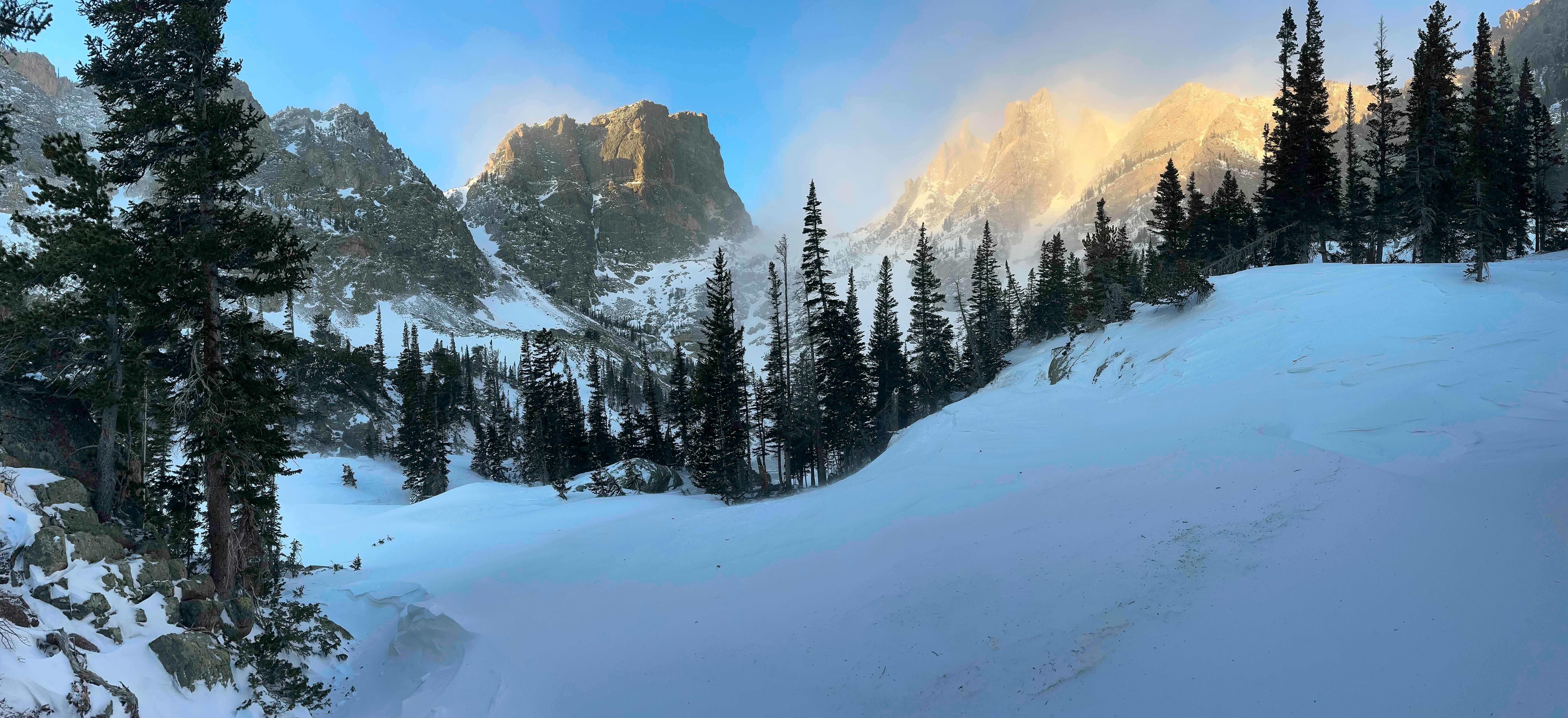
NPS via NPS.gov (Public Domain)
Best Hikes Bear Lake, Rocky Mountain National Park (2026)
9 min read
Hiking Guide
Discover best hikes bear lake rocky mountain national park with our comprehensive guide. Expert tips, practical information, and insider knowledge.
This article contains affiliate links — we may earn a small commission at no extra cost to you.
What Hiking Here Actually Means
Altitude dictates everything here. The Bear Lake corridor begins at 9,475 feet—higher than the summits of many other parks. Your first mile will feel like your fifth at sea level. Most newcomers are unprepared for how quickly a modest incline leaves them winded. The terrain isn't technical, but the elevation gain is relentless, and weather can shift from sun to sleet faster than you can finish a snack. Seasoned visitors plan their days around July and August afternoon thunderstorms and know better than to trust any forecast that ignores the park's 7,000-foot vertical range.
The Classic Bear Lake Loop: The Easiest Start
This isn't a hike so much as a mandatory acclimatization walk. Do it first.
Distance: 0.7 miles
Elevation Gain: 20 feet
Trailhead & Parking: Bear Lake Trailhead. This is the epicenter. The lot is often full by 7:30 AM on a summer weekday. Rangers will tell you to use the park-and-ride shuttle from the Glacier Basin or Estes Park Visitor Center lots. They're right. The shuttle is your best bet from late May through September.
The Trail: A wide, packed gravel and boardwalk loop circling the lake. It's almost entirely flat. Benches are placed at intervals, most facing the water with a direct view of Hallett Peak and Flattop Mountain. The surface can be icy into June and again after September snows.
The Moment: The first clear view of Hallett Peak's sheer north face reflected in the still morning water. It happens about a quarter-mile in from the trailhead, on the lake's west side.
What Most Underestimate: How crowded the 10 feet of shoreline at each "photo spot" gets by 10 AM. Early morning is your best bet for quiet. It's also where you'll gauge your personal reaction to 9,500 feet.
Best Time: Sunrise, or as early as you can get a shuttle. The light on the peaks is sharp and the crowds are minimal.

Emerald Lake via Dream & Nymph: The Crowd-Pleaser
This is the most popular destination hike for a reason. It strings together three distinct alpine lakes in under four miles.
Distance: 3.6 miles round trip
Elevation Gain: 771 feet
Trailhead & Parking: Bear Lake Trailhead. Same parking reality as the loop. If you're driving, aim to be in the lot by 6:45 AM. No exceptions.
The Trail: The trail narrows here, past the Bear Lake loop junction. You'll climb steadily on rocky, rooted path through spruce-fir forest to Nymph Lake (0.5 miles), which is covered in yellow lily pads in summer. Another climb brings you to the shoreline of Dream Lake, a long, narrow lake with those iconic views of Hallett Peak. The final push to Emerald Lake is the steepest section, over talus and boulders. The trail is well-defined but can be a slick, packed snow chute well into June.
The Moment: Cresting the final rise to see Emerald Lake cradled in a sheer rock cirque, with Tyndall Glacier clinging to the cliffs above. The color shifts from deep green to turquoise depending on the sun and glacial silt.
What Most Underestimate: The altitude gain is cumulative and feels steeper on the return. Also, the rock-hopping final section to Emerald Lake's shore is often wet and slippery.
Best Time: Start by 7 AM to have the lakes to yourself on the way up. You'll pass the crowds on your way down. Late September offers golden aspens and fewer people, but an earlier chance of snow.
Lake Haiyaha: The Less-Traveled Option
Lake Haiyaha offers a quieter, more rugged experience.
Distance: 4.2 miles round trip
Elevation Gain: 745 feet
Trailhead & Parking: Bear Lake Trailhead. Expect the same parking challenges.
The Trail: You'll follow thee Emerald Lake trail for the first 0.8 miles to the Dream Lake junction. Here, instead of going right to Dream Lake, go left (north) on the Haiyaha trail. The climb is steady through forest, with fewer people. The final approach involves a fun, hands-on scramble over a jumble of giant boulders to reach the lake shore.
The Trail: The surface changes from packed dirt to exposed granite slabs about a mile in. Watch your footing on the transition.
The Moment: The first glimpse of Lake Haiyaha's milky, opaque turquoise water, colored by glacial flour, through a window in the giant boulders.
What Most Underestimate: The boulder field at the end. It's not dangerous, but it requires stable footing and isn't a simple walk-up. The lake is also significantly colder and more windswept than the others.
Best Time: Mid-morning. Since it's less popular, you can start a bit later and still find solitude. The boulder field is treacherous when wet or icy.

Mills Lake: The Glacier Gorge Alternative
Starting from the Glacier Gorge Trailhead, this route trades some of the Bear Lake crowds for a longer approach past a major waterfall.
Distance: 5 miles round trip
Elevation Gain: 700 feet
Trailhead & Parking: Glacier Gorge Trailhead. This smaller lot fills even earlier than Bear Lake, often by 7 AM. The shuttle stop is a 0.6-mile walk from the actual trailhead if you're dropped off.
The Trail: A moderate climb through pine forest brings you to Alberta Falls at 0.8 miles - a good spot to pause. Continue upward, with the trail offering glimpses of Glacier Gorge. The final section to Mills Lake is a series of steps and switchbacks. The lake sits directly under the sheer cliffs of Thatchtop and Powell Peaks.
The Moment: The trail emerges from the trees onto the rocky shoreline of Mills Lake, with its long, narrow form stretching toward the base of the mountains.
What Most Underestimate: The distance and gain feel more substantial than the Emerald Lake hike, partly due to the starting elevation (9,240 feet). It's a quieter, more sustained hike.
Best Time: Early morning to secure parking at the trailhead, or use the shuttle. Afternoon light on the cliffs surrounding the lake is particularly good for photography.
Flattop Mountain: The Continental Divide Grind
This is the route for hikers who want to stand on the Continental Divide and earn it directly from Bear Lake.
Distance: 8.8 miles round trip
Elevation Gain: 2,849 feet
Trailhead & Parking: Bear Lake Trailhead. A pre-dawn start is non-negotiable to finish before afternoon storms.
The Trail: The first mile is shared with the Emerald Lake trail. At the Dream Lake junction, you continue straight up, up, and up. The forest thins into krummholz (dwarfed, wind-sculpted trees), then gives way to open tundra. The final push is a steep, rocky scramble to the broad, flat summit at 12,324 feet.
The Moment: Turning around on the tundra section to see Bear Lake, Emerald Lake, and the entire Tyndall Gorge laid out like a map thousands of feet below you.
What Most Underestimate: The exposure and weather volatility above treeline. The wind is almost always blowing, and summer storms build with alarming speed. This is not a hike to attempt without layers, rain gear, and a firm turnaround time.
Best Time: July through mid-September, on a clear day with a forecast of less than 20% chance of afternoon storms. Start no later than 6 AM.

Bierstadt Lake: The Moraine Viewpoint
A quieter lake hike that starts high and descends to the lake, offering a unique perspective.
Distance: 2 miles one-way (from Bear Lake Trailhead)
Elevation Gain: 290 feet (it's a net descent to the lake, but you have to climb back out)
Trailhead & Parking: Can start from Bear Lake or Bierstadt Lake Trailhead. The Bear Lake start is more common and avoids a steep climb.
The Trail: From Bear Lake, the trail climbs switchbacks through forest for about a mile to a high point on a moraine ridge, then descends to the lake. The lake itself is forested and feels more secluded.
The Moment: Reaching the moraine ridge and getting a sudden, sweeping view over Moraine Park to the south - a vista completely different from the tight valleys of other hikes.
What Most Underestimate: The climb back up to the moraine ridge from the lake on the return trip. It's short but sharp, and at altitude it gets your attention.
Best Time: Late afternoon. The light over Moraine Park is warm, and the lake is often deserted.
Seasonal Trail Conditions
June: Expect significant snowpack above 10,500 feet. Trails to Emerald Lake, Haiyaha, and Flattop will have long sections of hard-packed, icy snow. Microspikes or traction devices are mandatory, not optional. The Bear Lake shuttle typically begins daily operations.
July: Snow melts rapidly at lower elevations. Wildflowers explode in subalpine meadows in early July. Afternoon thunderstorms are a daily occurrence starting around 1 PM. Be off high peaks and exposed tundra by noon.
August: Prime hiking conditions below treeline. Mosquitoes can be fierce near lakes and marshes in the first two weeks. Tundra hikes are dry and accessible. Crowds peak.
September: The best month for experienced hikers. Crowds diminish after Labor Day. Days are cooler, nights are cold. First snows can dust the high country anytime after mid-September. Aspens in lower valleys turn gold late in the month.
October-May: Winter. Most trails are snow-covered. Hiking transforms to snowshoeing or travel with traction devices. The road to Bear Lake is plowed, but trailhead parking is limited. Always check avalanche conditions before traveling in steep terrain.

Trailhead Logistics
The parking situation here is the single biggest logistical hurdle. The Bear Lake and Glacier Gorge lots are often full by 7:30 AM. Rangers will tell you the shuttle is the most reliable way to access these trails from late May through September. The free shuttle runs from the Park & Ride lot at Glacier Basin. Cell service drops out at the park entrance and is non-existent at the trailheads.
You must have a timed entry permit to enter the Bear Lake Road Corridor from 5 AM to 6 PM between late May and mid-October. This is in addition to your park entrance fee. Reserve these online at Recreation.gov well in advance. No permit is needed if you enter before 5 AM or after 6 PM.
There are no water sources at the trailheads beyond a filling station at the Glacier Basin store (when open). Pack all the water you'll need for the day. The nearest reliable water is at the restrooms at the Bear Lake trailhead.
What to Carry
Forget generic lists. For these hikes, your pack needs three things beyond the basics: layers, traction, and more water than you think.
Footwear: Sturdy hiking boots with ankle support. The trails are rocky and uneven. Trail runners can work for the flatter loops, but boots are recommended for anything with significant gain or boulder fields.
Water: Carry a minimum of 2 liters per person for any hike over 3 miles. There are no safe drinking water sources along these trails. Dehydration accelerates altitude sickness.
Layers: A moisture-wicking base layer, a insulating mid-layer (fleece or puffy), and a waterproof/windproof shell. The temperature can swing 40 degrees between the trailhead and a summit, and rain or wet snow can appear suddenly.
Traction Devices: Microspikes (like Kahtoola MICROspikes) are essential for travel from October through June. Do not attempt trails like Emerald Lake in spring without them. You'll see people in sneakers sliding around - they are having a bad, dangerous time.
Sun Protection: The sun is intense at altitude. Wide-brimmed hat, sunglasses, and SPF 30+ sunscreen are non-negotiable.
Bear Spray? Not typically needed for these front-country, high-traffic trails. The bigger concern is securing your food from marmots and chipmunks at lunch spots.
Practical Takeaways
- Altitude is your primary adversary. Plan an easy first day. The Bear Lake Loop exists for this reason.
- The shuttle is your friend. Use it. Parking stress will ruin your morning before you take a single step.
- You need a Timed Entry Permit for the Bear Lake Road Corridor during peak season. Book it months ahead.
- Start early. On the trail by 7 AM means solitude on the way up and beating the afternoon storms.
- Afternoon thunderstorms are a real danger. Be below treeline by noon in July and August.
- "Moderate" here means "strenuous at sea level." Add 30-50% more time to your usual hiking pace.
- Water is weight. Carry it anyway. Two liters minimum.
- Microspikes are not a winter-only item. Pack them for any hike before July 4th.
- Check conditions at the park's complete visitor guide or call the visitor center the day before. Trail status and snow depth change fast.
- Your reward for the climb is silence. Even on the busiest trail, step 20 feet off the main path at your destination, sit on a rock, and wait. The crowd noise fades, and the wind and the scale of the place take over. That's the point.
For broader planning, including camping options and the best time to visit, use the linked guides. This park demands planning, but the execution - putting one foot in front of the other up that trail - is where you'll understand what the 9,000-foot hype is about.
Recommended Gear
What experienced visitors bring to Best Hikes Bear Lake, Rocky Mountain National Park (2026)
Links may earn us a commission at no extra cost to you. We only recommend gear we believe in.
Hiking Essentials
Hydration Pack (3L)
Hands-free water for long trail days
Trekking Poles (Pair)
Save your knees on steep descents
Hiking Boots (Ankle Support)
Sturdy footwear for rocky, uneven trails
Sun & Heat Protection
Wide-Brim Sun Hat
Full coverage UPF 50+ protection at altitude
Insulated Water Bottle (32oz)
Keeps water cold in desert heat all day
Electrolyte Mix Packets
Replace what water alone cannot during intense heat
Winter Gear
Microspikes / Traction Devices
Essential for icy rim trails in winter months
Packable Down Jacket
Lightweight warmth that stuffs into a pocket
Sources
- Official source: NPS — Rocky Mountain National Park nps.gov/romo/index.htm
Photo Gallery
More to Explore

Park Guide
Acadia National Park: Carriage Roads, Cadillac Mountain & 2026 Guide
Discover carriage roads, Cadillac Mountain, and rugged Maine coast. Complete 2026 guide to Acadia National Park — trails, fees, lodging, permits, and what rangers recommend.

Hiking Guide
Grand Canyon Hiking Trails: Day Hikes, Water Sources & Rim to Rim
Compare Grand Canyon hiking trails: Bright Angel, South Kaibab, Hermit, Grandview, and rim to rim, with distances, elevation, water stops, and trailhead access for each.

Best Of
Best of Glacier Bay National Park
The best of Glacier Bay is reached by boat: ranger-led day tours up the bay to the tidewater glaciers. What's worth it, how to book, and when to go (2026).

Campsite Guide
White Sands Backcountry Camping: Closed for 2026 — What to Know
As of 2026, backcountry camping at White Sands National Park is closed for site rehabilitation. What that means, and where to camp nearby instead.

Weather Guide
Guadalupe Mountains National Park Weather: Weather
Guadalupe Mountains National Park: weather guide guide updated 2026. Practical visitor information, reservations, and seasonal tips worth bookmarking before

Best Of
Best of Cuyahoga Valley National Park: Best Things to Do
Seeing a Cleveland Orchestra concert with the woods as your backdrop is a uniquely Cuyahoga Valley experience.
Sign in to join the conversation.
Sources & Attribution
Location data courtesy of the National Park Service (U.S. Department of the Interior). NPS data is public domain. Official NPS page.
Images: NPS; NPS; NPS; NPS; NPS.
Map data © OpenStreetMap contributors.
Park operations alerts: NPS.gov · Weather and weather hazards: National Weather Service · Live conditions.
Information may change. Always verify fees, hours, and conditions directly with the official source before visiting.
Did this guide help? Share it with a friend.