Colonial Creek South Campground sits on the south side of State Route 20 near mile marker 130, roughly 20 miles east of Marblemount and 63 miles west of Winthrop. The campground operates in two distinct modes depending on the season. From late May through mid-September, the full 93-site campground runs on a reservation system through Recreation.gov. The rest of the year, it shrinks to ten walk-in tent sites (numbers 64 through 73) that operate first-come, first-served with no fees and no services. As of May 2026, there is a complication worth knowing about: SR 20 is closed at milepost 130, right at the campground entrance. That closure affects access, so anyone planning a trip to colonial creek south campground this season needs to check WSDOT conditions before driving out. For a broader overview of what the area offers, see the complete visitor guide.
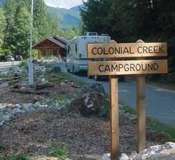
Campsites at Colonial Creek South Campground (2026 Guide)
7 min read
The Diablo Lake boat launch at Colonial Creek South is not usable for most powerboats. Silt has filled in the launch area.
For more, see Campsites at Gorge Lake Campground (2026 Guide).
For more, see Campsites at Lakeview Campground (2026 Guide) and Campsites at Lower Goodell Group Campground (2026 Guide).
For more, see Campsites at Harlequin Campground (2026 Guide).
For more, see Newhalem Creek Campground at Newhalem Creek Campground North Cascades National Park (2026 Guide).
For more, see Best of North Cascades National Park: Best Month to Visit (2026) and North Cascades National Park Weather: Best Season to Visit (2026 Guide).
For more, see complete visitor guide, all campgrounds, hiking trails, lodging and accommodations, Goodell Creek Campground at Goodell Creek Campground North, and Purple Point Campground at Purple Point Campground North.
What Makes This Campground Different
Most campgrounds in North Cascades National Park Complex sit along the same stretch of highway, but colonial creek south campground has a few specific traits that set it apart. It is the primary access point for Diablo Lake's south shore, which means you get a fully accessible fishing pier and a boat launch right at the campground. The boat launch has a problem worth noting - the Diablo Lake boat launch at Colonial Creek South is not usable for launching most powerboats due to silt accumulation. Expect shallow or no water at the ramp. You may need to carry your boat to or from the water.
The campground sits in old growth forest, which means real shade in summer and damp conditions in spring and fall. The ten winter sites (64-73) are walk-in and tent-only, which keeps the RVs and trailers out of that section entirely. During winter, there is no potable water, no trash service, and no fee. Vault toilets remain available. Snow may be on the ground, and sites can be difficult to access.
Site Selection Strategy
The campground has 93 total sites, with 19 designated as tent-only. The walk-in sites 64-73 are the ones that stay open through winter. The remaining sites are reservable during peak season. If you are booking for summer, the reservation window opens six months in advance at Recreation.gov, and you can also book as little as seven days ahead. Check-out is noon.
Rangers will tell you that sites closest to the water fill first, and for good reason. The lake access and the fishing pier are the main draws here. The Thunder Creek and Thunder Knob trailheads are also accessible from the campground, which means you can hike without moving your vehicle. Given the break-in warnings along SR 20 - smash-and-grab theft is not uncommon at trailheads - leaving your car at your campsite instead of at a trailhead parking lot is a genuine advantage.
Seasonal Operations and Fees
The fee structure at colonial creek south campground changes three times a year. Understanding which period applies to your visit saves confusion at the pay station.
Summer Reservation Season (Late May to Mid-September)
- Fee: $24 per site per night
- Reservation required: Yes, through Recreation.gov or by phone at (877) 444-6777
- Occupancy limits: 2 vehicles, 8 people, 3 tents per site
- Check-out: 12:00 PM
This is the only period when the full campground is open. Water and trash services are provided. The boat launch, fishing pier, and trailheads are all operating at full capacity, minus the silt issue at the boat ramp.
Fall First-Come, First-Served (Early September through October)
- Fee: $24 per site per night
- Payment: Through pay.gov at tinyurl.com/NOCACamping
- Services: Potable water and trash services still provided
This period starts once reservations end in early September and continues through October. Same fee, same services, but you cannot reserve. Show up and claim an open site. Weekdays are generally easier than weekends.
Winter Season (October to Late May)
- Fee: $0
- Sites available: 64-73 only (walk-in, tent-only)
- Services: None. No water. No trash pickup.
- Toilets: Vault toilets available
- Snow: Possible on ground. Sites may be difficult to access.
Ten sites, no fee, no services, no reservations. You carry in everything you need and carry out all your trash. This is bare-bones camping for people who know what they are doing. The research data indicates the winter season runs October to late May, and per the NPS hours data, the winter exception runs from September 15 through May 20. The exact transition dates vary slightly by year, so check the official website for current dates.
Current Conditions and Alerts (May 2026)
The research data includes nine active alerts for North Cascades National Park Complex. Several directly affect colonial creek south campground.
SR 20 Closure at Milepost 130
State Route 20 is closed at milepost 130 - that is the Colonial Creek Campground location - in both lanes. The Diablo Lake Overlook is not accessible beyond the closure. This is the most consequential alert for anyone planning to visit. The WSDOT real-time map is the best source for updates. If you are approaching from the west, you may not be able to reach the campground at all. If you are already in the area, confirm the road status before departing.
Boat Launch Silt Accumulation
The Diablo Lake boat launch at Colonial Creek South is not usable for most powerboats. Silt has filled in the launch area. You may find shallow or no water at the ramp. Expect to carry your boat to or from the water if you plan to launch anything. This is not a temporary repair situation - it has been an ongoing condition.
Break-in Warning Along SR 20
Break-ins are not uncommon at trailheads along State Route 20. Remove valuables and electronics from your vehicle, and take any associated charging cords. Smashed windows are the typical result of leaving items visible. The campground itself is generally safer than the trailhead parking lots, but do not assume your car is immune anywhere along this corridor.
Flooding and Landslide Damage
The park complex experienced severe weather events following flood damage in December 2025. Unsafe conditions persist in some areas, and basic infrastructure is limited. Stehekin, in particular, is prone to flash floods and debris flows, especially in post-fire terrain. Colonial Creek South itself is not in the Stehekin area, but the broader park conditions mean that services and road access may be unpredictable.
Hiking and Recreation
Two primary trails are accessible from the campground.
Thunder Creek Trail follows Thunder Creek through old growth forest. It is a longer, flatter route suitable for day hikes or overnight backpacking if you connect to the backcountry. The trail register at the trailhead will give you current conditions.
Thunder Knob Trail is a shorter, steeper option that climbs to a viewpoint overlooking Diablo Lake. Early morning is your best bet for clear views before afternoon clouds build in. The elevation gain is worth it - from the top you can see the full expanse of Diablo Lake and the surrounding peaks.
The accessible fishing pier is a notable feature. It provides lake access for anglers and visitors with mobility limitations. The pier is on Diablo Lake, and the fishing is typical for North Cascades waters - think trout and kokanee.
Practical Takeaways
- Check SR 20 status before driving. The closure at milepost 130 may prevent access entirely. Use the WSDOT real-time map.
- Book summer reservations at Recreation.gov. Six months in advance for peak dates. $24 per night. Reservation required late May through September.
- Winter camping at sites 64-73 is free but spartan. No water. No trash service. Vault toilets only. Pack out everything.
- The boat launch is unreliable for powerboats. Silt accumulation means you may need to carry your boat. Canoes and kayaks are more manageable.
- Do not leave valuables in your vehicle at trailheads. Break-ins are common along SR 20. Take everything with you.
- Fall camping (September to October) is first-come, first-served. Same $24 fee, but no reservation. Pay through pay.gov.
- Cell service drops out along much of SR 20 through this area. Download maps and reservation confirmations before you lose signal.
Final Thoughts
Colonial Creek South Campground offers something unusual in the national park system: a genuine seasonal transition from full-service reservation camping to free winter walk-in sites. That flexibility is rare and worth using if your schedule allows shoulder-season visits. The catch, as of 2026, is the road closure and the broader flood-related infrastructure issues affecting the park complex. Anyone who has driven SR 20 in the spring knows that road conditions change fast. The common mistake - and almost everyone makes it - is assuming the highway will be open because it is May. Check first. The campground will be there waiting when the road is open, and the fishing pier and trails make it one of the more complete basecamp options in this part of the North Cascades. For a full breakdown of all campgrounds in the area, check the all campgrounds page.
Sources
- Official source: NPS — North Cascades National Park nps.gov/noca/index.htm
- Official booking/facility record recreation.gov/camping/campgrounds/255201
More to Explore

Acadia National Park: Carriage Roads, Cadillac Mountain & 2026 Guide
Discover carriage roads, Cadillac Mountain, and rugged Maine coast. Complete 2026 guide to Acadia National Park — trails, fees, lodging, permits, and what rangers recommend.

Grand Canyon Hiking Trails: Day Hikes, Water Sources & Rim to Rim
Compare Grand Canyon hiking trails: Bright Angel, South Kaibab, Hermit, Grandview, and rim to rim, with distances, elevation, water stops, and trailhead access for each.

Best of Glacier Bay National Park
The best of Glacier Bay is reached by boat: ranger-led day tours up the bay to the tidewater glaciers. What's worth it, how to book, and when to go (2026).

White Sands Backcountry Camping: Closed for 2026 — What to Know
As of 2026, backcountry camping at White Sands National Park is closed for site rehabilitation. What that means, and where to camp nearby instead.

Guadalupe Mountains National Park Weather: Weather
Guadalupe Mountains National Park: weather guide guide updated 2026. Practical visitor information, reservations, and seasonal tips worth bookmarking before

Best of Cuyahoga Valley National Park: Best Things to Do
Seeing a Cleveland Orchestra concert with the woods as your backdrop is a uniquely Cuyahoga Valley experience.
Sign in to join the conversation.
Sources & Attribution
Location data courtesy of the National Park Service (U.S. Department of the Interior). NPS data is public domain. Official NPS page.
Images: NPS.
Map data © OpenStreetMap contributors.
Park operations alerts: NPS.gov · Weather and weather hazards: National Weather Service · Live conditions.
Information may change. Always verify fees, hours, and conditions directly with the official source before visiting.
Did this guide help? Share it with a friend.