Bear Lake Road terminates 9.2 miles from its junction with Trail Ridge Road at a parking area, followed by a short, marked path to the lake. That's the basic logistics. What you'll find is a 9,475-foot alpine basin where the water perfectly reflects Hallett Peak and the Continental Divide. This location serves as the trailhead for several premier hikes in Rocky Mountain National Park and offers an accessible loop trail. Based on two decades of observing visitor patterns, I can tell you that understanding the parking situation is the most critical piece of planning for your visit.
NPS via NPS.gov (Public Domain)
Bear Lake: bear lake: Complete Guide (2026)
9 min read
Places & Points of Interest
Plan your 2026 visit to Bear Lake. Complete guide to trails, fees, lodging, best time to visit, and insider tips.
Your plans
Quick Information
- Entrance Fee: Access requires a valid Rocky Mountain National Park entrance pass. As of 2026, a 1-day vehicle pass is $35. An annual park pass is $70. The America the Beautiful Annual Pass ($80) also covers entry.
- Hours: Bear Lake Road is open 24 hours a day, year-round, but is subject to closure due to snow. The parking lot typically fills by 7:30 AM from late May through September.
- Best Time to Visit: Early morning, year-round. For fewer crowds and stable weather, target weekdays in September or late May.
- Location: Rocky Mountain National Park, Colorado. Nearest town is Estes Park. GPS coordinates are 40.31193867, -105.64571617.
- Accessibility: The first 100 yards of the path from the parking lot to the lake shore is paved and wheelchair/stroller accessible. The full loop trail is not ADA-compliant.
- Cell Service: Spotty to non-existent. Assume you will have no signal at the lake or on any connecting trails.
- Restrooms: Vault toilets are available at the Bear Lake Trailhead parking area. No running water.
- Parking: One large lot with approximately 200 spaces. It fills exceptionally fast. A park shuttle operates from late May to early October from the Park & Ride lot 5 miles down Bear Lake Road.
Getting There
From Estes Park, take US Highway 36 west to the Beaver Meadows Entrance Station. After paying the entrance fee, turn left onto Bear Lake Road almost immediately. Follow this winding, scenic road for 9.2 miles to its terminus at the Bear Lake parking area. The drive from the entrance station takes about 25 minutes without traffic, longer if you get stuck behind cyclists or wildlife viewers.
From Denver International Airport, expect a 2 to 2.5 hour drive via I-25 North, US 36 West through Lyons, and CO Highway 66 into Estes Park.
The parking strategy is non-negotiable: arrive before 7 AM or plan to use the shuttle. Rangers will tell you the lot is often full by sunrise on summer weekends. The free Hiker Shuttle runs from the Estes Park Visitor Center and the Park & Ride lot on Bear Lake Road. Park your car at the Park & Ride (it fills later than the main lot) and take the 15-minute shuttle ride to the trailhead. It runs frequently, but lines form. Early morning is your best bet for a shorter wait.

What to Expect
At 9,475 feet, the air is thin and dry, carrying the distinct scent of pine and cold stone. The lake forms a 0.7-mile loop around a basin of remarkably clear, green-tinted water. In the early hours, the surface often becomes perfectly still, producing that iconic reflection of Hallett Peak's granite face—a sight I've documented in field guides for years.
The trail narrows here as it circles the lake, transitioning from a wide, packed gravel path to boardwalks over wetland areas and rocky, rooted sections under the shade of subalpine fir and Engelmann spruce. The sound is a mix of wind through the evergreens, the chatter of gray jays (also called camp robbers), and the distant thwack of trekking poles on rock from hikers heading to Emerald or Dream Lake.
Most first-time visitors are caught off guard by two things: the sheer number of people on the easy loop, and the immediate, tangible drop in temperature when you step into the shade. The sun at this altitude is intense; the shade can be 15-20 degrees cooler. Dress in layers you can shed and add back quickly.
From this overlook you can see the entire Tyndall Gorge, the U-shaped valley carved by glaciers that leads your eye up to Flattop Mountain and Hallett Peak. It's a textbook alpine scene, and that's why it's crowded. The common mistake is to do only the loop. The trailhead is the true gateway. Experienced visitors know to walk the loop for the view, then immediately head out on one of the connecting trails to find solitude.
Top Attractions & Points of Interest
Bear Lake Loop
The 0.7-mile loop is the main event for many. It's flat, gaining only about 20 feet in elevation, and offers constantly shifting perspectives of Hallett Peak across the water. Benches are placed at strategic viewpoints. The west side of the loop tends to be more crowded; the east side, with its boardwalks over the inlet stream, feels quieter. Do it clockwise to get the classic reflection shot with the peak early in your walk.
The Bear Lake Trailhead Network
This isn't a single attraction but the launch point for the park's most famous chain of lakes. From this one parking area, you can access trails to Nymph, Dream, Emerald, Haiyaha, and Bierstadt Lakes, as well as the climb to Flattop Mountain. The trail register here is full of comments about the altitude and the payoff. It's the most concentrated network of alpine destinations in the park.
Hallett Peak Reflection
The postcard view. For the best reflection, you need two things: very early morning and absolutely no wind. The lake surface is often like glass until 8 or 9 AM. The best vantage point is from the rocky outcrops on the northern side of the loop, near the trail junction for the other lakes. After the sun hits the water and the breeze picks up, the mirror effect shatters.
Nymph Lake
A 0.5-mile, steady climb from Bear Lake brings you to this smaller, lily-pad covered pond. It's the first stop on the way to Dream and Emerald Lakes. In summer, the yellow pond lilies are in bloom. It's a good turnaround point for those wanting a short hike with a bit of elevation gain (about 225 feet).
Dream Lake
Another 0.6 miles beyond Nymph Lake, Dream Lake is a long, narrow alpine lake framed by Hallett Peak and Flattop Mountain. The trail between Nymph and Dream involves some rocky steps and a steeper pitch. The view from the east end of Dream Lake, looking back down its length toward the peaks, is one of the park's most photographed scenes. It's 1.1 miles one-way from the Bear Lake Trailhead.

Activities
Hiking
This is the primary activity. The hiking trails radiating from Bear Lake cater to all levels, but all start at high elevation.
- Easy: The Bear Lake Loop (0.7 miles). Pack extra water for this stretch if you're not acclimated; even flat walking at 9,500 feet is work.
- Moderate: The hike to Emerald Lake (3.6 miles round trip, 771 feet of gain). It passes Nymph and Dream Lakes. The elevation gain is worth it for the view of the glacial cirque holding Emerald Lake.
- Strenuous: Flattop Mountain (8.8 miles round trip, 2,849 feet of gain). This takes you to the Continental Divide. Rangers will tell you to be off the summit by early afternoon due to lightning risk.
Photography
Early morning provides the best light, hitting Hallett Peak directly and creating the famous reflection. By midday, the light is harsh and the peaks are backlit from the lake perspective. Late afternoon can work, but the sun drops behind the Continental Divide early, plunging the basin into shadow. A polarizing filter helps cut the glare off the water.
Wildlife Viewing
While the lake itself is often too busy for larger mammals, the surrounding forests are active. Keep an eye out for Clark's nutcrackers, Steller's jays, and red squirrels. Mule deer are occasionally seen at the forest edges at dawn and dusk. For dedicated wildlife viewing, you'll have better luck in the meadows along Bear Lake Road on your drive in or out.
Winter Activities
From late October through May, expect deep snow. The loop becomes a snowshoe or cross-country ski track. Hiking with traction devices like microspikes is essential - the path becomes a hard-packed, icy sidewalk. Snowshoeing to Nymph or Dream Lake is a popular winter adventure, but avalanche awareness is required for terrain above and around the lakes. Check the park's "Be Avalanche Aware" bulletins.
Seasonal Guide
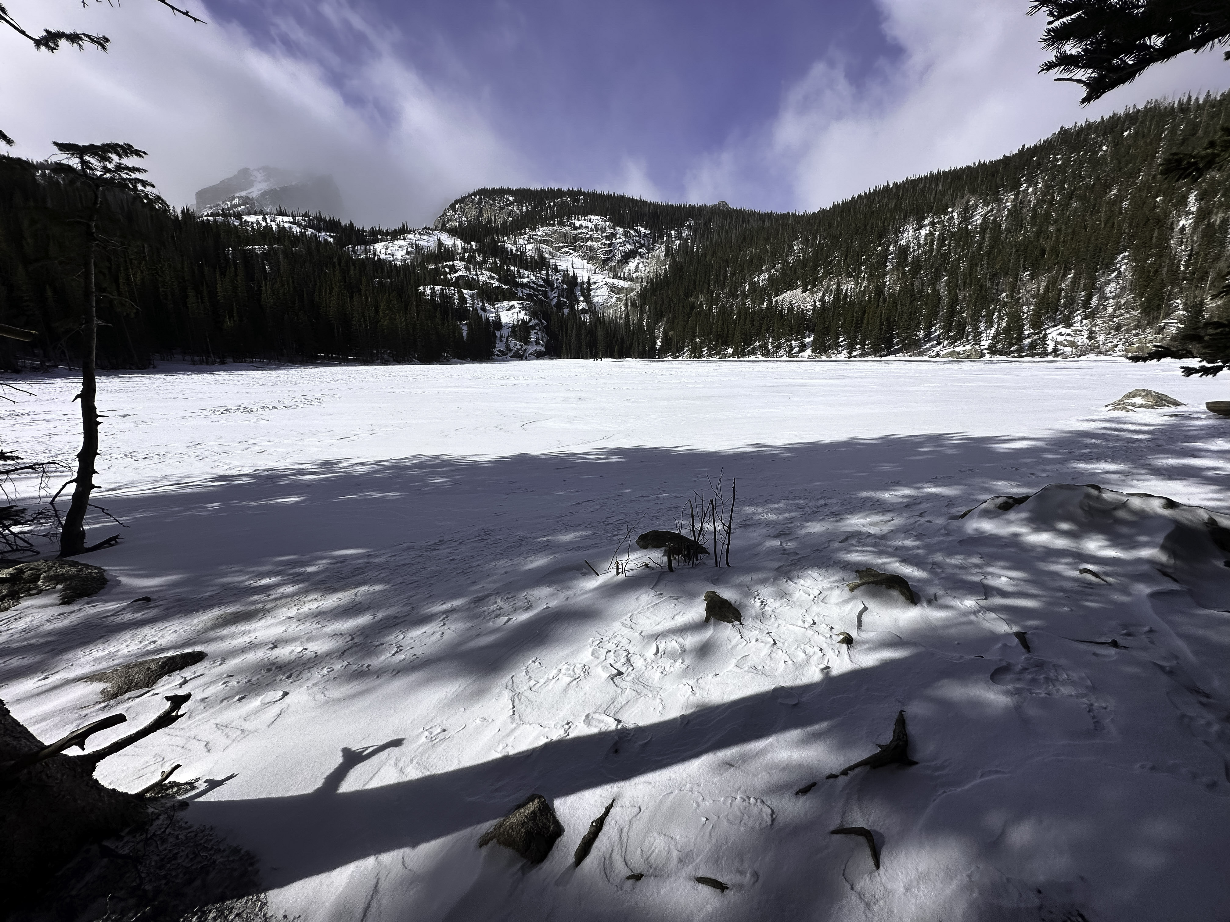
- Winter (Dec - Mar): Cold, snowy, and quiet. The road is plowed but can close during storms. Traction devices are mandatory. The lake is frozen and snow-covered. Parking is easy to find.
- Spring (Apr - May): Unpredictable. Snow melts at the lake shore but lingers heavily on trails above. The loop may be a mix of mud, ice, and slush. Trail conditions change daily.
- Summer (June - Aug): Peak visitation. Wildflowers bloom in July. Afternoon thunderstorms are a daily occurrence from about 1 PM onward. Start your hike early to be back below tree line by noon. The parking lot is full by sunrise.
- Fall (Sep - Nov): The best balance. Crowds diminish after Labor Day. September offers stable weather and golden aspen groves along Bear Lake Road. Snow can arrive as early as October. Mornings are crisp.
For a detailed monthly breakdown, see our guide on the best time to visit.

Practical Information
A timed entry permit is required to access the Bear Lake Road Corridor from late May through October. This is in addition to your park entrance fee. You must reserve a 2-hour entry window in advance at Recreation.gov. No permit is needed if you enter the corridor before 5 AM or after 6 PM.
For camping options, the nearest campgrounds are Moraine Park and Glacier Basin. Both are often booked months in advance for summer. As of 2026, Moraine Park is $35 per night. There are no lodges or restaurants at Bear Lake. The nearest food and gas are in Estes Park. Pack all water and snacks you'll need for the day.
If you're looking for lodging and accommodations, Estes Park is your basecamp, offering everything from hotels to cabins.
Safety & Preparation
- Altitude: You are at nearly 9,500 feet. Headaches, nausea, and shortness of breath are common. Acclimate in Estes Park (7,500 feet) for a day if possible. Drink twice as much water as you think you need.
- Weather: It can snow any month of the year. Afternoon thunderstorms bring lightning, hail, and rapid temperature drops. Be off high, exposed trails by early afternoon.
- Wildlife: Do not approach elk or moose, especially during fall rut. Store all food and trash in your vehicle to avoid attracting bears.
- Trail Conditions: In spring and early summer, trails above the lake can be covered in steep snowfields (called "monorails") that require technical skill to cross. Turn around if you're uncomfortable.
- Emergency: Cell service drops out at the trailhead. Rangers patrol but are not everywhere. Know your limits. The nearest emergency services are in Estes Park.

Insider Tips
- The Shuttle Secret: If the Park & Ride shuttle line is long, consider driving to the Glacier Gorge Trailhead parking lot (smaller, fills slightly later) and hiking the 0.5 miles from there to Bear Lake via a connecting trail. It's a strategic backdoor.
- Skip the Midday Rush: If you arrive late morning and the lot is full, don't waste hours waiting. Drive back down Bear Lake Road to the Sprague Lake turnoff. Do that easy, scenic loop, have a picnic, then try for Bear Lake again after 3 PM when the early hikers are leaving.
- The Better Reflection Spot: Everyone clusters at the first viewpoint on the north shore. Walk another 200 yards east on the loop to a less crowded rocky peninsula. The reflection is just as good, if not better.
- Winter Parking is Different: In winter, the Park & Ride shuttle doesn't run, and the Bear Lake lot is often only partially plowed. Arrive by 8 AM to get a spot on weekends. The road is well-maintained, but have all-wheel drive or 4WD and carry tire chains.
- What the Website Doesn't Mention: The vault toilets at the trailhead have no hand sanitizer. Bring your own. Also, the informational signs at the lake are excellent for understanding the glacial geology you're seeing - take two minutes to read them.
- For True Solitude: The Bear Lake loop will never be empty. But if you hike just 0.3 miles up the trail toward Bierstadt Lake (a left at the first major junction), the crowd noise vanishes completely. You don't have to go all the way to the lake to find quiet.
- Post-Hike Reward: The gift shop at the Beaver Meadows Visitor Center sells water for $4 a bottle. Fill up your own at the free water bottle filling station inside the visitor center instead.
For more information, see our complete Rocky Mountain National Park Guide.
Sources
- Official source: NPS — Rocky Mountain National Park nps.gov/romo/index.htm
- Official source: National Park Service nps.gov/places/bear-lake.htm
Photo Gallery
More to Explore

Park Guide
Acadia National Park: Carriage Roads, Cadillac Mountain & 2026 Guide
Discover carriage roads, Cadillac Mountain, and rugged Maine coast. Complete 2026 guide to Acadia National Park — trails, fees, lodging, permits, and what rangers recommend.

Hiking Guide
Grand Canyon Hiking Trails: Day Hikes, Water Sources & Rim to Rim
Compare Grand Canyon hiking trails: Bright Angel, South Kaibab, Hermit, Grandview, and rim to rim, with distances, elevation, water stops, and trailhead access for each.

Best Of
Best of Glacier Bay National Park
The best of Glacier Bay is reached by boat: ranger-led day tours up the bay to the tidewater glaciers. What's worth it, how to book, and when to go (2026).

Campsite Guide
White Sands Backcountry Camping: Closed for 2026 — What to Know
As of 2026, backcountry camping at White Sands National Park is closed for site rehabilitation. What that means, and where to camp nearby instead.

Weather Guide
Guadalupe Mountains National Park Weather: Weather
Guadalupe Mountains National Park: weather guide guide updated 2026. Practical visitor information, reservations, and seasonal tips worth bookmarking before

Best Of
Best of Cuyahoga Valley National Park: Best Things to Do
Seeing a Cleveland Orchestra concert with the woods as your backdrop is a uniquely Cuyahoga Valley experience.
Sign in to join the conversation.
Sources & Attribution
Location data courtesy of the National Park Service (U.S. Department of the Interior). NPS data is public domain. Official NPS page.
Images: NPS; NPS; NPS; NPS; NPS.
Map data © OpenStreetMap contributors.
Park operations alerts: NPS.gov · Weather and weather hazards: National Weather Service · Live conditions.
Information may change. Always verify fees, hours, and conditions directly with the official source before visiting.
Did this guide help? Share it with a friend.