New River Gorge National Park: Whitewater, Rock Climbing & Wild West Virginia - 2026 Guide
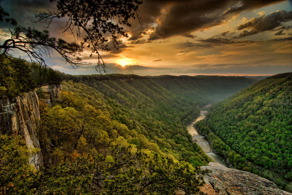
NPS via NPS.gov (Public Domain)
Where to See New River Gorge Bridge
11 min read
Park Guide
The best time to visit for reliable weather and full activity access is June through September, though whitewater rafting peaks in the spring runoff.
Your plans
This article contains affiliate links — we may earn a small commission at no extra cost to you.
At a glance
Hours
The park itself is open 24 hour a day, year round. The park's two main visitor centers at Canyon Rim
Best Time
June-September (summer), September-October (fall colors)
Address
104 Main Street, Glen Jean, WV, 25846
Website
37.8688, -80.9996
Google MapsFlow reliability
Seasonal consistency of median discharge from the curated USGS gauge for this place.
Spring
68%
year-to-year consistency
Summer
73%
year-to-year consistency
Fall
22%
year-to-year consistency
Winter
62%
year-to-year consistency
Median monthly discharge (cfs)
| Jan | Feb | Mar | Apr | May | Jun | Jul | Aug | Sep | Oct | Nov | Dec |
|---|---|---|---|---|---|---|---|---|---|---|---|
| 8195 | 14800 | 10600 | 10600 | 9860 | 5585 | 3885 | 3755 | 2730 | 2750 | 3695 | 6330 |
In the last 10 falls, roughly 1 of every 3 September–November weeks sat inside this band (3370–11800 cfs); typical flow in those weeks 5545 cfs, median water temp 64°F (17.5°C).
Computed from 10 years of USGS daily records, station 03185400 (3,651 daily values). Last computed Oct 19, 2026.
Hydrological description only — not advice about wading, floating, or whether conditions are safe for recreation. Always check current USGS readings and local guidance before you go.
The New River presents a geological puzzle, carving its northward course through the younger Appalachian Mountains as one of the continent's oldest waterways. Since its 2020 designation as a National Park & Preserve, this 70,000-acre expanse protects West Virginia's most formidable terrain. While visitors often ask about viewing angles for the bridge, the true character of this place lies in the river itself—53 miles of untamed whitewater, sandstone cliffs with more than 1,400 established climbs, and a landscape deeply marked by coal mining history. This park rewards active engagement far more than passive observation.
Quick Information
There is no entrance fee to visit New River Gorge National Park & Preserve. The park is open 24 hours a day, year-round. The two main visitor centers at Canyon Rim and Sandstone are open daily from 9:00 AM to 5:00 PM, closing only on Thanksgiving, Christmas, and New Year's Day. Seasonal centers at Thurmond and Grandview typically operate from Memorial Day to Labor Day.
The best time to visit for reliable weather and full activity access is June through September, though whitewater rafting peaks in the spring runoff. Fall, particularly late September to October, brings spectacular color to the deciduous forests. The park is located in southern West Virginia, with Park Headquarters at 104 Main Street in Glen Jean. GPS coordinates for the headquarters are 37.92775° N, 81.15587° W. Cell service is notoriously spotty throughout the gorge and often drops out completely on backroads and trails. Plan to download maps and information ahead of time.
Parking varies widely. The main lots at Canyon Rim Visitor Center and popular trailheads like Endless Wall fill by 9 AM on weekends from spring through fall. Restrooms are available at the main visitor centers and some larger trailheads, though many are vault toilets. The park offers several accessible facilities, including the Canyon Rim Boardwalk (upper level) and the fully accessible Sandstone Falls Boardwalk.
Seasonal Guide
Spring (April-May): Water is king. The river runs high and cold, ideal for expert whitewater rafting. Waterfalls are at their peak. Trails can be muddy, and ticks are active. Crowds are lighter until Memorial Day. The forest greens up rapidly in May.
Summer (June-August): Peak visitor season. All facilities are open, including seasonal visitor centers. The river levels drop, making it suitable for beginner rafting and swimming in calmer areas. It's hot and humid in the gorge, but often pleasant on the rims. Afternoon thunderstorms are frequent. This is the best time for wildlife viewing, especially for birding.
Fall (September-October): Arguably the best time to visit. Crowds diminish after Labor Day, but the foliage peaks in mid-to-late October, especially at higher elevations like Grandview. Temperatures are crisp, perfect for hiking. Water levels are often low, revealing more rock features in the river.
Winter (November-March): The park is quiet. Some roads, like Fayette Station, may close temporarily due to ice. The visitor centers have reduced hours. It's a stark, beautiful time for photography, with bare trees revealing long views of the gorge and bridge. Ice forms on the cliff bands - a reminder that climbing is a three-season activity here for most.

Getting There
Most visitors arrive via Interstate 64 or Route 19. The park is decentralized, with different sections accessed from different towns. For the bridge and central climbing areas, aim for the Canyon Rim Visitor Center near Fayetteville. From Beckley, take Route 19 North to the Glen Jean exit for park headquarters, or continue to Lansing for the bridge. Drive time from Charleston is about 1 hour; from Roanoke, VA, it's about 2 hours.
A critical note: third-party map apps sometimes direct people to remote, inaccessible parts of the park with no services. For reliable directions, use the addresses for the Canyon Rim or Sandstone Visitor Centers as your destination. The scenic drive on Fayette Station Road provides the classic under-the-bridge perspective, but it's a narrow, winding road not suitable for large RVs.
What to Expect
Prepare for a landscape defined by extremes. Wooded ridges offer mild temperatures, but descend just a few hundred feet into the gorge and you'll find still air that's often ten degrees warmer. The terrain demands respect—a short map distance frequently translates to switchbacks descending sandstone cliffs. Your ears will tell the story too, shifting from hemlock winds to Class V rapids, then to the profound quiet of old-growth forest.
First-time visitors consistently underestimate the scale and the drive times between sections. The park is long and narrow, following the river. Getting from the bridge area to Sandstone Falls can take over an hour. You'll also notice the layers of history: ghost towns like Thurmond, coke ovens from the Brooklyn Mine, and the ever-present reminder of the coal industry that once dominated these hollows. The weather changes quickly. A sunny ridge can be shrouded in fog an hour later, and afternoon thunderstorms boil up with little warning in the summer.

Top Attractions & Points of Interest
New River Gorge Bridge
This is the iconic postcard view, but the engineering is what sticks with you. The bridge is 3,030 feet long and the arch spans 1,700 feet. It sits 876 feet above the river. The most popular and accessible view is from the Canyon Rim Visitor Center boardwalk. The upper level is an easy, paved path to the main overlook. For the more dramatic view, take the stairs or ramp down to the lower overlook - you'll feel the hum of traffic above and get a true sense of the drop. For the definitive answer on where to see New River Gorge Bridge from below, drive Fayette Station Road.
Endless Wall Trail
This isn't just a hike; it's a pilgrimage for climbers and sightseers. The 2.4-mile point-to-point trail runs along the rim of the gorge, with constant views through the trees to the river below. The trail narrows here at several points where it skirts the cliff edge. The payoff is Diamond Point, a rocky promontory with a 180-degree view. The parking situation here is tight at the Fern Creek and Nuttall trailheads. Most hikers spot a car or arrange a shuttle.
Sandstone Falls
The largest waterfall on the New River, spanning 1,500 feet across. It's a wide, cascading fall rather than a single drop. Access is via a short, fully accessible boardwalk that gets you right to the edge of the island overlooking the falls. The power and noise are impressive at high water in spring, but it's beautiful year-round. It's in the southern section of the park, so plan the drive accordingly.
Grandview Main Overlook
This is the highest point in the park, offering a sweeping view of the river's horseshoe bend. It's particularly at sunset. The area has several easy trails, like the Big Buck Trail, that explore the rim. It feels different from the deep gorge near the bridge - more panoramic, less vertiginous.
Thurmond Historic District
A preserved ghost town and a stark lesson in history. Thurmond was once a booming railroad town where the coal from dozens of mines was loaded onto trains. Today, you can walk past the vacant depot, the boarded-up bank, and imagine the noise and soot that once filled this narrow hollow. The seasonal visitor center here is small but informative.
Fayette Station Road
More than just a way to get under the bridge, this is a historic drive that traces the original road across the river. It's a one-lane, winding route with pull-offs for views of the bridge from below. You'll cross the old Tunney Hunsaker Bridge at the bottom. Drive it slowly. The contrast between the modern engineering above and the old road you're on is the whole point.
Brooks Overlook
A quiet spot near Sandstone Falls that's a favorite for eagle watchers. A pair of bald eagles nests nearby, and with patience and binoculars, you might see them. The overlook peers toward Brooks Island, a mile-long island in the river. It's a quick, five-minute stop that often yields a memorable wildlife sighting.
Castle Rock Trail
For a short but intense dose of the park's geology, this 0.6-mile strenuous hike gets you up close to the sandstone cliffs. The trail is uneven, requires some scrambling, and ends at the base of towering rock formations. It's not for everyone, but it gives you a climber's-eye view of the rock texture and structure.
Activities
Whitewater Rafting and Paddling
This is the park's signature adrenaline activity. The New River is divided into the Upper (milder) and Lower (more intense) sections. The Lower Gorge, with its Class III-V rapids, is one of the premier whitewater destinations in the East. Spring offers the biggest water from snowmelt and rain. Multiple licensed outfitters operate outside the park; you cannot just show up with your own raft. Trips range from half-day to multi-day expeditions.
Rock Climbing
"The New" is a world-class climbing destination. The sandstone is generally solid, with a mix of traditional, sport, and boulder routes. The Endless Wall area is the most famous, but there are crags throughout the gorge. Climbers should be self-sufficient and familiar with the ethics and regulations, which include no new bolting. A guidebook is essential. The park service recommends checking in at the visitor center for current advice and conditions.
Hiking
With over 50 miles of trails, options range from easy riverside strolls to strenuous rim-to-river treks. The hiking trails network includes long-distance paths like the 5.6-mile Glade Creek Trail and the challenging Bridge Trail, which descends to the base of the gorge bridge. The Grandview Rim Trail is a 3.1-mile out-and-back that makes for an excellent trail run with consistent views. Always carry water - even short hikes can be steep and humid in the gorge.
Mountain Biking
The park offers over fifty miles of designated mountain bike trails, like the Arrowhead system. Terrain varies from smooth, crushed-rock paths to technical, rooty singletrack. The Brooklyn Mine Trail is a popular 2.7-mile one-way route. Bicycling is not permitted on all trails, so check the park map. The Cunard area is a primary hub for biking access.
Fishing
The New River is a renowned warm-water fishery, smallmouth bass being the premier target. Muskie, walleye, and various panfish are also abundant. Wading is possible in some areas, but a small boat or kayak vastly improves access. West Virginia state fishing licenses are required. The park's preserve designation means hunting is also permitted in specific zones during state seasons, a detail that surprises some visitors.
Scenic Driving
Beyond Fayette Station Road, the park's byways are attractions themselves. Route 82 along the southern end follows the river closely. The drive from Hinton to Sandstone Falls is particularly pretty. These roads are slow, winding, and demand your attention, but they're the best way to grasp the park's linear, river-focused geography.

Practical Information
Fees: No entrance fee. Some activities, like guided tours and guided experiences with outfitters, have separate costs. Camping in park campgrounds is free as of 2026, but sites are first-come, first-served.
Camping: The park manages several primitive, free campgrounds. These include Brooklyn (5 sites), Meadow Creek (26 sites), and Stone Cliff (7 sites). They are tent-only, have no hookups, and typically offer vault toilets. For more developed camping options with amenities, you'll need to look at private campgrounds in surrounding communities like Fayetteville or Hinton.
Lodging: There are no hotels or lodges within the park boundaries. For lodging and accommodations, you'll stay in gateway towns. Fayetteville is the hub for the bridge and climbing area, offering B&Bs, motels, and vacation rentals. Beckley, to the south, has more chain hotels. Hinton serves the southern end of the park.
Dining & Supplies: Options are limited within the park to vending machines at visitor centers. Fayetteville has a good selection of restaurants, cafes, and gear shops. Stock up on food, water, and gas before heading into more remote sections or to your campground.
Safety & Preparation
This is a rugged, remote-feeling park. Your safety is your responsibility. Always tell someone your plans. Weather changes fast in the mountains; carry rain gear and layers even on a sunny forecast. The river is powerful and cold; never underestimate its current. If you're on the water, wear a life jacket.
For hiking, wear sturdy footwear - the trails are rocky, rooted, and often steep. Carry more water than you think you need; a liter per hour of activity is a good rule in summer. Cell service drops out at most trailheads and is nonexistent in the gorge bottom. Poison ivy is abundant along trail edges. Learn to identify it.
In hunting seasons (fall and winter), wear bright orange if you're venturing into areas designated as National Preserve. Know where you are on the park map. In case of emergency, call 911. The park's primary non-emergency number is 304-465-0508.

Insider Tips
- Bridge Traffic Trick: The best time to photograph the bridge without vehicle haze is early on a Sunday morning. For the classic "bridge with river" shot from the Canyon Rim boardwalk, go within two hours of sunrise before the sun gets too high and creates deep shadows in the gorge.
- Endless Wall Shuttle: Don't fight for one parking spot. Have your group meet at the Nuttall Trailhead (lot is slightly larger), leave all cars there, and take one car to the Fern Creek Trailhead to start the hike. You'll finish at your vehicles.
- The Quiet Overlook: Everyone stops at the main Canyon Rim overlook. For a different, often solitary view of the bridge, pull into the turnout for the "Bridge Turnout" on Route 19, just north of the visitor center entrance. It's a simple roadside pull-off with a unique lateral perspective.
- Beat the Heat: If visiting in July or August, plan your hike for the early morning or focus on rim trails like Grandview or Endless Wall where you might catch a breeze. The gorge floor can feel like a steam bath in the afternoon.
- Check the River Gauge: If you're interested in rafting or even just river scenery, check the USGS river gauge for the New River at Thurmond. Under 2 feet is low; 3-5 feet is good for most recreational rafting; above 6 feet is high and expert-only. This tells you more than the weather forecast.
- Thurmond's Secret: The Thurmond depot has a working, old-fashioned water fountain inside. On a hot day after exploring, it's the coldest, best-tasting water in the park.
- Park Newspaper is Key: Grab the free "Park Guide" newspaper at any visitor center. It contains the most current map, lists all ranger programs for the season, and has a detailed driving tour guide you can follow. It's the single most useful piece of paper you'll get.
Links may earn us a commission at no extra cost to you. We only recommend gear we believe in. For hiking here, prioritize footwear with aggressive tread over lightweight shoes. The sandstone can be slick when dry and treacherous when wet. A pair of trekking poles will save your knees on the descents into the gorge and provide stability on rocky trails.
For more information, see our complete National Park & Preserve Guide.
Recommended Gear
What experienced visitors bring to Where to See New River Gorge Bridge
Links may earn us a commission at no extra cost to you. We only recommend gear we believe in.
Hiking Essentials
Hydration Pack (3L)
Hands-free water for long trail days
Trekking Poles (Pair)
Save your knees on steep descents
Hiking Boots (Ankle Support)
Sturdy footwear for rocky, uneven trails
Sun & Heat Protection
Wide-Brim Sun Hat
Full coverage UPF 50+ protection at altitude
Insulated Water Bottle (32oz)
Keeps water cold in desert heat all day
Winter Gear
Microspikes / Traction Devices
Essential for icy rim trails in winter months
Packable Down Jacket
Lightweight warmth that stuffs into a pocket
Sources
- Official source: NPS — New River Gorge National Park nps.gov/neri/index.htm
Explore More National Parks

Shenandoah National Park: Skyline Drive & Blue Ridge Views - 2026 Guide
Discover Skyline Drive, Blue Ridge views, and Appalachian trails. Complete 2026 guide to Shenandoah...

Great Smoky Mountains National Park: Complete Guide (2026)
Great Smoky Mountains National Park, America's most visited park, has no entrance gates but requires...

Cuyahoga Valley National Park: Ohio's River Valley Escape - Complete 2026 Guide
Cuyahoga Valley National Park: Ohio's River Valley Escape - Complete 2026 Guide Overview Why does th...

Congaree National Park: Ancient Floodplain Forest & Fireflies - 2026 Guide
Discover Congaree National Park national park guide with our comprehensive guide. Expert tips, pract...
Photo Gallery
More to Explore

Park Guide
Acadia National Park: Carriage Roads, Cadillac Mountain & 2026 Guide
Discover carriage roads, Cadillac Mountain, and rugged Maine coast. Complete 2026 guide to Acadia National Park — trails, fees, lodging, permits, and what rangers recommend.

Hiking Guide
Grand Canyon Hiking Trails: Day Hikes, Water Sources & Rim to Rim
Compare Grand Canyon hiking trails: Bright Angel, South Kaibab, Hermit, Grandview, and rim to rim, with distances, elevation, water stops, and trailhead access for each.

Best Of
Best of Glacier Bay National Park
The best of Glacier Bay is reached by boat: ranger-led day tours up the bay to the tidewater glaciers. What's worth it, how to book, and when to go (2026).

Campsite Guide
White Sands Backcountry Camping: Closed for 2026 — What to Know
As of 2026, backcountry camping at White Sands National Park is closed for site rehabilitation. What that means, and where to camp nearby instead.

Weather Guide
Guadalupe Mountains National Park Weather: Weather
Guadalupe Mountains National Park: weather guide guide updated 2026. Practical visitor information, reservations, and seasonal tips worth bookmarking before

Best Of
Best of Cuyahoga Valley National Park: Best Things to Do
Seeing a Cleveland Orchestra concert with the woods as your backdrop is a uniquely Cuyahoga Valley experience.
Sign in to join the conversation.
Sources & Attribution
Location data courtesy of the National Park Service (U.S. Department of the Interior). NPS data is public domain. Official NPS page.
Images: NPS; NPS; NPS; NPS; NPS.
Map data © OpenStreetMap contributors.
Park operations alerts: NPS.gov · Weather and weather hazards: National Weather Service · Live conditions.
Information may change. Always verify fees, hours, and conditions directly with the official source before visiting.
Did this guide help? Share it with a friend.