Start before 9 AM at the Canyon Rim Visitor Center, not because the exhibits demand a full hour, but because the parking lot fills by 9:30 on any decent weather day between April and October. This single piece of advice - arrive early - will shape your entire experience more than any trail recommendation. The park covers over 70,000 acres along 53 miles of free-flowing river, and the right basecamp town determines how much of it you actually see.
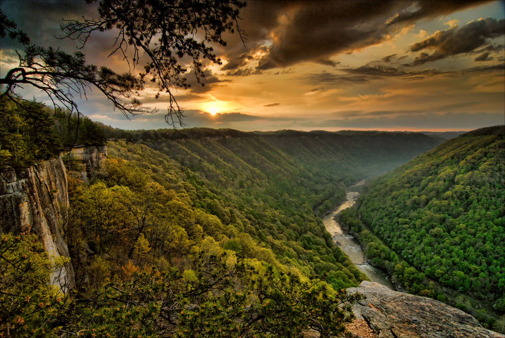
NPS via NPS.gov (Public Domain)
Best of New River Gorge National Park: Best Town Near (2026)
12 min read
Best Of
Discover best town near new river gorge national park with our comprehensive guide. Expert tips, practical information, and insider knowledge.
This article contains affiliate links — we may earn a small commission at no extra cost to you.
For more, see hiking trails, camping options, and best time to visit.
If you're looking for the best town near New River Gorge National Park, Fayetteville is the answer. It sits three miles from the Canyon Rim Visitor Center, has a walkable main street with actual restaurants (not just gas station pizza), and puts you within 20 minutes of the park's three best trailheads. Most visitors who stay in Beckley or Oak Hill spend an extra 30-45 minutes driving each day. That adds up.
For a complete overview of the park's layout and logistics, refer to the complete visitor guide before you arrive.
If You Only Have One Day
Arrive at the Canyon Rim Visitor Center by 8:30 AM. Hit the restrooms, grab a park newspaper, and walk the paved overlooks behind the building - you'll see the New River Gorge Bridge from above, 876 feet up. Most people stop here for photos and leave. Don't be most people.
From Canyon Rim, drive 10 minutes north to the Endless Wall Trail trailhead. Start hiking by 9 AM. The trail runs 2.4 miles one way along the cliff edge, with views dropping straight down into the gorge. You'll pass Diamond Point overlook about a mile in - this is the spot you've seen in photos, where the river bends hard south and the bridge frames the background. Take your photos and keep moving.
By 11:30, you'll hit the Fern Creek trail junction. Take the connector back to your car. Total distance: about 3 miles on a moderate grade. Your legs will feel it but not curse you.
Lunch in Fayetteville. The Cathedral Cafe on Court Street has sandwiches that justify the wait. Or grab a slice at Pies & Pints - they have a rooftop deck that fills fast.
Afternoon: drive the Fayette Station Road. This is a one-way, 8-mile loop that drops from the rim down to river level, passes under the bridge, and climbs back up. Allow 45 minutes with stops. The road is narrow in sections - single-lane with pullouts - but it gives you a perspective you cannot get from any trail. You'll see the bridge from below, the river at eye level, and the old Fayette Station bridge that carried traffic before 1977.
End the day at Grandview Main Overlook, 20 minutes south of Fayetteville. The horseshoe bend of the river catches late afternoon light better than any other spot in the park. Rangers will tell you sunset here is worth rearranging your schedule for. They're right.

The Top Experiences, Ranked
#1 - Endless Wall Trail: The Best Return on Effort in the Park
- Why it makes this list: You get 2.5 miles of continuous cliff-edge views without significant elevation gain. No other trail in the park delivers this much visual payoff per mile.
- What it requires: 2-3 hours, moderate fitness, decent footwear (the trail surface transitions from packed dirt to exposed sandstone in sections).
- The single best tip: Hike it east to west. Start at the Fern Creek trailhead parking, hike to the Endless Wall trail proper, and end at the Nuttall trailhead. You avoid the steepest climb and finish with the best views.
- What most visitors do wrong: They start at the main trailhead off Route 19, which means they're sharing the first half-mile with every family group and Instagram photographer in the park. The Fern Creek approach thins the crowd immediately.
- Rangers will tell you the trail gets 400+ visitors on summer Saturdays. If you cannot go midweek, arrive before 8:30 AM.
#2 - New River Gorge Bridge from Below: Fayette Station Road
- Why it makes this list: The bridge is the park's defining structure - 3,030 feet long, 876 feet above the river. Seeing it from above is impressive. Standing under it is something else entirely.
- What it requires: 45 minutes driving time, a vehicle with decent brakes, and patience for single-lane sections.
- The single best tip: Stop at the old bridge abutments midway down. There's a pullout on the left where you can park and walk onto the original 1889 bridge structure. The steel grid decking lets you see the river rushing below your feet.
- What most visitors do wrong: They drive it too fast. The road has 15 switchbacks and several blind corners. Going slow isn't optional - it's how you see the layers of sandstone and shale exposed in the road cuts.
#3 - Whitewater Rafting on the Lower New: The Signature Experience
- Why it makes this list: The New River is among the oldest rivers on the continent, and the lower gorge has Class III-V rapids through a deep canyon with no road access. You float through a stretch of river that looks the same now as it did 300 million years ago.
- What it requires: A full day (half-day options exist but skip the best rapids), reservation with a commercial outfitter, and willingness to get wet in water that stays in the 60s even in July.
- The single best tip: Book with an outfitter that launches from the Fayetteville area - Adventures on the Gorge and ACE Adventure Center both have solid reputations. Request a trip that runs the "Upper Lower" section, which includes the Class IV rapid called Keeneys.
- What most visitors underestimate: The drive out. After the trip, you're shuttled back to the outfitter in a bus, but your vehicle is at the put-in. Plan for a 30-minute shuttle wait at the end of a long day.
#4 - Grandview Rim Trail: The Best View for the Least Walking
- Why it makes this list: The main overlook at Grandview shows a 180-degree horseshoe bend of the New River from 1,400 feet elevation. It's the highest point in the park, and the trail is only 3.1 miles out and back.
- What it requires: 1.5-2 hours, easy to moderate fitness. The trail is mostly dirt with some exposed rock sections.
- The single best tip: Go in late afternoon. The sun angles across the horseshoe bend, and the shadows in the gorge make the rock layers pop. Early morning is backlit and flat.
- What most visitors do wrong: They stop at the main overlook platform and turn around. The trail continues another quarter-mile to a less-crowded viewpoint with an even better angle on the river bend.
#5 - Sandstone Falls Boardwalk: Accessible and Underappreciated
- Why it makes this list: This is the only wheelchair-accessible trail in the park that takes you to a major waterfall. The boardwalk runs about a half-mile through rhododendron thickets to a viewing platform above the falls.
- What it requires: 30 minutes, no fitness requirement, good for all ages.
- The single best tip: Visit in late May when the rhododendrons bloom. The purple and white flowers along the boardwalk are as striking as the waterfall itself.
- What most visitors do wrong: They skip it because it's in the southern section of the park, 30 minutes from Fayetteville. It's worth the drive, especially if you're already headed to Grandview.
#6 - Climbing at the New River Gorge: Over 1,400 Routes
- Why it makes this list: "The New" is one of the most popular climbing destinations on the East Coast. The Nuttall sandstone cliffs hold edges and crimps that climbers travel from across the country to test.
- What it requires: Full climbing gear, experience with multi-pitch anchors, and a willingness to hike 15-30 minutes to the cliff base.
- The single best tip: The Junkyard area (south of the bridge) has the best concentration of moderate routes in the 5.8-5.10 range. It's also where you'll find the shortest approaches.
- What most climbers get wrong: They underestimate the approach hike. Some crags require 45-minute descents on steep, loose trail. Bring more water than you think you need.
- Cell service drops out at several cliff areas. Download your route beta before you leave town.
#7 - Castle Rock Hike: Short, Steep, and Rewarding
- Why it makes this list: It's only 0.6 miles round trip, but it's listed as strenuous for good reason. The trail climbs over exposed sandstone slabs and requires using your hands on the final push to the summit.
- What it requires: 30-45 minutes, good ankle stability, and no fear of heights. The last 100 feet involve scrambling up rock faces with exposure on both sides.
- The single best tip: Go on a weekday morning. The trail is too narrow for passing comfortably, and on weekends you'll queue up at the scrambling sections.
- What most visitors do wrong: They attempt it after rain. Wet sandstone is dangerously slick, especially on the angled slabs near the top. If it rained in the last 24 hours, choose a different hike.
#8 - Burnwood Trail: The Old-Growth Forest You Didn't Know Was Here
- Why it makes this list: Most visitors come for the gorge views. They miss the 1.2-mile loop through one of the few remaining old-growth forests in West Virginia. The trail has interpretive stops explaining forest succession and tree aging - it's like a biology field course compressed into a 45-minute walk.
- What it requires: 45 minutes, easy walking, good for kids.
- The single best tip: Pick up the trail guide at the Canyon Rim Visitor Center before you go. The numbered stops correspond to a pamphlet that explains what you're looking at.
- What most visitors do wrong: They walk it without the guide. The trees look like trees unless someone tells you why the 300-year-old hemlock matters.
#9 - Thurmond: The Ghost Town That's Still Standing
- Why it makes this list: Thurmond was a railroad boomtown in the early 1900s, handling more freight than Cincinnati at its peak. Now it's a ghost town with a population of five, preserved by the NPS as a historic district.
- What it requires: 1-2 hours, a car to get there (the road follows the river from Route 41), and comfortable walking shoes for the boardwalk.
- The single best tip: The Thurmond Visitor Center is only open Memorial Day to Labor Day. If you visit in shoulder season, the buildings are still accessible from the outside, and the railroad tracks are active - freight trains rumble through several times daily.
- What most visitors do wrong: They expect a tourist attraction with vendors and activities. Thurmond is a preserved ruin. The appeal is the silence and the scale of what was lost.
#10 - Little Laurel Trail: The Quiet Alternative
- Why it makes this list: If Endless Wall is crowded, Little Laurel Trail is your backup. It's 4 miles round trip, strenuous, and sees a fraction of the traffic. The views are less dramatic but more intimate - you're walking through deep forest with occasional river glimpses through the trees.
- What it requires: 2-3 hours, good cardiovascular fitness (the return climb is unrelenting).
- The single best tip: Pack extra water for this stretch. The trail has no water sources and the south-facing slope bakes in afternoon sun.
- What most visitors do wrong: They underestimate the return. The trail drops 600 feet to the river. What goes down must come up, and the climb back is on loose gravel in exposed sections.

What Most People Miss
Brooks Overlook - About 10 minutes from the Sandstone Visitor Center, this pullout gives you a direct view of a bald eagle nest that's been active for years. The eagles return each spring to raise chicks, and the overlook has interpretive panels with a spotting scope. Most visitors drive right past because it's not on the main "must-see" lists. The best viewing is March through July.
Brooklyn Mine Trail - A 2.7-mile one-way hike that follows an old railroad grade to the ruins of the Brooklyn coal mining complex. The beehive coke ovens are still standing - stone structures that look like beehives where coal was baked into industrial fuel. The trail is moderate and follows the river, so you get water views the whole way. Most visitors never make it past the Canyon Rim area.
The park's night sky - New River Gorge is working toward International Dark Sky Park designation. On clear nights, the Milky Way is visible from the Grandview parking area with the naked eye. Rangers lead astronomy programs several weekends per month in summer. The park newspaper lists dates.
Sandstone Falls Overlook - The actual Sandstone Falls is downstream in the state park, but the NPS overlook gives you a view of the river widening into a mile-long series of rapids and small drops. It's a 5-minute stop that most people skip because the boardwalk gets all the attention.

What's Overrated (and Better Alternatives)
The Canyon Rim Visitor Center overlooks - They're fine. You get a good view of the bridge and the gorge. But they're also where every bus tour stops, where families with strollers congregate, and where the parking lot fills by 9:30 AM. The view from Diamond Point on the Endless Wall Trail is better, less crowded, and doesn't require sharing a railing with 40 other people.
The Bridge Walk catwalk - This commercial operation lets you walk on a catwalk beneath the bridge deck. It costs around $80 per person, takes 2-3 hours, and the novelty wears off after the first 10 minutes. If you want to see the bridge from below, drive Fayette Station Road for free. If you want the adrenaline, go rafting - same price, better experience.
Main Overlook at Grandview - Hear this out: the main overlook platform is crowded and the railing obstructs photos. The trail continues past the platform for another quarter-mile to an unofficial overlook that's better in every way - fewer people, no railings, and a direct sightline down the river bend. Keep walking.

Practical Takeaways
- Base yourself in Fayetteville. It's the best town near New River Gorge National Park for access, food, and lodging. The drive from Fayetteville to the Endless Wall trailhead is 8 minutes. From Beckley, it's 30. That difference matters when you're trying to beat the crowds.
- Book lodging six months out for summer and fall. The park gets over a million visitors annually, and Fayetteville's hotel rooms and vacation rentals fill up by March for June dates. If you're looking for hotels near New River Gorge National Park, the Fayetteville area has the best concentration, from the historic Lafayette Flats to budget-friendly chains near the Route 19 corridor.
- For camping near New River Gorge National Park, the NPS operates nine campgrounds, but only Army Camp and Glade Creek Campground have RV sites. The rest are tent-only, primitive, and free. For camping near New River Gorge WV with amenities, look at the commercial campgrounds on Route 19 - they have showers, electric hookups, and are closer to restaurants.
- The park has no entrance fee. This catches people off guard. New River Gorge is a National Park and Preserve, and as of 2026, there is no fee to enter. You pay for commercial services (rafting, climbing guides, the Bridge Walk) but the trails, overlooks, and visitor centers are free.
- Cell service is unreliable. It works at the Canyon Rim Visitor Center and in Fayetteville. It drops out on the Endless Wall Trail, at Grandview, and along most of Fayette Station Road. Download maps and trail information before you leave your lodging.
- The weather changes fast. The park sits in the Appalachian Mountains, and afternoon thunderstorms are routine from June through August. Rangers will tell you to start hikes early and be off exposed ridgelines by 2 PM. Pack a rain jacket even if the forecast says clear.
- Most visitors underestimate the scale. The park runs 53 miles along the river from Bluestone Dam to Hawks Nest Lake. Driving from Sandstone Falls to the Canyon Rim Visitor Center takes 45 minutes. You cannot see everything in one day. Pick two or three experiences from this list and do them well rather than trying to hit every overlook.
For more information, see our complete National Park & Preserve Guide.
Recommended Gear
What experienced visitors bring to Best of New River Gorge National Park: Best Town Near (2026)
Links may earn us a commission at no extra cost to you. We only recommend gear we believe in.
Hiking Essentials
Hydration Pack (3L)
Hands-free water for long trail days
Trekking Poles (Pair)
Save your knees on steep descents
Hiking Boots (Ankle Support)
Sturdy footwear for rocky, uneven trails
Sun & Heat Protection
Wide-Brim Sun Hat
Full coverage UPF 50+ protection at altitude
Insulated Water Bottle (32oz)
Keeps water cold in desert heat all day
Winter Gear
Microspikes / Traction Devices
Essential for icy rim trails in winter months
Packable Down Jacket
Lightweight warmth that stuffs into a pocket
Sources
- Official source: National Park Service nps.gov/neri/index.htm
Photo Gallery
More to Explore

Park Guide
Acadia National Park: Carriage Roads, Cadillac Mountain & 2026 Guide
Discover carriage roads, Cadillac Mountain, and rugged Maine coast. Complete 2026 guide to Acadia National Park — trails, fees, lodging, permits, and what rangers recommend.

Hiking Guide
Grand Canyon Hiking Trails: Day Hikes, Water Sources & Rim to Rim
Compare Grand Canyon hiking trails: Bright Angel, South Kaibab, Hermit, Grandview, and rim to rim, with distances, elevation, water stops, and trailhead access for each.

Best Of
Best of Glacier Bay National Park
The best of Glacier Bay is reached by boat: ranger-led day tours up the bay to the tidewater glaciers. What's worth it, how to book, and when to go (2026).

Campsite Guide
White Sands Backcountry Camping: Closed for 2026 — What to Know
As of 2026, backcountry camping at White Sands National Park is closed for site rehabilitation. What that means, and where to camp nearby instead.

Weather Guide
Guadalupe Mountains National Park Weather: Weather
Guadalupe Mountains National Park: weather guide guide updated 2026. Practical visitor information, reservations, and seasonal tips worth bookmarking before

Best Of
Best of Cuyahoga Valley National Park: Best Things to Do
Seeing a Cleveland Orchestra concert with the woods as your backdrop is a uniquely Cuyahoga Valley experience.
Sign in to join the conversation.
Sources & Attribution
Location data courtesy of the National Park Service (U.S. Department of the Interior). NPS data is public domain. Official NPS page.
Images: NPS; NPS; NPS; NPS; NPS.
Map data © OpenStreetMap contributors.
Park operations alerts: NPS.gov · Weather and weather hazards: National Weather Service · Live conditions.
Information may change. Always verify fees, hours, and conditions directly with the official source before visiting.
Did this guide help? Share it with a friend.