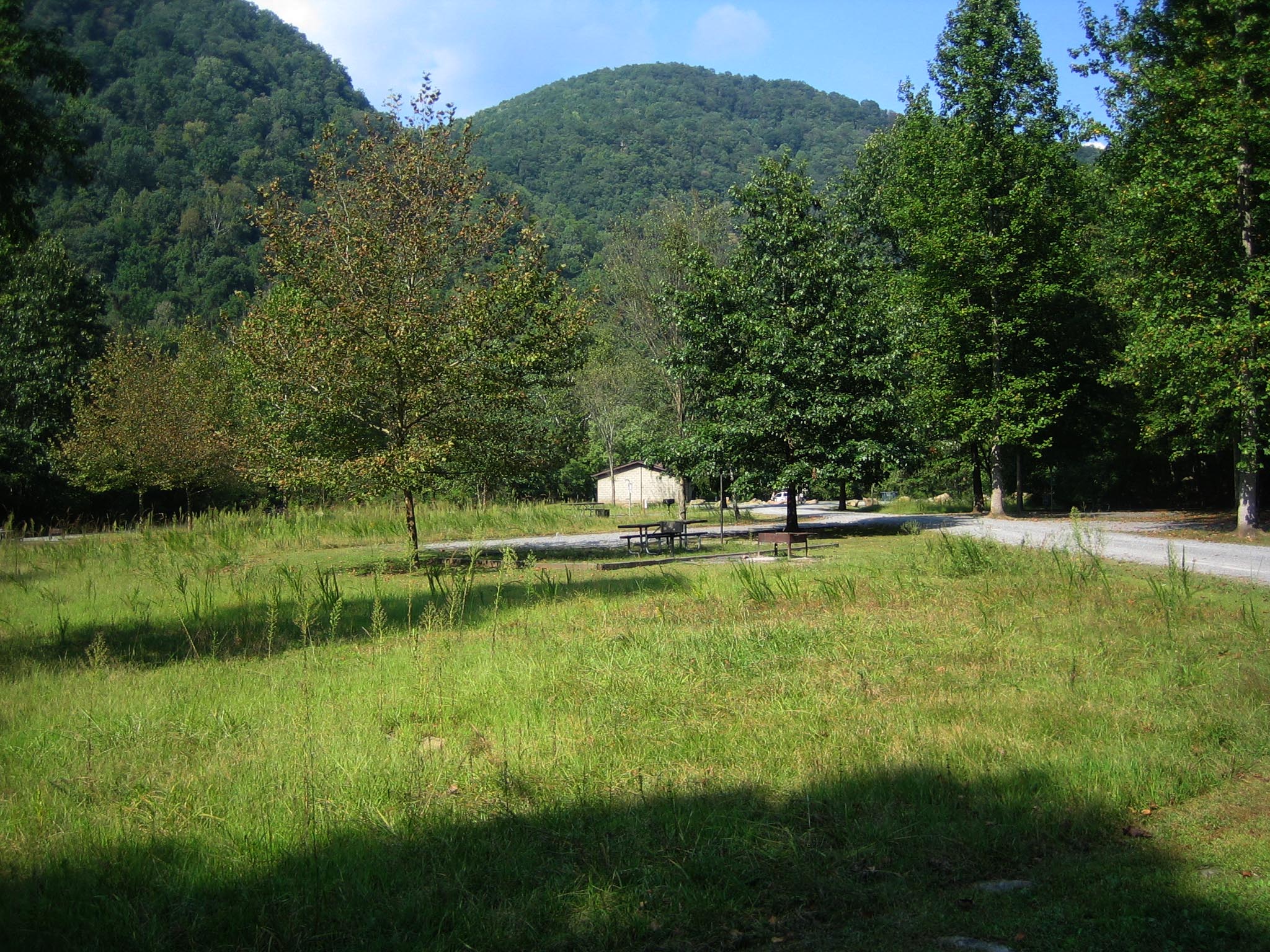
You pull off Route 41 onto an unmarked dirt road, cross the New River, and the pavement ends. That's how you find Army Camp - 11 drive-in sites tucked against one of the New River's horseshoe bends. This isn't a developed campground with a host station and flush toilets. It's a stripped-down riverside camp that fills early and rewards people who come prepared.
NPS via NPS.gov (Public Domain)
Campsites at Army Camp (2026 Guide) — planning tips
5 min read
Campsite Guide
You pull off Route 41 onto an unmarked dirt road, cross the New River, and the pavement ends. Updated for 2026 with 5 Army Camp: army camp campsite guide
Your plans
For more, see Campsites at Grandview Sandbar (2026 Guide).
For more, see Campsites at Stone Cliff (2026 Guide) and Campsites at War Ridge/backus Mountain Campground (2026 Guide).
For more, see New River Gorge National Park Tours: New River Gorge Self Guided and New River Gorge National Park Scenic Drives: New River Gorge Jeep Trails (2026).
For more, see What Is the Climate in New River Gorge and Best of New River Gorge National Park: Best Town Near (2026).
For more, see complete visitor guide, all campgrounds, hiking trails, lodging and accommodations, Campsites at Glade Creek Campground (2026 Guide) (2026 guide), and Campsites at Thayer Campground (2026 Guide).
As of 2026, this remains one of the more straightforward options for getting onto the river with a vehicle. The complete visitor guide covers the broader area, but this article focuses specifically on what you need to know about Army Camp itself - the site layout, vehicle restrictions, and the realities of camping on an unmarked road.
The 11 Sites and What They Offer
Drive-in Sites Only
All 11 spots at Army Camp are drive-in sites designed for RVs, campers, or tents. You park at your site and set up there - there's no walk-in tent loop or separate tent pad area. This keeps things simple, but it also means your neighbors are parking next to you regardless of what you're sleeping in.
Small RVs and campers (under 25 feet) handle this campground best. Medium rigs between 22 and 31.5 feet will fit, but driver skill matters on the dirt access road. Large RVs and campers over 31.5 feet are not recommended. The park service is blunt about this - and for good reason. That unmarked road off Route 41 has tight sections and limited turnaround options.
Shade Situation Varies
Some sites get partial shade. Others sit fully exposed with no cover at all. This matters more than most first-time visitors expect. On a July afternoon with temperatures in the upper 80s, an open site with no shade and a dark RV roof turns into an oven by 4 PM. If you're booking for summer, aim for the sites with partial shade. The exposed spots work better in cooler months when the extra sun is welcome.
Rangers will tell you that shade at Army Camp isn't consistently mapped or marked online. You'll want to arrive early enough to assess the sites in person and pick accordingly. Early morning is your best bet for getting a choice spot.
Strict Designated Site Rule
Camp only at the designated sites. RV, camper, or car camping in non-designated areas is strictly prohibited. The enforcement here isn't aggressive in a confrontational way, but the park service checks. Parking on the road shoulder or pulling off into the brush to set up a tent will get you asked to leave at minimum. There are exactly 11 legal spots. Plan around that number.

Getting There and Getting Settled
The Unmarked Dirt Road
The access road to Army Camp is a dirt road off Route 41 near Prince. Coming from Beckley, it's the first left after you cross the New River. There is no sign marking the turn. You drive past it the first time - almost everyone does. The road itself is unpaved and can get rough after rain. A sedan can handle it in dry conditions, but low-clearance vehicles will scrape in spots after a storm.
Cell service drops out at the turnoff from Route 41. Download your directions before you leave pavement. The GPS coordinates are easy enough to plug in ahead of time, but don't expect to be pulling them up once you're on the dirt road.
What to Bring
There are no services at Army Camp. No water spigots, no electric hookups, no dump station, no bathhouse. You are entirely self-contained. Pack extra water for this stretch - figure a gallon per person per day minimum, plus cooking and cleaning water. If you're in an RV, fill your fresh tank before you leave Beckley or Fayetteville.
The nearest reliable water and supplies are back in Prince or Beckley, about 15-20 minutes depending on road conditions. Make the run before you set up camp, not after.

Who Should Stay Here
Army Camp suits a specific kind of camper: someone who wants to be on the river, doesn't need amenities, and can operate self-contained. It's not the right choice for first-time campers or anyone who needs a bathhouse, a camp store, or reliable shade.
The river access is the draw. From Army Camp you can put in directly on the New River at one of its many horseshoe bends. Fishing, wading, and paddling are the primary activities. The campground sees heavier use during whitewater season - spring runoff and fall releases bring paddlers who want to be steps from the put-in.
Most visitors underestimate how remote this spot feels despite being relatively close to Beckley. The unmarked road, the lack of services, and the quiet (or the sound of the river, depending on water levels) create the sense of being further out than you actually are.
What the Park Website Doesn't Mention
The park's official materials list Army Camp as open year-round, but they don't emphasize that the dirt road becomes less passable in wet weather. A few days of rain turns the access road into a muddy track that can trap two-wheel-drive vehicles. Locals have a saying about it - if you're not sure about the road condition, wait a day.
Also not widely noted: sites here tend to book in the order of arrival. There's no reservation system. You show up, claim an open site, and pay the fee. Arriving after 4 PM on a Friday during summer means you're likely looking at a full campground. Plan to arrive early or have a backup option.

Practical Takeaways
- Arrive early. There are only 11 sites, no reservations, and summer weekends fill by late afternoon.
- Check your vehicle length. Under 25 feet is ideal. Over 31.5 feet is a problem. Take the recommendation seriously - turning around on that dirt road with a big rig is not a good time.
- Bring all your own water. There is none on site.
- Download directions before you leave Route 41. Cell service drops at the turnoff and doesn't come back until you're back on pavement.
- The unmarked road is easy to miss. Coming from Beckley, first left after crossing the New River. Scout it in daylight if possible.
- Partial shade sites exist but aren't marked online. Arrive early enough to choose.
- No reservations. First come, first served. Plan accordingly.
- Wet weather makes the road worse. Have a backup plan if rain is in the forecast.
- For a broader look at camping options in the area, check the guide to all campgrounds in the New River Gorge.

Final Thoughts
Army Camp doesn't try to be anything it's not. Eleven sites on a dirt road at a horseshoe bend on the New River. No frills, no services, no reservations. It works well for people who know what they're doing and have their setup dialed in. It punishes people who show up unprepared. That's the bargain. If you're the type of camper who reads the road conditions, packs enough water, and doesn't need a bathhouse, you'll appreciate what Army Camp offers. If you need hand-holding, pick a developed campground with a host and a store. Either way, know what you're getting into before you turn off Route 41 onto that unmarked road.
Sources
- Official source: NPS — New River Gorge National Park nps.gov/neri/index.htm
Photo Gallery
More to Explore

Park Guide
Acadia National Park: Carriage Roads, Cadillac Mountain & 2026 Guide
Discover carriage roads, Cadillac Mountain, and rugged Maine coast. Complete 2026 guide to Acadia National Park — trails, fees, lodging, permits, and what rangers recommend.

Hiking Guide
Grand Canyon Hiking Trails: Day Hikes, Water Sources & Rim to Rim
Compare Grand Canyon hiking trails: Bright Angel, South Kaibab, Hermit, Grandview, and rim to rim, with distances, elevation, water stops, and trailhead access for each.

Best Of
Best of Glacier Bay National Park
The best of Glacier Bay is reached by boat: ranger-led day tours up the bay to the tidewater glaciers. What's worth it, how to book, and when to go (2026).

Campsite Guide
White Sands Backcountry Camping: Closed for 2026 — What to Know
As of 2026, backcountry camping at White Sands National Park is closed for site rehabilitation. What that means, and where to camp nearby instead.

Weather Guide
Guadalupe Mountains National Park Weather: Weather
Guadalupe Mountains National Park: weather guide guide updated 2026. Practical visitor information, reservations, and seasonal tips worth bookmarking before

Best Of
Best of Cuyahoga Valley National Park: Best Things to Do
Seeing a Cleveland Orchestra concert with the woods as your backdrop is a uniquely Cuyahoga Valley experience.
Sign in to join the conversation.
Sources & Attribution
Location data courtesy of the National Park Service (U.S. Department of the Interior). NPS data is public domain.
Images: NPS; NPS; NPS; NPS; NPS.
Map data © OpenStreetMap contributors.
Park operations alerts: NPS.gov · Weather and weather hazards: National Weather Service · Live conditions.
Information may change. Always verify fees, hours, and conditions directly with the official source before visiting.
Did this guide help? Share it with a friend.