Ditch Creek Pathway Access: Everything You Need to Know - 2026 Guide
NPS via NPS.gov (Public Domain)
Ditch Creek Pathway Access
9 min read
Places & Points of Interest
Discover Ditch Creek Pathway Access: ditch creek pathway access with our comprehensive guide. Expert tips, practical information, and insider knowledge.
Your plans
The Ditch Creek Pathway Access is a modest but essential component of Grand Teton's multi-use pathway system, built to provide cyclists a safer route off the main highway. Situated just south of Antelope Flats Road, it serves as a crucial link for completing the popular Antelope Flats-Kelly loop. This isn't a scenic overlook—it's a functional starting point. Knowing how to use this access allows you to experience the park's eastern sagebrush flats and Mormon Row with fewer vehicles and more solitude.
Overview
Grand Teton's multi-use pathway system was developed in response to years of visitor concerns about cycling alongside highway traffic on US 26/89/191. The Ditch Creek Access marks the northern end of the section running from Moose Junction. From here, cyclists can ride a loop using Antelope Flats Road to Kelly and back via Gros Ventre Junction, avoiding the main highway entirely. This design came from persistent safety planning and public input.
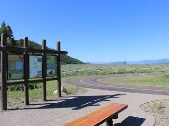
The access point is purely functional: a small gravel lot at the base of Blacktail Butte, just south of Antelope Flats Road. The terrain is flat, open sagebrush, with Blacktail Butte to the west and the Tetons dominating the northwest skyline. Listen for the wind in the sage and the faint highway hum a half-mile off. This is where you transition from vehicle to trail, shifting into the park's quieter rhythm.
Quick Information
- Entrance Fee: Access to the pathway requires a Grand Teton National Park entrance pass. As of 2026, that's $35 per vehicle for a 7-day pass. Cyclists entering without a vehicle pay $20 per person.
- Hours: The pathway and parking area are accessible 24/7, but the park is open year-round. Winter snow will cover the pathway and adjacent roads.
- Best Time to Visit: Late May through early October, when the adjacent Antelope Flats Road is clear of snow and mud.
- Location: Southeast Grand Teton National Park, Wyoming. Nearest major area is Moose Junction, about 4 miles northwest. GPS coordinates are 43.661341, -110.697918.
- Accessibility: The parking area and pathway connection are ADA compliant, with a firm, level surface.
- Cell Service: Spotty to non-existent. Verizon might show one bar; others typically have no signal. Plan to have maps downloaded.
- Restrooms: None at the parking lot. The nearest vault toilets are at the Mormon Row historic district parking area, about a 2-minute drive east on Antelope Flats Road.
- Parking: A small gravel lot fits about 8-10 vehicles. It fills by 9 AM on summer weekends with cyclists and photographers heading to Mormon Row. Overflow parking is not permitted along the road shoulders.

Getting There
From the town of Jackson, head north on US Highway 26/89/191 for approximately 12 miles. You'll pass the Gros Ventre Junction and the turnoff for Kelly. About 4 miles north of Moose Junction, look for Antelope Flats Road turning off to the east (right). The small Ditch Creek Pathway Access parking lot is immediately on the south (right) side of Antelope Flats Road, just a few yards off the highway. There's a small brown NPS sign marking it.
If you're coming from the north (Yellowstone), drive south on US 26/89/191 for about 20 miles from the Jackson Lake Junction. The turn will be on your left just after you pass the Blacktail Butte pullout. The parking situation here is straightforward but limited. Rangers will tell you that if the lot is full, do not park on the vegetation or block the pathway entrance. Your best bet is to drive the short distance to the Mormon Row parking area and start your ride from there, though that adds a short section on Antelope Flats Road.
What to Expect
Expect a functional starting point. The elevation here is about 6,400 feet. The air is dry, and the sun is intense. The parking lot is gravel, often dusty, and offers no shade. From this spot, you're looking at wide-open sagebrush flats stretching east toward the Gros Ventre Mountains, with the iconic Mormon Row barns visible about a mile away. The Teton Range is perfectly framed to the northwest.
The pathway connection is a short, paved ramp that leads you onto the multi-use path heading east, which then curves to meet Antelope Flats Road. The surface is smooth asphalt, about 8 feet wide. The transition from parking lot to pathway is seamless and level, designed for wheelchairs and bicycles alike. The most common sound is the crunch of gravel under bike tires leaving the lot, quickly replaced by the smooth whir of tires on pavement. The smell is pure high-desert sage, especially after a rain.
Most first-time visitors are caught off guard by how exposed and windy it can be. This isn't a forested trailhead. There's no water, no shelter, and no visitor services. You are entirely self-sufficient here. The payoff is immediate access to one of the park's most popular cycling loops and one of its most photographed sunrise locations.

Top Attractions & Points of Interest
The access point is the gateway, not the attraction. But from here, you can efficiently reach several key sites.
Mormon Row Historic District
What makes it special: The iconic Moulton Barns, with the Tetons as a backdrop, are arguably the most photographed structures in the American West. It's a preserved glimpse into early 20th-century homesteading.
How to get there: From the pathway access, it's an easy 1-mile bike ride or drive east on Antelope Flats Road. The parking area for the barns is on the north side of the road.
Best time to visit: Sunrise. The light on the Tetons behind the barns is exceptional. By 8 AM, the area is crowded with photographers and tour groups.
Antelope Flats Road
What makes it special: This gravel road is a scenic, low-traffic alternative to the main highway. It's the core of the recommended bike loop, offering expansive views and frequent wildlife sightings, especially pronghorn and bison.
How to get there: The pathway from the parking lot connects directly to the road.
Best time to visit: Early morning or late afternoon for wildlife activity and softer light.
Blacktail Butte
What makes it special: The prominent butte west of the highway offers a network of hiking trails through forest and meadow, with panoramic views from the top. It's a quieter hiking option.
How to get there: The Blacktail Butte Trailhead is about a mile north on US 26/89/191, not directly accessible from the pathway access without riding on the highway shoulder.
Best time to visit: Summer and fall. The trail can be muddy in spring.
Gros Ventre River Area
What makes it special: A less-visited area of the park with opportunities to see moose, elk, and river scenery. The camping options at Gros Ventre Campground are the park's largest.
How to get there: Continue the bike loop south from Kelly on the Gros Ventre Road.
Best time to visit: Evening for wildlife along the river.
Activities
Bicycling
This is the primary activity for the Ditch Creek Pathway Access. The classic loop is roughly 18 miles: Start at the access, take the pathway east to Antelope Flats Road, head south to the town of Kelly, turn west onto Gros Ventre Road, then north back to Gros Ventre Junction. From there, you can take the multi-use pathway that runs parallel to the highway back to your starting point. The route mixes paved pathway, gravel road (Antelope Flats), and paved secondary road (Gros Ventre). Traffic is light except near the junctions. Pack extra water for this stretch; there are no services on the loop.
Photography
Sunrise at Mormon Row is the premier objective. From the Ditch Creek access, you can drive or bike to the barns quickly to set up before first light. The long, straight line of Antelope Flats Road also creates leading-line photo opportunities with the mountains. Early morning is your best bet for clear skies and calm air.
Wildlife Viewing
The sagebrush flats are prime habitat for pronghorn antelope, bison, and ground squirrels. Coyotes are often seen at dawn and dusk. This is a superb area for wildlife viewing from the relative quiet of a bicycle or your car along Antelope Flats Road. Always maintain a safe distance - bison are common and unpredictable here.
Hiking Connections
While not a major trailhead itself, the access point connects you via bike or car to several trailheads. The Valley Trail system and trails around Taggart and Bradley Lakes are a short drive north at the Taggart Lake Trailhead.

Seasonal Guide
May - June: Antelope Flats Road typically dries out and opens by late May. Wildflowers bloom in the sagebrush. Mornings are cool (30s-40s °F), afternoons can be warm. Crowds begin to build.
July - August: Peak season. Days are warm (70s-80s °F) with frequent afternoon thunderstorms. The parking lot is full by sunrise. Mosquitoes can be fierce near dawn and dusk. Road dust on Antelope Flats can be significant.
September - October: The best time to visit. Crowds thin, temperatures are pleasant, and the fall colors in the cottonwoods along the Gros Ventre River are spectacular. Mornings start frosty.
November - April: The pathway and Antelope Flats Road are closed to wheeled vehicles by snow. The area becomes part of the winter landscape for cross-country skiing and snowshoeing. Access is by foot from the highway only.
Practical Information
A Grand Teton National Park pass is mandatory. The $35 vehicle pass (2026 rate) is the most common. An annual America the Beautiful Pass ($80) covers the fee. No additional permit is needed to use the pathway or park at the access lot.
For lodging and accommodations, the towns of Jackson and Moose are the closest, with camping options available at the nearby Gros Ventre Campground. There are no food, water, or gas services at the site. The nearest convenience store and gas is at the Gros Ventre Junction, about 3 miles south.
The park service recommends checking their official website for any tours and guided experiences that might include cycling or photography in this area.

Safety & Preparation
Weather: Afternoon thunderstorms are a daily summer hazard. Lightning is a serious risk on the exposed flats. Be off the pathway and away from open areas by early afternoon.
Wildlife: This is bison and pronghorn country. Give all wildlife at least 100 feet of space - especially bison. They can run three times faster than you. Do not approach or block their travel path.
Altitude & Sun: At 6,400 feet, hydration is critical. The sun is intense. Use sunscreen, wear a hat, and drink more water than you think you need. There is no shade.
Cycling: Wear a helmet. The pathway is shared with pedestrians. Use a bell or voice to announce your presence. Be prepared for strong crosswinds on the open sections.
Emergency: Cell service drops out at this location. In an emergency, you must flag down a passing motorist on the highway or drive to the nearest ranger station at Moose.
Insider Tips
- The Sunrise Scramble: If the Mormon Row parking lot is full at sunrise (it often is), the Ditch Creek access lot is your best overflow option. It adds a pleasant 10-minute walk or 2-minute bike ride.
- Loop Direction: Most cyclists do the loop clockwise (Antelope Flats first). Doing it counter-clockwise puts the morning sun at your back and often means facing less wind.
- Gravel Road Note: Antelope Flats Road is well-maintained gravel, but it can be washboarded. A road bike with 28mm+ tires can handle it, but a hybrid or gravel bike is more comfortable.
- What the Website Doesn't Mention: The small interpretive panel at the pathway entrance is often overlooked. It explains the purpose of the pathway system and the history of the area - worth a 30-second read.
- Post-Ride Refreshment: After your loop, the drive into Kelly to the Kelly Warm Springs (just off Gros Ventre Road) is a local secret for a chilly, shallow dip on a hot day. It's not an official park site, so visit respectfully.
- Avoid the Midday Heat: This area bakes. Plan your bike loop for early morning. By 11 AM, the sun is direct, the road shimmers with heat, and wildlife retreats to shade.
- Parking Patrol: Rangers do occasionally ticket vehicles parked outside the designated lot or blocking the pathway entrance. The gravel looks inviting to spread out, but don't.
The Ditch Creek Pathway Access won't take your breath away. It's a patch of gravel at the edge of a sagebrush flat. But it represents something important: a deliberate effort to make the park safer and more accessible. It's a starting line for a quieter, two-wheeled perspective of the Tetons, and a strategic basecamp for one of the park's most famous views. Use it for what it is, and you'll appreciate the simple efficiency of the place.
For more information, see our complete Grand Teton National Park Guide.
Sources
- Official source: NPS — Grand Teton National Park nps.gov/grte/index.htm
- Official source: National Park Service nps.gov/places/000/ditch-creek-pathway-access.htm
Photo Gallery
More to Explore

Park Guide
Acadia National Park: Carriage Roads, Cadillac Mountain & 2026 Guide
Discover carriage roads, Cadillac Mountain, and rugged Maine coast. Complete 2026 guide to Acadia National Park — trails, fees, lodging, permits, and what rangers recommend.

Hiking Guide
Grand Canyon Hiking Trails: Day Hikes, Water Sources & Rim to Rim
Compare Grand Canyon hiking trails: Bright Angel, South Kaibab, Hermit, Grandview, and rim to rim, with distances, elevation, water stops, and trailhead access for each.

Best Of
Best of Glacier Bay National Park
The best of Glacier Bay is reached by boat: ranger-led day tours up the bay to the tidewater glaciers. What's worth it, how to book, and when to go (2026).

Campsite Guide
White Sands Backcountry Camping: Closed for 2026 — What to Know
As of 2026, backcountry camping at White Sands National Park is closed for site rehabilitation. What that means, and where to camp nearby instead.

Weather Guide
Guadalupe Mountains National Park Weather: Weather
Guadalupe Mountains National Park: weather guide guide updated 2026. Practical visitor information, reservations, and seasonal tips worth bookmarking before

Best Of
Best of Cuyahoga Valley National Park: Best Things to Do
Seeing a Cleveland Orchestra concert with the woods as your backdrop is a uniquely Cuyahoga Valley experience.
Sign in to join the conversation.
Sources & Attribution
Location data courtesy of the National Park Service (U.S. Department of the Interior). NPS data is public domain. Official NPS page.
Images: NPS; NPS; NPS; NPS; NPS.
Map data © OpenStreetMap contributors.
Park operations alerts: NPS.gov · Weather and weather hazards: National Weather Service · Live conditions.
Information may change. Always verify fees, hours, and conditions directly with the official source before visiting.
Did this guide help? Share it with a friend.