Grand Teton National Park Hiking: Jenny Lake, Cascade Canyon & Teton Crest Trails (2026 Guide)
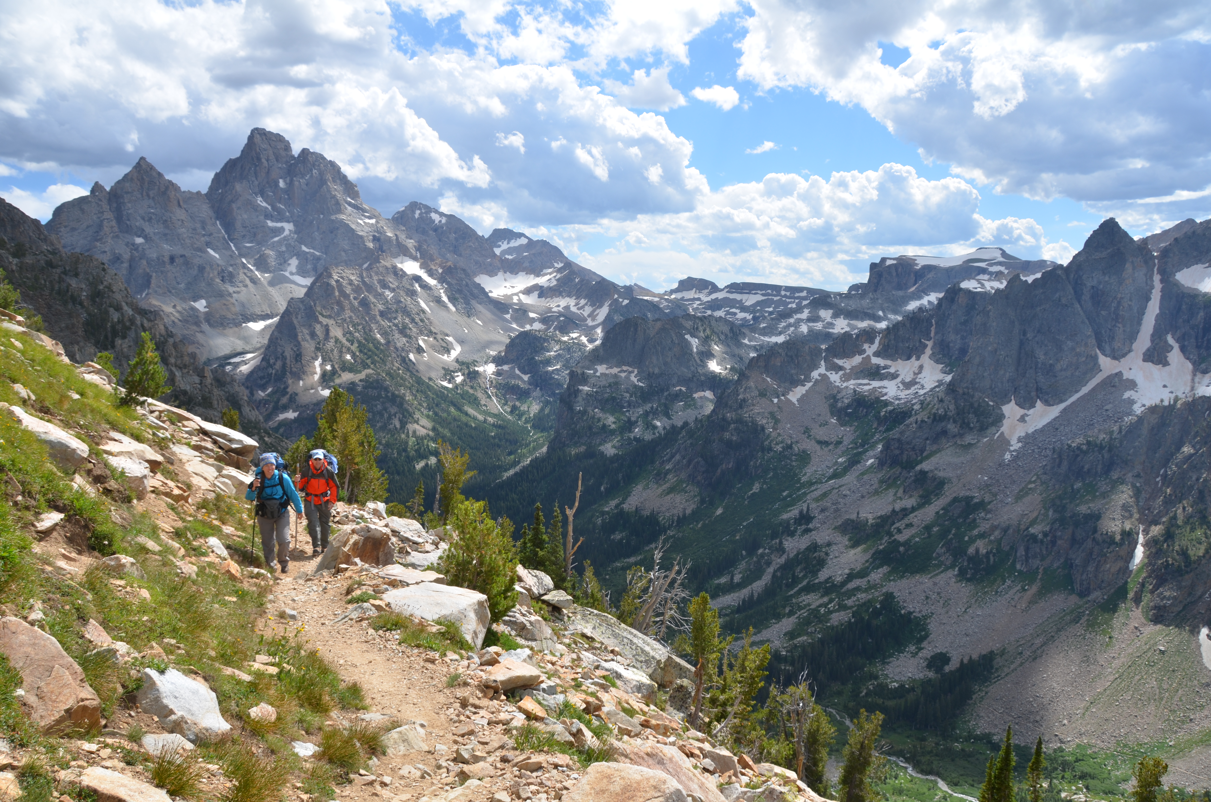
NPS via NPS.gov (Public Domain)
Hiking Grand Teton National Park
11 min read
Hiking Guide
Complete 2026 hiking guide for Grand Teton National Park. Trails, difficulty ratings, seasonal conditions, and practical tips for every skill level.
This article contains affiliate links — we may earn a small commission at no extra cost to you.
Hiking here means vertical. The Tetons rise abruptly from the valley floor, and the trails follow suit. You're not meandering through foothills; you're gaining elevation from the first step. This isn't a park for casual strolls unless you stay on the valley floor. Most of the best Teton trails demand strong legs, good lungs, and a tolerance for switchbacks that seem endless. First-time visitors consistently underestimate the altitude—the valley sits around 6,800 feet—and the physical commitment required to reach the alpine zones. Hiking Grand Teton is about earning your views, one steep, rocky mile at a time.
The Signature Loop: Paintbrush Canyon - Cascade Canyon
The definitive Teton hike. A 20-mile loop that climbs over a 10,700-foot pass, passes an iconic alpine lake, and descends through the park's most famous canyon. It's a full-day commitment that encapsulates everything the range has to offer.
Distance: 20 miles
Elevation Gain: Approximately 4,300 feet
Trailhead & Parking: Start at either the String Lake or Leigh Lake trailhead. The String Lake lot is smaller and fills by 7:30 AM on a summer morning. Leigh Lake has more space but adds a flat mile to the loop. Rangers will tell you to have a backup plan if you arrive after 8 AM.
The Trail: The standard route goes counter-clockwise, ascending Paintbrush Canyon. The trail narrows here, climbing steadily through forest before opening into meadows with increasing views back toward Jackson Lake. The final push to Paintbrush Divide is steep, often holding snowfields into late July. The descent into the North Fork of Cascade Canyon is rocky and exposed. From Lake Solitude, it's a long, gradual downhill through widening meadows in Cascade Canyon, eventually merging with the main trail above Jenny Lake.
The Moment: Cresting Paintbrush Divide. The world drops away on both sides, revealing the sheer scale of the range you're traversing. To the north, the jagged peaks of the Cathedral Group; to the south, the long green trench of Cascade Canyon.
What Most Underestimate: The weather on the Divide. It's a notorious wind tunnel and attracts afternoon thunderstorms like a magnet. Most parties take 10-14 hours. Starting at dawn isn't just advice; it's a safety requirement.
Best Time: Late July through mid-September, once the high snow has melted. Early August for wildflowers.
Cascade Canyon (to Lake Solitude)
This is the most popular high canyon hike for good reason. It provides a relatively moderate grade by Teton standards, paired with continuous, staggering scenery.
Distance: 14 miles round-trip from Jenny Lake trailhead
Elevation Gain: About 2,300 feet
Trailhead & Parking: The Jenny Lake trailhead is a zoo. It's often full by 8 AM. The smarter move is to take the shuttle boat across Jenny Lake (runs 7 AM-7 PM in summer, fee applies) from the south shore, which cuts off 2 miles each way. The boat dock on the west shore is your trailhead.
The Trail: From Inspiration Point, it's a steady, well-graded climb up the canyon floor. The trail follows Cascade Creek, passing through forests and expansive meadows with non-stop views of the Grand, Middle, and South Tetons looming directly ahead. The trail offers a series of iconic, picture-perfect views. The final climb to Lake Solitude is steeper, switchbacking up a headwall.
The Moment: The first time the canyon walls open into the large meadow known as the "Forks," where the North and South Fork converge. The view up-canyon to the Grand Teton is unobstructed and immense.
What Most Underestimate: The crowds. This is the park's hiking superhighway. You won't have solitude until well past the Forks. Pack extra water for this stretch; the creek is often far below the trail.
Best Time: July through September. Early morning to avoid the human traffic jam and for the best light on the peaks.
Jenny Lake Loop
The classic introductory hike. It's mostly flat, circles the park's most famous lake, and provides access points to longer trails.
Distance: 7.5 miles
Elevation Gain: Minimal
Trailhead & Parking: Use the large Jenny Lake Visitor Center lot. It fills, but turnover is constant. If full, the String Lake lot is a 10-minute walk south via a connecting path.
The Trail: A wide, well-maintained path that hugs the shoreline. The west side is more rugged and scenic, with closer views of the canyon mouths and peaks. The east side is more developed, passing near the visitor center. You can hike it in either direction.
The Moment: The view from the west shore looking back across the lake's blue water to Teewinot Mountain and Mount St. John. Early morning is your best bet for glassy water reflections.
What Most Underestimate: The distance. Seven and a half miles of flat walking is still a half-day commitment. The sun exposure on the east shore can be intense. Many combine it with the short spur up to Hidden Falls and Inspiration Point.
Best Time: Any day the trail is snow-free, from late May to October. Sunrise or sunset for photography.

Taggart Lake
An excellent, manageable hike with a big payoff. It's the go-to recommendation from rangers for visitors with limited time or fitness.
Distance: 3.3 miles round-trip
Elevation Gain: 350 feet
Trailhead & Parking: The Taggart Lake Trailhead is right off Teton Park Road. Its lot is smaller than Jenny Lake's but also fills by 9 AM on summer days. Overflow parking extends along the road shoulder.
The Trail: A straightforward climb through a burn area from the 1985 Beaver Creek fire, offering open views of the peaks. The trail then enters recovering forest before reaching the lake's gravelly shore. The view of the Grand Teton reflected in the lake is the prize.
The Moment: Rounding the final bend to see the lake and the full frontal view of the Cathedral Group. It feels earned despite the short hike.
What Most Underestimate: The mosquito population in the wooded sections near the lake, especially in June and July. Bring repellent.
Best Time: Late spring through fall. It's often hikeable by mid-May when higher trails are still snowbound.
Surprise and Amphitheater Lakes
A brutal, relentless climb to two alpine lakes tucked under the sheer east face of the Grand Teton. This is not a casual hike.
Distance: 10.2 miles round-trip
Elevation Gain: 3,000 feet
Trailhead & Parking: Starts at the Lupine Meadows trailhead, the launch point for Grand Teton climbers. This lot fills by 6 AM in peak season. Arrive late, and you're adding a mile of road walking.
The Trail: Unrelenting switchbacks through forest for the first two miles. The trail then breaks out onto open slopes with incredible, expanding views of the valley. The final push to Surprise Lake is across talus and lingering snowfields. Amphitheater Lake sits a few hundred feet higher in a stark, rocky cirque.
The Moment: Gazing up from the shore of Amphitheater Lake at the 3,000-foot vertical wall of Disappointment Peak and the Grand. The scale is almost incomprehensible.
What Most Underestimate: The elevation gain per mile. It's one of the steepest sustained climbs in the park. The altitude at the lakes (nearly 10,000 feet) hits hard. This is an all-day effort for fit hikers.
Best Time: August and September. The high basin holds snow well into July.
Death Canyon to Static Peak Divide
A quieter, more rugged alternative to the Cascade Canyon area. It leads to a high, windy divide with panoramic views into Idaho.
Distance: 16 miles round-trip
Elevation Gain: 5,000 feet
Trailhead & Parking: Death Canyon Trailhead, accessed via a rough dirt road off Moose-Wilson Road. The small lot fills early. High-clearance vehicles are helpful but not mandatory if driven carefully.
The Trail: A steep climb to the Phelps Lake Overlook, then a descent into Death Canyon proper. The trail follows the canyon floor before launching into a grueling, switchbacking ascent up the side of Static Peak. The final ridge walk to the divide is exposed and spectacular.
The Moment: At the Divide, looking west into the vast, roadless expanse of the Jedediah Smith Wilderness. You feel like you're on the edge of the world.
What Most Underestimate: The total elevation gain. Five thousand feet is a massive day, especially at altitude. This is often done as an overnight backpacking trip. Water is scarce on the upper slopes.
Best Time: Late July to September. Prone to afternoon thunderstorms on the exposed divide.

String Lake Loop
A family-friendly, scenic stroll that feels far removed from the Jenny Lake crowds just to the south.
Distance: 3.7 miles
Elevation Gain: Minimal
Trailhead & Parking: The String Lake lot. It fills quickly because it serves this trail, the Leigh Lake trail, and overflow for Jenny Lake. Aim to be there by 8:30 AM.
The Trail: A flat, sandy path that circles the long, narrow lake. The water is shallow and famously warm (for the Tetons), making it popular for wading and swimming in late summer. The views of Rockchuck Peak and Mount St. John are constant.
The Moment: The view from the north end of the lake, looking down its entire length toward the Cathedral Group. The elevation gain is worth it for this perspective alone.
What Most Underestimate: The swimming potential. On a hot August afternoon, the lake's east shore is dotted with people cooling off. Bring water shoes; the bottom is rocky.
Best Time: Summer and early fall. The water is warmest in August.
Hermitage Point
A long, flat hike through forests and along the shores of Jackson Lake, offering a different, quieter side of the park.
Distance: 9.7 miles
Elevation Gain: 300 feet
Trailhead & Parking: Colter Bay Visitor Center. Plenty of parking, but it's a busy hub for boaters and campers. Cell service drops out at the point.
The Trail: A network of trails leads through forests and past small ponds (Heron Pond, Swan Lake) before reaching the long, wooded peninsula of Hermitage Point. The final approach opens to rocky beaches and broad views of the lake and the northern Teton Range.
The Moment: Reaching the tip of Hermitage Point. It's a wide, open area with 270-degree views of the lake, with the Tetons rising in the distance. It feels remote, despite starting at a major hub.
What Most Underestimate: The potential for wildlife. This is prime moose and bear habitat around the ponds. Carry bear spray and know how to use it. The trail can be muddy in spring.
Best Time: Late spring through fall. A good option when the high country is socked in with weather.
Seasonal Trail Conditions
Your hike is dictated by the calendar. Snow dictates everything.
June: A transitional month. Valley trails (Taggart, Jenny Lake Loop, String Lake) are usually clear by early June. Mid-elevation trails like Cascade Canyon may have significant snow patches and high water crossings. Paintbrush Divide and Static Peak Divide are almost always snow-covered and require ice axes and experience for safe passage. Mosquitoes hatch in force by late June.
July: The high country begins to open. Lower Cascade Canyon is usually clear by early July, but Lake Solitude and the Divide trails often hold snowfields until late July. Afternoon thunderstorms become a daily occurrence - be off high, exposed ridges by 1 PM. Wildflowers peak in mid-to-late July in the alpine meadows.
August: Prime hiking season. Most high trails are snow-free (though check on Paintbrush Divide). Days are warm, nights are cool. Thunderstorms remain frequent. This is the busiest month on all trails.
September: The best month for hiking Grand Teton National Park, if you're prepared for cold. Crowds thin dramatically after Labor Day. Days are crisp and clear, with a high chance of stable weather. Nights dip below freezing. Fall colors (aspens, willows) peak in mid-to-late September. Snow can fall at any time, especially at higher elevations.
October to May: Most trails are under snow. Winter hiking and skiing are possible on valley trails like Taggart Lake or the Jenny Lake road (closed to cars), but you're in full winter conditions. Check the park's winter access page for current info.

Trailhead Logistics
The parking situation here is a strategic challenge.
Jenny Lake/ String Lake/ Lupine Meadows Corridor: This is ground zero. All lots are full by 8 AM, often earlier. Strategy: Arrive by 7 AM, or plan to use the Jenny Lake shuttle boat to access the west shore trails. Overflow parking spills onto road shoulders, but rangers will ticket you if you block traffic or vegetation.
Moose-Wilson Road Trailheads (Death Canyon, Granite Canyon): Accessed via a narrow, winding road. Parking is very limited. Arrive early or have a backup plan. The road can be rough.
Colter Bay Area: Parking is more plentiful, but it's a long drive from the central park highlights. Good for Hermitage Point, Two Ocean Lake, and Emma Matilda Lake hikes.
Shuttles: The park operates a free hiker shuttle that connects the Visitor Center, Jenny Lake, String Lake, and Taggart Lake trailheads. It runs from 7 AM to 7 PM in summer. Use it. It's the easiest way to avoid the parking headache for loop hikes.
Bear Canisters: Required for all overnight backcountry camping. They can be rented at the Craig Thomas Discovery and Recreation Center in Moose or the Colter Bay Visitor Center. Day hikers don't need them, but you must store all food and scented items in a hard-sided vehicle at the trailhead.
Water: Treat all water from streams and lakes. Giardia is present. Many of the longer, higher trails have long dry sections - carry capacity for 2-3 liters per person.
What to Carry
This isn't a generic list. This is what the Tetons demand.
Footwear: Sturdy hiking boots with ankle support. The trails are rocky, root-strewn, and often steep. Trail runners are insufficient for most people on anything beyond the flat lake loops.
Layers: The weather changes in minutes. A moisture-wicking base layer, an insulating mid-layer (fleece or puffy), and a waterproof, windproof shell are non-negotiable, even on a sunny morning. A warm hat and gloves can save your day on a high pass.
Bear Spray: Carry it in a holster on your hip, not buried in your pack. Every member of your group should know how to deploy it. It's your first line of defense.
Navigation: A physical map and compass, and the knowledge to use them. Cell service is non-existent on trails. GPS devices work, but batteries fail.
Sun Protection: High-altitude sun is intense. Wide-brimmed hat, sunglasses, and SPF 30+ sunscreen are daily necessities.
Illumination: A headlamp with fresh batteries. Even on a day hike, delays happen.
The Extra Quart of Water: Most people under-hydrate at altitude. Plan for one liter for every two hours of hiking, minimum. There are no water fill stations on trail.
Practical Takeaways
- Altitude is your first adversary. Acclimate for a day with short valley hikes before attempting anything above 9,000 feet.
- The parking lot is part of the hike. Plan to arrive at your trailhead by 7:30 AM at the absolute latest in July and August.
- Afternoon thunderstorms are a daily summer certainty. Be below tree line and off exposed ridges by 1 PM.
- Bear spray is not optional equipment. It's as essential as your boots. Rent or buy it before you enter the park.
- "Moderate" in Grand Teton terms means "strenuous" in most other parks. Read elevation gain, not just distance.
- The free park shuttle is the smartest way to link hikes and avoid parking nightmares, especially for the Jenny Lake area.
- Check current trail conditions at the Craig Thomas Discovery Center in Moose. Rangers post updates on snow, bear activity, and closures daily.
- For the best weather and fewer people, target the window between September 10th and October 1st.
- Always have a backup hike in mind. Weather, parking, or trail closures can scuttle your primary plan.
- Your grand teton hiking guide is incomplete without a study of the complete visitor guide for park-wide context, and if you're staying over, research the camping options well in advance. For planning your trip dates, the best time to visit is dictated by snowpack and temperature.
Recommended Gear
What experienced visitors bring to Hiking Grand Teton National Park
Links may earn us a commission at no extra cost to you. We only recommend gear we believe in.
Hiking Essentials
Hydration Pack (3L)
Hands-free water for long trail days
Trekking Poles (Pair)
Save your knees on steep descents
Hiking Boots (Ankle Support)
Sturdy footwear for rocky, uneven trails
Sun & Heat Protection
Wide-Brim Sun Hat
Full coverage UPF 50+ protection at altitude
Insulated Water Bottle (32oz)
Keeps water cold in desert heat all day
Winter Gear
Microspikes / Traction Devices
Essential for icy rim trails in winter months
Packable Down Jacket
Lightweight warmth that stuffs into a pocket
Sources
- Official source: National Park Service nps.gov/grte/planyourvisit/winter.htm
- Official source: NPS — Grand Teton National Park nps.gov/grte/index.htm
Photo Gallery
More to Explore

Park Guide
Acadia National Park: Carriage Roads, Cadillac Mountain & 2026 Guide
Discover carriage roads, Cadillac Mountain, and rugged Maine coast. Complete 2026 guide to Acadia National Park — trails, fees, lodging, permits, and what rangers recommend.

Hiking Guide
Grand Canyon Hiking Trails: Day Hikes, Water Sources & Rim to Rim
Compare Grand Canyon hiking trails: Bright Angel, South Kaibab, Hermit, Grandview, and rim to rim, with distances, elevation, water stops, and trailhead access for each.

Best Of
Best of Glacier Bay National Park
The best of Glacier Bay is reached by boat: ranger-led day tours up the bay to the tidewater glaciers. What's worth it, how to book, and when to go (2026).

Campsite Guide
White Sands Backcountry Camping: Closed for 2026 — What to Know
As of 2026, backcountry camping at White Sands National Park is closed for site rehabilitation. What that means, and where to camp nearby instead.

Weather Guide
Guadalupe Mountains National Park Weather: Weather
Guadalupe Mountains National Park: weather guide guide updated 2026. Practical visitor information, reservations, and seasonal tips worth bookmarking before

Best Of
Best of Cuyahoga Valley National Park: Best Things to Do
Seeing a Cleveland Orchestra concert with the woods as your backdrop is a uniquely Cuyahoga Valley experience.
Sign in to join the conversation.
Sources & Attribution
Location data courtesy of the National Park Service (U.S. Department of the Interior). NPS data is public domain. Official NPS page.
Images: NPS; NPS; NPS; NPS; NPS.
Map data © OpenStreetMap contributors.
Park operations alerts: NPS.gov · Weather and weather hazards: National Weather Service · Live conditions.
Information may change. Always verify fees, hours, and conditions directly with the official source before visiting.
Did this guide help? Share it with a friend.