For more, see hiking trails, camping options, lodging and accommodations, and best time to visit.
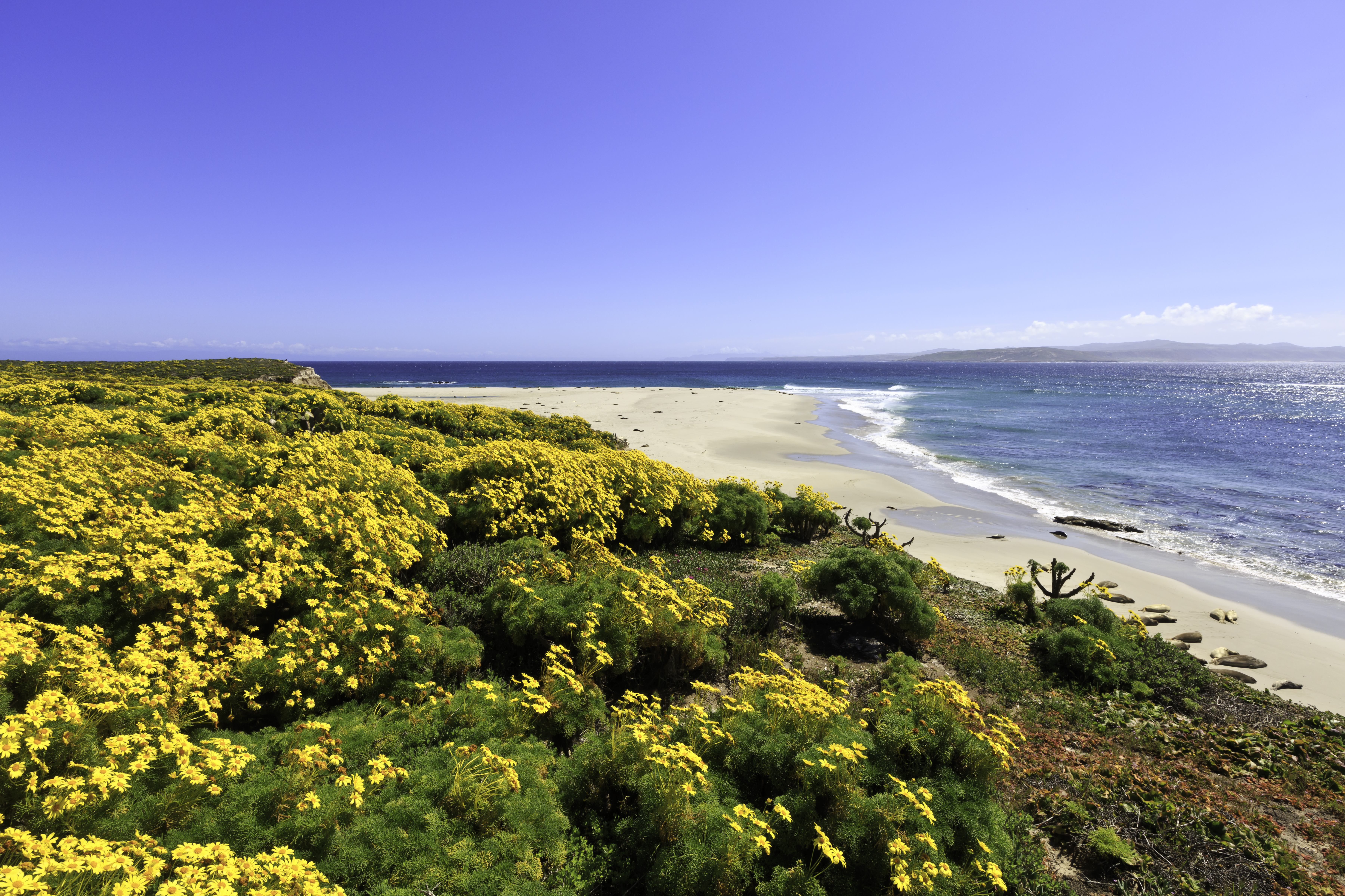
NPS via NPS.gov (Public Domain)
Cardwell Point Hike: Your Complete 2026 Guide to Planning the Perfect Visit
10 min read
Places & Points of Interest
Plan your 2026 visit to Cardwell Point Hike. Complete guide to trails, fees, lodging, best time to visit, and insider tips.
Your plans
A 6-mile hike requiring a ranger escort signals something special. Cardwell Point isn't your typical trail; it's a controlled, strenuous trek across Santa Rosa Island to a coastal vantage point above a seal and sea lion rookery. Access is strictly managed because of historic unexploded ordnance. For visitors who secure a spot, the reward is raw coastal views and wildlife encounters seen by very few. Here's how to plan for it.
Overview
The Cardwell Point route is a 6-mile round trip from Cuyler Harbor on Santa Rosa Island. We classify it as strenuous for good reason. You'll traverse sandy washes, coastal bluffs, and rugged terrain to reach a windswept point overlooking a marine mammal rookery. From there, you can observe California sea lions and harbor seals hauled out on the rocks, their calls carried by the ocean wind.
What the park website emphasizes, and you should take literally, is the mandatory ranger accompaniment. Due to historic unexploded ordnance in the area, entering the zone around Cardwell Point without a ranger is prohibited. This isn't a suggestion; it's a non-negotiable safety rule. The hike exists as a ranger-led program, not a standalone trail. Your planning starts and ends with securing a spot on one of these guided hikes, which are offered seasonally and fill quickly. The experience is less about solitary exploration and more about a curated, educational foray into a protected part of the island.
Quick Information
Before you dream about the views, understand the logistics. This hike operates under specific constraints.
* Access & Fee: There is no separate fee for the Cardwell Point hike itself, but you must pay for the park concessionaire ferry to Santa Rosa Island and secure a spot on the ranger-led hike. Ferry fares as of 2026 start around $80-$120 per person round-trip, depending on the departure point. The ranger program is typically free but requires advance reservation.
* Hours: Access is limited to the scheduled ranger-led hike times, which vary by season. The island is only accessible via ferry, with same-day round-trip schedules that usually require a full day commitment.
* Best Time to Visit: Late spring (May-June) and early fall (September-October) offer the most stable weather and calmer ocean crossings. Summer can be foggy and windy.
* Location: Santa Rosa Island, Channel Islands National Park, California. The nearest mainland departure points are Ventura and Oxnard.
* Accessibility: This trail is not accessible for wheelchairs or strollers. The terrain is uneven, sandy, and includes elevation changes.
* Cell Service: Assume you will have none for the entire duration on the island.
* Restrooms: Vault toilets are available at the landing area at Becher's Bay (the main ferry landing for Santa Rosa). There are no facilities along the hike route to Cardwell Point.
* Parking: Paid parking is available at the Island Packers ferry terminals in Ventura and Oxnard. Lots can fill on summer weekends; arrive at least 45 minutes before your scheduled departure.

Getting There
There's no road access to this trailhead. Reaching the start involves two stages: a ferry crossing, followed by an island shuttle or additional hike.
Start at the Island Packers terminal in Ventura or Oxnard. The crossing to Santa Rosa Island takes 2.5 to 3 hours. Seas are often rough; take motion sickness medication beforehand if needed. The ferry usually lands at the pier in Becher's Bay, which is not Cuyler Harbor. This is the first point of confusion for many.
From Becher's Bay, the ranger-led hike to Cardwell Point usually begins. The group will either hike the several miles to the Cuyler Harbor area or utilize a park vehicle, depending on the specific program logistics that day. You need to confirm the exact meeting point and transportation method when you reserve your hike spot. There is no public transportation on the island. Missing the ranger at the appointed time and place means missing the hike entirely - there are no second chances.
What to Expect
Expect a sense of earned isolation. After the ferry crowd disperses, your small group will set off with a ranger. The trail narrows here, leaving the maintained road for a path of soft, pale sand and crushed shell. Your boots will sink slightly with each step, adding to the workout. The smell is pure coastal California: salt air, dry grass, and the faint, sweet scent of coreopsis in bloom during the spring.
The terrain rolls with the island's topography. You'll climb up onto bluffs of crumbling sandstone, the path a thin tan line through low-growing, wind-sculpted shrubs. From these vantage points, the Pacific stretches to a sharp horizon, a deep blue meeting a paler sky. The sound is constant wind and distant surf. You might spot an island fox darting through the brush - a small, gray-brown blur that's endemic to these islands.
The ranger will stop periodically, pointing out a patch of endemic morning glories or explaining the island's ranching and military history. The mood is focused and educational. As you approach the restricted zone near Cardwell Point, the ranger's guidance becomes more direct, ensuring the group stays on the exact, safe path. The final approach brings the rookery into view and earshot. The barks and groans of hundreds of sea lions create a low, chaotic symphony. The view is a sweeping panorama of Santa Rosa's coastline, with the animals dotting the rocky shore far below. You'll have time to take it in, but you won't be wandering off for a solo photo. The ranger ensures the group stays together, observes quietly, and then returns the way they came.

Top Attractions & Points of Interest
While the main event is the hike itself, the context of Santa Rosa Island adds depth to your visit.
The Marine Mammal Rookery
This is the destination. From the cliffs at Cardwell Point, you look down on a rocky haul-out site used by California sea lions and harbor seals. The ranger will help you distinguish between the two: sea lions are louder, larger, and more social, often piled on top of each other; harbor seals are smaller, quieter, and tend to lounge solo. Bring binoculars. The viewing is distant to avoid disturbance, but quality optics bring the scene to life.
Cuyler Harbor Beach
The general area where the hike often begins or passes near. It's a wide, crescent-shaped beach of fine white sand. If your hike schedule allows time before or after, it's a place to rest, eat a snack, and wade in the cold water. The contrast between the serene beach and the strenuous hike is stark.
The Island Fox
Keep an eye out for this fearless, cat-sized predator. It's the island's apex mammal and a conservation success story. They show little fear of humans and may curiously approach your group from a safe distance. Rangers ask that you never feed them.
Historic Ranching Remains
As you hike, you'll pass weathered fences, old water troughs, and the foundations of buildings from the island's century-long ranching era. The ranger will contextualize these remnants, explaining how the landscape you're walking through was once used for cattle and sheep.
Coastal Bluff Ecology
The hike is a lesson in adaptation. You'll see plants like giant coreopsis, which looks like a small, shaggy tree, and silver lupine, all evolved to survive relentless wind and minimal fresh water. The ranger will point out how these plants support the island's unique insect and bird life.
Activities
The primary activity is the ranger-led hike itself. This is a structured, interpretive experience focused on natural history, wildlife, and safety. It is the only way to legally access Cardwell Point.
Beyond that specific program, Santa Rosa Island offers other hiking trails like the easier Becher's Bay Coastal Trail or the more challenging trek to Black Mountain. You can learn more about the island's network of paths on our dedicated hiking trails page.
Wildlife viewing is exceptional everywhere on the island, from seabirds like the endangered snowy plover to the ever-present fox. For a deeper what you might see, including seasonal whale migrations, check our guide to wildlife viewing.
Kayaking is possible in the protected waters of Becher's Bay, but you must bring your own gear on the ferry. The waters around Cardwell Point itself are not for kayaking due to the rookery and potential hazards.

Seasonal Guide
Your experience is dictated by the season, both for weather and program availability.
Spring (April-June): The best balance. Wildflowers are in bloom, temperatures are mild (60s-70s °F), and winds can be moderate. This is a prime window for the Cardwell Point hike, and ranger programs are most frequent. The ocean crossing is still cool.
Summer (July-September): The most popular and most challenging time. Morning fog ("June Gloom" often lasts through July) can obscure views. Northwest winds pick up in the afternoon, making the hike back feel like a battle. Temperatures are pleasant (70s-80s °F) but the sun is intense. Ferry space and hike reservations are most competitive. For a detailed breakdown of annual patterns, see our best time to visit analysis.
Fall (October-November): Another excellent choice. The winds often diminish, the air is clear, and the water is still warm enough for wading. Ranger-led programs begin to scale back as winter approaches, so check schedules carefully.
Winter (December-March): The Cardwell Point hike is typically not offered. Ferry schedules are reduced, weather is unpredictable with higher chances of rain and strong winds, and the ocean crossing can be rough. The island is quiet, but this is not the season for this particular adventure.
Practical Information
Permits & Reservations: You need two reservations: one for the ferry with Island Packers, and one for the ranger-led Cardwell Point hike. The hike reservation is made through the National Park Service, often via Recreation.gov. Book both as far in advance as possible - months, not weeks.
Camping: If you want to extend your stay, camping options are available on Santa Rosa Island. The Santa Rosa Island Campground (15 sites, $15/night as of 2026) is near Becher's Bay and requires a 1.5-mile hike from the pier with all your gear. There is also Santa Rosa Island Backcountry Beach Camping in designated areas and seasons. All sites are primitive (pit toilets, no water, food storage boxes) and require reservations.
Lodging: There are no hotels or rentals on the islands. All overnight stays are camping. For lodging and accommodations before or after your trip, you'll need to look in Ventura, Oxnard, or Santa Barbara.
Food & Water: There are no stores, restaurants, or drinking water sources on Santa Rosa Island. You must pack in all the food and water you will need for the entire day, plus extra. A minimum of 2-3 liters of water per person for the hike is standard advice.
Tours: For those who prefer structure, concessionaires offer tours and guided experiences like kayaking, snorkeling, and multi-island trips, though these typically do not include the Cardwell Point hike.

Safety & Preparation
This environment demands respect. Preparation is non-negotiable.
The Ocean Crossing: The ferry ride can be extremely rough. Take motion sickness medication 30-60 minutes before boarding if you have any susceptibility. Stay hydrated.
Weather & Exposure: The island has no shade. The sun reflects off the pale sand and water. Wear a wide-brimmed hat, sunglasses, and apply (and reapply) high-SPF sunscreen. The wind can be biting, even on a sunny day; a windbreaker or light shell is essential.
Hydration & Nutrition: Pack more water than you think you need. Dehydration happens quickly in the wind and sun. Bring high-energy snacks like nuts, jerky, and energy bars. You will burn calories on the sandy trail.
Terrain & Footing: The sandy sections are tiring. The rocky, uneven sections require attention to avoid turning an ankle. Wear sturdy, broken-in hiking boots with good ankle support. Trekking poles are highly recommended for stability, especially on the return trip when you're fatigued.
Wildlife Safety: Maintain a respectful distance from all wildlife. This is for their protection and yours. The island foxes are curious but wild; do not attempt to touch or feed them. Give marine mammals on the beach a wide berth.
Emergency: There is no cell service. Your ranger is your point of contact for any emergency. They carry a radio to contact the island's mainland support. Know your limits and communicate any issues to the ranger early.
Insider Tips
- Book the Hike First: Before you book your ferry ticket, confirm there is space on the Cardwell Point hike for your desired date. Then immediately book your ferry passage. The hike reservation is the limiting factor.
- The Morning Boat is Mandatory: Ranger-led hikes almost always require you to be on the first ferry of the day to the island. Afternoon or mid-day arrivals will not work for this program.
- Pack for Two Climates: Dress in layers. Start with a moisture-wicking base layer, add insulation, and top it with a windproof/waterproof shell. The microclimate on the island can change from calm and warm to windy and cold in minutes.
- Break in Your Boots on Sand: If possible, train for this hike by walking on a beach or sandy path. The specific muscle fatigue from soft sand is what catches most hikers off guard.
- Bring a Zip-top Bag for Your Phone: The fine, powdery sand gets into everything. Keep your phone and camera in a sealed bag when not in use.
- Listen to the Ranger's Pace: They set the speed for a reason - to ensure the group stays together and manages energy over the 6-mile distance. Don't rush ahead.
- The Gift Shop Sells Water, But... The visitor center in Ventura sells water bottles. But at national park prices. Save money and reduce waste by filling your own reusable bottles at home or at the free water stations at the ferry terminal.
The Cardwell Point hike is a commitment. It requires planning, physical effort, and a willingness to follow rules. For those who make the effort, the reward is an authentic, ranger-guided immersion into a wild corner of the California coast that very few people ever witness directly. It's not a casual stroll. It's an expedition. Plan accordingly.
For more information, see our complete Channel Islands National Park Guide.
Sources
- Official source: NPS — Channel Islands National Park nps.gov/chis/index.htm
- Official source: National Park Service nps.gov/places/cardwell-point-hike.htm
Photo Gallery
More to Explore

Park Guide
Acadia National Park: Carriage Roads, Cadillac Mountain & 2026 Guide
Discover carriage roads, Cadillac Mountain, and rugged Maine coast. Complete 2026 guide to Acadia National Park — trails, fees, lodging, permits, and what rangers recommend.

Hiking Guide
Grand Canyon Hiking Trails: Day Hikes, Water Sources & Rim to Rim
Compare Grand Canyon hiking trails: Bright Angel, South Kaibab, Hermit, Grandview, and rim to rim, with distances, elevation, water stops, and trailhead access for each.

Best Of
Best of Glacier Bay National Park
The best of Glacier Bay is reached by boat: ranger-led day tours up the bay to the tidewater glaciers. What's worth it, how to book, and when to go (2026).

Campsite Guide
White Sands Backcountry Camping: Closed for 2026 — What to Know
As of 2026, backcountry camping at White Sands National Park is closed for site rehabilitation. What that means, and where to camp nearby instead.

Weather Guide
Guadalupe Mountains National Park Weather: Weather
Guadalupe Mountains National Park: weather guide guide updated 2026. Practical visitor information, reservations, and seasonal tips worth bookmarking before

Best Of
Best of Cuyahoga Valley National Park: Best Things to Do
Seeing a Cleveland Orchestra concert with the woods as your backdrop is a uniquely Cuyahoga Valley experience.
Sign in to join the conversation.
Sources & Attribution
Location data courtesy of the National Park Service (U.S. Department of the Interior). NPS data is public domain. Official NPS page.
Images: NPS; NPS; NPS; NPS; NPS.
Map data © OpenStreetMap contributors.
Park operations alerts: NPS.gov · Weather and weather hazards: National Weather Service · Live conditions.
Information may change. Always verify fees, hours, and conditions directly with the official source before visiting.
Did this guide help? Share it with a friend.