Forget the temperature readings. The defining factor here is wind. These islands sit squarely in the Santa Barbara Channel, which acts as a natural wind tunnel. Conditions can shift from calm to blustery with little warning. The mainland forecast for Ventura might promise sun and mild temperatures, but it won't mention the 25-knot northwest winds that turn a ridge hike on Santa Cruz into a leaning battle or make kayaking Anacapa's waters a serious endeavor. Your entire experience in this park hinges more on wind and ocean conditions than any other factor.
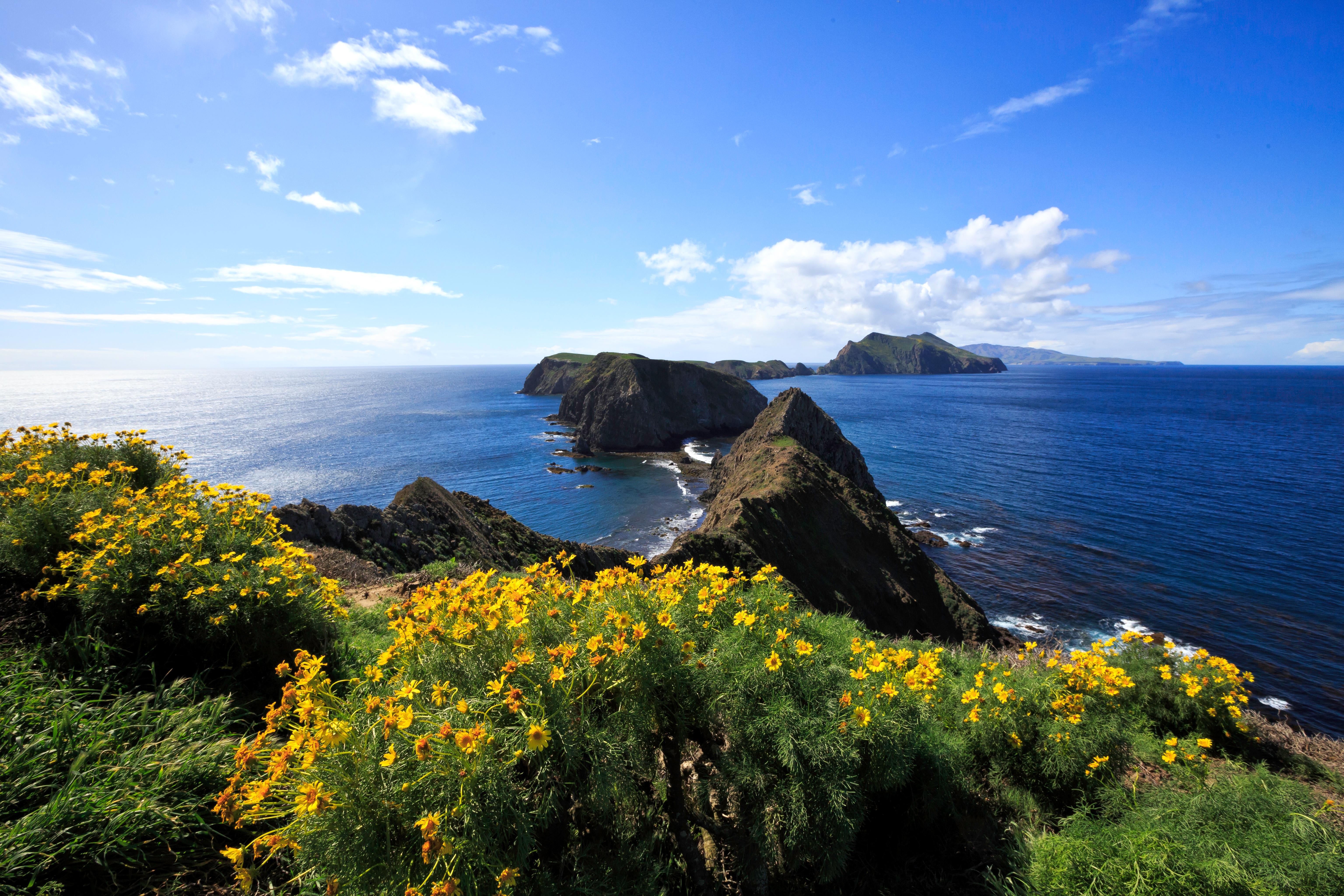
NPS via NPS.gov (Public Domain)
Channel Islands National Park Weather
9 min read
Weather Guide
Channel Islands weather is defined by wind, not temperature. Learn how wind and ocean conditions dictate your 2026 trip to this coastal park.
The Weather Reality
The islands have a Mediterranean climate, which means mild, wet winters and dry, cool summers. That is the textbook answer. The reality is more specific. The ocean is the thermostat. Highs average in the mid-60s Fahrenheit year-round, and lows hover in the low-50s. You will not find extreme heat or bitter cold here.
What you will find is microclimates. The north side of an island can be shrouded in fog while the south side is sunny. Santa Rosa Island, farther out in the channel, is often windier and cooler than Santa Cruz. The marine layer - a blanket of low clouds and fog - is a dominant feature from late spring into early fall. It typically burns off by midday, but on some days it does not burn off at all. This is not a passing weather event; it is the default condition for many summer mornings.
The wind follows a predictable daily pattern. Mornings are often calm. The northwest wind, locally called the "Catalina Eddy" or just the afternoon breeze, begins to build around 11 AM. It peaks in the late afternoon, often between 2 PM and 4 PM, and then begins to die down around sunset. This matters for everything: ferry crossings are rougher in the afternoon, hiking exposed trails becomes a battle, and setting up a tent requires extra stakes.
Forget checking one forecast. You need to check three: the mainland (Ventura), the specific island you are visiting, and the marine forecast for the Santa Barbara Channel. The marine forecast is the most important one. It tells you about wind speed, wave height, and swell direction - the factors that determine if the boats run and if you will be comfortable on the water.

Month by Month
The park remains accessible throughout the year, but what you can actually do and enjoy changes significantly with each season. Visitor numbers correlate directly with school calendars and predictable weather windows.
December - February (Winter)
Temperatures range from highs around 60°F to lows in the upper 40s. This is the rainy season, with most of the park's annual precipitation falling as rain. Storms can be intense, bringing high winds and large swells that cancel boat service for days. The ocean is cold, averaging in the mid-50s.
* What's Open/Closed: All islands are open, but access is entirely dependent on boat schedules, which are frequently disrupted. The mainland visitor center in Ventura remains open.
* Crowd Level: Very low. You might have an entire campground to yourself - if you can get there.
* Wildlife: Peak time for gray whale migrations. You have a strong chance of seeing them from the ferry or island bluffs. Elephant seals begin hauling out on beaches, particularly on San Miguel and Santa Rosa.
* Trail Conditions: Trails are green, muddy, and slippery after rains. Creek crossings that are dry most of the year can be running.
* Worth Considering For: Solitude, dramatic storm-watching from the mainland, and whale watching.
* Challenging Because: Trip cancellations are common. You must be flexible. Days are short, and hypothermia is a real risk if you get wet.
March - May (Spring)
This is the transition. Temperatures climb slowly into the mid-60s. Rain becomes less frequent, tapering off by May. The infamous "May Gray" sets in, with persistent morning fog and marine layer.
* What's Open/Closed: Full service resumes as weather stabilizes. This is the start of the main visitor season.
* Crowd Level: Moderate, building through May. Weekdays are quiet.
* Wildlife: Wildflower blooms peak, especially on the grassy slopes of Santa Rosa and San Miguel. Shorebird nesting activity increases. Harbor seal and sea lion pups are present.
* Trail Conditions: Excellent. Trails are firm, green, and not yet overgrown. This is arguably the best time for hiking the channel islands.
* Worth Considering For: The most reliable combination of pleasant weather, manageable crowds, and vibrant landscapes.
* Challenging Because: The marine layer can linger all day, creating cool, damp conditions. Water temperatures are still cold for swimming.
June - September (Summer)
The classic visitor season. Highs are in the low to mid-70s, lows in the mid-50s. Rain is extremely rare. The pattern is set: calm, foggy mornings giving way to windy, sunny afternoons.
* What's Open/Closed: All concessionaire boats and tours are running at full schedule. This is also when water temperatures become more tolerable for swimming and snorkeling.
* Crowd Level: High, especially on weekends and on Santa Cruz Island. Campgrounds book up months in advance.
* Wildlife: Blue and humpback whales are commonly seen. Puffins and other seabirds are active around the sea cliffs. Island foxes are most visible around campgrounds at dawn and dusk.
* Trail Conditions: Trails are dry, dusty, and exposed. The hills turn golden brown. There is little shade. The afternoon wind is a constant companion on ridge hikes.
* Worth Considering For: Predictable boat schedules, long days, and the best chance for calm morning waters for kayaking.
* Challenging Because: The wind. The fog. The crowds. You must start hikes early to beat both the heat and the wind. The sun is intense - there is very little shade on most trails.
October - November (Fall)
Often called the "secret season." The marine layer breaks down. Temperatures remain mild, similar to spring. The first significant rainstorms may arrive in late November. The afternoon winds begin to diminish.
* What's Open/Closed: Boat schedules start to scale back, especially after October. Some services may be reduced.
* Crowd Level: Low to moderate. A noticeable drop after Labor Day.
* Wildlife: Whale watching can be good for late-season humpbacks. Bird migrations are underway.
* Trail Conditions: Good, though vegetation is dry. The air is often exceptionally clear, offering long-distance views to the mainland.
* Worth Considering For: The most stable, sunny weather of the year with fewer people. The water is at its warmest.
* Challenging Because: Services are reduced. Weather windows start to get shorter, with a higher chance of trip-altering storms as November progresses.

Best Times for Specific Activities
* Hiking: March through May. Cool temperatures, minimal wind, green landscapes, and firm trails. Early October is a close second for clear skies.
* Wildlife Viewing:
* Whales: Gray whales (December-April), Blue and Humpback whales (June-September).
* Elephant Seals: Peak haul-out for breeding is January-February on San Miguel.
* Island Foxes: Active year-round, but most visible in summer around human activity at dawn/dusk.
* Seabirds: Spring and summer for nesting activity (puffins, auklets).
* Kayaking & Snorkeling: Late July through September. This is when ocean water temperatures are least bone-chilling (high 60s) and morning conditions are most reliably calm. Always check the marine forecast.
* Stargazing: Fall and Winter. With reduced marine layer and longer nights, the islands' dark skies are exceptional. The lack of light pollution is profound.
* Photography: Spring for wildflowers and green hills. Fall for clear, crisp air and golden light. Winter for dramatic storm clouds and whale activity.

What to Pack by Season
The packing mantra for the Channel Islands is layers and wind protection. Cotton jeans and a sweatshirt are a recipe for misery.
All Seasons, No Exceptions:
* A waterproof, windproof jacket (not just water-resistant).
* A warm insulating layer (fleece or puffy).
* Sturdy, broken-in hiking shoes or boots with good traction.
* Wide-brimmed hat and sunglasses with UV protection.
* High-SPF sunscreen. The marine layer does not block UV rays.
* More water than you think you need. There is no potable water on the islands except at the Scorpion Canyon campground on Santa Cruz.
Spring/Fall: Add a lightweight beanie and gloves for morning ferry rides. Quick-dry hiking pants are ideal. A mid-weight base layer is wise.
Summer: A sun shirt is invaluable for hiking. Swimwear and a quick-dry towel. The windbreaker is still essential for afternoon gusts.
Winter: A heavy insulating layer, waterproof pants, warm hat, and gloves. Hand warmers are not overkill for a winter ferry crossing. Wear waterproof boots.

What the Forecast Doesn't Tell You
- The ferry ride is part of the weather. The crossing can be smooth in the morning and rough in the afternoon on the same day. If you are prone to seasickness, take medication before you board, not after you feel ill. The stern (back) of the boat typically has less motion.
- "Sunny" can mean "foggy until noon." Do not plan a short day trip expecting eight hours of sun. Schedule your most important hike or activity for the afternoon, or be prepared to hike in the cool, damp fog.
- Wind chill is real, even in summer. A 70°F day with a 20-knot wind feels much colder, especially if you are damp from ocean spray or sweat. That windproof layer is non-negotiable.
- Island weather changes faster. A front that takes hours to reach the mainland can sweep across the islands in minutes. Always carry your shell jacket, even if the sky looks clear.
- The microclimates are extreme. Rangers will tell you that the difference between the windward (north) and leeward (south) side of Santa Cruz Island can feel like different continents. If a trail is brutally windy, there is often a more sheltered route on the other side of the ridge.
- Dock conditions dictate access. As of 2026, Santa Barbara Island's dock is closed due to storm damage, requiring a tricky landing on a rocky ledge. This is a perfect example of how infrastructure is at the mercy of ocean conditions. Always check the park's website for current alerts on landing conditions.
- Your plans are not final until you are on the island. Boats are cancelled for wind, swell, or mechanical issues. Have a flexible schedule and a backup plan for your day if you get weathered in on the mainland.
Practical Takeaways
- Check the marine forecast, not just the weather app. The National Weather Service's "Santa Barbara Channel" forecast is your most critical document. Look for wind speeds under 15 knots and wave heights under 4 feet for ideal conditions.
- Book the earliest ferry you can. Morning crossings are calmer. This also gives you a head start on hiking before the afternoon wind peaks.
- Pack for a 20-degree temperature range and high wind. Your pack should always contain a warm layer, a wind/rain shell, sun protection, and extra water.
- For the best balance of weather, crowds, and scenery, target April-May or late September-October. These windows offer the highest probability of good weather with fewer logistical headaches.
- If your primary goal is hiking, spring is superior to summer. You will trade warmer water for cooler air, less wind, and more vibrant trails. For a complete visitor guide covering all logistics, see our complete visitor guide.
- Have a Plan B. Know what you will do in Ventura if your boat is cancelled. Conversely, know the sheltered hikes and coves on your island if the wind picks up unexpectedly.
- Respect the ocean's power. This is a wilderness where help is not readily available. Conditions dictate what is safe. Turning back from a kayak trip or cutting a hike short because of weather is not a failure - it is the correct decision.
The Channel Islands National Park weather is defined by the sea. Prepare for its influence, and you will be rewarded with an experience that feels worlds away from the California coast, because it is.
Related: channel islands national park guide
Sources
- Official source: NPS — Channel Islands National Park nps.gov/chis/index.htm
Photo Gallery
More to Explore

Park Guide
Acadia National Park: Carriage Roads, Cadillac Mountain & 2026 Guide
Discover carriage roads, Cadillac Mountain, and rugged Maine coast. Complete 2026 guide to Acadia National Park — trails, fees, lodging, permits, and what rangers recommend.

Hiking Guide
Grand Canyon Hiking Trails: Day Hikes, Water Sources & Rim to Rim
Compare Grand Canyon hiking trails: Bright Angel, South Kaibab, Hermit, Grandview, and rim to rim, with distances, elevation, water stops, and trailhead access for each.

Best Of
Best of Glacier Bay National Park
The best of Glacier Bay is reached by boat: ranger-led day tours up the bay to the tidewater glaciers. What's worth it, how to book, and when to go (2026).

Campsite Guide
White Sands Backcountry Camping: Closed for 2026 — What to Know
As of 2026, backcountry camping at White Sands National Park is closed for site rehabilitation. What that means, and where to camp nearby instead.

Weather Guide
Guadalupe Mountains National Park Weather: Weather
Guadalupe Mountains National Park: weather guide guide updated 2026. Practical visitor information, reservations, and seasonal tips worth bookmarking before

Best Of
Best of Cuyahoga Valley National Park: Best Things to Do
Seeing a Cleveland Orchestra concert with the woods as your backdrop is a uniquely Cuyahoga Valley experience.
Sign in to join the conversation.
Sources & Attribution
Location data courtesy of the National Park Service (U.S. Department of the Interior). NPS data is public domain. Official NPS page.
Images: NPS; NPS; NPS; NPS; NPS.
Map data © OpenStreetMap contributors.
Park operations alerts: NPS.gov · Weather and weather hazards: National Weather Service · Live conditions.
Information may change. Always verify fees, hours, and conditions directly with the official source before visiting.
Did this guide help? Share it with a friend.