Channel Islands National Park Hiking: Hiking In (2026 Guide)
NPS via NPS.gov (Public Domain)
Hiking in Channel Islands National Park
10 min read
Hiking Guide
Complete 2026 hiking guide for Channel Islands National Park. Trails, difficulty ratings, seasonal conditions, and practical tips for every skill level.
This article contains affiliate links — we may earn a small commission at no extra cost to you.
Forget trail grade or mileage. The defining feature of hiking in Channel Islands National Park is the boat ride across the Santa Barbara Channel. This logistical reality shapes the entire experience. You're committing to a full day or overnight trip, your schedule tethered to the ferry timetable. The terrain is exposed, with little shade, and trails are often steep and rocky. Most newcomers underestimate the relentless wind and the intense sun on those open bluffs. This isn't a park for a casual stroll. It's for those who plan meticulously, understanding that the rewards—solitude, unique wildlife, raw coastal scenery—are earned through thorough preparation.
What Hiking Here Actually Means
Hiking here is a logistical puzzle before it's a physical one. You're not selecting trails; you're selecting islands, each with distinct ferry schedules, landing conditions, and trail systems. Though technically front-country, the isolation makes it feel profoundly remote. Trails are well-defined yet rugged, traversing grasslands, climbing coastal bluffs, and descending into canyons. Expect no services—no water, no concessions, no cell signal. You carry everything in.
The common mistake, and almost everyone makes it, is focusing only on distance. A 4-mile hike here can be more demanding than an 8-mile hike on the mainland, thanks to constant sun exposure, wind that saps your energy, and trail surfaces of loose rock or packed clay. Your fitness matters, but your preparation matters more. Successful hiking in the Channel Islands is about water carry, sun protection, and timing your return to the landing cove before the boat leaves. Miss that boat, and you're camping overnight whether you planned to or not.
Santa Cruz Island: The Main Event
As the largest island with the most frequent ferry service, Santa Cruz is where most visitors experience hiking the Channel Islands. The trails from Scorpion Anchorage offer the greatest variety, from easy valley walks to strenuous ridge climbs with ocean views that stretch for miles.
Scorpion Canyon Loop: The Introductory Workhorse
Distance: 4.5 miles round trip
Elevation Gain: 800 feet
Trailhead & Parking: The trail begins directly from the Scorpion Anchorage landing beach. There is no parking lot - your "trailhead" is the beach where you step off the Island Packers boat. Everyone on your ferry will start here, so expect a cluster of people for the first ten minutes until the crowd spreads out.
The Trail: You'll start on a wide, flat road past the historic ranch buildings before turning into Scorpion Canyon. The trail narrows here, becoming a dirt path that climbs steadily up the canyon floor under scattered oak trees. The return leg typically follows the Cañada del Puerto trail along a higher ridge, offering views back down the canyon and across the channel to the mainland. The surface is a mix of packed dirt and loose scree; trekking poles are useful on the descent.
The Moment: Reaching the high point on the ridge and getting your first unobstructed view of the entire north shore of Santa Cruz, with Anacapa Island a faint bump on the horizon.
What Most Underestimate: The complete lack of shade on the ridge section. What feels like a pleasant canyon hike becomes a sun-exposed trudge if you're not prepared with a hat and sunscreen.
Best Time: Start as soon as you get off the boat. You'll beat the main crowd and have the ridge to yourself. The light is best in the morning, anyway.
Smugglers Cove Trail: The Coastal Grind
Distance: 8 miles round trip
Elevation Gain: 1,500 feet
Trailhead & Parking: Also starts at Scorpion Anchorage. Look for the signed junction just past the ranch complex.
The Trail: This is a serious hike. The trail climbs over the island's central ridge via a relentless series of switchbacks before dropping down the south side to a secluded pebble beach. The ascent is exposed and can be hot. The descent to the cove is steep and rocky. Rangers will tell you to allow at least 4-5 hours total, and they're not exaggerating. The cove itself is often windy.
The Moment: The first glimpse of Smugglers Cove itself - a perfect crescent of beach framed by cliffs, completely inaccessible by road. You'll have earned the view.
What Most Underestimate: The difficulty of the return trip. That steep, rocky descent to the cove becomes a grueling climb back out. Many hikers run low on water here.
Best Time: An early ferry is mandatory. Only attempt this if you're on the first boat of the day and have confirmed the return ferry time with the captain. Late spring (May-June) offers the best chance of calm winds and wildflowers.
Potato Harbor Overlook: The View for the Effort-Averse
Distance: 5 miles round trip
Elevation Gain: 600 feet
Trailhead & Parking: From Scorpion Anchorage, follow the North Bluff Trail west.
The Trail: A relatively flat, wide trail that follows the top of dramatic sea cliffs the entire way. The footing is good, and the views are constant. It's less of a hike and more of a scenic walk with one destination. The overlook at Potato Harbor is a sheer cliff dropping hundreds of feet to a deep, circular cove.
The Moment: Peering over the edge at Potato Harbor. The water color shifts from deep blue to emerald green.
What Most Underestimate: The wind. On the exposed bluffs, it can be strong enough to make you stagger. Hold onto your hat.
Best Time: Late afternoon. The sun is at your back for the walk out, lighting up the cliffs beautifully. Just be absolutely certain of your ferry's departure time.

Anacapa Island: The Short & Steep
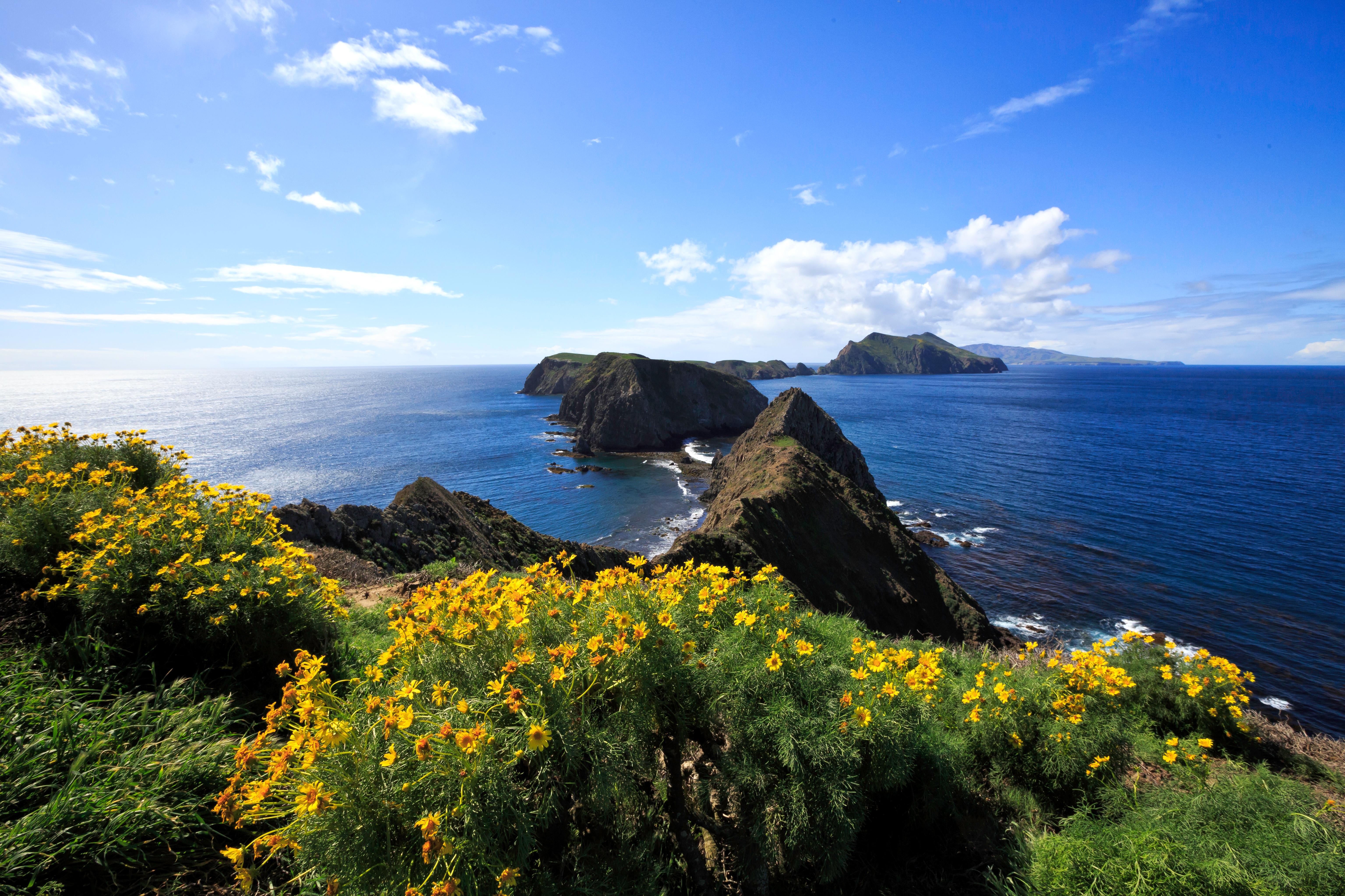
Anacapa is actually three small islets. Visitors land on East Anacapa, which is essentially a long, narrow ridge. Hiking here is about stairs and seabirds.
Inspiration Point & Island Loop
Distance: 2 miles round trip for the full loop
Elevation Gain: 300 feet (mostly via stairs)
Trailhead & Parking: The trail starts at the top of the famous 154-step staircase from the landing cove. There is no alternative.
The Trail: A concrete and packed dirt path circles the island plateau. It's mostly flat once you're up the stairs, with interpretive signs describing the island's history and ecology. The trail to Inspiration Point is a short spur at the west end. The entire "hike" is more of a narrated walk.
The Moment: Standing at Inspiration Point, looking west at the Middle and West Anacapa islets, with Santa Cruz Island looming beyond. It's the iconic view.
What Most Underestimate: The staircase. Climbing 154 steps with a daypack after a boat ride is a wake-up call. The smell of guano from the massive seabird colonies is also... potent.
Best Time: Any time. The island is small, and you'll see it all regardless. Mornings are less crowded if multiple ferries are scheduled.
Santa Rosa Island: The Wild & Windy
The second-largest island feels far more remote. The ferry ride is longer, and the landscape is broader - rolling grasslands, vast dunes, and lonely beaches. Check the complete visitor guide for current alerts, as parts of Santa Rosa may be closed for resource protection, like the temporary closure near China Camp as of 2026.
Cherry Canyon Trail
Distance: 5.5 miles round trip to the canyon overlook
Elevation Gain: 900 feet
Trailhead & Parking: Starts from the historic ranch buildings at the landing area at Bechers Bay.
The Trail: A well-graded dirt road that climbs steadily from the ranch into the island's interior. The road narrows to a trail as it enters Cherry Canyon, with stands of island oaks and coreopsis. The overlook provides a sudden, sweeping view back toward the coast.
The Moment: The transition from open grassland to the sheltered, oak-filled canyon. The temperature drops noticeably, and the wind finally stops.
What Most Underestimate: The sheer size of the landscape. Distances are deceiving on Santa Rosa. What looks like a short walk can be miles away.
Best Time: Spring. This is when the island's unique wildflowers, like the giant coreopsis, are in bloom, transforming the grasslands.
Water Canyon Beach Trail
Distance: 3 miles round trip
Elevation Gain: 200 feet
Trailhead & Parking: Also from the Bechers Bay area.
The Trail: A straightforward hike down a canyon to a long, white-sand beach. This is one of the easier beach accesses in the park. The trail is sandy and can be soft in places.
The Moment: Emerging from the canyon mouth onto the vast, empty beach. You'll often have it completely to yourself.
What Most Underestimate: The strength of the surf and currents. Swimming here is for strong swimmers only, and even then, with extreme caution.
Best Time: Low tide. You'll have more beach to explore and can look for tide pools in the rocky areas.

Seasonal Trail Conditions
Conditions don't change dramatically month-to-month like in mountain parks, but timing still matters.
December - March: The green season. Hills are lush, creeks may run in the canyons, and temperatures are cool (50s-60s). This is also the rainiest and windiest period. Boat crossings can be rough, and trips are frequently canceled due to weather. Whale watching is prime.
April - June: The best balance. Wildflowers peak (especially the coreopsis bloom on Santa Rosa in April), temperatures are pleasant, and the summer fog hasn't settled in yet. Winds begin to subside. This is the ideal window for hiking the Channel Islands.
July - September: Summer fog is common, especially in the morning, often burning off by afternoon. Temperatures are at their highest, but rarely exceed 80°F on the islands. The lack of rain means trails are dusty, grasses are golden brown, and water sources are nonexistent. This is the busiest season for visitors.
October - November: A second excellent window. The fog is usually gone, winds are typically calm, and the water is at its warmest for kayaking or snorkeling. Crowds diminish after Labor Day. This is a top choice for a visit.
Trailhead Logistics
Forget parking lots. Your logistics are maritime.
The "Trailhead" is a Boat Dock: You must book passage with the park's concessionaire, Island Packers, well in advance. Schedules vary by island and season. The last boat out is non-negotiable.
Cell Service: Drops out within sight of the Ventura harbor. Assume you will have zero service for the entire duration of your island visit.
Water Sources: There are no potable water sources on any of the trails. There is limited water available at the Scorpion Ranch campground on Santa Cruz and the landing areas on Santa Rosa and Anacapa for campers, but day hikers must carry all the water they will need for the entire day. That's at least one gallon per person.
Ranger Stations: There are small ranger stations at Scorpion Anchorage (Santa Cruz) and the landing areas on Anacapa and Santa Rosa. Check in here upon arrival for the latest trail conditions and any area closures. Rangers post daily weather and trail updates.

What to Carry
Your gear list for hiking in Channel Islands National Park has non-negotiable additions beyond the standard essentials.
Water: One gallon per person, per day. Not liters. Gallons. In soft-sided bladders or multiple bottles. There is no refill option.
Sun Protection: A wide-brimmed hat, sunglasses, and mineral-based sunscreen (the sweat-resistant kind). The sun reflects off the ocean and the light-colored trails. You will burn faster than you think.
Wind Layer: A lightweight but windproof jacket is essential year-round. A fleece underneath for cooler months. The wind chill is real.
Footwear: Sturdy hiking shoes or boots with good traction. Trail runners can work on the flatter paths, but the rocky, uneven surfaces on most trails demand ankle support and a stiff sole. Sandals are only for the beach after your hike.
Navigation: A physical map. The park map you get from the visitor center or ferry is sufficient for the main trails. Do not rely on your phone's GPS.
Food: More than you think you need. The sea air and exertion increase appetite. Pack salty snacks to replace electrolytes.
Practical Takeaways
- Book your ferry first, then plan your hike. Your entire day is built around the boat schedule.
- Pack extra water for this stretch. A gallon per person is the minimum. Dehydration is the most common issue rangers address.
- Dress in layers you can add or remove quickly. The temperature can swing 20 degrees from a sunny canyon to a windy bluff.
- Footwear matters. The trails are rocky, uneven, and often steep. Your everyday sneakers won't cut it.
- Check the camping options if you want to explore more trails. A single day limits you to one island's network.
- Verify the best time to visit for your priorities - wildflowers, whale watching, or calm seas.
- Your return ferry time is a hard deadline. Start your hike back to the landing cove at least an hour before that time to account for slow paces or unexpected delays.
- The gift shop on the ferry sells water and snacks, but at a premium. Bring your own.
- Leave no trace means everything you carry in, you carry out - including all trash. There are no trash cans on the islands.
- Weather cancellations happen. Have a flexible schedule or a backup plan for your trip dates.
Recommended Gear
What experienced visitors bring to Hiking in Channel Islands National Park
Links may earn us a commission at no extra cost to you. We only recommend gear we believe in.
Hiking Essentials
Hydration Pack (3L)
Hands-free water for long trail days
Trekking Poles (Pair)
Save your knees on steep descents
Hiking Boots (Ankle Support)
Sturdy footwear for rocky, uneven trails
Sun & Heat Protection
Wide-Brim Sun Hat
Full coverage UPF 50+ protection at altitude
Insulated Water Bottle (32oz)
Keeps water cold in desert heat all day
Electrolyte Mix Packets
Replace what water alone cannot during intense heat
Winter Gear
Microspikes / Traction Devices
Essential for icy rim trails in winter months
Packable Down Jacket
Lightweight warmth that stuffs into a pocket
Sources
- Official source: NPS — Channel Islands National Park nps.gov/chis/index.htm
Photo Gallery
More to Explore

Park Guide
Acadia National Park: Carriage Roads, Cadillac Mountain & 2026 Guide
Discover carriage roads, Cadillac Mountain, and rugged Maine coast. Complete 2026 guide to Acadia National Park — trails, fees, lodging, permits, and what rangers recommend.

Hiking Guide
Grand Canyon Hiking Trails: Day Hikes, Water Sources & Rim to Rim
Compare Grand Canyon hiking trails: Bright Angel, South Kaibab, Hermit, Grandview, and rim to rim, with distances, elevation, water stops, and trailhead access for each.

Best Of
Best of Glacier Bay National Park
The best of Glacier Bay is reached by boat: ranger-led day tours up the bay to the tidewater glaciers. What's worth it, how to book, and when to go (2026).

Campsite Guide
White Sands Backcountry Camping: Closed for 2026 — What to Know
As of 2026, backcountry camping at White Sands National Park is closed for site rehabilitation. What that means, and where to camp nearby instead.

Weather Guide
Guadalupe Mountains National Park Weather: Weather
Guadalupe Mountains National Park: weather guide guide updated 2026. Practical visitor information, reservations, and seasonal tips worth bookmarking before

Best Of
Best of Cuyahoga Valley National Park: Best Things to Do
Seeing a Cleveland Orchestra concert with the woods as your backdrop is a uniquely Cuyahoga Valley experience.
Sign in to join the conversation.
Sources & Attribution
Location data courtesy of the National Park Service (U.S. Department of the Interior). NPS data is public domain. Official NPS page.
Images: NPS; NPS; NPS; NPS; NPS.
Map data © OpenStreetMap contributors.
Park operations alerts: NPS.gov · Weather and weather hazards: National Weather Service · Live conditions.
Information may change. Always verify fees, hours, and conditions directly with the official source before visiting.
Did this guide help? Share it with a friend.