For more, see hiking trails, camping options, lodging and accommodations, and best time to visit.
NPS via NPS.gov (Public Domain)
Bunkhouse: Your Complete 2026 Guide to Planning the Perfect Visit
10 min read
Places & Points of Interest
Plan your 2026 visit to Bunkhouse. Complete guide to trails, fees, lodging, best time to visit, and insider tips.
Your plans
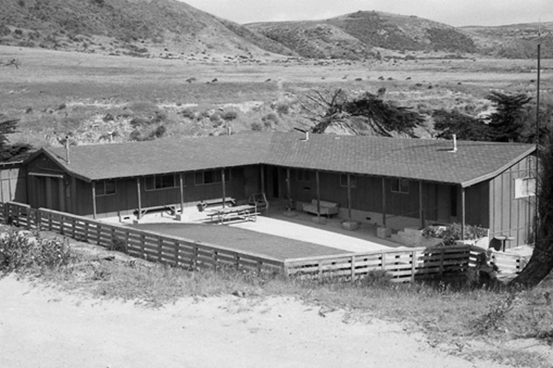
The current bunkhouse on Santa Cruz Island dates to 1970, replacing the original that burned. For decades, that first structure sheltered ranch crews, a reminder that visiting these islands demands more forethought than most parks. You won't drive here. Your trip depends on boat schedules, weather, and what you can carry. The bunkhouse embodies the park's working past and a straightforward truth: come prepared.
Overview
Channel Islands National Park comprises five islands off Southern California: Anacapa, Santa Cruz, Santa Rosa, San Miguel, and Santa Barbara. It protects over 250,000 acres, but the critical figure is 11—the miles separating Anacapa from the mainland. That distance shapes everything. These islands earn the nickname "Galapagos of North America" through evolutionary isolation, not tropical scenery. More than 150 plant and animal species are found nowhere else.
Step off the boat, and the air changes—salt spray, blooming coreopsis, and the seasonal musk of seabirds or seals. Engine noise gives way to wind, surf, and the calls of gulls. Forget restaurants or paved roads; here, trails may bring only an island fox for company, and the mainland appears as a distant haze, a view known to few.
Quick Information
* Entrance Fee: There is no traditional entrance fee for Channel Islands National Park. However, access requires a paid boat or plane concessionaire service. As of 2026, round-trip boat fares from Ventura or Oxnard range from approximately $65 to over $100 per person, depending on the island and season. Park concessionaire fees apply separately.
* Hours: The islands are open 24/7, but access is limited to concessionaire operating hours. Mainland visitor centers in Ventura and Santa Barbara have typical daytime operating hours. Boat crossings are generally day trips, with limited multi-day options for campers.
* Best Time to Visit: Late spring (May-June) and early fall (September-October) offer the most reliable weather, calmest seas, and peak wildflower displays. Summer brings fog and stronger winds, especially to the outer islands. Winter can be stormy, with more frequent trip cancellations.
* Location: Off the coast of Southern California. Primary mainland departure points are Ventura and Oxnard. The park's mainland visitor center is at 1901 Spinnaker Drive, Ventura, CA.
* Accessibility: Terrain is rugged and largely undeveloped. The only wheelchair-accessible trails are the short, paved paths at the Scorpion Canyon area on Santa Cruz Island and around the Anacapa Island lighthouse. The boat landing at Anacapa requires climbing a steel-rung ladder; other landings are typically onto docks or, at Santa Barbara Island as of 2026, onto a rocky ledge due to dock damage.
* Cell Service: Unreliable to non-existent on all islands. Assume you will have no signal.
* Restrooms: Available at island landing areas and campgrounds. All are primitive pit or composting toilets. No running water is available except for limited potable water at the Scorpion Ranch campground on Santa Cruz Island (must be treated).
* Parking: Paid parking (approx. $10-$15/day) is available at the Ventura and Channel Islands harbors where concessionaire boats depart. Lots can fill on summer weekends. Arrive at least 45-60 minutes before your scheduled departure.

Getting There
You cannot drive to this park. Your journey starts with a reservation on one of the park-authorized concessionaire boats, which depart from Ventura Harbor (primary) or Channel Islands Harbor in Oxnard. The crossing takes about 1 hour to Anacapa, 2-3 hours to Santa Cruz (Scorpion Anchorage), and 3-4+ hours to the outer islands (Santa Rosa, San Miguel). These are open-ocean crossings; seas can be rough. If you are prone to motion sickness, medication is not a suggestion - it's a requirement. Pack it and take it early.
Flights are available to Santa Rosa Island via a small plane service from Camarillo. This is the fastest access but has strict baggage weight limits, making it challenging for campers with full gear. For most visitors, the boat is the only option. There is no public transportation to the harbors. Your planning begins and ends with the concessionaire schedule; a missed boat means a missed trip, as there are no standby options for day hikers. Campers with reservations are typically accommodated on later boats if space allows, but it's not guaranteed.
What to Expect
Expect a backcountry experience reached by boat. The islands are not themed attractions; they are wild, exposed, and weather-dependent. Rangers emphasize that you must be self-sufficient: bring all your own food, water (minimum 1 gallon per person per day), sun protection, and first-aid supplies. There are no stores, no vending machines, and no shade structures.
The terrain varies dramatically. On Santa Cruz, you can hike through deep, oak-filled canyons. On Anacapa, you'll traverse a narrow, flat spine of an island with sheer cliff drops on either side. San Miguel and Santa Rosa are vast, treeless grasslands swept by constant wind. The most common surprise for first-time visitors is the wind. It can howl across the bluffs, making conversation difficult and chilling you even on a sunny day. The second surprise is the island fox - a cat-sized endemic fox that has no fear of humans. Do not feed them. They will investigate your backpack if left unattended.
Your day will be dictated by the boat schedule. You'll typically have 4-6 hours on an island for a day trip. That means choosing one or two activities and accepting that you won't see everything. The pace is slower, the stakes are higher, and the reward is a genuine sense of discovery.

Top Attractions & Points of Interest
Arch Rock (Anacapa Island)
This is the park's iconic symbol - a massive sea arch carved from volcanic rock. You'll see it from the boat as you approach East Anacapa. The best land-based view is from the Inspiration Point overlook, a short, flat walk from the landing. At sunset, the arch glows. The Chumash name, pasawapʰ hoti, means "house of the cormorant," and you'll often see seabirds swirling around it.
Scorpion Canyon (Santa Cruz Island)
The main landing area for Santa Cruz, this historic ranch complex is the gateway to the island's best hiking trails. From here, you can hike up Scorpion Canyon to see the historic bunkhouse and other ranch buildings, or head east to Smugglers Cove or west to Potato Harbor. The area is rich with island fox activity.
Cavern Point & Potato Harbor Overlook (Santa Cruz Island)
A moderate 2-mile loop from Scorpion Ranch that delivers what many come for: vast, unobstructed views of the Santa Cruz coastline. From Cavern Point, you look down at sea caves. Potato Harbor is a perfect crescent of blue water 300 feet below. This is the hike rangers recommend if you only have time for one.
The Landing Cove Ladder (Anacapa Island)
Access to the top of Anacapa is an adventure in itself. You'll transfer from the boat to a small skiff, then climb a fixed steel-rung ladder up a vertical cliff face to the landing dock. It's stable and safe, but not for those with a severe fear of heights. It sets the tone for the visit immediately.
Prisoners Harbor Wetland (Santa Cruz Island)
The largest wetland on the northern islands and a vital freshwater source. Access is via the boat that lands at Prisoners Harbor (less frequent than Scorpion). It's a hotspot for bird watching and a starting point for the challenging but rewarding hike to the historic Pelican Bay site.
Activities
Hiking
Hiking is the primary activity. Trails range from the paved, flat path to the Anacapa Island lighthouse (0.5 miles) to the strenuous 15-mile round-trip trek to San Miguel's Caliche Forest. On Santa Cruz, the network from Scorpion Ranch most abilities. Always check with rangers for current trail conditions; some routes may be overgrown or closed for wildlife protection.
Kayaking and Snorkeling
The kelp forests here are among the best in the world. Guided sea cave kayaking tours operate out of Scorpion Anchorage on Santa Cruz Island (booked through the concessionaire). Snorkeling is excellent in the protected coves around Anacapa and Santa Cruz. You must bring all your own gear; rentals are extremely limited and must be arranged in advance on the mainland.
Wildlife Viewing
This is world-class wildlife viewing. From April through July, islands like Anacapa become deafening seabird rookeries for western gulls, pelicans, and cormorants. Elephant seals and sea lions haul out on specific beaches year-round, with pupping season in winter. The endemic island fox is commonly seen on Santa Cruz, Santa Rosa, and San Miguel. Whale watching is possible from the boat during migration seasons (gray whales in winter/spring, humpbacks in summer).
Camping
Camping is primitive and requires planning. Reservations are competitive, especially for the small campgrounds on Anacapa (7 sites) and Santa Barbara (7 sites). The camping options on Santa Cruz at Scorpion Canyon (31 sites) are the most accessible. You must pack in all water or have a reliable filter for the limited sources. Backcountry beach camping is available on Santa Rosa and Santa Cruz, but involves significant hiking with all gear.

Seasonal Guide
* Spring (March-May): The best overall season. Wildflowers peak (coreopsis creates yellow carpets), temperatures are mild (60s-70s°F), seas are often calmer, and wildlife is active. This is the most popular time; book boats and campsites months in advance.
* Summer (June-August): Expect a marine layer of fog, especially in the morning ("June Gloom"). Wind picks up on the outer islands. It's the busiest season for day trips. Water temperatures are warmest for swimming and snorkeling. Afternoon sun is intense.
* Fall (September-November): Another excellent window. Fog dissipates, water remains warm, and crowds thin after Labor Day. The best chance for clear, calm days. Whale watching opportunities shift to blue and humpback whales.
* Winter (December-February): The quietest and most unpredictable season. Storms can cancel boat trips for days. The reward is storm-watching drama, green hills, and elephant seal pupping season on beaches like Santa Rosa's. Only for the flexible and well-prepared.
For a detailed monthly breakdown, see our guide on the best time to visit.
Practical Information
All camping requires a reservation through Recreation.gov. As of 2026, island campground fees are $15 per night per site for standard sites, with group sites at $40. These fees are separate from your transportation costs. There is no lodging and accommodations on the islands beyond campgrounds; all overnight stays are in tents.
On the mainland, Ventura and Oxnard offer full hotel and restaurant services. The park's visitor center in Ventura has exhibits, a film, and rangers who can provide last-minute advice. Concessionaire boats have small snack bars, but you should bring your own lunch. All gear, including kayaks and snorkels, must be arranged with the concessionaire prior to departure - you cannot show up with your own kayak and expect to bring it.

Safety & Preparation
Ocean Crossings: The single biggest safety factor is the boat crossing. Listen to the crew's safety briefing. If you feel ill, get on deck to the leeward rail. The concessionaire will cancel trips if conditions are unsafe.
Dehydration & Sun Exposure: These are the most common on-island issues. There is little shade. Carry and drink more water than you think you need. Wear a hat, sunglasses, and reef-safe sunscreen.
Island Foxes: They are clever and will steal food in seconds. Never feed them. Use the provided food storage boxes at campgrounds and never leave packs unattended.
Cliff Edges: Trails often run along sheer cliffs hundreds of feet high. Stay on designated paths and keep children close. Wind gusts can be sudden.
Emergency: There are no medical facilities on the islands. Rangers may be present, but response times are long. Carry a comprehensive first-aid kit and know how to use it. In an emergency, your group may need to signal the concessionaire boat or, if possible, use a satellite communication device.
Insider Tips
- The Backpack Check: Rangers at the visitor center will visually inspect your pack if you ask. They'll point out if you've forgotten something critical (like water) or brought something you shouldn't (like glass containers).
- Anacapa for a Half-Day: If you're short on time or unsure about your sea legs, Anacapa is the closest island. The 1-hour crossing and compact trail system mean you can experience the park's essence in a 4-5 hour trip.
- Eat on the Boat: Use the return crossing for lunch. It saves precious exploration time on the island and gives you a stable(ish) table.
- The Windward Side: On any island, the windward (northwest) side will be cooler, windier, and often foggier. The leeward side is more sheltered and sunny. Plan your layers accordingly.
- Target the Weekday: If your schedule allows, go on a Tuesday, Wednesday, or Thursday. You'll share the island with dozens instead of hundreds.
- Check the Webcam: Before you go, look at the Anacapa Island webcam on the park website. It gives a real-time view of weather conditions on the island itself, which can be drastically different from Ventura.
- Skip the Fancy Shoes: Trail runners or sturdy hiking shoes are perfect. The trails are dirt, rock, and sometimes mud. Heavy hiking boots are overkill for most maintained trails.
Links may earn us a commission at no extra cost to you. We only recommend gear we believe in. For this trip, a comfortable, well-fitting daypack, a 2-3 liter water bladder, and a lightweight but warm windbreaker are non-negotiable pieces of gear.
For more information, see our complete Channel Islands National Park Guide.
Sources
- Official source: NPS — Channel Islands National Park nps.gov/chis/index.htm
- Official source: National Park Service nps.gov/places/000/bunkhouse.htm
Photo Gallery
More to Explore

Park Guide
Acadia National Park: Carriage Roads, Cadillac Mountain & 2026 Guide
Discover carriage roads, Cadillac Mountain, and rugged Maine coast. Complete 2026 guide to Acadia National Park — trails, fees, lodging, permits, and what rangers recommend.

Hiking Guide
Grand Canyon Hiking Trails: Day Hikes, Water Sources & Rim to Rim
Compare Grand Canyon hiking trails: Bright Angel, South Kaibab, Hermit, Grandview, and rim to rim, with distances, elevation, water stops, and trailhead access for each.

Best Of
Best of Glacier Bay National Park
The best of Glacier Bay is reached by boat: ranger-led day tours up the bay to the tidewater glaciers. What's worth it, how to book, and when to go (2026).

Campsite Guide
White Sands Backcountry Camping: Closed for 2026 — What to Know
As of 2026, backcountry camping at White Sands National Park is closed for site rehabilitation. What that means, and where to camp nearby instead.

Weather Guide
Guadalupe Mountains National Park Weather: Weather
Guadalupe Mountains National Park: weather guide guide updated 2026. Practical visitor information, reservations, and seasonal tips worth bookmarking before

Best Of
Best of Cuyahoga Valley National Park: Best Things to Do
Seeing a Cleveland Orchestra concert with the woods as your backdrop is a uniquely Cuyahoga Valley experience.
Sign in to join the conversation.
Sources & Attribution
Location data courtesy of the National Park Service (U.S. Department of the Interior). NPS data is public domain. Official NPS page.
Images: NPS; NPS; NPS; NPS; NPS.
Map data © OpenStreetMap contributors.
Park operations alerts: NPS.gov · Weather and weather hazards: National Weather Service · Live conditions.
Information may change. Always verify fees, hours, and conditions directly with the official source before visiting.
Did this guide help? Share it with a friend.