A Boat's Purpose: Everything You Need to Know - 2026 Guide
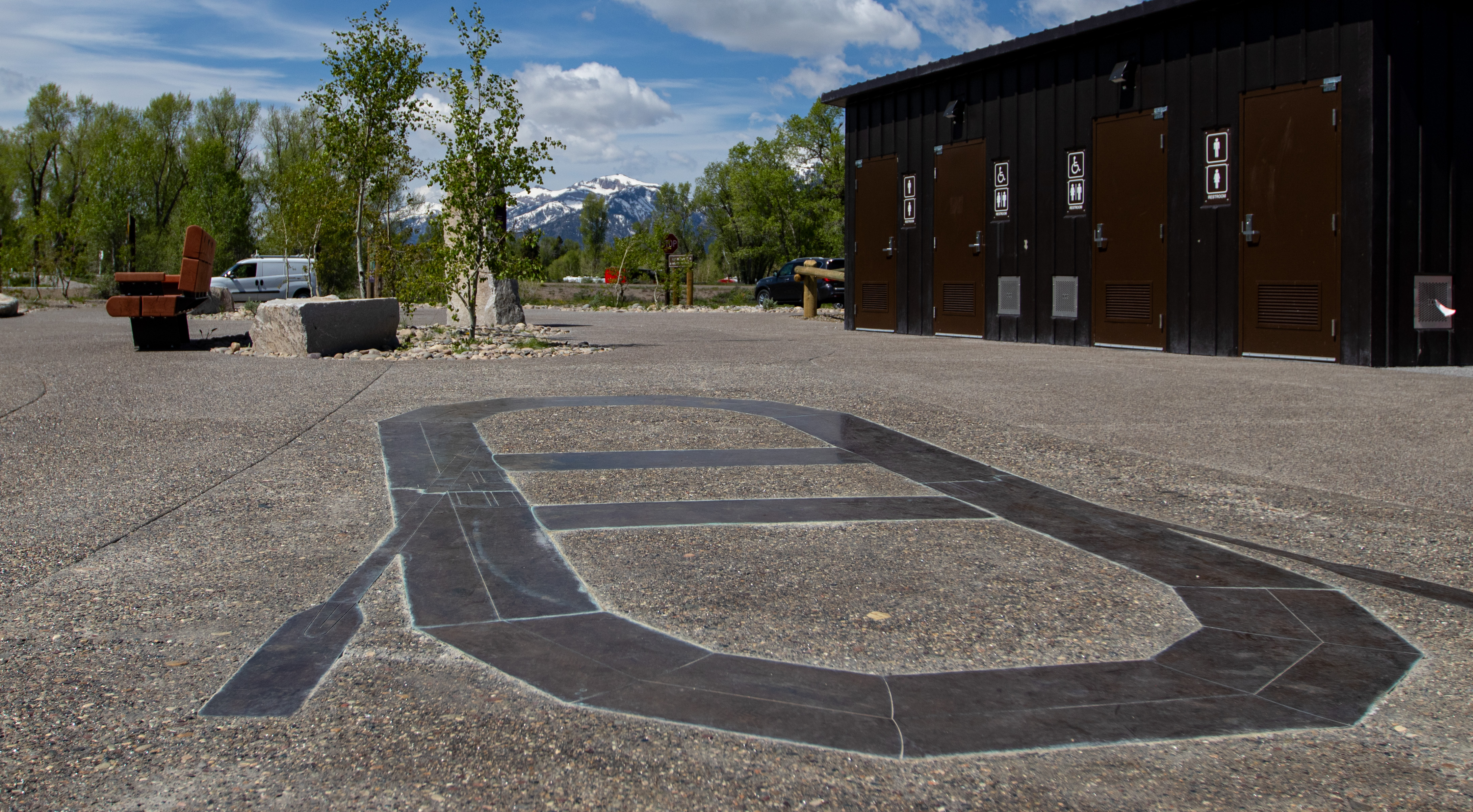
NPS via NPS.gov (Public Domain)
A Boat's Purpose: Snake River Exhibit, Grand Teton
6 min read
Places & Points of Interest
Plan your 2026 visit to A Boat's Purpose. Complete guide to trails, fees, lodging, best time to visit, and insider tips.
Your plans
Overview
The 'A Boat's Purpose' exhibit sits along the Snake River in Grand Teton National Park. It's not a destination in the traditional sense—no town, lake, or trailhead—but a place to reflect on how humans have interacted with this river for centuries. The display poses a straightforward question: why do we use boats? Your purpose on the water—whether for transport, fishing, or recreation—has always dictated the craft you choose. The site offers benches, historical context, and tactile elements, all fully accessible. Many visitors hurry past on their way to trails, but this stop grounds the valley's human story in a tangible way. Grasping a boat's purpose means understanding a core aspect of life in Jackson Hole.
Quick Information
- Entrance Fee: Access to this exhibit requires a Grand Teton National Park entrance pass. As of 2026, that's $35 per private vehicle for a 7-day pass. An annual park-specific pass is $70. The America the Beautiful Interagency Annual Pass ($80) also covers entry.
- Hours: The outdoor exhibit is accessible 24/7, but the best experience is during daylight hours. The park itself is open year-round, though many services are seasonal.
- Best Time to Visit: Late May through September. The exhibit is exposed, so pleasant weather makes the stop more enjoyable.
- Location: Grand Teton National Park, Wyoming. GPS coordinates: 43.65541126, -110.71570746.
- Accessibility: Fully wheelchair accessible, with benches and a tactile exhibit.
- Cell Service: Coverage in this area of the park is typically spotty. Don't rely on it for navigation.
- Restrooms: There are no dedicated restrooms at this specific exhibit. The nearest facilities are at other developed areas like visitor centers.
- Parking: There is a small, designated pullout area. It can fit perhaps 3-4 vehicles. If it's full, do not park on vegetation; move on and circle back.

Getting There
The exhibit is located along the main park road, US Highway 89/191/287, between the Craig Thomas Discovery & Visitor Center in Moose and the Moran Junction. From the Moose Junction, head north. The pullout will be on your right (east) side of the road, overlooking the Snake River floodplain. From Jackson, it's about a 20-minute drive north. From the south entrance of Yellowstone, it's roughly an hour's drive south. Rangers at the visitor center can point it out on a map. The key is to watch for the specific interpretive sign and pullout - it's easy to miss if you're focused on the mountain views.
What to Expect
Prepare for a quiet moment of reflection. Crowds and amenities are absent here. You'll find a flat, paved pullout leading to a low stone wall that overlooks the Snake River's braided channels and cottonwood stands. The view offers a horizontal contrast to the Tetons' vertical rise: a broad, grassy floodplain where the river catches the light. Listen for the wind in the cottonwoods and the river's distant murmur. The air carries the scent of dry sage and grass. Many first-timers are struck by how a basic question—why we use boats—ties together centuries of exploration, trade, and recreation in this valley. The exhibit shifts your perspective: the river isn't just scenery; it's a working waterway.

Top Attractions & Points of Interest
While this is a single exhibit, its value lies in connecting to the broader landscape. It serves as a lens for understanding the Snake River as you encounter it across the park.
The Exhibit Itself
The core attraction is the interpretive display. It uses text and likely tactile elements to contrast different boat types - dugout canoes, rafts, drift boats, kayaks - and their historical and modern purposes: transportation, fishing, guiding, recreation. The benches allow you to sit and watch the very river the exhibit describes. It's a five to fifteen-minute stop, max. The best time is mid-morning or late afternoon when the light is soft. Rangers will tell you this is a good spot for contemplation away from the busier overlooks.
Activities
The activity here is purely interpretive: reading, reflecting, and observing the river landscape. It serves as an excellent primer before engaging in the park's actual river-based activities. After pondering a boat's purpose, you might better appreciate a scenic float trip or the sight of a guide maneuvering a drift boat. It's also a convenient, quick stop to break up a scenic drive. For those planning more active pursuits, our guide to tours and guided experiences covers the various ways to get on the water.

Seasonal Guide
The exhibit is an outdoor installation, so its accessibility is entirely weather-dependent.
- Winter (Dec-Mar): The pullout may be snow-covered and not plowed. Access is difficult and not recommended.
- Spring (Apr-May): The road is open, but conditions can be muddy. This is when the river runs high with snowmelt, a powerful sight that underscores the need for sturdy craft.
- Summer (Jun-Aug): Fully accessible. Early morning or evening visits offer cooler temperatures and fewer passing cars.
- Fall (Sep-Oct): An excellent time. Crowds thin, the cottonwoods turn gold, and the exhibit is pleasant in the crisp air.
Practical Information
No permits or reservations are needed for this stop. It's free beyond the park entrance fee. There are no camping, lodging, or dining facilities on-site. The closest services for gas, food, and lodging and accommodations are in Moose or at the park lodges. The Craig Thomas Discovery & Visitor Center in Moose is your best bet for restrooms, water, and additional information. As of 2026, be aware of parkwide construction; this exhibit is unlikely to be affected, but travel delays on the main road are possible.

Safety & Preparation
This is a very low-risk location. Primary safety considerations are traffic-related: use turn signals when pulling into and out of the pullout, and watch for cyclists on the main road. There are no guardrails separating the exhibit area from the riverbank slope, so supervise children closely. Wildlife, like moose, can frequent the river corridor; give them ample space. Bring your own water, as none is available here. For backcountry river safety, you'd need to consult with park rangers.
Insider Tips
- Pair it with a Drive: This stop makes the most sense as part of the park's scenic drive. Hit it on your way north to Colter Bay or south to Moose.
- Photography Angle: For photographers, the best shot isn't of the sign, but of the river from the overlook, with the textured foreground of the exhibit elements.
- What the Website Doesn't Mention: The tactile component is designed for accessibility, but everyone benefits from touching the different materials meant to represent various boat hulls.
- Parking Protocol: If the small pullout is full, do not create your own parking spot. The vegetation is fragile. Proceed to the next turnout and double back in a few minutes.
- Context is Key: Read the exhibit before you look at the river. It will change what you see, helping you spot river features and maybe even boats you'd have missed.
- Quiet Time: This is one of the quieter interpretive stops in the park. If you need a moment of calm away from the popular lake overlooks, this is it.
- Link to History: After visiting, the historic ranches and homesteads you'll see, like those on Mormon Row, make more sense. The river was their lifeline.
For a complete a boat's purpose guide to the park, from hiking trails to wildlife viewing and camping options, explore our dedicated resources.
For more information, see our complete Grand Teton National Park Guide.
Sources
- Official source: NPS — Grand Teton National Park nps.gov/grte/index.htm
- Official source: National Park Service nps.gov/places/a-boat-s-purpose.htm
Photo Gallery
More to Explore

Park Guide
Acadia National Park: Carriage Roads, Cadillac Mountain & 2026 Guide
Discover carriage roads, Cadillac Mountain, and rugged Maine coast. Complete 2026 guide to Acadia National Park — trails, fees, lodging, permits, and what rangers recommend.

Hiking Guide
Grand Canyon Hiking Trails: Day Hikes, Water Sources & Rim to Rim
Compare Grand Canyon hiking trails: Bright Angel, South Kaibab, Hermit, Grandview, and rim to rim, with distances, elevation, water stops, and trailhead access for each.

Best Of
Best of Glacier Bay National Park
The best of Glacier Bay is reached by boat: ranger-led day tours up the bay to the tidewater glaciers. What's worth it, how to book, and when to go (2026).

Campsite Guide
White Sands Backcountry Camping: Closed for 2026 — What to Know
As of 2026, backcountry camping at White Sands National Park is closed for site rehabilitation. What that means, and where to camp nearby instead.

Weather Guide
Guadalupe Mountains National Park Weather: Weather
Guadalupe Mountains National Park: weather guide guide updated 2026. Practical visitor information, reservations, and seasonal tips worth bookmarking before

Best Of
Best of Cuyahoga Valley National Park: Best Things to Do
Seeing a Cleveland Orchestra concert with the woods as your backdrop is a uniquely Cuyahoga Valley experience.
Sign in to join the conversation.
Sources & Attribution
Location data courtesy of the National Park Service (U.S. Department of the Interior). NPS data is public domain. Official NPS page.
Images: NPS; NPS; NPS; NPS; NPS.
Map data © OpenStreetMap contributors.
Park operations alerts: NPS.gov · Weather and weather hazards: National Weather Service · Live conditions.
Information may change. Always verify fees, hours, and conditions directly with the official source before visiting.
Did this guide help? Share it with a friend.