Gravel crunches underfoot, a sound amplified by the thin, cool air. You'll likely look west to find a wall of cloud obscuring the horizon beyond the first line of hills. That's the typical first impression of Denali. While defined by a single, staggering mountain, the peak is visible less than a third of the time. The park's six million acres of wilderness—taiga forest, braided rivers, alpine tundra—don't require a clear day to show their character. Solitude, quiet, and wildlife on their own terms are the constants. The mountain is the exclamation point, but the story is told in wind, gravel, and the distant bark of a fox. This guide covers navigating a park with one road, unpredictable weather, and a scale that demands careful planning.
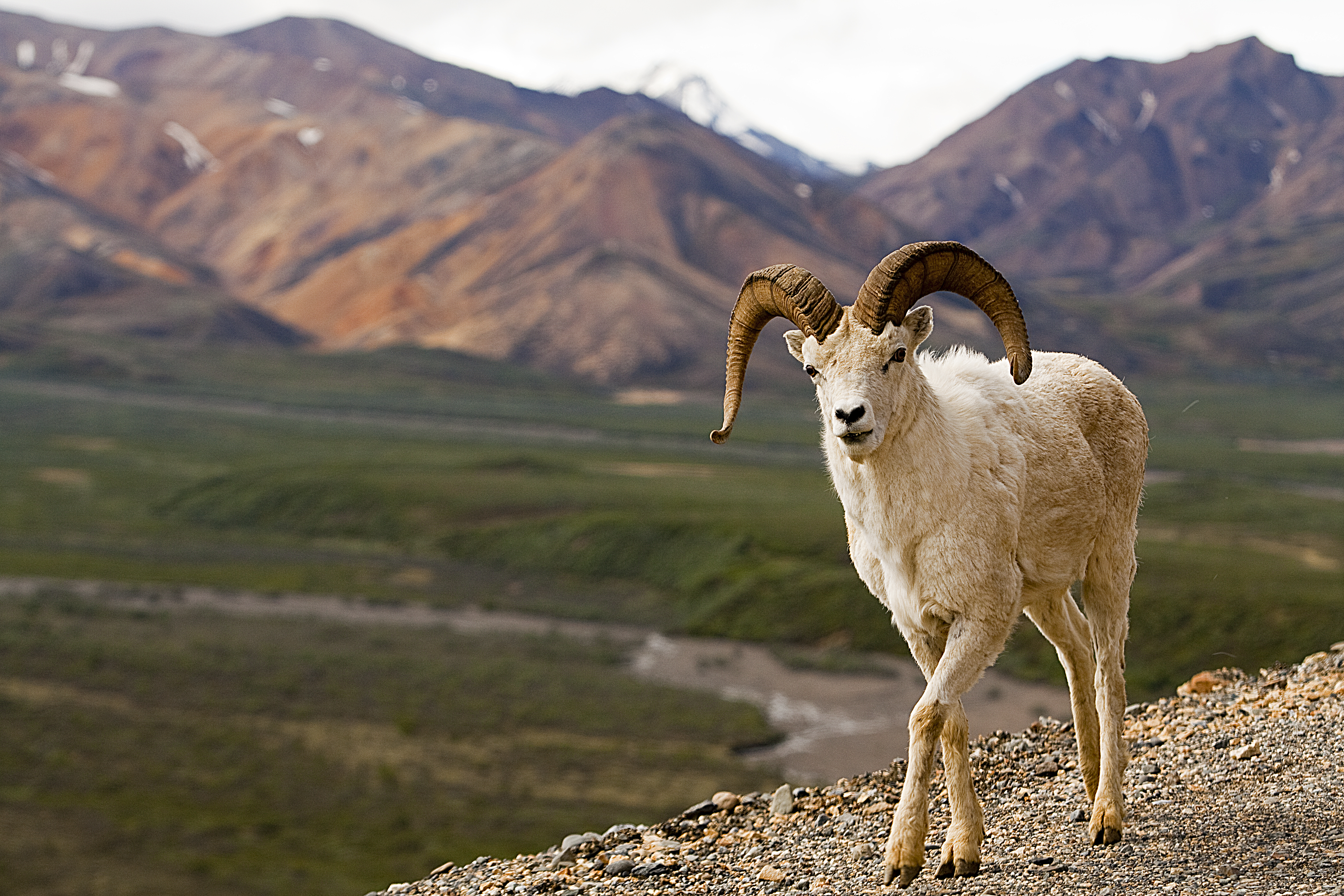
NPS via NPS.gov (Public Domain)
Denali National Park: North America's Highest Peak - 2026 Visitor Guide
9 min read
Park Guide
Denali National Park centers on a single park road into Alaska Range tundra and wildlife habitat, where mountain views depend on weather and road access from the entrance.
Your plans
This article contains affiliate links — we may earn a small commission at no extra cost to you.
At a glance
Entrance Fee
Per person $15Full fee schedule
Hours
Denali is open 24-hours a day, although services are limited after-hours (generally after 4 pm in wi
Best Time
June-September (summer), September-October (fall colors)
Address
Mile 237 Highway 3, Denali Park, AK, 99755
Website
63.2978, -151.0527
Google MapsThe Lay of the Land: One Road, Six Million Acres
Denali operates on a simple, non-negotiable rule. There is one road. It runs 92 miles from the park entrance to the old mining settlement of Kantishna. For the vast majority of visitors, private vehicle travel ends at Mile 15, the Savage River bridge. Beyond that, the ribbon of pavement belongs to park buses, bicycles, and the occasional researcher's vehicle. This isn't a traffic control measure; it's a wilderness preservation mandate. The road was engineered to follow the contours of the land, not dominate it. The result is a journey where you are a passenger in every sense, watching a landscape unfold at 25 miles per hour.
The critical factor shaping your visit as of 2026 is the Pretty Rocks Landslide at Mile 45.5. This active, moving slope of rock and ice has forced a long-term closure of the park road at Mile 43. The famed Eielson Visitor Center at Mile 66 and the Wonder Lake area are inaccessible by road. Transit buses now turn around at the East Fork River (Mile 43), and the park is engineering a permanent solution. This changes the calculus for a trip. You won't reach the traditional deep-park vistas, but the journey to Polychrome Overlook remains, and the wildlife doesn't know the road is closed.
Most first-time visitors are caught off guard by the distances. A "short" bus trip to the Teklanika River Rest Area (Mile 30) is a six-hour round-trip commitment from the visitor center. You move slowly, stop for wildlife, and let oncoming buses pass on narrow stretches. Rangers will tell you that the bus ride isn't just transportation; it's the core activity. You trade control for immersion. Cell service drops out for good about two miles past the entrance, and the outside world fades into the static of a bus radio scanning for bear reports.

Getting There and Getting Started
Access is by road or rail. Drive from Anchorage (about 5 hours south) or Fairbanks (about 2 hours north) on the George Parks Highway (AK-3). The Alaska Railroad from either city stops at the Denali Depot right at the park entrance. No shuttle service operates from nearby towns; your options are driving, taking the train, or booking a packaged tour with included transport.
The park is open 24 hours a day, but the Denali Visitor Center - your hub for bus tickets, the park film, exhibits, and the all-important backcountry office - operates on a summer schedule, typically from mid-May to mid-September. As of 2026, the entrance fee is $15 per person, aged 16 and older, and is valid for seven days. You pay this at the visitor center. Keep your receipt. Rangers do check.
Parking becomes a study in controlled chaos from 8 AM to noon. The main lot by the visitor center fills quickly. Seasoned visitors head for the overflow lot near Riley Creek Campground instead.d walk the paved path about 10 minutes to the visitor center. It's easier. The Denali Bus Depot, operated by the park concessionaire, is where you actually board buses. It's a separate building a short walk from the main visitor center. This is where confusion happens: you get your backcountry permit at the visitor center, but you pick up your reserved bus tickets at the depot. Give yourself at least 45 minutes between arriving at the park and needing to catch a bus.
For a complete breakdown of where to stay, from campgrounds to lodges, see our guide to lodging and accommodations.

Choosing Your Ride: Buses, Bikes, and Boots
Your access to the park hinges on a choice of wheels. There are two main bus types: Transit and Tour. The difference is not trivial.
Denali Transit Buses are the workhorses. They are school-bus style, non-narrated, and function as a hop-on, hop-off backcountry shuttle. You can get off anywhere, hike, and flag down a later bus (space permitting) to continue or return. This is the only way to access trail-less terrain for day hiking or to reach a backcountry unit for overnight trips. The ride is quiet, punctuated by the driver pointing out a distant bear or stopping for a caribou herd near the road. The round-trip to the East Fork turnaround (Mile 43) takes most of a day. Bring all your own food, water, and layers.
Denali Tour Buses are narrated, have more comfortable seating, and include a box lunch. They do not allow hop-on, hop-off privileges; you stay with your assigned bus the entire route. The narration covers natural and human history. It's a good choice if your priority is a guided, sit-back experience with guaranteed commentary. Both bus types are essential for wildlife viewing, as the drivers communicate animal sightings to each other.
Biking the Park Road is a brilliant alternative for the fit and prepared. You can ride past the private vehicle checkpoint at Savage River and have the pavement largely to yourself, especially early in the morning before bus traffic picks up. The classic move is to take a transit bus deep into the park with your bike, then ride out. This gives you a downhill advantage with the overall elevation loss from west to east. The road surface is good, but there are no shoulders. You share the road with full-size buses. It's not for the nervous.
Finally, there are the guided tours offered by authorized concessionaires, which range from flightseeing and glacier landings to natural history walks near the entrance area.

The Hiking Reality: Trails vs. Trail-less Tundra
Denali has a handful of maintained trails, all clustered near the park entrance. The Horseshoe Lake Trail, the Mount Healy Overlook Trail, and the paths around the Savage River area are well-trodden and offer great introductory views. Early morning is your best bet for quiet on these trails, especially the popular hike to Horseshoe Lake.
But the real hiking in Denali begins where the trails end. Off-trail travel is not just permitted; it's the default mode for exploring 99% of the park. This is a fundamental shift from most national park experiences. There is no worn path to follow, no sign pointing to a scenic overlook. You navigate by map, compass, and land features. The tundra is spongy and hummocky - what rangers call "tussock hopping" - and it is slow, arduous work. One mile off-trail can take an hour.
This is why the transit bus system is so critical. You use it to get dropped off at a drainage or a ridgeline that calls to you. You spend the day exploring a creek bed, climbing a knob for a view, or traversing a valley. Then you flag down a bus to return. It requires more planning, more self-reliance, and a comfort with true solitude. For a detailed look at route ideas and preparation, our guide to hiking trails covers both the front-country and backcountry approaches.
Backpacking here is a serious undertaking. You need a free permit from the Backcountry Office, which involves watching a safety video and securing a specific unit. Units have quotas, and popular ones like the Toklat River area can be booked weeks in advance in peak season. You must be proficient in bear-safe food storage (bear-resistant canisters are provided) and river crossing techniques. The reward is a wilderness experience few other parks can still offer.

Seasons and Sensible Expectations
Denali's weather defies easy summary. Summer highs typically linger in the 50s and low 60s Fahrenheit. Lows dip into the 40s. Rain is frequent. The phrase "be prepared for chilly weather even in summer" on the park website is an understatement. Pack extra water for this stretch? No. Pack extra layers - a rain jacket, fleece, hat, and gloves - even in July. Cotton kills here, and that's not hyperbole.
The mountain makes its own weather. Clouds can boil up from the south in minutes, swallowing ridges and bringing a cold, driving rain. Conversely, a gray morning can burn off by noon to reveal a sky so clear the Alaska Range seems close enough to touch. You must pack for all of it, every single day.
Winter generally locks in by mid-September. By January, temperatures of -40°F are common. This is a different park: silent, stark, and accessible only by ski, snowshoe, or dog sled. The road is plowed to Mile 3 (Park Headquarters) for vehicle access to the sled dog kennels. For a deeper analysis of conditions month-by-month, check our guide on the best time to visit.
Fall is short and spectacular. Tundra plants turn crimson and gold in late August, while the valleys follow with yellow aspens in September. Crowds thin, but services begin to shutter after Labor Day. Spring is a muddy, transitional period in April and May as the snow melts.
Most visitors underestimate the cold. They show up in shorts and a hoodie, then spend $80 on a sweatshirt at the park store. Don't be that person. Dress like you're going on a shoulder-season hike in the Rockies, even if the calendar says August.
Practical Takeaways
- Book Bus Tickets Early. Transit and tour bus seats for July and August can sell out weeks, sometimes months, in advance. Reserve online as soon as your travel dates are firm. Hop-on, hop-off space on transit buses is first-come, first-served on the day of travel, so board early if you plan to get off and on multiple times.
- Pack for Four Seasons in One Day. Your daypack must include: a waterproof rain shell, an insulating fleece or puffy jacket, a warm hat, gloves, sturdy waterproof boots, rain pants (trust us), sunscreen, sunglasses, and all your food and water. There are no services beyond the visitor center.
- Manage Your Wildlife Expectations. You will likely see caribou and Dall sheep. Seeing a grizzly bear or wolf is a matter of luck, patience, and distance. Use binoculars or a spotting scope. Never approach wildlife. The rule is to stay at least 300 yards from bears and 25 yards from all other animals.
- Embrace the Transit Bus for Hiking. Don't just ride to the turnaround and back. Study the park map, pick a creek or ridge between mileposts that looks interesting, and ask the driver to let you off. Have a plan for where you'll meet the road later to flag down a return bus.
- Secure Camping and Backcountry Permits Ahead. For camping options in the front-country campgrounds like Savage River or Teklanika River, reservations are essential. For backpacking, visit the Backcountry Office in person the day before your trip to get your permit and bear canister. Popular units go fast.
- Check the Road Status Daily. The Pretty Rocks Landslide situation is fluid. While the Mile 43 closure is stable as of 2026, always verify current conditions, bus turn-around points, and campground accessibility on the official park website before you finalize plans.
Final Thoughts
Denali National Park resists the checklist mentality. You don't "do" Denali by hitting a series of iconic viewpoints. You experience it by surrendering to its pace and its rules. The journey on the bus, the effort of walking across tussock tundra, the long wait for a mountain that may never appear - these aren't obstacles to the experience. They are the experience.
The common mistake is to come seeking only the postcard of the great peak. What you find instead is the immense, quiet country that cradles it. You leave with the grit of glacial silt in your boot seams, the memory of a caribou's clicking ankles, and the understanding that wilderness isn't just a view. It's a condition of travel. The mountain, if it shows itself, becomes a gift. But the gift is already there, in every silent mile between the spruce trees.
Recommended Gear
What experienced visitors bring to Denali National Park: North America's Highest Peak - 2026 Visitor Guide
Links may earn us a commission at no extra cost to you. We only recommend gear we believe in.
Hiking Essentials
Hydration Pack (3L)
Hands-free water for long trail days
Trekking Poles (Pair)
Save your knees on steep descents
Hiking Boots (Ankle Support)
Sturdy footwear for rocky, uneven trails
Sun & Heat Protection
Wide-Brim Sun Hat
Full coverage UPF 50+ protection at altitude
Insulated Water Bottle (32oz)
Keeps water cold in desert heat all day
Electrolyte Mix Packets
Replace what water alone cannot during intense heat
Winter Gear
Microspikes / Traction Devices
Essential for icy rim trails in winter months
Packable Down Jacket
Lightweight warmth that stuffs into a pocket
Sources
- Official source: NPS — Denali National Park nps.gov/dena/index.htm
Explore More National Parks

Lake Clark National Park: Wild Alaska by Floatplane - 2026 Visitor Guide
Discover Lake Clark National Park national park guide with our comprehensive guide. Expert tips, pra...

Kenai Fjords National Park: Tidewater Glaciers & Marine Wildlife — 2026 Guide
Discover kenai fjords national park how to get there with our comprehensive guide. Expert tips, prac...

Wrangell-St. Elias National Park: 13.2 Million Acres (2026)
2 million acres, it's the largest unit in the national park system—a statistic that only makes sense...

Gates of the Arctic National Park: Complete Guide (2026)
Gates of the Arctic National Park, America's northernmost park, has no roads or trails. Reach it by...
Photo Gallery
More to Explore

Park Guide
Acadia National Park: Carriage Roads, Cadillac Mountain & 2026 Guide
Discover carriage roads, Cadillac Mountain, and rugged Maine coast. Complete 2026 guide to Acadia National Park — trails, fees, lodging, permits, and what rangers recommend.

Hiking Guide
Grand Canyon Hiking Trails: Day Hikes, Water Sources & Rim to Rim
Compare Grand Canyon hiking trails: Bright Angel, South Kaibab, Hermit, Grandview, and rim to rim, with distances, elevation, water stops, and trailhead access for each.

Best Of
Best of Glacier Bay National Park
The best of Glacier Bay is reached by boat: ranger-led day tours up the bay to the tidewater glaciers. What's worth it, how to book, and when to go (2026).

Campsite Guide
White Sands Backcountry Camping: Closed for 2026 — What to Know
As of 2026, backcountry camping at White Sands National Park is closed for site rehabilitation. What that means, and where to camp nearby instead.

Weather Guide
Guadalupe Mountains National Park Weather: Weather
Guadalupe Mountains National Park: weather guide guide updated 2026. Practical visitor information, reservations, and seasonal tips worth bookmarking before

Best Of
Best of Cuyahoga Valley National Park: Best Things to Do
Seeing a Cleveland Orchestra concert with the woods as your backdrop is a uniquely Cuyahoga Valley experience.
Sign in to join the conversation.
Sources & Attribution
Location data courtesy of the National Park Service (U.S. Department of the Interior). NPS data is public domain. Official NPS page.
Images: NPS; NPS; NPS; NPS; NPS.
Map data © OpenStreetMap contributors.
Park operations alerts: NPS.gov · Weather and weather hazards: National Weather Service · Live conditions.
Information may change. Always verify fees, hours, and conditions directly with the official source before visiting.
Did this guide help? Share it with a friend.