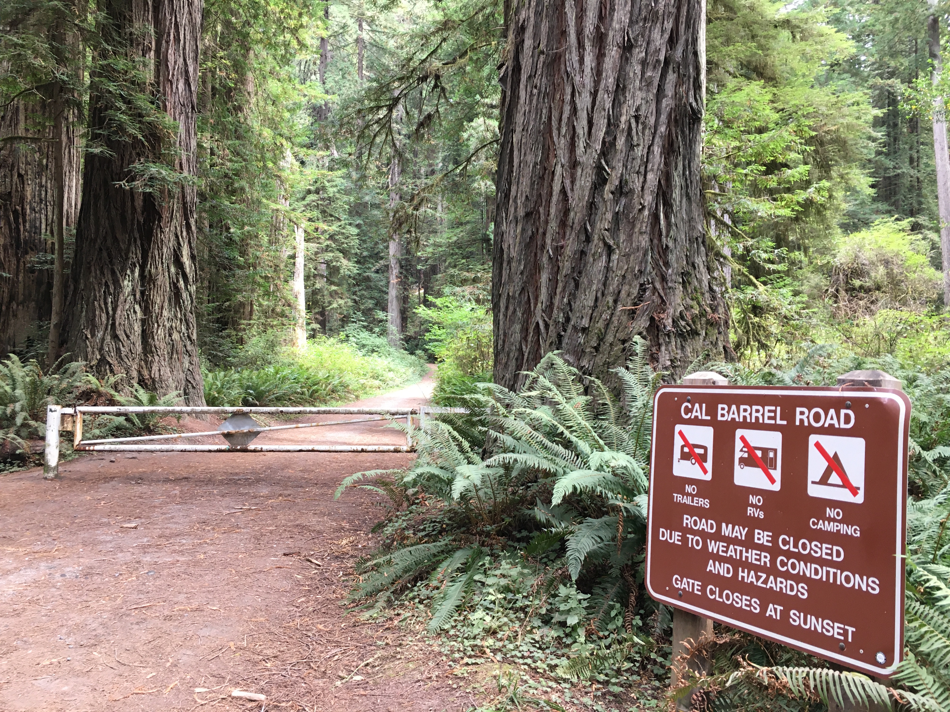
Cal Barrel Road is a three-mile dirt track that ascends through old-growth redwood groves. Most of the year, a closed gate restricts vehicle access, making it a quiet path for walkers, cyclists, and leashed dogs. The route offers a steady cardio climb and provides some of the most immediate access to massive trees in the southern reaches of Redwood National and State Parks. Here's what you should know for a 2026 visit.
NPS via NPS.gov (Public Domain)
Cal Barrel Road: Complete 2026 Visitor Guide
9 min read
Places & Points of Interest
Plan your 2026 visit to Cal Barrel Road. Complete guide to trails, fees, lodging, best time to visit, and insider tips.
Your plans
Overview
Built as a 3.5-mile logging road in another era, Cal Barrel Road now functions as a distinct recreational corridor. The grade remains steady, the surface is packed dirt and gravel, and the redwoods themselves command attention. You won't find interpretive signage or formal trailheads here. The experience centers on moving through the forest along this broad path, where the trees offer their own silent narrative. It's among the few areas in the park complex where you can reliably take a leashed dog for a substantial walk without contending with narrow, root-choked single-track. The gate is usually closed to vehicles, maintaining a quiet, safe environment for non-motorized use. Cell service fades at the trailhead, so prepare for that.
Quick Information
* Entrance Fee: There is no fee to access Cal Barrel Road itself. However, it is located within Redwood National and State Parks. As of 2026, there are no park entrance fees, but developed campgrounds and some reserved activities have costs.
* Hours: Accessible year-round, 24 hours a day. The gate is typically closed to vehicles.
* Best Time to Visit: Late spring through early fall (May to October) for the driest road conditions. Winter visits are possible but expect mud and more frequent rain.
* Location: Northern California, within Prairie Creek Redwoods State Park. Nearest services are in Orick, about a 15-minute drive south. GPS coordinates: 41.3654, -124.0181.
* Accessibility: The road is a wide, compacted gravel surface with a steady grade. It is not ADA-compliant due to the incline and surface material, but it is navigable with robust all-terrain wheelchairs or strollers with assistance.
* Cell Service: Unreliable to nonexistent.
* Restrooms: None at the Cal Barrel Road entrance. The nearest vault toilets are at the Elk Prairie Day Use Area or the Prairie Creek Visitor Center.
* Parking: A small, unmarked pullout area exists near the gate. It can fit about 4-5 vehicles. If full, do not park on the road or vegetation. Use the larger Elk Meadow Day Use Area parking lot and walk the short distance along the road to the gate.

Getting There
Cal Barrel Road lies just off the Newton B. Drury Scenic Parkway. From Highway 101 near Orick, take the exit for the Newton B. Drury Scenic Parkway—it's marked as the scenic alternative. Head north on the parkway for about 2.5 miles. You'll pass the Prairie Creek Visitor Center on your left. Continue another half-mile and watch closely on your right for a modest gravel road with a closed gate. A small pullout sits on the left (west) side of the parkway, directly across from the gate. The turn is inconspicuous and easy to overlook. If you arrive at the Elk Meadow Day Use Area, you've overshot by roughly a quarter-mile.
From Crescent City, drive south on Highway 101 for about 40 minutes, then take the Newton B. Drury Scenic Parkway exit. Follow the parkway south for roughly 8 miles; the Cal Barrel Road gate will be on your left, just before you reach the Elk Meadow area.
The parking situation here is first-come, first-served. The pullout fills quickly on summer weekends. Your best bet is to park at the much larger Elk Meadow Day Use Area lot, which also serves as a hub for several other hiking trails. It's a short, flat walk along the parkway shoulder to reach the Cal Barrel Road gate.
What to Expect
Expect a steady, moderate climb on a wide roadbed. The surface is hard-packed gravel and dirt, which can develop shallow potholes and puddles after rain. The grade is consistent - not brutally steep, but you'll feel it in your legs, especially on the return trip. This isn't a meandering nature trail; it's a former logging road, so the path is direct and purposeful.
The forest here is classic old-growth: a mix of towering coast redwoods, Douglas-fir, and bigleaf maple. In fall, the maple leaves turn bright yellow and litter the road with color. The understory is dense with redwood sorrel, ferns, and huckleberry. The soundscape is dominated by wind high in the canopy, the occasional croak of a raven, and the crunch of gravel underfoot. On foggy days, which are common, moisture drips from the branches, and the tree trunks appear to fade into the gray. On sunny days, shafts of light cut through the canopy, highlighting the rust-red bark and green undergrowth.
Most first-time visitors are caught off guard by the sheer width of the road - it feels like walking through a green cathedral with a nave the width of a two-lane street. The common mistake is underestimating the workout. A three-mile climb, followed by a three-mile return, is a real hike. Bring water. You won't find any facilities or benches along the way.

Top Attractions & Points of Interest
The attraction is the road itself and the grove it traverses. However, a few specific moments stand out.
The Initial Grove
About a quarter-mile in, the road enters a particularly dense stand of redwoods. The trees here are close to the road edge, and their size becomes immediately apparent. This is where most people stop for their first photos. The bark has a deep, fibrous texture you can see clearly from the path.
Mid-Point Clearing
Roughly 1.5 miles up, the road passes a subtle clearing where sunlight reaches the ground more fully. In spring and summer, this spot has a different floral character than the deep-shade sections. It's a good place to catch your breath and notice the change in plant life.
Upper Terminus
The road ends at a gated junction with an old logging spur. There's no grand vista, just a quiet spot deep in the woods. The return trip is all downhill from here. Experienced visitors know to take a few minutes here to listen - it's often the quietest point, with only the sound of your own breathing and the distant wind.
Activities
Hiking and Walking
This is the primary use. Treat it as a 6-mile out-and-back hike. Wear sturdy shoes - the gravel can be uneven. The steady incline makes it a good fitness walk. There are no side trails, so navigation is impossible to get wrong.
Cycling
Cal Barrel Road is a popular, if challenging, mountain bike route. The wide roadbed accommodates bikes easily, and the climb is a respected local workout. The descent is fast and fun, but control your speed; the gravel surface can be loose, and you may encounter hikers and dogs around blind corners. A bicycle rack is present at the parking pullout.
Dog Walking
This is one of the best places in the parks to walk a leashed dog. The wide road allows room to pass others safely, and the surface is easier on paws than rocky trails. Rangers will tell you to keep your pet leashed at all times - this is for their safety and the protection of wildlife.
Photography
The linear perspective of the road creates natural leading lines for photos. Early morning is your best bet for soft light filtering through the trees. The fog, common before noon, adds atmosphere. Focus on textures: the rough bark, the smooth road surface, the delicate sorrel leaves.
Wildlife Viewing
You're less likely to see large mammals here than in the open prairies, but the forest is full of life. Keep an eye out for varied thrushes on the road, pileated woodpeckers on snags, and banana slugs on damp mornings. For dedicated wildlife viewing, the elk meadows are more reliable.

Seasonal Guide
* Spring (April-June): The best balance. Days are longer, rain tapers off, and the understory is lush and green. Afternoon temperatures range from 50-65°F. The road dries out from winter rains.
* Summer (July-September): The most popular and driest season. Daytime highs can reach 70-75°F in the sun, but the forest floor remains cool. Mornings often start with fog that burns off by late morning. This is when the small parking pullout fills fastest.
* Fall (October-November): A quiet favorite. Crowds diminish, the bigleaf maples turn brilliant yellow, and the first rains settle the dust. Temperatures drop to 45-60°F. The road can become muddy after storms.
* Winter (December-March): For solitude. Expect near-constant dampness, mud, and the possibility of downed branches. Temperatures range from 40-55°F. The road is passable with waterproof boots, but the experience is for those who don't mind getting wet. Check for storm-related closures before you go.
For a detailed breakdown of conditions, see our guide on the best time to visit.
Practical Information
No permits or reservations are needed to walk, bike, or run Cal Barrel Road. It's a free activity.
The nearest lodging and accommodations are in the towns of Orick (limited), Trinidad, and Crescent City. For those wanting to stay in the park, consider the camping options at nearby Elk Prairie Campground or Mill Creek Campground, both $35 per night as of 2026.
Gas and basic supplies are available in Orick. More comprehensive services, including grocery stores and restaurants, are in Trinidad (30 minutes south) or Crescent City (40 minutes north). There are no water fill stations or food for sale at the Cal Barrel Road access point.

Safety & Preparation
* Footwear: Wear closed-toe shoes with good traction. The gravel can be slippery when dry and muddy when wet.
* Water: There is no drinking water. Pack all you'll need for a 6-mile round trip with elevation gain.
* Weather: Coastal forests are damp. Bring a rain layer, even if the sky looks clear. Temperatures under the canopy can be 10-15 degrees cooler than in open areas.
* Wildlife: While unlikely, black bears and mountain lions inhabit these forests. Make noise while traveling, keep dogs leashed, and know how to react. Never approach elk.
* Emergency: Cell service is absent. The nearest ranger station is at the Prairie Creek Visitor Center. In an emergency, you must send someone to get help.
* Road Sharing: Cyclists yield to all pedestrians. Everyone yields to horses (though equestrian use here is very rare). Announce yourself when passing from behind.
Insider Tips
- The Gate is Your Friend. The closed gate is what keeps Cal Barrel Road peaceful. If you find it open (rare), be extra vigilant for vehicle traffic.
- Skip the Pullout. Just drive past the small Cal Barrel Road pullout and park at Elk Meadow Day Use Area. You'll have a guaranteed spot and a trivial 5-minute walk to the gate.
- Reverse Your Hike. For a different perspective, consider walking the road from top to bottom. You'll need a shuttle or bike drop, but starting at the upper gate (accessible via a different service road) gives you a gentle downhill walk through the grove.
- Post-Rain Visit. The road surface is firmest and the colors are most vibrant a day or two after a rain, once the worst mud has settled.
- Combine with a Scenic Drive. Make this part of a longer outing on the Newton B. Drury Scenic Parkway. Do your hike or bike ride, then drive the rest of the parkway slowly, stopping at the Big Tree Wayside.
- Early Beats Late. If you want solitude, go early. By 10 AM on a summer weekend, you'll share the road with other hikers, runners, and cyclists. At dawn, you might have it to yourself.
- Check for Tours. While not a typical tour destination, some local guiding companies incorporate Cal Barrel Road into custom tours and guided experiences focused on forest ecology or photography.
Links may earn us a commission at no extra cost to you. We only recommend gear we believe in. For this road, traction is key - consider a pair of hiking shoes with a solid Vibram sole. A small hydration bladder is more convenient than water bottles for the steady climb. And always pack a lightweight, packable rain jacket. The drizzle here is rarely heavy, but it's persistent.
For more information, see our complete Redwood National Park Guide.
Sources
- Official source: NPS — Redwood National Park nps.gov/redw/index.htm
- Official source: National Park Service nps.gov/places/calbarrelrd.htm
Photo Gallery
More to Explore

Park Guide
Acadia National Park: Carriage Roads, Cadillac Mountain & 2026 Guide
Discover carriage roads, Cadillac Mountain, and rugged Maine coast. Complete 2026 guide to Acadia National Park — trails, fees, lodging, permits, and what rangers recommend.

Hiking Guide
Grand Canyon Hiking Trails: Day Hikes, Water Sources & Rim to Rim
Compare Grand Canyon hiking trails: Bright Angel, South Kaibab, Hermit, Grandview, and rim to rim, with distances, elevation, water stops, and trailhead access for each.

Best Of
Best of Glacier Bay National Park
The best of Glacier Bay is reached by boat: ranger-led day tours up the bay to the tidewater glaciers. What's worth it, how to book, and when to go (2026).

Campsite Guide
White Sands Backcountry Camping: Closed for 2026 — What to Know
As of 2026, backcountry camping at White Sands National Park is closed for site rehabilitation. What that means, and where to camp nearby instead.

Weather Guide
Guadalupe Mountains National Park Weather: Weather
Guadalupe Mountains National Park: weather guide guide updated 2026. Practical visitor information, reservations, and seasonal tips worth bookmarking before

Best Of
Best of Cuyahoga Valley National Park: Best Things to Do
Seeing a Cleveland Orchestra concert with the woods as your backdrop is a uniquely Cuyahoga Valley experience.
Sign in to join the conversation.
Sources & Attribution
Location data courtesy of the National Park Service (U.S. Department of the Interior). NPS data is public domain. Official NPS page.
Images: NPS; NPS; NPS; NPS; NPS.
Map data © OpenStreetMap contributors.
Park operations alerts: NPS.gov · Weather and weather hazards: National Weather Service · Live conditions.
Information may change. Always verify fees, hours, and conditions directly with the official source before visiting.
Did this guide help? Share it with a friend.