A successful backcountry trip in Grand Teton National Park starts with a permit, not a trailhead. Secure yours via advance online reservation ($45) or walk-up at the Craig Thomas Discovery & Visitor Center ($35).
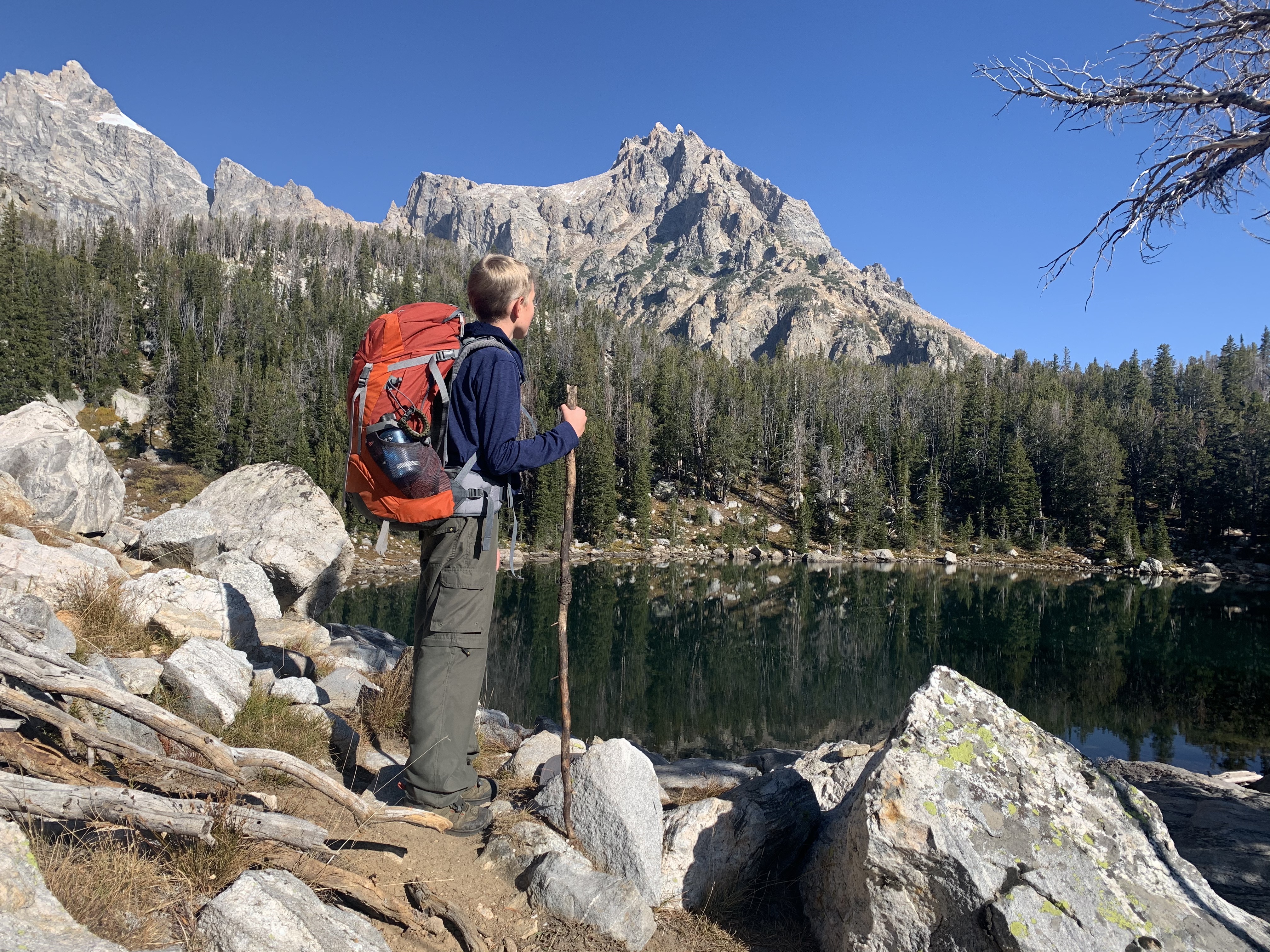
NPS via NPS.gov (Public Domain)
Backcountry Trip Planning
10 min read
Places & Points of Interest
Discover Backcountry Trip Planning: backcountry trip planning with our comprehensive guide. Expert tips, practical information, and insider knowledge.
Your plans
Overview
Planning a backcountry trip in Grand Teton requires navigating the National Park Service's formal permit system. This isn't about finding a place on a map—it's about securing approval for your wilderness itinerary through ranger stations or online portals. The park's backcountry spans over 200 miles of trails and dozens of camping zones, from Leigh Lake's forested shores to alpine terrain above 10,000 feet. You'll need to master the permit process, adhere to strict food storage protocols for bear safety, and prepare for weather that can turn from sunshine to snow in an afternoon. In my experience, the most frequent error isn't packing too little, but overestimating how far you can travel in steep, high-altitude country.
For walk-up permits, start at the Craig Thomas Discovery & Visitor Center in Moose. Rangers there will review your maps, go over bear safety protocols, and issue your camping permit. Since 2026, many permits have also been available through advance online reservation. This system manages human impact and maintains safety in terrain where assistance could be hours or days distant. Proper planning lays the groundwork for an experience built on self-reliance, deep silence, and vistas earned through steady climbing.
Quick Information
* Permit Fee: As of 2026, a backcountry camping permit costs $45 for advance reservation. A limited number of walk-up permits are available for $35. These are trip fees, not per-person fees.
* Hours: The backcountry permit office at the Craig Thomas Discovery & Visitor Center is typically open daily from 8 AM to 5 PM, with extended hours in peak summer. Advance reservations are handled online 24/7.
* Best Time to Plan: For summer trips, start planning and booking 6 months in advance when reservations open. For walk-up permits, arrive at the visitor center before it opens on the day you wish to start your trip.
* Location: The primary permit office is at the Craig Thomas Discovery & Visitor Center in Moose, Wyoming, just inside the park's south entrance.
* Accessibility: The visitor center is fully accessible. Backcountry trails and campsites themselves are primitive and not ADA-compliant.
* Cell Service: Unreliable to non-existent in the backcountry. Assume you will have none.
* Restrooms: Available at trailheads and visitor centers. In the backcountry, use designated facilities at some camping zones or practice Leave No Trace principles for waste.
* Parking: You must leave your vehicle at a designated trailhead parking lot. Overnight parking is allowed, but secure all valuables. Lots like String Lake and Death Canyon fill extremely early in summer.

Getting There
Begin your trip at the Craig Thomas Discovery & Visitor Center in Moose. From Jackson, take US-191 north for roughly 12 miles—the center sits on the right, just beyond the Moose Entrance Station. Coming from Yellowstone to the north, follow US-191/89/287 south for about 50 miles; you'll find the center on your left. Parking fills quickly by mid-morning, particularly for those seeking walk-up permits, so an early arrival is wise.
For those with advance reservations, you must still physically pick up your permit at the visitor center or another designated ranger station before your trip. You cannot print it at home. Allow at least 30-45 minutes for this process, as rangers will provide a mandatory briefing on current conditions, bear activity, and food storage regulations. Your chosen trailhead dictates where you'll finally park your car. Popular starting points like the String Lake Trailhead (for Paintbrush and Cascade Canyons) or the Death Canyon Trailhead require very early arrival to secure a spot, sometimes by 7 AM.
What to Expect
Expect a process. Successful backcountry trip planning means interacting with the park's permit system, which can feel bureaucratic but is designed for protection - of both the resource and you. The air in the permit office has a specific smell: a mix of pine-scented cleaner from the floors and the faint, dusty sweat of hikers who just came off the trail. You'll hear the rustle of topographic maps and the low murmur of rangers explaining camping zone boundaries to parties ahead of you.
Once on the trail, the environment dictates everything. Terrain transitions quickly from valley floor sagebrush to steep, rocky moraines. The sound of your own breath and the thwack of trekking poles on granite become the rhythm of the day. Afternoon thunderstorms are a near-daily possibility from July through August, rolling in with startling speed. Temperatures can plummet 30 degrees when the sun disappears behind the high peaks. Wildlife isn't just a possibility; it's a guarantee. You will see signs of bears. You are required to carry and use a park-approved bear-resistant food canister - no hanging food is allowed. The scale is deceptive; a mile on the map can take an hour when it gains 1,000 feet in elevation. Most first-time visitors are caught off guard by the sheer physicality of the hiking, even on so-called "moderate" trails.

Top Attractions & Points of Interest
While the backcountry itself is the attraction, your trip will revolve around specific corridors and destinations. These are not casual day hikes.
The Paintbrush-Cascade Canyon Loop
This is the park's signature 20-mile loop, a very strenuous route that climbs over 10,700-foot Paintbrush Divide. It's typically done as a 2-3 night trip. The park service recommends traveling counter-clockwise to tackle the steep, often snow-covered north side of Paintbrush Divide in the morning. Camping zones are limited and highly competitive. The view from Lake Solitude, a deep blue tarn carved by glaciers, is the reward for a brutal climb.
Death Canyon & the Static Peak Divide
Head into the steep, narrow confines of Death Canyon for a taste of the Tetons' rugged interior. The trail to the Static Peak Divide junction is a strenuous day or overnight hike. Those continuing to the Divide itself face a relentless, exposed climb, but are rewarded with a panoramic view into Idaho's Alaska Basin. The Phelps Lake Overlook at the canyon's mouth is a popular shorter hike, but the real solitude begins a few miles up the trail.
The Teton Crest Trail
This multi-day epic traverses the high alpine spine of the range, often incorporating sections of Paintbrush and Cascade Canyons with passes like Hurricane and Paintbrush Divides. It requires precise planning for camping zones and food caches, as resupply is not possible. Most parties spend 3-5 nights out. This is advanced backcountry trip planning, requiring confidence with route-finding and rapidly changing mountain weather.
Lake Solitude
A common destination for both day hikers from Jenny Lake and backcountry campers on the loop. By late afternoon, the day-hiker crowds thin, and the lake takes on a profound quiet. Camping zones are nearby but not on the immediate shore. The water is frigid, even in August, and the surrounding cliffs echo with the calls of pikas.
Granite Canyon & Marion Lake
Starting from the Teton Village area (permits required), this route offers a southern entrance into the high country. The hike to Marion Lake is very strenuous, climbing through forests and meadows into a rocky cirque. It sees fewer people than the canyons accessed from Jenny Lake. Be aware of the Moose-Wilson Road closure status, as it affects access to the Granite Canyon Trailhead.
Activities
The primary activity is backpacking. Day hiking into these areas is possible, but to truly experience the backcountry, you need to spend the night. Fishing is allowed in many lakes and streams with a Wyoming state fishing license. Photography is, of course, a major draw - the alpenglow on the peaks at sunset is a phenomenon you'll only witness if you're camped within view. There is no mountain biking or off-trail travel permitted in the wilderness.
For those not ready for a full overnight, several long day hikes offer a backcountry feel. The hike to Amphitheater Lake or the full loop around hiking trails like Taggart and Bradley Lakes are strenuous but don't require a camping permit. Rangers can recommend good "introductory" long-day routes that test your fitness and gear.

Seasonal Guide
Your backcountry trip planning is entirely dictated by season. The window for standard trips is narrow.
* Late May - Mid June: The snowmelt is underway. Trails at lower elevations (like around Phelps Lake) may be hikeable, but passes like Paintbrush Divide are buried under deep, rotten snow and are avalanche-prone. Mosquitoes emerge with a vengeance in the wet meadows. This is a tricky time for travel.
* July - August: Peak season. Most trails are snow-free except for lingering patches on high north-facing slopes. Wildflowers are spectacular in mid-July. Afternoon thunderstorms are a daily, serious hazard above treeline. All camping zones are in high demand. Permits for popular loops are gone within minutes of the 6-month advance window opening.
* September: The best time for many experienced backpackers. Crowds diminish, bugs disappear, and the alpine larch trees turn gold in early October. Nights are cold, with temperatures regularly dropping below freezing. Snowstorms are possible anytime after mid-September. The trade-off for solitude is a greater risk of volatile weather.
* October - May: The high country is under deep snow. Travel shifts to ski or snowshoe mountaineering, which is an entirely different level of backcountry trip planning requiring avalanche training and gear. The permit office still issues winter camping permits, but conditions are severe.
Practical Information
The $45 advance reservation fee (or $35 walk-up) is non-refundable. You can modify dates or party size for a fee, but cancellations don't get your money back. The America the Beautiful annual pass covers park entrance fees but does not cover the backcountry permit fee.
All camping options in the backcountry are in designated zones or at specific sites. You must camp exactly where your permit states. Fires are prohibited in the backcountry - you must use a camp stove. All food, trash, and scented items (including toothpaste) must be stored in a park-approved bear-resistant canister, which you can rent from the park or several local outfitters in Jackson.
For lodging and accommodations before or after your trip, options range from developed campgrounds like Jenny Lake or Colter Bay to hotels in Jackson. The Climbers Ranch offers basic bunkhouse-style lodging specifically for mountaineers and backpackers.

Safety & Preparation
Safety here is non-negotiable. Your required gear list starts with a bear canister. Not having one means your permit is void and you will be turned back. Water purification is mandatory - Giardia is present in all water sources. Filter or treat all water.
Weather is your greatest variable. Hypothermia is a real risk even in summer. Pack a warm hat, gloves, and a waterproof rain layer regardless of the forecast. Lightning is a lethal threat on exposed ridges and passes; plan to be over high points by noon and know your escape routes to lower ground.
Altitude affects everyone. Spend at least 24 hours acclimatizing in the area before heading into the high country. Hydrate relentlessly. Know the signs of Acute Mountain Sickness (AMS): headache, nausea, dizziness. The only cure is descent.
File a detailed trip plan with someone outside your party and stick to it. Check in with a ranger upon your return. Emergency contacts are via 911, but response times in the backcountry can be many hours. You are your own first responder.
Insider Tips
- The Walk-Up Strategy: If you didn't get an advance permit, arrive at the Craig Thomas Discovery & Visitor Center at least an hour before it opens. Have 2-3 different itinerary options written down, in order of preference. Flexibility is your currency.
- The "Cancellation" Window: A small number of permits sometimes become available online 2-3 days before a date due to cancellations. It's worth checking the reservation website repeatedly if you're flexible.
- Avoid the "Zoo": The campsites closest to Lake Solitude and the Paintbrush-Cascade junction are the most impacted. Ask the ranger for recommendations for quieter zones that are only a mile or two off the main trail - you'll get more solitude.
- Start Early, Always: Your first day on the trail, aim to be hiking by 7 AM. This beats the heat, secures a better campsite within your assigned zone, and gets you over any high ground before afternoon storms.
- The Canister Packing Puzzle: Pack your bear canister first, at home. It's a tight space. Put dense, calorie-rich foods at the bottom. You'll repack it every morning, and a good system saves time and frustration.
- What the Website Doesn't Mention: The mosquitoes in July aren't just annoying; they can drive you into your tent by 4 PM. A head net and permethrin-treated clothing are worth their weight in gold.
- The Post-Trip Meal: Every local knows the best burger after a long trip isn't in Jackson - it's at the Signal Mountain Lodge grill. It's on your way out of the park, and it tastes like victory.
For more information, see our complete Grand Teton National Park Guide.
Sources
- Official source: NPS — Grand Teton National Park nps.gov/grte/index.htm
- Official source: National Park Service nps.gov/places/backcountry-trip-planning.htm
Photo Gallery
More to Explore

Park Guide
Acadia National Park: Carriage Roads, Cadillac Mountain & 2026 Guide
Discover carriage roads, Cadillac Mountain, and rugged Maine coast. Complete 2026 guide to Acadia National Park — trails, fees, lodging, permits, and what rangers recommend.

Hiking Guide
Grand Canyon Hiking Trails: Day Hikes, Water Sources & Rim to Rim
Compare Grand Canyon hiking trails: Bright Angel, South Kaibab, Hermit, Grandview, and rim to rim, with distances, elevation, water stops, and trailhead access for each.

Best Of
Best of Glacier Bay National Park
The best of Glacier Bay is reached by boat: ranger-led day tours up the bay to the tidewater glaciers. What's worth it, how to book, and when to go (2026).

Campsite Guide
White Sands Backcountry Camping: Closed for 2026 — What to Know
As of 2026, backcountry camping at White Sands National Park is closed for site rehabilitation. What that means, and where to camp nearby instead.

Weather Guide
Guadalupe Mountains National Park Weather: Weather
Guadalupe Mountains National Park: weather guide guide updated 2026. Practical visitor information, reservations, and seasonal tips worth bookmarking before

Best Of
Best of Cuyahoga Valley National Park: Best Things to Do
Seeing a Cleveland Orchestra concert with the woods as your backdrop is a uniquely Cuyahoga Valley experience.
Sign in to join the conversation.
Sources & Attribution
Location data courtesy of the National Park Service (U.S. Department of the Interior). NPS data is public domain. Official NPS page.
Images: NPS; NPS; NPS; NPS; NPS.
Map data © OpenStreetMap contributors.
Park operations alerts: NPS.gov · Weather and weather hazards: National Weather Service · Live conditions.
Information may change. Always verify fees, hours, and conditions directly with the official source before visiting.
Did this guide help? Share it with a friend.