Arrive before 7 AM to secure a spot at the Thornton Lake trailhead. The gravel lot accommodates about a dozen vehicles; on a clear August Saturday, it's typically full by 8:30. This 10.4-mile roundtrip demands a full day, but rewards with high mountain lakes and solitude far from State Route 20. Expect steady elevation gain—your legs will confirm it—culminating in a basin where wind over water and distant rockfall are the only sounds. It's a classic North Cascades trek: demanding, remote, and worth the effort.
NPS via NPS.gov (Public Domain)
Thornton Lake Trail: 10.4-Mile Alpine Trek, North Cascades
9 min read
Places & Points of Interest
Plan your 2026 visit to Thornton Lake Trail. Complete guide to trails, fees, lodging, best time to visit, and insider tips.
Your plans
Overview
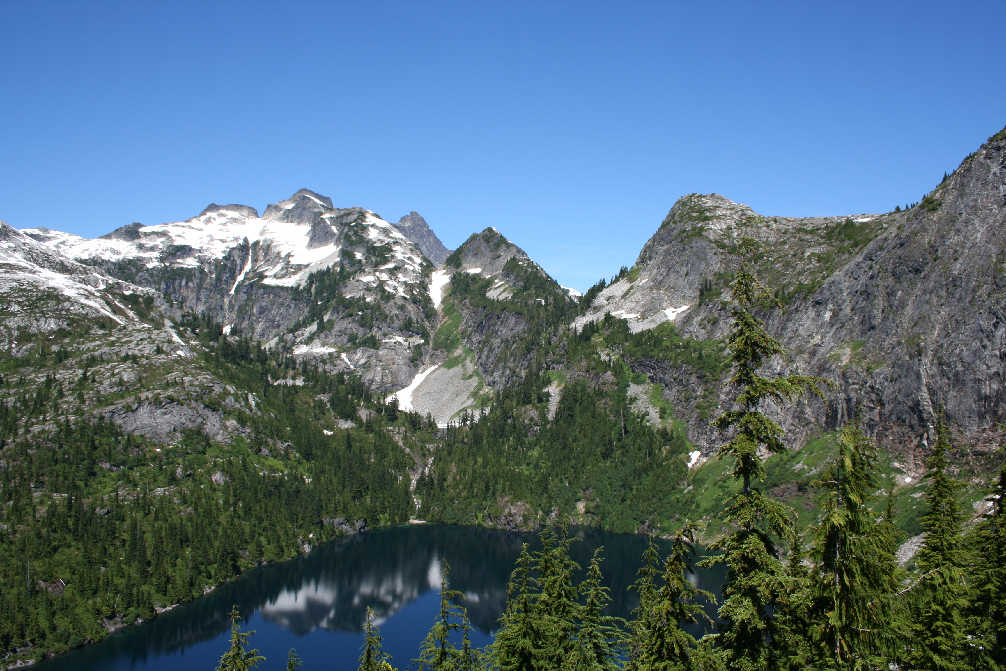
The Thornton Lake Trail traverses the Ross Lake National Recreation Area within the North Cascades National Park Service Complex. This is no casual stroll. You'll ascend over 2,500 feet through dense forest before reaching an alpine basin holding three lakes: Lower Thornton, Thornton, and Trapper. The 10.4-mile out-and-back route takes most fit hikers 6 to 8 hours. Its true value lies in the isolation—leaving State Route 20's crowds for damp cedar scent and granite underfoot. A steep, rocky scramble near the lakes deters the unprepared, preserving the basin's quiet. From Thornton Lake's shore, the sheer north face of 8,285-foot Mt. Triumph rewards the climb.
Quick Information
- Entrance Fee: None. The trailhead is accessed from State Route 20, a public highway. There is no National Park entrance station or fee for day use.
- Hours: The trail is accessible year-round, but snow typically blocks the upper basin from late October through June or July. The access road is not maintained in winter.
- Best Time to Visit: Mid-July through September. This window offers the highest likelihood of snow-free trails, stable weather, and accessible lake basins.
- Location: Washington State, in the Ross Lake National Recreation Area. Nearest services are in Marblemount, about 25 miles west. The trailhead is off State Route 20 near milepost 115.
- Accessibility: Not accessible. The trail is steep, rocky, and includes sections of scrambling. It is not suitable for wheelchairs, strollers, or those with significant mobility challenges.
- Cell Service: None. Expect zero coverage from the trailhead onward. Tell someone your plans.
- Restrooms: There is a single vault toilet at the trailhead parking lot. There are no facilities along the trail or at the lakes. Practice Leave No Trace principles.
- Parking: A gravel lot for approximately 12 vehicles. It fills early on summer weekends. Do not block the gate or park along the narrow access road - you will be ticketed or towed.

Getting There
From the west, drive State Route 20 (North Cascades Highway) east from Marblemount. Continue past the Diablo Lake overlook for roughly 25 miles. Look for a small, unmarked gravel road on the north side of the highway near milepost 115, directly across from a large pull-out on the south side. If you reach the Thornton Lakes Trail sign on the highway, you've gone about 100 yards too far east. Turn onto the gravel road (Forest Road 310) and drive 1.5 miles to the trailhead. The road is rough - potholed and rocky - but passable for most passenger cars with careful driving. High-clearance is recommended. From the east, the drive from Winthrop is about 70 miles via SR 20. Check the NPS alerts page before you go; as of 2026, State Route 20 can close at milepost 130 (Colonial Creek) due to weather or landslides, which would block eastern access. The drive from Seattle takes about 3 hours without traffic.
What to Expect
You start in a second-growth forest of Douglas fir and western red cedar. The trail climbs immediately and doesn't stop for the first three miles. The grade is consistent, the dirt path packed and root-crossed. About 1.5 miles in, you'll cross Thornton Creek on a solid log bridge - the only reliable water source before the lakes. The sound of the creek fades as you climb higher, replaced by the thwack of your trekking poles on rock and your own breathing. The forest begins to thin around the 4-mile mark, offering your first filtered views south toward Pyramid Peak. Then you hit the scramble. The trail narrows here, becoming a steep, rocky chute littered with loose talus. You'll use your hands in a few spots. This section is where most people slow down significantly. Crest the top, and the basin opens before you: Lower Thornton Lake sits in a wooded bowl, Thornton Lake is a deep blue gem backed by sheer cliffs, and Trapper Lake is a smaller tarn tucked higher up. The air is noticeably cooler. Mosquitoes can be fierce in July, but by late August, they're usually gone. The common mistake - and almost everyone makes it - is underestimating the difficulty of the rocky descent on the return trip. Your knees will remind you.

Top Attractions & Points of Interest
Lower Thornton Lake
The first lake you reach. It's forested, quieter, and feels more secluded than its larger sibling. A rough social trail leads to its eastern shore, where you can find flat rocks for a break. It's a good spot if Thornton Lake feels too exposed or windy. The water is cold year-round.
Thornton Lake
The main attraction. A deep, glacially-fed lake sitting directly under the imposing north face of Mt. Triumph. The best views are from the rocky slabs on the lake's southern shore. Early morning is your best bet for calm water that reflects the peak. This is the turnaround point for most day hikers. The water temperature rarely gets above 50°F.
The Talus Scramble
Not a destination, but a defining feature of the hike. This steep, rocky section just before the lakes acts as a natural gatekeeper. It's about 0.3 miles of careful foot placement and minor exposure. In early season, it can hold snow and ice, making it a hazardous climb without traction devices.
Mt. Triumph Views
While you can't summit it from this trail, the view of Mt. Triumph's sheer rock walls from Thornton Lake is one of the most dramatic in the region. The peak catches the late afternoon sun, turning a brilliant orange-red. Photographers wait for this light.
Trapper Lake
A third, smaller lake accessible via a steep, unmaintained climber's path that branches off above Thornton Lake. It's another 400 feet of elevation gain over rough terrain. Only attempt this if you're experienced with off-trail navigation and have plenty of daylight left. The reward is complete solitude.
Activities
The primary activity here is day hiking. The Thornton Lake Trail is a strenuous, full-day endeavor. Pack the ten essentials, including a headlamp. Trekking poles are highly recommended for the descent. While the trail is well-defined, snow can obscure the path well into July; check with the Wilderness Information Center for current conditions before you go.
For backpacking, a free backcountry permit is required for overnight stays. Permits are available at the Wilderness Information Center in Marblemount. There are a few established campsites near Lower Thornton Lake. Fires are prohibited, and all waste must be packed out. This is bear country - use bear canisters, which are available for loan at the ranger station. Planning a longer trip? Our guide to planning a backcountry trip covers the essentials.
Fishing is possible in the lakes, which hold populations of cutthroat trout. A Washington State fishing license is required. The fish are small but plentiful. Fly fishing in the inlet stream of Thornton Lake can be productive in the early morning.
Photography opportunities are best at dawn and dusk. The alpenglow on Mt. Triumph is legendary. A wide-angle lens captures the scale of the basin, while a telephoto is useful for isolating details on the peak's face. A polarizing filter helps cut the glare on the lake surface.

Seasonal Guide
July: The trail is often snow-free to the lakes, but the talus scramble may still have dangerous snow bridges. Mosquitoes are at their peak. Wildflowers explode in the basin. Days are long and warm.
August: Prime time. Bugs subside, trails are dry, and the lakes are (relatively) warm for swimming - if you can stand the cold. Weather is most stable. Crowds are highest on weekends.
September: The best month for solitude and crisp air. Mornings can be frosty. Fall colors start to appear in the basin's blueberry bushes. Days get shorter; start early to finish in daylight.
October through June: The trailhead access road is not plowed. The upper trail and basin are buried under several feet of snow. This becomes a destination for experienced backcountry skiers and snowshoers only. Avalanche hazard is a serious concern.
For a detailed monthly breakdown, see our guide on the best time to visit the North Cascades.
Practical Information
No entrance or parking fees apply. For camping, the nearest frontcountry options are the Colonial Creek Campgrounds (North and South) located about 15 miles east on SR 20. As of 2026, sites are $24 per night and are often booked months in advance for summer weekends. First-come, first-served options include Goodell Creek Campground ($20) near Marblemount. For lodging, the nearest hotels and motels are in Marblemount or Concrete. The more unique North Cascades Lodge at Stehekin requires a ferry or plane trip to reach. The last gas and reliable food before the trailhead are in Marblemount. Fill up your tank and pack a lunch.

Safety & Preparation
Weather: Conditions change fast. Sunny mornings can become cold, windy, and wet by afternoon. Always pack rain gear and extra warm layers, even in summer.
The Scramble: The talus section is the primary hazard. Loose rock is a constant. Wear sturdy boots with good ankle support. Take your time, and test each handhold and foothold.
Water: Treat all water from streams or lakes. Giardia is present. There is no potable water on the trail. Pack extra water for the long, dry climb.
Wildlife: This is black bear and mountain lion habitat. Make noise while hiking, especially in brushy areas. Carry bear spray and know how to use it. For more specifics, our wildlife viewing guide covers safe practices.
Navigation: The trail is clear, but snow patches can obscure it in early season. Carry a map, compass, and/or GPS device. Cell phones are useless for navigation or emergencies here.
Trailhead Security: Break-ins are not uncommon at trailheads along SR 20. The alert is explicit. Remove all valuables, including charging cords, from your vehicle. Leave nothing in sight.
Insider Tips
- The Parking Tell: If the highway pull-out across from the access road is full, the trailhead lot is definitely full. Have a backup hike in mind, like the nearby Thunder Knob Trail.
- Early Season Check: Call the Wilderness Information Center (360-854-7245) before your trip. They know exactly how much snow is on the scramble and whether it's passable without ice axes.
- Swimming is Theoretical: The lakes are fed by snowmelt. Even on an 80°F day, the water is painfully cold. Jumping in is a brief, shocking experience. Dry off fast.
- The Quiet Lake: Most day hikers stop at Thornton Lake. If you want absolute quiet, follow the faint path another 10 minutes to Lower Thornton Lake. You'll likely have it to yourself.
- Post-Hike Burger: The drive back to Marblemount is long. The Buffalo Run Inn restaurant there is a local institution for a reason. Their burgers and milkshakes are a ritual after a big hike.
- Light Matters: If you're a photographer, plan to arrive at the lake in the late afternoon. The sun drops behind the ridge early, but the alpenglow on Mt. Triumph that follows is what you're after.
- Gate Status: The winter gate on the access road is closed by the first significant snowstorm, usually in November. Don't assume you can drive to the trailhead between November and May - always check.
For more information, see our complete North Cascades National Park Guide.
Sources
- Official source: National Park Service nps.gov/places/thornton-lake-trail.htm
- Official source: NPS — North Cascades National Park nps.gov/noca/index.htm
Photo Gallery
More to Explore

Park Guide
Acadia National Park: Carriage Roads, Cadillac Mountain & 2026 Guide
Discover carriage roads, Cadillac Mountain, and rugged Maine coast. Complete 2026 guide to Acadia National Park — trails, fees, lodging, permits, and what rangers recommend.

Hiking Guide
Grand Canyon Hiking Trails: Day Hikes, Water Sources & Rim to Rim
Compare Grand Canyon hiking trails: Bright Angel, South Kaibab, Hermit, Grandview, and rim to rim, with distances, elevation, water stops, and trailhead access for each.

Best Of
Best of Glacier Bay National Park
The best of Glacier Bay is reached by boat: ranger-led day tours up the bay to the tidewater glaciers. What's worth it, how to book, and when to go (2026).

Campsite Guide
White Sands Backcountry Camping: Closed for 2026 — What to Know
As of 2026, backcountry camping at White Sands National Park is closed for site rehabilitation. What that means, and where to camp nearby instead.

Weather Guide
Guadalupe Mountains National Park Weather: Weather
Guadalupe Mountains National Park: weather guide guide updated 2026. Practical visitor information, reservations, and seasonal tips worth bookmarking before

Best Of
Best of Cuyahoga Valley National Park: Best Things to Do
Seeing a Cleveland Orchestra concert with the woods as your backdrop is a uniquely Cuyahoga Valley experience.
Sign in to join the conversation.
Sources & Attribution
Location data courtesy of the National Park Service (U.S. Department of the Interior). NPS data is public domain. Official NPS page.
Images: NPS; NPS; NPS; NPS; NPS.
Map data © OpenStreetMap contributors.
Park operations alerts: NPS.gov · Weather and weather hazards: National Weather Service · Live conditions.
Information may change. Always verify fees, hours, and conditions directly with the official source before visiting.
Did this guide help? Share it with a friend.