The Emerald Ridge Trail is a 5.5-mile connector route through Redwood National and State Parks. Don't expect a destination grove or famous tree at the terminus. Instead, you'll experience a steady, solitary climb through recovering forest that culminates on a ridgeline where the air thins and sightlines expand. The path narrows to a single track of packed dirt and pine needles, carrying the constant scent of damp earth and bay laurel. This is a trail for those who prefer to earn their views.
NPS via NPS.gov (Public Domain)
Emerald Ridge Trail: 5.5-Mile Connector, Redwood
9 min read
Places & Points of Interest
Plan your 2026 visit to Emerald Ridge Trail. Complete guide to trails, fees, lodging, best time to visit, and insider tips.
Your plans
Overview
The Emerald Ridge Trail serves as a functional artery in the southern section of the parks, linking the Tall Trees Trailhead area with the upper reaches of Bald Hills Road. Its purpose is connective, not ceremonial. The lower sections wind through second-growth forest - a landscape of young redwoods, Douglas firs, and tan oaks that have reclaimed old logging roads. The sound changes as you climb: the low rush of Redwood Creek fades, replaced by wind in the canopy and the occasional chatter of a Steller's jay. The trail's value is in its transition. You start under a closed canopy and emerge onto a grassy ridge with sightlines that stretch for miles. Rangers will tell you it's one of the least crowded paths in the area, precisely because it doesn't lead to a marquee attraction. It leads to space.
Quick Information
- Entrance Fee: Redwood National and State Parks do not charge an entrance fee. Some state park day-use areas may have a $5-8 fee, but access to the Emerald Ridge trailhead does not require payment.
- Hours: The trail is accessible year-round, but the gate on Bald Hills Road closes seasonally. Check the park website for current gate status as of 2026.
- Best Time to Visit: Late May through October. This avoids the heaviest winter rains that make the trail muddy and ensures the Bald Hills Road gate is open for easier access.
- Location: Northern California, Redwood National Park. Nearest services are in Orick. The primary trailhead is off Bald Hills Road.
- Accessibility: This is a natural surface hiking trail with significant elevation gain. It is not wheelchair or stroller accessible.
- Cell Service: Unreliable to nonexistent for the entire length of the trail and at the trailheads.
- Restrooms: A vault toilet is available at the Tall Trees Trailhead parking area. There are no facilities along the trail itself.
- Parking: Limited parking at the Tall Trees Trailhead pullout. The lot can fit about 8-10 vehicles. No fee.

Getting There
The most straightforward access is from Bald Hills Road, off Highway 101 about two miles north of Orick. Drive up Bald Hills Road for approximately 6.5 miles. You'll see a small, unmarked pullout on the left (east) side of the road; this is the upper trailhead. There's no sign - just a break in the vegetation where the trail enters the woods. If you reach the Lady Bird Johnson Grove parking lot, you've gone about a mile too far.
For a longer hike, start at the lower Tall Trees Trailhead. This requires a free, timed reservation permit from the park website to drive the locked access road. From the trailhead, the Emerald Ridge Trail begins near the informational kiosk. The drive from Crescent City is about 45 minutes; from Eureka, plan on 90 minutes. Fill your gas tank in Orick or Klamath; there are no services on Bald Hills Road.
What to Expect
Prepare for sustained elevation gain. From the lower trailhead to the ridge, the trail climbs over 1,500 feet. The initial mile from the Tall Trees area follows an old roadbed through dense forest with deceptively gentle terrain. The surface remains soft with accumulated duff. Around the 1.5-mile mark, the trail begins its earnest ascent through long, steady switchbacks. This section passes through mixed second-growth forest where mid-century logging stumps stand alongside vigorous young redwoods.
The air gets noticeably drier as you ascend. Around the 4-mile mark, the trees begin to thin, giving way to manzanita and open grassy slopes. The final approach to the ridge is through a sun-drenched corridor of brush. From the high point, the view is sudden and immense: to the west, the endless blue-gray of the Pacific; to the east, the rumpled green ridges of the Coast Range. On a clear day, you can trace the thin line of Redwood Creek snaking through the valley almost 2,000 feet below. The silence up here is different - a wide, windy quiet. You'll share it with turkey vultures riding the thermals and the faint, sweet smell of warm grass.

Top Attractions & Points of Interest
The Transition Zone
About two miles in, the forest composition visibly shifts. This is where the damp, dense understory of the creek valley gives way to a drier, more open woodland. Sunlight reaches the floor. It's a good place to catch your breath and notice the change in birdlife - fewer wrens, more woodpeckers.
The First Viewpoint
A short, unofficial spur about 0.2 miles before the true ridge crest offers a framed view northwest. It's a preview. This is where most people stop, take a photo, and think they've reached the top. They haven't.
Emerald Ridge Crest
The actual crest isn't a single point but a long, rolling spine of grassland. This is the reward. Find a flat rock off the trail, sit, and watch the fog pour over the coastal hills like slow-motion waves. The scale is what gets you. The Tall Trees Grove, a major destination requiring a permit, is just a patch of darker green in the vast basin below.
Connector to Dolason Prairie Trail
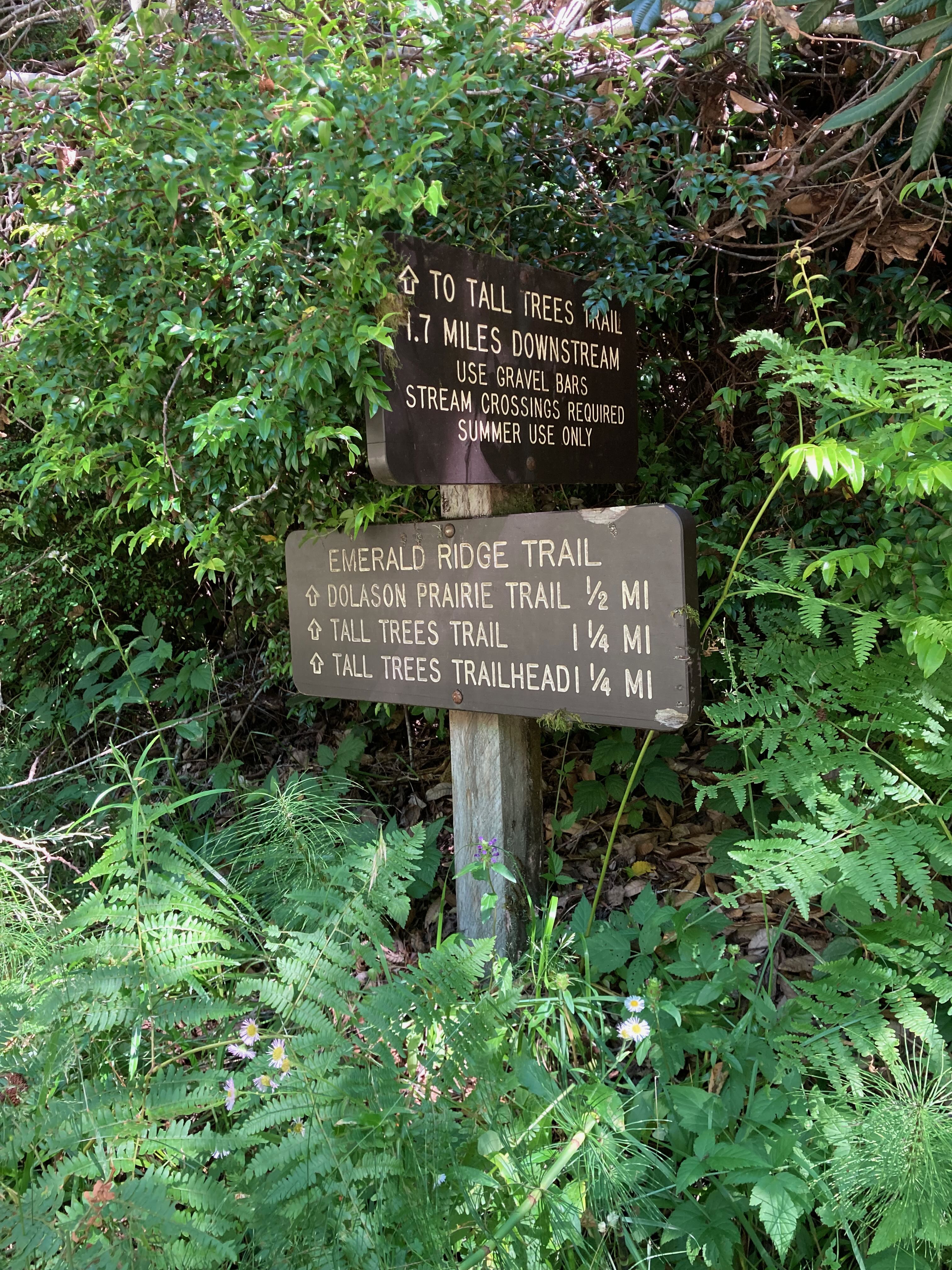
For the ambitious, the Emerald Ridge Trail junctions with the Dolason Prairie Trail, which plunges back down into the Redwood Creek valley. This is for through-hikers or those with a shuttle car. The junction is signed but subtle.
Seasonal Wildflower Display
In June and early July, the upper slopes of the ridge explode with color. Look for lupine, Indian paintbrush, and clumps of vibrant yellow bush poppy. It's a stark, beautiful contrast to the green tunnel you hiked through below.
Activities
Hiking: This is the primary activity. The Emerald Ridge Trail is a solid out-and-back day hike from either trailhead. From the upper Bald Hills Road access, it's a shorter, steeper hike to the crest and back (roughly 4 miles round-trip). From the lower Tall Trees Trailhead, it's a full 11-mile round-trip journey with serious elevation gain. Most visitors underestimate the climb back up from the creek valley if they do the full loop - your legs will know it the next day.
Wildlife Viewing: This is a good trail for quieter observation. Black-tailed deer are common in the grassy clearings. Listen for the scratchy chatter of the dusky-footed wood rat in the brush piles. The open ridge is prime territory for raptors; red-tailed hawks are a constant presence. For more consistent wildlife viewing opportunities, the elk prairies are more reliable.
Photography: The best light is in the late afternoon, when the sun slants across the grassy ridge, creating long shadows and highlighting the texture of the hills. Morning light can be beautiful but is often obscured by coastal fog. The viewpoint offers a classic layered landscape shot: foreground grass, middle-distance forested valleys, distant ocean.
Backpacking Connector: The trail is a key link for backpackers creating loops in the Redwood Creek basin. It provides access to the 44 Backcountry Camp and other sites, connecting the high ridges with the valley floor. A free backcountry permit is mandatory for any overnight stay.

Seasonal Guide
May - June: Ideal. Bald Hills Road is open, temperatures are cool, wildflowers on the ridge are peaking, and the summer fog hasn't settled in for its long stay. This is the most reliable window for clear views.
July - September: Summer brings persistent coastal fog to the ridge, often obscuring views until late afternoon, if at all. Temperatures are pleasant for hiking, but carry layers - it can be 55°F and windy on the ridge while it's 75°F in the parking lot. This is the busiest time in the park, but this trail remains relatively quiet.
October - November: A gamble with high reward. The fall can bring crisp, clear days with incredible visibility after the first rains settle the dust. The gate on Bald Hills Road may close with the first significant storm, usually in late October or November. Check the best time to visit page for current conditions.
December - April: The trail is often wet, muddy, and cold. The Bald Hills Road gate is closed, adding miles of road walking to access the upper trailhead. Only for prepared hikers with proper rain gear and an appetite for solitude. Stream crossings on the lower sections can be hazardous.
Practical Information
No fees or permits are required to hike the Emerald Ridge Trail itself. However, if you plan to start at the lower Tall Trees Trailhead, you must secure a free, timed vehicle permit online in advance. These are limited and release 48 hours prior.
For camping options, the nearest drive-in campgrounds are Elk Prairie Campground ($35/night as of 2026) and Gold Bluffs Beach Campground. Backcountry camping requires a free permit, available at the Kuchel Visitor Center in Orick. For lodging and accommodations, look to the towns of Orick, Klamath, or Crescent City.
There are no restaurants, water, or gas stations on Bald Hills Road. The last chance for supplies is in Orick, which has a small market. Pack all the water and food you'll need for the day.

Safety & Preparation
Weather: Conditions change rapidly. The ridge is exposed to wind and weather. A sunny start can turn into a cold, foggy summit. Carry wind and rain layers regardless of the forecast.
Navigation: The trail is generally well-defined but can be overgrown with grass on the upper sections in late summer. Download or print a map. The junction with the Dolason Prairie Trail is the only major intersection; pay attention.
Water: There are no reliable water sources along the trail. Carry all you will need - at least 2 liters per person for the full hike from the lower trailhead. More on hot days.
Wildlife: Roosevelt elk are occasionally seen on the open slopes. Give them a wide berth, especially during the fall rut. Ticks can be present in the grassy areas; do a check after your hike.
Emergency: Cell service is absent. Let someone know your plans. The nearest ranger station is the Kuchel Visitor Center in Orick. In an emergency, you may need to hike out to reach help.
Insider Tips
- The Unmarked Start: The upper trailhead on Bald Hills Road has no sign. Look for the mile marker 6.5 and a faint path leading into the woods. If you see a wide gravel pull-off, you're in the right place.
- Permit Hack: If you can't get a Tall Trees vehicle permit, you can still hike the entire Emerald Ridge Trail from the top. Park at the Lady Bird Johnson Grove, walk back down Bald Hills Road about a mile to the upper trailhead, hike down to the creek valley, and then hike back up. It adds road walking but avoids the permit system.
- Fog Strategy: If the ridge is fogged in when you arrive, wait 20 minutes. The fog bank often lifts and lowers in cycles. The view can appear and disappear multiple times in an hour.
- Skip the Midday Hike: The climb is entirely south-facing and gets hot in the afternoon sun. An early morning start means cooler temperatures and a better chance of clear skies before the marine layer pushes in.
- Footwear: Trail runners or hiking shoes with good tread are sufficient for the dry season. After rains, the trail can be slick; trekking poles are highly recommended for the descent.
- Quiet Time: You are far more likely to see wildlife if you hike quietly and alone. Groups of three or more tend to see only the backs of fleeing deer.
- What the Website Doesn't Mention: The most impressive sense of scale isn't from the very top of the ridge, but about 0.3 miles back down the trail toward Tall Trees. A small break in the trees offers a dizzying, straight-down view into the canyon that perfectly illustrates the elevation you've just gained. Most people miss it on the way up.
For more information, see our complete Redwood National Park Guide.
Sources
- Official source: NPS — Redwood National Park nps.gov/redw/index.htm
- Official source: National Park Service nps.gov/places/emerald-ridge-trail.htm
Photo Gallery
More to Explore

Park Guide
Acadia National Park: Carriage Roads, Cadillac Mountain & 2026 Guide
Discover carriage roads, Cadillac Mountain, and rugged Maine coast. Complete 2026 guide to Acadia National Park — trails, fees, lodging, permits, and what rangers recommend.

Hiking Guide
Grand Canyon Hiking Trails: Day Hikes, Water Sources & Rim to Rim
Compare Grand Canyon hiking trails: Bright Angel, South Kaibab, Hermit, Grandview, and rim to rim, with distances, elevation, water stops, and trailhead access for each.

Best Of
Best of Glacier Bay National Park
The best of Glacier Bay is reached by boat: ranger-led day tours up the bay to the tidewater glaciers. What's worth it, how to book, and when to go (2026).

Campsite Guide
White Sands Backcountry Camping: Closed for 2026 — What to Know
As of 2026, backcountry camping at White Sands National Park is closed for site rehabilitation. What that means, and where to camp nearby instead.

Weather Guide
Guadalupe Mountains National Park Weather: Weather
Guadalupe Mountains National Park: weather guide guide updated 2026. Practical visitor information, reservations, and seasonal tips worth bookmarking before

Best Of
Best of Cuyahoga Valley National Park: Best Things to Do
Seeing a Cleveland Orchestra concert with the woods as your backdrop is a uniquely Cuyahoga Valley experience.
Sign in to join the conversation.
Sources & Attribution
Location data courtesy of the National Park Service (U.S. Department of the Interior). NPS data is public domain. Official NPS page.
Images: NPS; NPS; NPS; NPS; NPS.
Map data © OpenStreetMap contributors.
Park operations alerts: NPS.gov · Weather and weather hazards: National Weather Service · Live conditions.
Information may change. Always verify fees, hours, and conditions directly with the official source before visiting.
Did this guide help? Share it with a friend.