Secure your free backcountry permit before you even think about packing your bag. That's the single most important piece of advice for anyone planning a trip to 44 Backcountry Camp. This semi-developed site is your gateway to the deep, quiet heart of Redwood National and State Parks, offering a designated spot to sleep among giants that few day-hikers ever see. It's not a drive-up campground; it's a destination earned by foot, and that changes everything about the experience.
NPS via NPS.gov (Public Domain)
44 Backcountry Camp: Permit Required, Redwood National Park
10 min read
Places & Points of Interest
Plan your 2026 visit to 44 Backcountry Camp. Complete guide to trails, fees, lodging, best time to visit, and insider tips.
Your plans
Overview
44 Backcountry Camp is a designated, semi-developed site within Redwood National Park in northern California. It sits at an elevation of roughly 340 feet, positioned in the forest near Redwood Creek. The camp's primary purpose is to serve as a basecamp for hikers visiting the legendary Tall Trees Grove, a collection of some of the world's tallest living organisms. What makes this place special isn't just the amenities—a picnic table, grill, and fire pit—but its location. You'll spend the night in a cathedral of old-growth redwoods, where daytime crowds have vanished and the only sounds are the creek and wind through branches 300 feet overhead. The air carries the scent of damp earth, redwood bark, and the faint, sweet decay of the forest floor. This is where a visit shifts from sightseeing to immersion.
Quick Information
- Entrance Fee: Access to Redwood National and State Parks is free. However, a free backcountry permit is required to stay at 44 Camp. As of 2026, no park entrance fee is charged.
- Hours: The backcountry is accessible 24/7, but camping is only allowed at designated sites with a permit. The Tall Trees Grove trailhead access gate is open from 8:00 AM to 30 minutes after official sunset.
- Best Time to Visit: Late spring (May-June) and early fall (September-October). These windows offer the most reliable dry trails, moderate temperatures, and fewer mosquitoes than summer. Summer fog is common near the coast but less so inland at the camp.
- Location: Northern California, within Redwood National Park. Nearest services are in Orick, about a 30-minute drive from the trailhead. GPS coordinates for the camp are 41.21510308, -124.01906732.
- Accessibility: The trail to 44 Camp is not wheelchair accessible. It involves a significant hike with elevation change. The camp itself has a flat tent pad area.
- Cell Service: Do not expect any reliable cell service at the trailhead, along the route, or at the 44 backcountry camp. Assume you will be out of contact.
- Restrooms: A vault toilet is available at the camp. There are no restrooms at the Tall Trees Grove trailhead parking area.
- Parking: The Tall Trees Grove trailhead has a small, paved parking lot that can accommodate about 15-20 vehicles. It is used by both day-hikers with reservations and backcountry campers. It rarely fills to capacity due to the reservation system.

Getting There
Reaching 44 Camp involves two stages: a drive to a remote trailhead, then a hike.
From Orick on US Highway 101, turn onto Bald Hills Road. Drive east for about 6.5 miles. You'll see a signed turnoff for Tall Trees Grove on the left, marked by a locked gate. To obtain the access code, you need a confirmed free reservation for the Tall Trees Grove day-use area or a valid backcountry permit for 44, Elam, or Emerald Ridge camps, issued online by the park. The 6.5-mile road from the gate to the trailhead is narrow, winding, and paved. Drive slowly—this is elk and bear country. The final parking lot is small and lacks facilities.
From Crescent City, drive about 45 minutes south on US 101 to Orick, then follow these directions. above. From Eureka, it's about 45 minutes north.
The parking situation here is straightforward but absolute: no permit code, no entry past the gate. Rangers do check.
What to Expect
Expect a hike that feels longer than the mileage suggests. The trail to 44 Camp from the Tall Trees Grove trailhead is approximately 3.3 miles one-way. The path descends over 800 feet into the Redwood Creek drainage. The first section is a series of switchbacks through dense, sun-dappled forest of redwood, Douglas-fir, and tanoak. The trail narrows here, with a soft surface of decomposed needles and dirt. About a mile in, you'll cross a sturdy footbridge; the sound of Redwood Creek becomes a constant companion after this point. The grade eases as you approach the creek bottom.
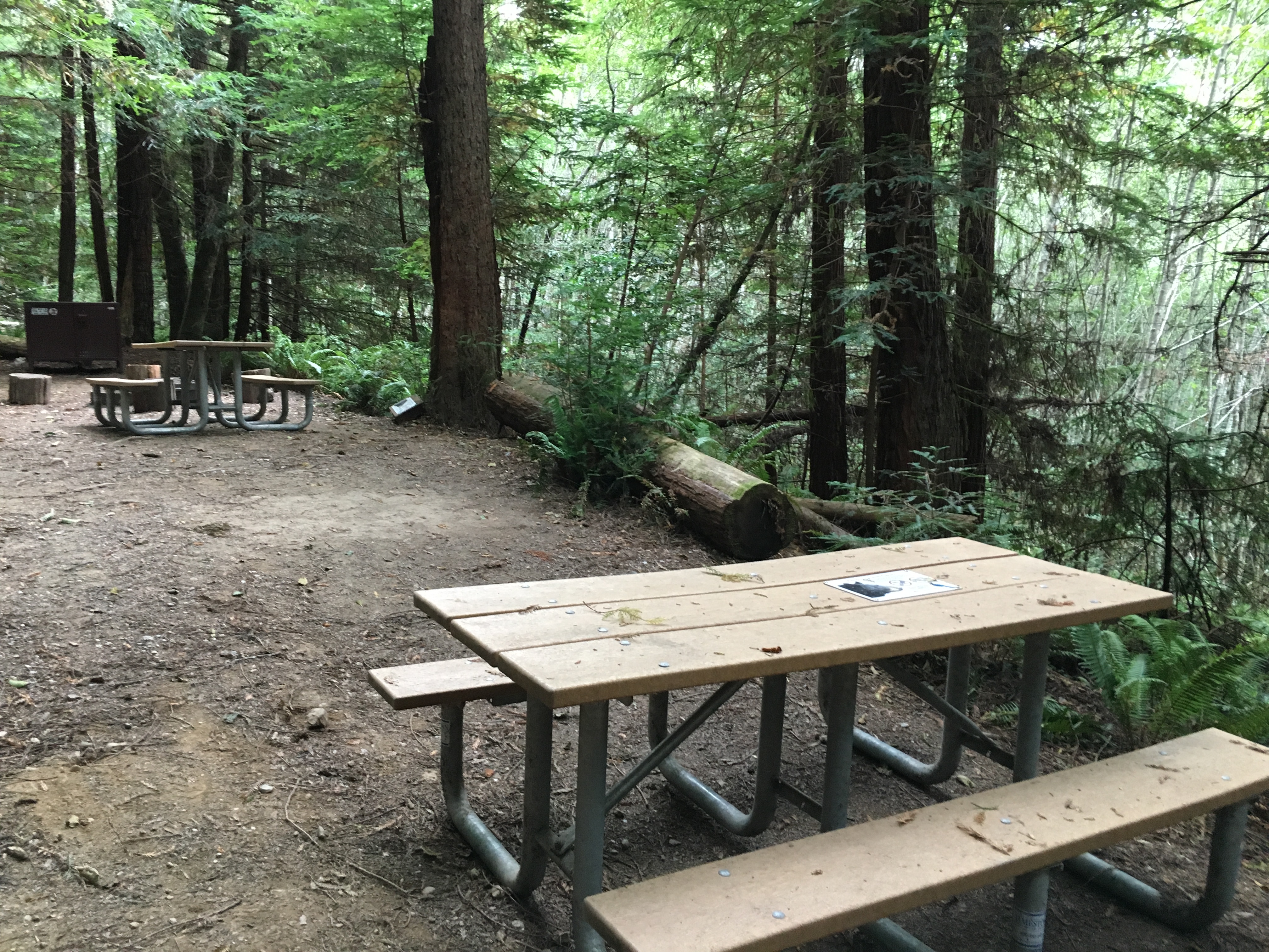
The camp itself is a cleared area under a towering canopy. You'll find a metal bear-proof food storage locker - use it for all food, trash, and scented items. There's a picnic table, a metal grill, and a fire ring (check for current fire restrictions, which are common in summer and fall). A single tent pad is designated. The proximity to Redwood Creek means humidity is high and temperatures can be 10-15 degrees cooler than the trailhead. The sound of the creek masks other forest noises, creating a deep, rushing white noise all night.
Most first-time visitors are caught off guard by the sheer density of the quiet. With no road noise, the forest's own sounds become amplified: the chatter of a varied thrush, the distant croak of a raven, the occasional crack of a branch falling from a colossal height. The common mistake - and almost everyone makes it - is underestimating the hike back out. That 800-foot climb feels substantial with a full pack in the morning.

Top Attractions & Points of Interest
Tall Trees Grove
This is the crown jewel accessible from 44 Camp. It's about a 1.5-mile hike (one-way) from the camp further down the trail. The grove shelters the Libbey Tree, once considered the world's tallest, and numerous other giants over 350 feet. The experience of having these trees to yourself in the early morning or late afternoon, without the day-hiker crowds, is the primary reason to stay at 44. Hike here first thing in the morning.
Redwood Creek
The creek is more than a backdrop; it's a destination. In late summer and early fall, water levels can be low enough to allow for careful wading or exploring gravel bars. The water is cold year-round. It's your water source - bring a reliable filter or purification system. Sitting by the creek in the evening is the best alternative to a campfire when restrictions are in place.
The Hike Itself
For many, the 6.6-mile round-trip journey is the main attraction. The trail is a classic example of the park's old-growth ecosystem. Look for banana slugs on damp mornings, nurse logs sprouting new trees, and the intricate lattice of sword ferns. The trail offers a continuous study in scale, from the massive trunks at your side to the filtered light far above.
Emerald Ridge Trail Junction
Near the camp, you'll see the junction for the Emerald Ridge Trail. This is your route to the other backcountry sites (Elam Camp) and a much more strenuous loop option for a second day. The junction is a good reminder of the larger trail network you're embedded in.
Activities
The activity at 44 Camp is fundamentally backpacking. This is a wilderness experience. Your activities will center on camp chores, exploring the immediate area, and day-hiking without your full pack.
Hiking: The main event is the hike to the Tall Trees Grove. Without a heavy pack, the 3-mile round-trip from camp is a pleasant stroll. You can also explore upstream or downstream along Redwood Creek, though there is no maintained trail and travel is slow over cobbles and logs.
Photography: The light is best in the grove during mid-morning or late afternoon, when sunbeams slice through the canopy. At camp, macro photography of ferns, fungi, and creek details can be rewarding. A tripod is essential for the low-light conditions under the trees.
Wildlife Viewing: This is a prime area for black bears. You will likely not see them if you store food properly, but you may hear them or see scat. Roosevelt elk are less common this deep in the forest but not impossible. More likely are squirrels, varied thrushes, and pileated woodpeckers. For dedicated wildlife viewing, the open prairies are better, but here you observe the forest's quieter residents.
Relaxation: This is a key activity. Reading a book at the picnic table, listening to the creek, and simply being still are what make a night at 44 Camp memorable. There are no schedules, no lines, no noise.

Seasonal Guide
May - June: Often the ideal window. Winter rains have tapered off, creek levels are safe for crossing, trails are dry, and the mosquito population hasn't peaked yet. Daytime highs at camp can reach the low 70s, nights dip into the 40s.
July - August: Peak summer. This is the busiest time for the Tall Trees Grove day-use reservation system, but the backcountry camp often remains quiet. Coastal fog is thick most mornings but usually burns off by afternoon inland. Mosquitoes and flies can be persistent near the creek. Afternoon temperatures can be warm, but nights remain cool. Fire restrictions are almost always in effect.
September - October: Another excellent choice. Crowds diminish, insects subside, and the chance of early rain is low. The first hints of fall color appear in the bigleaf maples. This is arguably the most comfortable best time to visit for backpacking.
November - April: The wet season. The Tall Trees Grove road may close due to storm damage or hazardous conditions. Hiking is possible during dry spells, but Redwood Creek can become impassable and the trail muddy. This season is for experienced, well-equipped backpackers only. The permit is still required, but you'll likely have the entire grove to yourself.
Practical Information
Permits: A free backcountry permit is mandatory for 44 Camp. These are obtained online through the National Park Service's reservation system. They are limited, but not as fiercely competitive as some other parks. You should still book well in advance for summer weekends. The permit also grants you the access code for the Tall Trees Grove road gate.
Fees: As of 2026, there is no charge for the backcountry permit or park entry.
Campgrounds: 44 is a backcountry site. For frontcountry camping options, the nearest are Elk Prairie Campground and Gold Bluffs Beach Campground, both about a 45-minute drive from the Tall Trees trailhead. Reservations for those are highly competitive and require planning months ahead.
Lodging: The nearest motels and vacation rentals are in Orick, Trinidad, and Crescent City. For more comfortable lodging and accommodations, you'll need to look to those communities.
Gear: You must bring all your own backpacking gear, including a bear-resistant food canister (required), water filter, stove, and weather-appropriate shelter. There are no rentals at the trailhead.
Water: Redwood Creek is the only water source. Filter or treat all water.

Safety & Preparation
Bears: This is active black bear habitat. The metal food locker at camp is there for a reason. Use it for ALL food, trash, toiletries, and cooking gear. Never keep these items in your tent. If you see a bear, make noise to alert it to your presence - do not run.
Weather: Conditions can change rapidly. Rain is possible any month. The temperature differential between the trailhead and creek bottom is significant. Pack layers, including a warm hat and rain gear, even in summer.
Trail Conditions: The trail is well-maintained but can be muddy, with slippery roots and rocks. Trekking poles are highly recommended for the descent and especially for the climb out. The footbridge can be slick when wet.
Water Safety: Redwood Creek is cold and can rise quickly with rain. Never attempt to cross the main creek to reach the Tall Trees Grove if water levels are high; the current is stronger than it looks. The designated trail uses a bridge for a reason.
Emergency: You are on your own. Cell service drops out at the trailhead. Inform someone of your itinerary and expected return time. In a true emergency, a day-hiker would need to hike out to the trailhead and drive to find cell service to call for help. Consider a satellite communication device.
Insider Tips
- Pack Extra Water for the Climb Out: Filter enough water at the creek in the morning to get you all the way back to your car. You won't want to stop and filter on the steepest switchbacks, and there's no source on the trail.
- The Best Sunset View Isn't at Camp: For the last light of the day, walk a few minutes back up the trail from camp to a small clearing where the tree canopy opens slightly. You won't see the sun, but the tops of the redwoods will glow orange-pink.
- Earplugs: The sound of Redwood Creek is constant and loud. Some find it soothing; others find it prevents sleep. A pair of foam earplugs can be a trip-saver.
- Permit Hack: If the Tall Trees Grove day-use reservations are fully booked, you can still often get a backcountry permit for 44 Camp. Your permit grants you road access, allowing you to visit the grove as a day-hiker from your camp.
- Skip the Campfire: Even when fires are allowed, the smoke tends to hang in the damp, still air under the canopy. A small backpacking stove is far more efficient, and you'll enjoy the pristine air.
- Check the Trail Register: At the trailhead, there's often a clipboard with a trail register. It's worth a quick look for notes from other hikers about recent bear activity, trail conditions, or water levels at the creek crossings.
- What the Website Doesn't Mention: The picnic table at 44 Camp is often damp with condensation or moss. A small pack towel or sit pad is worth its weight for meal times.
For more information, see our complete Redwood National Park Guide.
Sources
- Official source: NPS — Redwood National Park nps.gov/redw/index.htm
- Official source: National Park Service nps.gov/places/44backcountrycamp.htm
Photo Gallery
More to Explore

Park Guide
Acadia National Park: Carriage Roads, Cadillac Mountain & 2026 Guide
Discover carriage roads, Cadillac Mountain, and rugged Maine coast. Complete 2026 guide to Acadia National Park — trails, fees, lodging, permits, and what rangers recommend.

Hiking Guide
Grand Canyon Hiking Trails: Day Hikes, Water Sources & Rim to Rim
Compare Grand Canyon hiking trails: Bright Angel, South Kaibab, Hermit, Grandview, and rim to rim, with distances, elevation, water stops, and trailhead access for each.

Best Of
Best of Glacier Bay National Park
The best of Glacier Bay is reached by boat: ranger-led day tours up the bay to the tidewater glaciers. What's worth it, how to book, and when to go (2026).

Campsite Guide
White Sands Backcountry Camping: Closed for 2026 — What to Know
As of 2026, backcountry camping at White Sands National Park is closed for site rehabilitation. What that means, and where to camp nearby instead.

Weather Guide
Guadalupe Mountains National Park Weather: Weather
Guadalupe Mountains National Park: weather guide guide updated 2026. Practical visitor information, reservations, and seasonal tips worth bookmarking before

Best Of
Best of Cuyahoga Valley National Park: Best Things to Do
Seeing a Cleveland Orchestra concert with the woods as your backdrop is a uniquely Cuyahoga Valley experience.
Sign in to join the conversation.
Sources & Attribution
Location data courtesy of the National Park Service (U.S. Department of the Interior). NPS data is public domain. Official NPS page.
Images: NPS; NPS; NPS; NPS; NPS.
Map data © OpenStreetMap contributors.
Park operations alerts: NPS.gov · Weather and weather hazards: National Weather Service · Live conditions.
Information may change. Always verify fees, hours, and conditions directly with the official source before visiting.
Did this guide help? Share it with a friend.