Voyageurs National Park is 218,000 acres of lakes and forest where roads end and water begins—you'll need a boat to reach most of the park. Plan around the average ice-out date of May 3, as that determines when the waterways open for the season.
NPS via NPS.gov (Public Domain)
Voyageurs National Park: Minnesota's Lake Country by Boat - 2026 Guide
7 min read
Park Guide
Explore Voyageurs National Park (2026): a boat-only wilderness with four major lakes and a roadless peninsula. Learn about ice-out dates, launch points, and camping permits.
Your plans
This article contains affiliate links — we may earn a small commission at no extra cost to you.
At a glance
Hours
Voyageurs is open 24-hours a day year-round, although activities and services are limited after visi
Best Time
June-September (summer), September-October (fall colors)
Address
Voyageurs National Park, International Falls, MN, 56649
Website
48.4837, -92.8383
Google MapsThe Lay of the Land: Four Lakes and a Peninsula
Water defines Voyageurs. Four major lakes—Rainy, Kabetogama, Namakan, and Sand Point—serve as the park's primary waterways. The Kabetogama Peninsula sits between them, a roadless wilderness of forest and interior lakes reachable only by boat or on foot. This geography shapes every aspect of a visit.
Choosing Your Gateway
You don't just go to Voyageurs National Park; you go to a specific part of it. Your experience hinges on which lake you access. Rangers will tell you each has a different character.
Rainy Lake, near International Falls, is the largest and most developed for visitors. The Rainy Lake Visitor Center here is the park's main hub. Kabetogama Lake, to the west, feels more secluded, with a smaller visitor center tucked into the community of Kabetogama. The Ash River area, on the south shore of Kabetogama, offers mid-lake access. Crane Lake, at the far western end, is the gateway to Sand Point Lake and the remote, rugged western stretches.
The parking situation here is straightforward: ample paved lots at the visitor centers. The lots for the boat launches fill early, especially on summer weekends. By 8:30 AM on a Saturday in July, you might be parking in the overflow.
The Kabetogama Peninsula: The Park's Wild Core
This is the heart of the backcountry. The peninsula holds 26 smaller interior lakes, 15 of which have camping options. To reach them, you boat to a trailhead, then hike or paddle-portage in. The Cruiser Lake Trail, a rugged path across the peninsula, is the park's premier long hike, but its trailhead is only accessible by water. This is the central truth of Voyageurs: the best of it requires leaving your car behind.

Getting on the Water: Your Transportation Options
With nearly all campsites requiring boat access, your choice of watercraft becomes the most important planning decision. Many first-time visitors don't grasp the distances involved. Rainy Lake stretches 60 miles end to end. A simple trip to a trailhead might cover 10-15 miles one way.
Bring Your Own Boat
Motorboats are common. The big lakes can get choppy in afternoon winds, so a stable, seaworthy craft is advised. Canoes and kayaks are perfect for exploring sheltered bays like Blind Ash Bay or making the journey to interior lakes. The park maintains a series of portage trails between lakes, some with wheels provided for your canoe. Paddling the open expanse of Rainy Lake in a kayak, however, is a serious undertaking best left to experienced boaters with weather awareness.
Rentals and Tours
If you don't have a boat, you're not out of luck. Local marinas near each visitor center rent everything from fishing boats and pontoons to canoes and kayaks. Reserve these months in advance for summer dates.
The other solution is to join a tours and guided experiences. The park service runs ranger-led boat tours from the Rainy Lake and Kabetogama Lake visitor centers. These 90-minute to 6.5-hour trips are the only way for many to reach sites like the Ellsworth Rock Gardens or Kettle Falls Hotel. They book up. Call the visitor center or check Recreation.gov as soon as you know your dates.
Winter Redefines Access
The average ice-out date is May 3. From late January through March, the lakes transform into a network of ice roads and snowmobile trails. This is when you can drive a truck to the Kabetogama Peninsula or snowmobile to a remote bay for ice fishing. Early spring and late fall present the hazard of thin ice; the park service posts conditions, but local knowledge is king. Cell service drops out on the lake, so go prepared.

What to Actually Do: Beyond the Boat
A common mistake is to focus solely on the boating and miss the destinations. Each lake holds points of interest that are worth the trip.
Historic Sites and Gardens
Ellsworth Rock Gardens is the park's most peculiar treasure. Only accessible by water, this "Showplace of Lake Kabetogama" features over 200 rock sculptures and terraced gardens built by one man over two decades. It feels both grand and intimate.
Kettle Falls Hotel, also boat-access only, is the only lodging within park boundaries. You can tie up at the dock, have lunch at the historic hotel, and watch the old Kettle Falls dam operate.
Little American Island, a short boat ride from the Rainy Lake Visitor Center, offers a self-guided walk through a late-1800s gold mining site. It's a quick, fascinating stop that adds a layer of human history to the landscape.
Harry Oveson Fish Camp and Hoist Bay preserve the stories of commercial fishing and logging, respectively. These are day-use sites with picnic tables and relics to explore.
Hiking from the Water
The park's hiking trails are largely accessed via boat. The Locator Lake Trail (2-5 hours) involves a boat ride, a hike, and then a canoe portage into a chain of small lakes - a true adventure. The Anderson Bay Loop (90-150 minutes) rewards a 19-mile boat ride from Rainy Lake Visitor Center with spectacular cliff-top views.
For a taste without a long boat commitment, the Blind Ash Bay Trail (1-3 hours) starts near the Rainy Lake Visitor Center. It's a narrow, rocky path through classic boreal forest. On land, the Rainy Lake Recreation Trail is a paved, peaceful path near the visitor center, and the Oberholtzer Trail is a popular 1.7-mile loop through mixed forest and past wetlands.
The Night Sky and Northern Lights
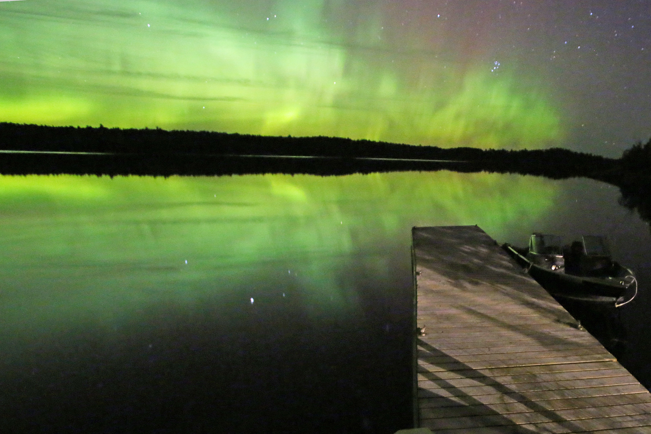
Voyageurs is an International Dark Sky Park. On clear nights, the Milky Way is a vivid smear across the sky. The real prize, however, is the aurora borealis. The park's northern latitude makes it one of the best places in the lower 48 to watch the Northern Lights. They are most frequent around the equinoxes, but can appear any time of year. Check aurora forecasts and be prepared for late nights.

Seasonal Realities and When to Visit
Your experience of Voyageurs National Park is entirely dictated by the season. The best time to visit depends entirely on what you want to do.
Summer (June-August)
This is the busy season. The frost-free period averages 120 days from June to mid-September. Daytime temperatures are mild, often in the 70s, but mosquitoes and black flies are a genuine factor from June into July. Pack bug spray with DEET. Water temperatures are swimmable by late July. This is the time for boating, paddling, and fishing. All visitor centers are open.
Fall (September-October)
Crowds vanish after Labor Day. September days can be perfect - crisp air, no bugs, and the start of fall color in the maple and aspen forests. By October, temperatures drop sharply. This is a superb time for solitude and photography, but be prepared for rapidly changing weather on the water. Some visitor centers reduce hours after September.
Winter (November-March)
The park is open 24/7, but services are minimal. This is the domain of snowmobilers, cross-country skiers, and ice anglers. The Echo Bay Trail is groomed for skiing, and the Oberholtzer Trail is ideal for snowshoeing. You can go sledding on Sphunge Island on Kabetogama Lake. The silence of a snow-covered forest here is profound. Check ice conditions relentlessly.
Spring (April-May)
"Mud season." The ice is melting or gone, but the water is frigid and the forests are damp. Trails can be muddy. This is the least popular time, but it offers a raw, transitional beauty and absolute solitude. The average ice-out date of May 3 is a local benchmark; before that, lake access is dangerous.

Practical Takeaways
- You Need a Boat Plan. Decide this first. Will you bring a motorboat, rent a pontoon, paddle a kayak, or join a tour? Your choice defines your trip. Make rental and tour reservations as early as possible.
- Target a Specific Lake. Don't just aim for "Voyageurs." Choose Rainy Lake for convenience and services, Kabetogama or Ash River for a quieter mid-lake start, or Crane Lake for remote exploration.
- Pack for the Water and the Bugs. Life jackets, nautical charts (or a GPS), rain gear, and sun protection are non-negotiable. So is insect repellent from June through July.
- Embrace the Off-Season. If you dislike crowds, visit after Labor Day. For a unique adventure, visit in winter when you can travel over the frozen lakes. Always check conditions with the visitor center first.
- Manage Distance Expectations. This park is vast. A day trip to a site like Anderson Bay involves significant boat time. Factor in travel hours when planning your days.
- Look Up at Night. Regardless of season, make time for stargazing. The dark sky here is a park resource as valuable as the lakes.
Final Thoughts
Voyageurs National Park asks more of you than most. It asks you to trade wheels for a hull, to read a lake chart instead of a road map, to consider the wind direction and the ice thickness. That investment is what makes the reward so distinct. It's the feeling of tying up at a rocky island for lunch, knowing you're the only people there. It's the sight of the northern lights reflecting in the still, black water of a sheltered bay. The park's history is one of journey - of voyageurs paddling loaded canoes. Your visit continues that tradition. You won't just see this landscape. You'll cross it.
Recommended Gear
What experienced visitors bring to Voyageurs National Park: Minnesota's Lake Country by Boat - 2026 Guide
Links may earn us a commission at no extra cost to you. We only recommend gear we believe in.
Hiking Essentials
Hydration Pack (3L)
Hands-free water for long trail days
Trekking Poles (Pair)
Save your knees on steep descents
Hiking Boots (Ankle Support)
Sturdy footwear for rocky, uneven trails
Sun & Heat Protection
Wide-Brim Sun Hat
Full coverage UPF 50+ protection at altitude
Insulated Water Bottle (32oz)
Keeps water cold in desert heat all day
Winter Gear
Microspikes / Traction Devices
Essential for icy rim trails in winter months
Packable Down Jacket
Lightweight warmth that stuffs into a pocket
Sources
- Official source: National Park Service nps.gov/thingstodo/sledding-on-sphunge-island.htm
- Official source: National Park Service nps.gov/voya/index.htm
Explore More National Parks

Isle Royale National Park: Wolf & Moose Wilderness Island - 2026 Guide
Discover wolf and moose wilderness on a remote Lake Superior island. Complete 2026 guide to Isle Roy...

Theodore Roosevelt National Park: Quiet Badlands Guide (2026)
Theodore Roosevelt National Park: North Dakota Badlands & Most first-time visitors to Theodore Roose...

Indiana Dunes National Park: Lake Michigan Dunes & Diverse Ecosystems - 2026 Guide
Discover Indiana Dunes National Park national park guide with our comprehensive guide. Expert tips,...

Badlands National Park: Fossil Beds & Painted Formations - 2026
These striking geologic deposits contain one of the world's richest fossil beds - ancient horses and...
Photo Gallery
More to Explore

Park Guide
Acadia National Park: Carriage Roads, Cadillac Mountain & 2026 Guide
Discover carriage roads, Cadillac Mountain, and rugged Maine coast. Complete 2026 guide to Acadia National Park — trails, fees, lodging, permits, and what rangers recommend.

Hiking Guide
Grand Canyon Hiking Trails: Day Hikes, Water Sources & Rim to Rim
Compare Grand Canyon hiking trails: Bright Angel, South Kaibab, Hermit, Grandview, and rim to rim, with distances, elevation, water stops, and trailhead access for each.

Best Of
Best of Glacier Bay National Park
The best of Glacier Bay is reached by boat: ranger-led day tours up the bay to the tidewater glaciers. What's worth it, how to book, and when to go (2026).

Campsite Guide
White Sands Backcountry Camping: Closed for 2026 — What to Know
As of 2026, backcountry camping at White Sands National Park is closed for site rehabilitation. What that means, and where to camp nearby instead.

Weather Guide
Guadalupe Mountains National Park Weather: Weather
Guadalupe Mountains National Park: weather guide guide updated 2026. Practical visitor information, reservations, and seasonal tips worth bookmarking before

Best Of
Best of Cuyahoga Valley National Park: Best Things to Do
Seeing a Cleveland Orchestra concert with the woods as your backdrop is a uniquely Cuyahoga Valley experience.
Sign in to join the conversation.
Sources & Attribution
Location data courtesy of the National Park Service (U.S. Department of the Interior). NPS data is public domain. Official NPS page.
Images: NPS; NPS; NPS; NPS; NPS.
Map data © OpenStreetMap contributors.
Park operations alerts: NPS.gov · Weather and weather hazards: National Weather Service · Live conditions.
Information may change. Always verify fees, hours, and conditions directly with the official source before visiting.
Did this guide help? Share it with a friend.