Most first-time visitors to Theodore Roosevelt National Park are caught off guard by how quiet it gets. Not the absence of sound-there's plenty of that, from the low rumble of bison in the tall grass to the scold of a black-billed magpie working a juniper-but the absence of crowds. This park sees a fraction of the traffic Yellowstone or Glacier do, even on a summer Saturday. For anyone looking for honest theodore roosevelt national park reviews, that fact comes up more than almost anything else. You share the badlands with maybe a hundred other people on a busy day, not a thousand.
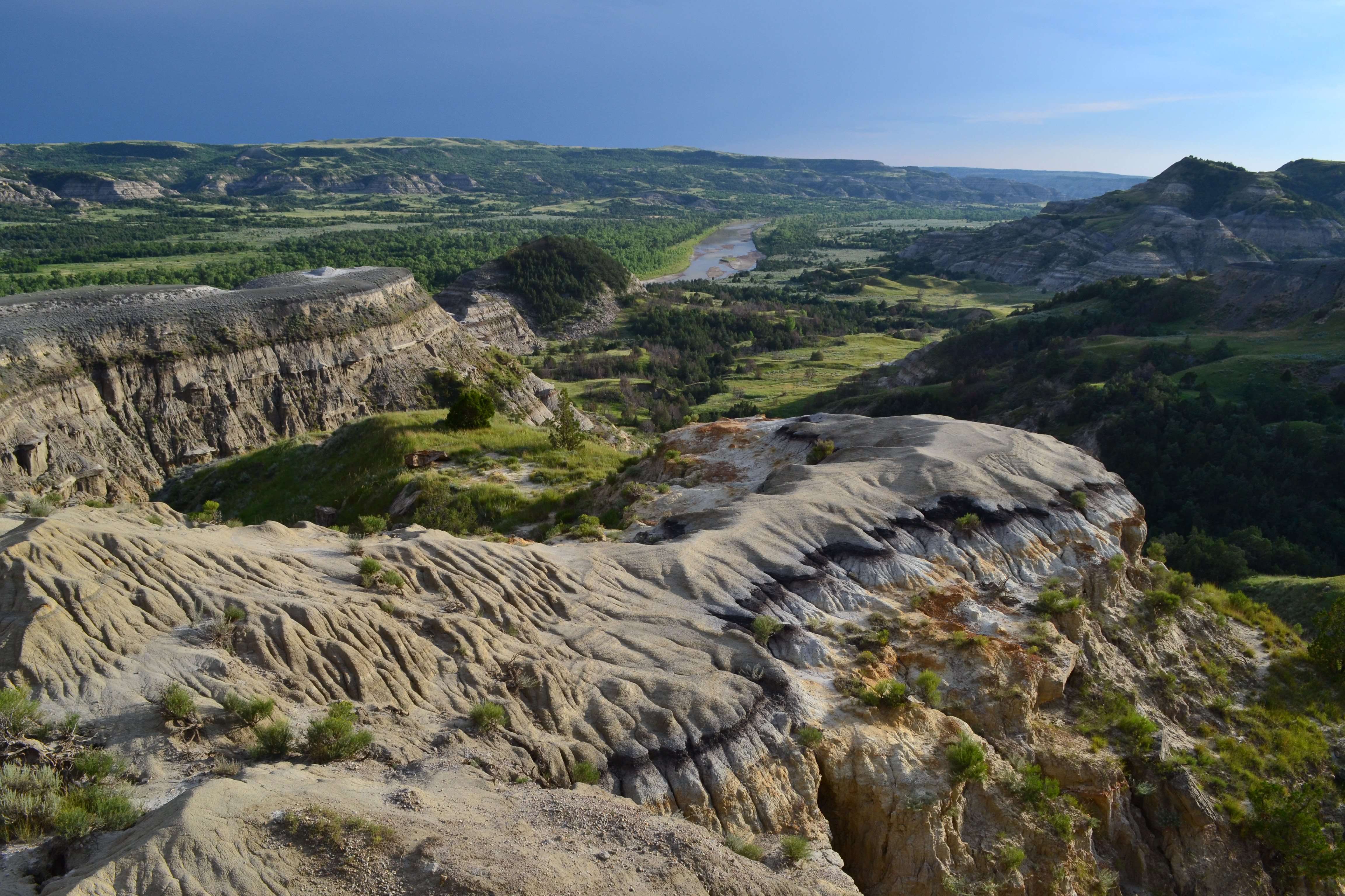
NPS Photo / Mark Meyers via NPS.gov (Public Domain)
Theodore Roosevelt National Park: Quiet Badlands Guide (2026)
12 min read
Park Guide
Theodore Roosevelt National Park spans 70,000 acres across three units, from the busy South Unit to the remote Elkhorn Ranch Unit.
Your plans
This article contains affiliate links — we may earn a small commission at no extra cost to you.
At a glance
Entrance Fee
Private vehicle $30 · Motorcycle $25 · Per person $15Full fee schedule
Hours
Theodore Roosevelt National Park is open 24 hours a day, every day of the year. This applies to all units of the park; N
Address
PO Box 7, Medora, ND, 58645
Website
47.1778, -103.4300
Google MapsThe park occupies three separate units in the North Dakota badlands, each with a distinct character and its own entrance. The South Unit sits right next to the town of Medora and gets the most traffic. The North Unit, about 70 miles up the road, is quieter still. And the Elkhorn Ranch Unit, accessible only by gravel roads, sees so few visitors that you may not see another person all day. That distribution of people across a landscape that covers 70,000 acres is what makes this park work.
For context on what is theodore roosevelt famous for, most people know the conservation legacy-that TR protected 230 million acres of public land during his presidency. Fewer know that it started here, in this specific stretch of badlands, when a young New Yorker in spectacles showed up in 1883 to shoot a bison and ended up having his life turned sideways by a place he couldn't shake. What is theodore roosevelt national park known for, if you ask the rangers, is that fact: this park preserves not just a landscape but the origin point of the entire conservation movement.
The Lay of the Land
The park breaks into three units that operate independently, and understanding the geography is the single most important planning decision you will make.
South Unit
The South Unit is the one most people picture when they think of Theodore Roosevelt National Park. It sits right off I-94 at Medora, exit 24 or 27. A 36-mile scenic drive loops through the unit, past prairie dog towns, bison herds, and overlooks that drop into the badlands. Most of the park's hiking trails are here, along with the visitor center, the campground, and the developed services. You can see the bulk of what the South Unit offers in a single day if you move efficiently, though you will wish you had two.
North Unit
The North Unit is 14 miles south of Watford City on Highway 85, about a 70-minute drive from the South Unit entrance. It has a 14-mile scenic drive that follows the Little Missouri River and offers a different perspective on the badlands-more sharply eroded, with deeper color in the rock layers. The North Unit has its own campground, a ranger station, and several solid trails. It gets maybe half the visitors the South Unit gets. If you want solitude, this is where you go.
Elkhorn Ranch Unit
The Elkhorn Ranch Unit sits between the other two units, accessible only by gravel roads. This is where TR actually ranched. There is no visitor center, no entrance station, no developed trails. A short loop walk takes you to the ranch site with interpretive signs. The road in is rough-washboard gravel, muddy when wet, and not advisable in a low-clearance vehicle after rain. The park service recommends consulting staff for directions before you go. This unit is for people who want to stand where TR stood and feel the isolation that shaped him. It is not for people in a hurry.
Driving Between Units
Plan on 90 minutes between the South Unit and North Unit, longer if you are towing or driving a large RV. The route is all paved on state and federal highways. The Elkhorn Ranch Unit adds significant time-washboard gravel roads at 25 mph for 20-plus miles, depending on which direction you approach from. Do not try to visit all three in one day. Pick one or two.
Planning Your Visit
Entrance Fees (as of 2026)
Theodore Roosevelt National Park charges entrance fees that apply to all three units. An entrance pass covers all units for seven days. As of May 2026, the park has moved to cashless fee collection-credit cards, debit cards, or digital payments only. No cash accepted.
- Private vehicle: $30.00
- Motorcycle: $25.00 (admits up to two motorcycles with up to four total passengers)
- Per person (walk-in, bike, horse): $15.00
- Commercial van (7-15 passengers): $50.00
- Commercial mini-bus (16-25 passengers): $60.00
- Commercial motor coach (26+ passengers): $150.00
The America the Beautiful Interagency Pass covers this park. If you visit multiple national parks in a year, the $80 annual pass pays for itself by your third visit.
Hours
The park is open 24 hours a day, 365 days a year. This applies to all three units. Even when entrance stations and visitor centers are closed, the park itself remains open. You can enter outside staffed hours-you just need to have already paid or display a valid pass. In winter, road closures due to snow can happen at any time. Check current conditions before heading out in November through March.
Best Time to Visit
The question of what was theodore roosevelt best known for gets answered differently depending on when you visit. Stand here in August and you will understand the heat that TR endured. Stand here in October and you will understand why he kept coming back.
May and June bring green grass and wildflowers, but also bugs and occasional rain. September and October are the sweet spot-cool mornings, warm afternoons, fewer people, no mosquitoes. July and August are hot-days above 90 are common, and there is limited shade on the trails. November through March means cold and potential road closures. The park is beautiful in winter but requires flexibility. Spring can be windy to the point of unpleasant.
See the full breakdown in our best time to visit guide.

Getting There & Getting Around
By Car
The South Unit entrance is in Medora, North Dakota, off I-94 exits 24 and 27. Medora sits about 30 miles west of Dickinson, the nearest town of any size, and 130 miles west of Bismarck. The North Unit entrance is on Highway 85, approximately 14 miles south of Watford City. Watford City is about 50 miles north of I-94 via Highway 85.
For mobile maps to the South Unit, use this address: 201 East River Road N, Medora, ND 58645. Standard GPS addresses for the park can be unreliable; this one works.
By Air
The nearest commercial airport is Dickinson (DIK), about 30 miles east of Medora. It has limited service-regional flights from Denver on United and from Minneapolis on Delta. Bismarck (BIS) is 130 miles east with more flight options. Williston (XWA) is 60 miles north of the North Unit with limited service. Most visitors drive in from wherever they flew into.
Parking Reality
The South Unit fills its parking lots on summer weekends, particularly at the visitor center and the trailheads for the popular hikes. The lot at the Coal Vein Trail and the Painted Canyon Visitor Center can overflow by 10 AM on a Saturday in July. The North Unit has more parking relative to its visitor count and rarely fills. The Elkhorn Ranch Unit has a small gravel lot that holds maybe a dozen cars.
Cell Service
Cell service drops out in the badlands. You can get a signal in Medora and Watford City, and spotty coverage on the ridges in the South Unit. The North Unit has essentially no service once you turn off Highway 85. Download maps and materials before you arrive. The NPS app works offline if you load the park content at home.
What to Do
Hiking
The hiking here is what brings most visitors back. The trails range from flat half-mile walks to eight-mile treks through eroded badlands. The trail surfaces are mostly packed dirt, gravel, and exposed sandstone-not groomed paths. You will get dirt on your shoes, and the footing demands attention on the steeper sections.
The Caprock Coulee Trail (4.5 miles loop) in the South Unit is the consensus favorite. It winds through a coulee, climbs to a ridgeline with wide views, and drops back through prairie. The Painted Canyon Trail (1 mile loop) is shorter but gives you an immediate sense of the badlands geology-color banding that looks like someone dripped paint across the rock. In the North Unit, the Achenbach Trail (3.5 miles one-way if you do the shuttle, 7 miles loop) is the best longer option, dropping into a drainage and following the Little Missouri River.
For a full breakdown, see our hiking trails guide. Pack extra water for this stretch-the badlands sun is relentless even on 70-degree days.
Scenic Driving
The South Unit's 36-mile Scenic Loop Drive is the standard introduction. It takes about 90 minutes without stops, but you will stop. Prairie dog towns at the start, bison along the middle section, and a half-dozen overlooks that force you out of the car. The North Unit's 14-mile Scenic Drive is shorter but arguably more dramatic-the badlands formations are more compressed and the colors more vivid in the afternoon light.
Wildlife Viewing
Bison are the main event. You will see them in both the North and South Units, often right on or near the road. Give them space-a bison that looks complacent can clear 35 mph in a sprint. The park's wild horse herd is smaller and harder to spot but present in the South Unit. Prairie dogs are everywhere in the South Unit, particularly along the first few miles of the scenic drive. Elk are more common in the North Unit, especially in the fall.
Theodore Roosevelt National Park is known for having all the species that TR would have seen in the 1880s-bison, elk, pronghorn, bighorn sheep, wild horses-plus the occasional mountain lion (rare, but present). Birders will pick up golden eagles, prairie falcons, and the occasional ferruginous hawk. Early morning is your best bet for seeing most mammals. Midday is for birds of prey riding thermals.
See our wildlife viewing guide for species-specific advice.
Stargazing
The park is a designated International Dark Sky Park. The Milky Way is visible to the naked eye on moonless nights, and the lack of light pollution means you see more stars than most visitors have ever seen. The North Unit is darker than the South Unit, but both are excellent. The best stargazing is between an hour after sunset and midnight, and again in the early morning hours before dawn.
Junior Ranger Program
If you are traveling with kids, the Junior Ranger program here is well-designed. It takes about two hours to complete the activities, and the badge is a legitimately good one. Pick up a booklet at either visitor center.

Where to Stay
Inside the Park
The South Unit has one campground-Cottonwood Campground-with both tent and RV sites. It operates on a first-come, first-served basis. No reservations, which means summer weekends fill by early afternoon. The North Unit has a smaller campground, Juniper Campground, also first-come, first-served. Both have flush toilets and drinking water in season. Neither has hookups.
There is no lodging inside the park. No lodges, no cabins, no yurts. If you want a roof and four walls, you stay in Medora or Watford City.
For full specifics on sites, fees, and strategies for getting a spot, see our camping options guide.
Medora
Medora is the gateway town for the South Unit, and it leans hard into the TR theme. It has a handful of motels, a few bed-and-breakfasts, and an RV park. In summer, Medora fills up. Book months ahead if you want a room in July or August. The town also has the Medora Musical, a summer theater production about TR's life. It is the kind of thing you either love or avoid, but it exists.
Watford City
Watford City serves the North Unit with a few chain hotels and a couple of local motels. It is less touristy than Medora and cheaper. It also has an RV park and a few restaurants. For RV camping near theodore roosevelt national park, Watford City is the practical base for the North Unit. For free camping near theodore roosevelt national park, dispersed camping is available in the Little Missouri National Grassland adjacent to the park-check with the ranger station for current areas.
For a full list of options, see our lodging and accommodations guide.
Seasonal Guide
Spring (April - May)
Temperatures range from 40 to 65 degrees. The grass turns green, wildflowers start blooming, and the prairie dogs are active. Wind is a constant companion-20 mph gusts are normal. Trails can be muddy. Fewer visitors than summer. Road closures possible in April if snow lingers.
Summer (June - August)
This is the busiest season, though "busiest" here still means modest crowds. Daytime highs from 80 to 95 degrees. Afternoon thunderstorms are common. Bring more water than you think you need. The scenic drives fill up by mid-morning on weekends. Bison are active in the cooler parts of the day and bed down in the heat. The sun is intense-there is almost no shade on the trails. Sunscreen and a wide-brimmed hat should be non-negotiable.
Fall (September - October)
The best time to visit. Daytime highs from 60 to 75 degrees. The cottonwoods along the river turn yellow. The crowds thin dramatically after Labor Day. Bison are active throughout the day. Elk bugle in September in the North Unit. No bugs. The light in October is warm and low and makes the badlands glow. Road closures are rare until November.
Winter (November - March)
Cold. Daytime highs from 10 to 35 degrees. Snowfall is moderate but wind drifts can close roads. The park stays open, but some roads may close without notice. You might have the place almost entirely to yourself. Winter hiking is possible with proper gear-crampons help on packed snow. The visitor centers operate on reduced hours. Check conditions before driving out.

Practical Takeaways
- The park is cashless as of May 2026. Bring a credit or debit card. Do not plan on paying entrance fees or campground fees with cash.
- The South Unit scenic loop takes longer than you expect. Every overlook pulls you out of the car. Budget two to three hours minimum if you want to actually stop and look.
- The North Unit is not a drive-through on the way to something else. It is 70 miles from the South Unit, and the road access is separate. It is its own destination. Do not try to do both units in a half-day.
- The trails have almost no shade. A hat, sunscreen, and at least one liter of water per hour of hiking are not optional. The park service emphasizes this because people underestimate it every summer.
- Bison are not tame. You see them on the side of the road and they look placid, but they can and will charge if crowded. Park regulations require you to stay at least 25 yards away. Use a zoom lens, not your feet.
- Cell service drops out in the badlands. Download offline maps, the NPS app, and any driving directions before you leave Medora or Watford City. The Petrified Forest Trailhead in the South Unit requires specific directions that you should have saved offline.
- Petrified Forest Trailhead access has changed. As of this writing, use the approved route from I-94 Exit 10 toward Camels Hump Lake and follow the marked posts. Do not follow old GPS directions to this trailhead.
- The Elkhorn Ranch Unit is a gravel road commitment. The road is washboard, slow, and can become impassable when wet. Do not take a low-clearance vehicle. Do not go without checking road conditions first.
- Campgrounds are first-come, first-served. There is no reservation system for Cottonwood or Juniper Campgrounds. Arrive before noon in summer to secure a site, or have a backup plan in Medora or Watford City.
- Rangers genuinely know the park. Stop at the visitor center and ask what conditions are like on the trail you plan to hike. The rangers here have been catching the same questions for years and will give you straight answers about what is worth your time.
Final Thoughts
Theodore Roosevelt National Park is for people who want to see what the northern plains looked like before fences and center-pivot irrigation. It is for people who can handle a little wind, a little heat, and a trail that does not hold your hand. The park does not offer luxury, it does not offer convenience, and it does not offer the spectacle of the marquee national parks out west. What it offers is a landscape that changed the course of American conservation, and the quiet to sit with that fact.
If you come expecting Yellowstone-scale drama, you will be disappointed. If you come expecting to stand in the same badlands that turned a young politician into a lifelong conservationist, you will leave understanding exactly why he wrote that he never would have been president if not for his time in the Dakota Territory. That is what this park gives you, and it gives it without a crowd.
For more information, see our complete National Park Guide.
Related: what was theodore roosevelt best known for guide
Related: hiking in theodore roosevelt national park guide
Recommended Gear
What experienced visitors bring to Theodore Roosevelt National Park: Quiet Badlands Guide (2026)
Links may earn us a commission at no extra cost to you. We only recommend gear we believe in.
Hiking Essentials
Hydration Pack (3L)
Hands-free water for long trail days
Trekking Poles (Pair)
Save your knees on steep descents
Hiking Boots (Ankle Support)
Sturdy footwear for rocky, uneven trails
Sun & Heat Protection
Wide-Brim Sun Hat
Full coverage UPF 50+ protection at altitude
Insulated Water Bottle (32oz)
Keeps water cold in desert heat all day
Winter Gear
Microspikes / Traction Devices
Essential for icy rim trails in winter months
Packable Down Jacket
Lightweight warmth that stuffs into a pocket
Sources
- Official source: NPS — Theodore Roosevelt National Park nps.gov/thro/index.htm
Explore More National Parks

Badlands National Park: Fossil Beds & Painted Formations - 2026
These striking geologic deposits contain one of the world's richest fossil beds - ancient horses and...

Wind Cave National Park: The World's Densest Cave System - 2026 Guide
Discover the world's densest cave system and rare boxwork formations. Complete 2026 guide to Wind Ca...

Yellowstone National Park: Geysers, Wildlife & Complete 2026 Visitor Guide
Complete guide to yellowstone national park on map. Everything you need to know, updated for 2026.

Grand Teton National Park: Complete Guide (2026)
That abrupt, sky-scraping wall defines Grand Teton National Park. A straightforward hike to a beauti...
Photo Gallery
More to Explore

Park Guide
Acadia National Park: Carriage Roads, Cadillac Mountain & 2026 Guide
Discover carriage roads, Cadillac Mountain, and rugged Maine coast. Complete 2026 guide to Acadia National Park — trails, fees, lodging, permits, and what rangers recommend.

Hiking Guide
Grand Canyon Hiking Trails: Day Hikes, Water Sources & Rim to Rim
Compare Grand Canyon hiking trails: Bright Angel, South Kaibab, Hermit, Grandview, and rim to rim, with distances, elevation, water stops, and trailhead access for each.

Best Of
Best of Glacier Bay National Park
The best of Glacier Bay is reached by boat: ranger-led day tours up the bay to the tidewater glaciers. What's worth it, how to book, and when to go (2026).

Campsite Guide
White Sands Backcountry Camping: Closed for 2026 — What to Know
As of 2026, backcountry camping at White Sands National Park is closed for site rehabilitation. What that means, and where to camp nearby instead.

Weather Guide
Guadalupe Mountains National Park Weather: Weather
Guadalupe Mountains National Park: weather guide guide updated 2026. Practical visitor information, reservations, and seasonal tips worth bookmarking before

Best Of
Best of Cuyahoga Valley National Park: Best Things to Do
Seeing a Cleveland Orchestra concert with the woods as your backdrop is a uniquely Cuyahoga Valley experience.
Sign in to join the conversation.
Sources & Attribution
Location data courtesy of the National Park Service (U.S. Department of the Interior). NPS data is public domain. Official NPS page.
Images: NPS Photo / Mark Meyers; NPS Photo / Laura Thomas; NPS Photo / Laura Thomas; NPS Photo / Teresina Wheaten; NPS Photo / Jeff Zylland.
Map data © OpenStreetMap contributors.
Park operations alerts: NPS.gov · Weather and weather hazards: National Weather Service · Live conditions.
Information may change. Always verify fees, hours, and conditions directly with the official source before visiting.
Did this guide help? Share it with a friend.