For more, see hiking trails.
NPS Photo via NPS.gov (Public Domain)
Kobuk Valley National Park: Arctic Sand Dunes & Caribou - 2026 Guide
7 min read
Park Guide
Kobuk Valley National Park offers Arctic sand dunes and a 9,000-year-old caribou migration, reachable only by chartered air taxi from Kotzebue or Bettles.
Your plans
This article contains affiliate links — we may earn a small commission at no extra cost to you.
At a glance
Hours
The Northwest Arctic Heritage Center is the visitor center for Kobuk Valley National Park. Since there are no roads in
Address
171 3rd Ave, Kotzebue, AK, 99752
Website
67.3563, -159.2002
Google MapsIntroduction
Kobuk Valley National Park has no entrance station, no paved roads, and no cell service. What it does have is a caribou migration that has crossed the same river ford for nine thousand years, and a set of active sand dunes that shift under the Arctic sun. This is not a park you drive through. Getting there requires multiple flights and a budget that reflects it. This guide covers the logistics of reaching the park, what to expect from the landscape and wildlife, and how to plan a trip where the visitor center is in a different town than the park itself.

The Logistics of Getting to Nowhere
The first thing to understand is that your trip begins in an airport, not at a park gate. The Northwest Arctic Heritage Center, the park's visitor center, is located at 171 3rd Ave in Kotzebue, Alaska. The actual park is about a hundred air miles northeast. There are no roads connecting them. None.
You will fly commercially from Anchorage to Kotzebue, or from Fairbanks to the smaller hub of Bettles. From there, you charter an air taxi - a small plane - to take you into the park boundary. This is non-negotiable. The cost is significant and varies by operator, aircraft type, and drop-off location. Rangers at the visitor center maintain a list of authorized air taxi services; you'll want to contact several for quotes as part of your planning. The park itself is open 24/7, year-round, but your access is entirely dictated by weather and pilot availability.
Most visitors underestimate two things: the weight limit for these charter flights (often strict, around 50-75 pounds per person including gear) and the absolute necessity of a flexible schedule. Fog, high winds, or low visibility can ground small planes for days. Build in buffer days on both ends of your trip. Your return flight from Kotzebue back to Anchorage should not be scheduled for the day after your planned pick-up from the backcountry.

Understanding the Arctic Environment
The weather note on the park's website is not a suggestion. It reads: "Snow, rain, and freezing temperatures can occur any time of the year." In practice, this means a sunny July afternoon can turn into a cold, driving rainstorm in under an hour. The temperature drop is rapid. Hypothermia is a genuine risk on a windy, wet day, even when the air temperature reads above freezing.
Your gear list is your first line of defense. Good quality rain gear - a waterproof and breathable jacket and pants - is more important than a fancy tent. Warm layers, like fleece or wool, that retain heat when wet are essential. Cotton is useless here; once wet, it saps body heat. The goal is to stay dry from both external precipitation and internal sweat. You'll be managing layers constantly: stripping down while hiking to avoid sweating, then adding them back the moment you stop.
Summer temperatures (June through August) might range from the 40s to the 70s Fahrenheit, but always plan for the lower end. Mosquitoes can be prolific in July, so a head net and repellent are wise investments. By late August, the tundra begins to turn, frosts are common, and the bug pressure eases. For specific seasonal details, our guide on the best time to visit breaks it down further.

The Heart of the Park: Dunes, River, and Caribou
Once your plane's skis touch down on a gravel bar or its wheels roll to a stop on a tundra strip, the reality of the place sets in. The silence is immense, broken only by wind, water, or the distant drone of your departing plane. Your activities are defined by the park's three core features: the Great Kobuk Sand Dunes, the Kobuk River, and the Western Arctic Caribou Herd.
The Great Kobuk Sand Dunes
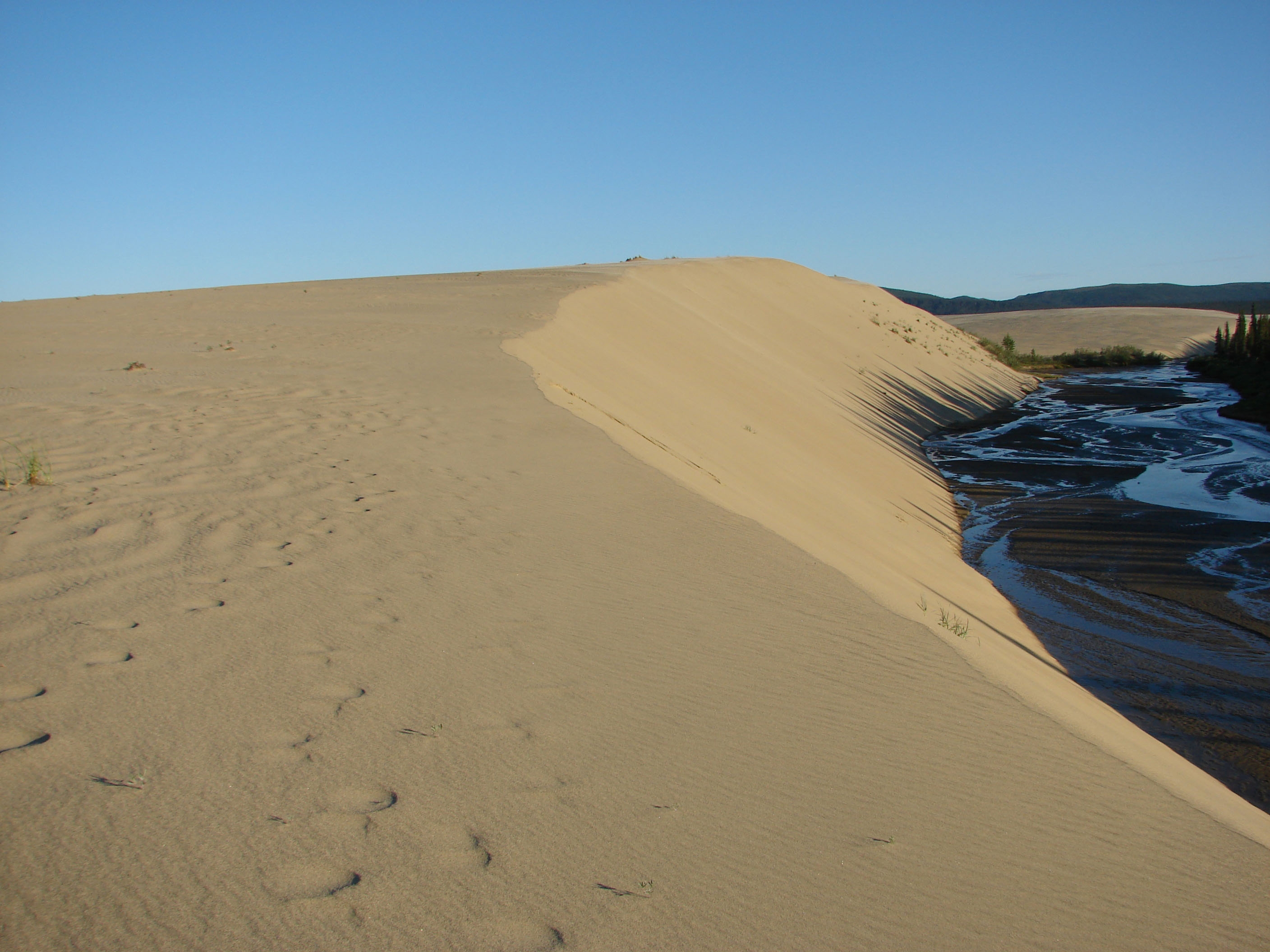
This is the anomaly - 25 square miles of active sand dunes just 35 miles north of the Arctic Circle. They are not towering like Saharan dunes, but rather a rolling, sculpted landscape of sand ridges and blowouts. Hiking them is strenuous; your feet sink with each step and the sand reflects heat on sunny days. There are no marked trails. Navigation is by map, compass, and GPS (with extra batteries). The reward is a surreal, silent landscape where you can find the tracks of caribou, wolves, and foxes etched into the sand. From the high dune ridges, you look out over a seemingly infinite expanse of green tundra and spruce forest, a contrast that defines this place.
The Kobuk River Corridor
The Kobuk River is the park's highway. For millennia, it has been a travel corridor for people and wildlife. Today, it's the most practical way for visitors to cover distance. Paddling is the primary mode of travel. You can arrange for an air taxi to drop you with a canoe or kayak at one point and pick you up days later downstream. The current is generally gentle, but the river is wide, cold, and braided with shifting sandbars. Wind coming up the channel can create challenging paddling conditions or pin you to shore for hours. Every bend offers a new vista of sand bluffs and spruce forests. This is also the heart of the park's fishing opportunities for sheefish, arctic grayling, and northern pike.
The Caribou Migration at Onion Portage
This is why people have come here for nine thousand years. The Western Arctic Caribou Herd, numbering in the hundreds of thousands, migrates through the park twice a year. In late August and September, they swim across the Kobuk River at a place called Onion Portage during their southward trek. It's one of the most consistent wildlife migrations on the continent.
Witnessing it is a matter of extreme timing, patience, and luck. You need to be in the right place (a camp near the portage) at the exact right week, as the migration window can shift with weather and animal behavior. Even if you miss the main river crossing, you'll see their tracks everywhere - networks of trails pressed into the tundra and sand that look like well-worn footpaths. For a deeper focus on this phenomenon, see our dedicated wildlife viewing resource.

Planning Your Time on the Ground
With no infrastructure, you are completely self-sufficient. Your trip will fall into one of two categories: a basecamp experience or a river-moving trip.
Basecamping involves having your air taxi drop you at a specific location, like near the dunes or a known caribou observation point, and returning to pick you up from the same spot days later. This allows for deep exploration of one area without the burden of breaking camp daily. It's ideal for photography, day hiking trails (such as they are in this trailless wilderness), and waiting for wildlife.
River Trips are for covering ground. A typical route might involve a drop-off at Walker Lake and a 5-7 day paddle down to the take-out at the village of Kiana (which requires prior coordination and permissions). This style offers changing scenery and a true sense of journey. You must be proficient in reading river currents, managing loaded boats, and understanding that your planned take-out spot might be altered by weather, preventing your pilot from landing.
All trips are backcountry camping. There are no designated sites, just the rule of thumb to camp on durable surfaces like gravel bars or sand well away from vegetation. Use a bear-resistant food container. Practice Leave No Trace principles religiously - this landscape recovers slowly. All the details on permits, bear safety, and site selection are in our camping options guide.
Given the complexity, many visitors opt for structured tours and guided experiences. A reputable guide service handles the air charters, provides gear, knows the river conditions, and increases your odds of being in position for wildlife events. It's a costly but often worthwhile option for a first-time visit.
Practical Takeaways
- Start with the Air Taxi. Your first planning call shouldn't be to an airline, it should be to a Kobuk Valley air taxi operator. They will tell you realistic costs, weight limits, and current landing conditions. They are your logistical linchpin.
- Pack for Wet Cold. Your rain jacket is your most important piece of clothing. Follow it with synthetic or wool insulating layers, waterproof boots, and multiple pairs of socks. Test your gear in cold, wet conditions at home before you go.
- Embrace the Weight Limit. Packing for a week under 50 pounds is a skill. Weigh every item. Share community gear (tent, stove, bear canister) with your group. Every ounce you save is an ounce of food or camera gear you can bring.
- Schedule for Weather Delays. Book refundable or changeable commercial flights to and from Kotzebue. Leave at least two full buffer days between your planned backcountry pick-up and your flight out of Alaska. Getting weathered in is normal, not an emergency.
- Get Your Bearings Literally. You must know how to navigate with a topographic map and compass. GPS is a helpful tool, but batteries die and screens fail. Practice before your trip.
- Visit the Heritage Center First. Even though it's in Kotzebue, stop at the Northwest Arctic Heritage Center. Talk to the rangers. Get the latest on river conditions, caribou movement reports, and any local advisories. They have the most current, on-the-ground intelligence.
Final Thoughts
Kobuk Valley National Park resists the standard national park checklist. You cannot collect a stamp and drive to an overlook. Its value is measured in effort and stillness. The cost and complexity act as a filter, ensuring that those who make it are prepared for an environment that has not been softened for consumption. You go to feel the grit of Arctic sand underfoot, to watch a river that has carved time into bluffs, and to stand in a place where human history is measured in millennia, not decades. It's a reminder that some parts of the map are still meant to be empty, and that getting to them should never be easy. Check the official park website for the latest air taxi lists and contact information, then start planning for the quiet.
Recommended Gear
What experienced visitors bring to Kobuk Valley National Park: Arctic Sand Dunes & Caribou - 2026 Guide
Links may earn us a commission at no extra cost to you. We only recommend gear we believe in.
Hiking Essentials
Hydration Pack (3L)
Hands-free water for long trail days
Trekking Poles (Pair)
Save your knees on steep descents
Hiking Boots (Ankle Support)
Sturdy footwear for rocky, uneven trails
Sun & Heat Protection
Wide-Brim Sun Hat
Full coverage UPF 50+ protection at altitude
Insulated Water Bottle (32oz)
Keeps water cold in desert heat all day
Electrolyte Mix Packets
Replace what water alone cannot during intense heat
Winter Gear
Microspikes / Traction Devices
Essential for icy rim trails in winter months
Packable Down Jacket
Lightweight warmth that stuffs into a pocket
Sources
- Official source: NPS — Kobuk Valley National Park nps.gov/kova/index.htm
Explore More National Parks

Gates of the Arctic National Park: Complete Guide (2026)
Gates of the Arctic National Park, America's northernmost park, has no roads or trails. Reach it by...

Denali National Park: North America's Highest Peak - 2026 Visitor Guide
Denali National Park centers on a single park road into Alaska Range tundra and wildlife habitat, wh...

Lake Clark National Park: Wild Alaska by Floatplane - 2026 Visitor Guide
Discover Lake Clark National Park national park guide with our comprehensive guide. Expert tips, pra...

Kenai Fjords National Park: Tidewater Glaciers & Marine Wildlife — 2026 Guide
Discover kenai fjords national park how to get there with our comprehensive guide. Expert tips, prac...
Photo Gallery
More to Explore

Park Guide
Acadia National Park: Carriage Roads, Cadillac Mountain & 2026 Guide
Discover carriage roads, Cadillac Mountain, and rugged Maine coast. Complete 2026 guide to Acadia National Park — trails, fees, lodging, permits, and what rangers recommend.

Hiking Guide
Grand Canyon Hiking Trails: Day Hikes, Water Sources & Rim to Rim
Compare Grand Canyon hiking trails: Bright Angel, South Kaibab, Hermit, Grandview, and rim to rim, with distances, elevation, water stops, and trailhead access for each.

Best Of
Best of Glacier Bay National Park
The best of Glacier Bay is reached by boat: ranger-led day tours up the bay to the tidewater glaciers. What's worth it, how to book, and when to go (2026).

Campsite Guide
White Sands Backcountry Camping: Closed for 2026 — What to Know
As of 2026, backcountry camping at White Sands National Park is closed for site rehabilitation. What that means, and where to camp nearby instead.

Weather Guide
Guadalupe Mountains National Park Weather: Weather
Guadalupe Mountains National Park: weather guide guide updated 2026. Practical visitor information, reservations, and seasonal tips worth bookmarking before

Best Of
Best of Cuyahoga Valley National Park: Best Things to Do
Seeing a Cleveland Orchestra concert with the woods as your backdrop is a uniquely Cuyahoga Valley experience.
Sign in to join the conversation.
Sources & Attribution
Location data courtesy of the National Park Service (U.S. Department of the Interior). NPS data is public domain. Official NPS page.
Images: NPS Photo; NPS Photo / Justine Schmidt; NPS Photo; NPS Photo / Annie Carlson; NPS Photo.
Map data © OpenStreetMap contributors.
Park operations alerts: NPS.gov · Weather and weather hazards: National Weather Service · Live conditions.
Information may change. Always verify fees, hours, and conditions directly with the official source before visiting.
Did this guide help? Share it with a friend.