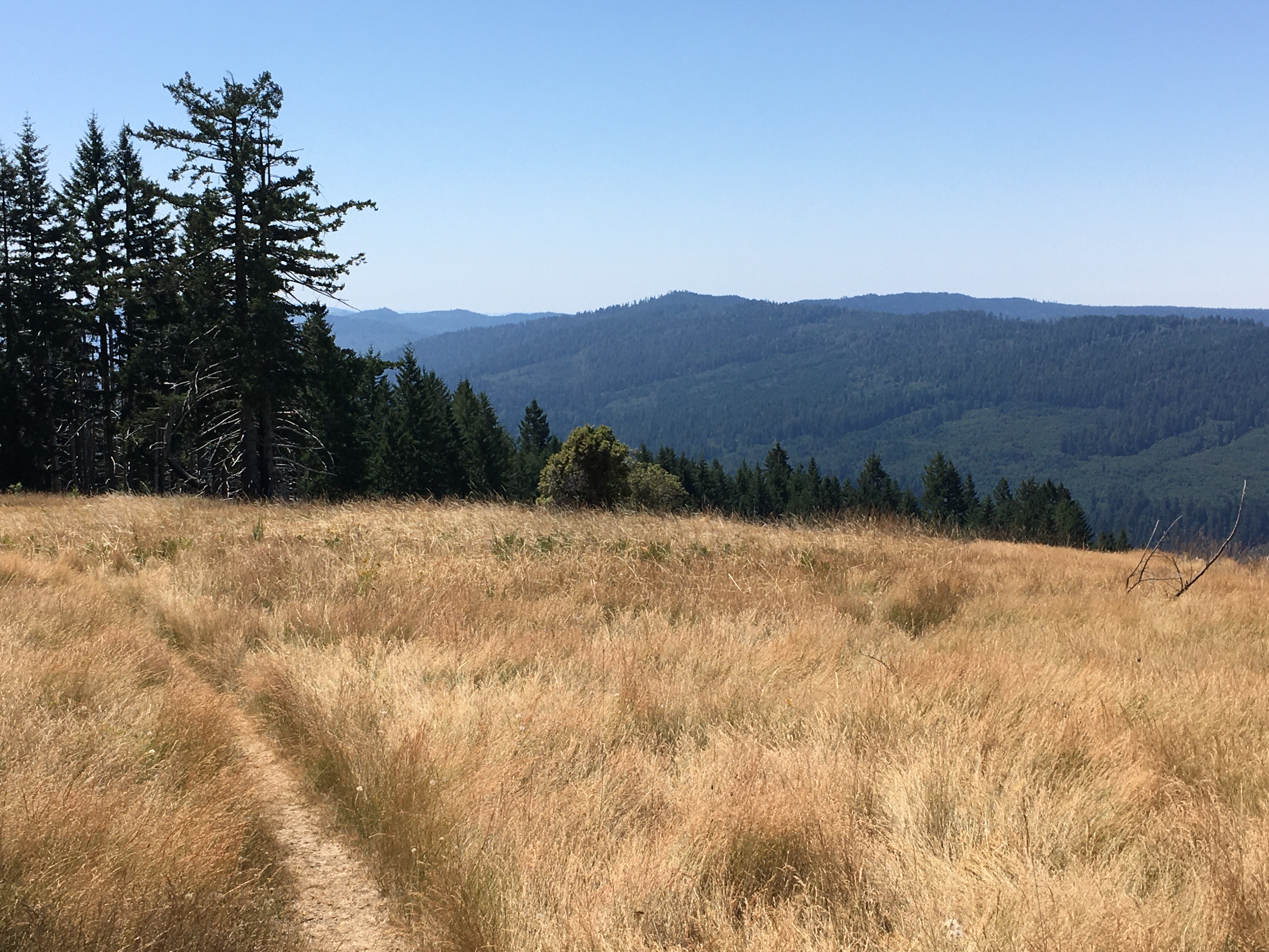
The quiet up here is different. Not the dense, damp hush of the redwood groves below, but the expansive, wind-scoured silence of a high meadow. The air carries the scent of dry grass and sun-baked earth. This is the trailhead for the Dolason Prairie Trail, a ten-mile point-to-point route that doesn't merely pass through the redwoods—it descends into them from the ridgeline. It's a hiker's trail, trading crowded, flat loops for a rugged drop from the Bald Hills prairies into the deep trough of Redwood Creek. Many visitors don't grasp the commitment. The park service marks it as a trailhead, but seasoned hikers recognize it as a full-day undertaking that reveals two distinct aspects of Redwood National and State Parks.
NPS via NPS.gov (Public Domain)
Dolason Prairie Trail
9 min read
Places & Points of Interest
Discover Dolason Prairie Trail: dolason prairie trail with our comprehensive guide. Expert tips, practical information, and insider knowledge.
Your plans
Overview
The Dolason Prairie Trail demonstrates a clear vertical progression. It starts around 3,200 feet on the open, rolling grasslands of the Bald Hills—terrain that feels more like Montana than the Northern California coast. The trailhead, as of 2026, offers basic amenities: a small parking pullout, a vault toilet, an information kiosk, a picnic table, and a trash receptacle. You won't find redwoods here. You begin under a broad sky, with westward views to the Pacific on clear days. The trail drops over 2,800 feet along its course, passing through Douglas-fir and tan oak zones before reaching the ancient coast redwoods along Redwood Creek. It's not a loop; it requires a shuttle or a strenuous out-and-back, so planning is key. Rangers note it's among the least traveled major trails in the parks, largely because it demands more effort.
Quick Information
* Entrance Fee: Redwood National and State Parks do not charge an entrance fee. Some state park campgrounds have nightly fees.
* Hours: The trail is accessible year-round, but the Bald Hills Road leading to the trailhead is subject to seasonal closures due to snow, typically from late fall through early spring. Check road status before you go.
* Best Time to Visit: Late spring (May-June) for prairie wildflowers and manageable temperatures, or early fall (September-October) for stable weather and clear skies. Summer can be hot and dry on the exposed upper sections.
* Location: Northern California, within Redwood National Park. The trailhead is located on Bald Hills Road, approximately 10 miles east of Highway 101 near Orick.
* Accessibility: The trail is not wheelchair or stroller accessible. It is a steep, rugged, natural surface trail.
* Cell Service: Unreliable. Expect no service for most of the hike, especially in the Redwood Creek canyon. Do not rely on your phone for navigation or emergencies.
* Restrooms: One vault toilet at the trailhead. No facilities anywhere else on the trail.
* Parking: A small, unpaved pullout for about 8-10 vehicles. It rarely fills completely except on peak summer weekends. Do not block the gate.

Getting There
You'll find the trailhead off Bald Hills Road, a scenic drive that climbs into the park's eastern high country. From Highway 101 near Orick, look for the signed turn onto Bald Hills Road just north of the Thomas H. Kuchel Visitor Center. Drive east for about 10 miles. The road is paved but narrow and winding, climbing steadily. RVs and trailers are not recommended. The trailhead will be on your left (north) side, marked by a small sign and a gate. There's no developed parking lot, just a widened area of gravel and dirt. The drive from Orick takes about 25-30 minutes. Your GPS will try to guide you; ignore it if it suggests any route other than Bald Hills Road from 101. The coordinates are for reference, but the road signs are reliable.
What to Expect
Expect a trail of distinct chapters. The first mile traverses the open Dolason Prairie. The path is a worn groove in the golden grass, with a steady, moderate descent. The sun is direct here, and the wind is a constant presence. Watch for hawks circling overhead and listen for the buzz of insects in the summer. After about 1.5 miles, you enter the forest edge - first Douglas-fir and madrone, with filtered light. The trail narrows here, becoming a proper dirt singletrack.
The middle section is where the real descent begins. The trail enters a series of long, sometimes steep switchbacks through dense second-growth forest. The soil is often a fine, dark duff that can be slick when dry and muddy when wet. Trekking poles are highly recommended for knee preservation on the downhill and for aid on the return climb. You'll hear Redwood Creek long before you see it - a distant, muffled roar during spring runoff, a quieter murmur in late summer.
The final chapter is the reward: the floor of the Redwood Creek valley. The air becomes noticeably cooler and damper. The trees grow larger, shifting from fir to the colossal coast redwoods. You'll end at a junction near the creek, surrounded by the deep quiet and filtered green light of the old-growth forest. The common mistake is underestimating the return trip. What took 2.5 hours to descend can take 4 or more to climb back out, with over 2,800 feet of elevation gain waiting for you.

Top Attractions & Points of Interest
The Prairie Start
The trailhead itself is an attraction. The 360-degree views from the Bald Hills are some of the most expansive in the park system. On a clear day, you can see the blue line of the Pacific Ocean to the west and the rumpled, forested ridges of the park interior to the east. It's a completely different ecosystem from the redwood groves, home to elk, deer, and a variety of grassland birds. Spend a few minutes here to acclimate to the scale.
The Forest Transition Zone
About two miles in, the trail makes a definitive shift from open slope to enclosed forest. This ecotone is a good place to notice the change in temperature, sound, and light. It's also where you'll find some of the best late-spring wildflowers like lupine and columbine along the trail edges before the canopy closes in completely.
Redwood Creek Confluence
The end of the Dolason Prairie Trail is not a dramatic terminus, but a quiet junction near the banks of Redwood Creek. This is the heart of the park's backcountry. The air is cool and still. This is your turnaround point for an out-and-back, or the start of a longer adventure connecting to the Tall Trees Grove or other backcountry camps. The sound of the creek is the dominant feature here.
Activities
Hiking
This is the primary activity. The Dolason Prairie Trail is a serious hike. It can be done as a punishing 10-mile out-and-back (descending first, climbing back to your car), or as a one-way shuttle hike if you have a second vehicle or can arrange a pickup at a lower trailhead like the Tall Trees access. The latter requires planning and a free permit for the Tall Trees area. For most, the out-and-back to Redwood Creek and back is a full 6-8 hour day. It's a trail for those who have already experienced the park's easier loops and want solitude and a physical challenge.
Photography
The photographic opportunities shift dramatically. The prairie start offers sweeping landscape shots, especially at sunrise or sunset. The middle forest section has intimate details - fern-covered slopes, shafts of light through the canopy. The bottom is classic redwood photography: towering trunks, creek scenes, and dense green light. Bring a lens cloth; the transition from dry prairie dust to damp creek air will fog your lens.
Wildlife Viewing
Each zone has its specialists. The prairie is for elk and raptors. The forest edges are good for black-tailed deer and varied thrushes. The deep creek canyon is where you might hear (but rarely see) the endangered marbled murrelet, or spot signs of black bear. For more focused advice, our guide to wildlife viewing in the redwoods covers what to look for and how to behave.

Seasonal Guide
* Spring (April-June): The best overall season. The prairie is green and dotted with wildflowers. Redwood Creek runs high and loud. Temperatures are cool to mild. Bald Hills Road is usually open by late April. Mosquitoes can be present in the lower canyon.
* Summer (July-August): The prairie section turns golden-brown and can be hot, with temperatures in the 80s (°F). Start early. The creek flow diminishes to a trickle. This is the most reliable time for clear skies and the busiest season for the trailhead parking.
* Fall (September-October): A close second to spring. Cool, stable weather returns. The first rains dampen the dust on the trail. Fall colors appear in the maple and tan oak understory. An excellent time for a strenuous day hike.
* Winter (November-March): Bald Hills Road is often closed due to snow and mud at higher elevations, making the trailhead inaccessible. Even if the road is open, the trail can be extremely muddy, slick, and cold. Not recommended unless you are prepared for winter mountaineering conditions.
Practical Information
No fees or permits are required to day-hike the Dolason Prairie Trail. However, if you plan to connect from the bottom of the trail to the Tall Trees Grove, you must obtain a free online reservation for the Tall Trees Trailhead access road. This is a separate process. Overnight trips require a free backcountry permit, available at park visitor centers.
For camping options, the nearest drive-in campgrounds are Elk Prairie or Mill Creek, both about a 45-minute drive from the trailhead via Bald Hills Road and Highway 101. For lodging and accommodations, the towns of Orick (closest), Trinidad, and Crescent City offer motels and vacation rentals. There are no services, water, or food available on Bald Hills Road. Fill your tank and your water bottles in Orick.

Safety & Preparation
Your safety hinges on preparation. This is a remote trail.
* Water: There is no potable water. Carry all you will need for the entire hike - a minimum of 3-4 liters per person. You can filter water from Redwood Creek at the bottom, but you must treat it.
* Navigation: The trail is well-defined but unsigned after the start. Carry a physical map and know your turnaround point. GPS devices can fail under the dense canopy.
* Weather: Conditions change drastically from top to bottom. The prairie can be sunny and warm while the creek canyon is cool and foggy. Dress in layers, including a wind/rain shell. Check the forecast for the Bald Hills area specifically.
* Physical Condition: The climb out is strenuous. Honestly assess your fitness. Turning around partway down is a perfectly respectable choice.
* Wildlife: Roosevelt elk are common on the prairie. Give them a wide berth, especially during calving season (spring). Black bears are present but avoid people; store any food properly.
* Emergency: Tell someone your plan. Cell service is absent. The nearest ranger station is the Thomas H. Kuchel Visitor Center in Orick.
Insider Tips
- The Early Bite: Start hiking by 8 AM. This gives you cooler temperatures for the exposed climb back out and maximizes your chances of finishing before dark.
- Pole Position: Trekking poles aren't just for the elderly. On this trail, they'll save your knees on the descent and provide critical propulsion on the ascent. Most first-time visitors who skip them regret it by mile seven.
- The Turnaround Test: A good rule of thumb: your turnaround time should be no later than 2 PM for a summer day hike. If you're not heading back up by then, you'll likely be finishing the climb in the dark.
- Parking Paradox: The small lot feels remote, but don't leave valuables in your car. Isolated trailheads can be targets for break-ins. Take wallets, passports, and electronics with you.
- Sound Strategy: The park website doesn't mention the auditory shift. The prairie is windy and loud; the redwood creek bottom is profoundly quiet except for the water. It's a disorienting and wonderful contrast.
- Connector Potential: Strong hikers can use this trail as the first leg of a multi-day backcountry trip, linking to the Tall Trees Grove and beyond. This requires serious planning and permits.
- Post-Hike Reward: The drive back down Bald Hills Road toward Orick has several pullouts with exceptional late-afternoon views over the park and ocean. It's a perfect, low-effort way to end a demanding day.
The Dolason Prairie Trail doesn't offer easy gratification. It offers earned perspective. You walk from the sky into the forest floor, and you feel the scale of the land in your legs. It's a reminder that the redwoods don't exist in isolation - they are part of a vast, vertical landscape. Come prepared, respect the distance, and you'll leave with an understanding of the park that few day-visitors ever get.
For more information, see our complete Redwood National Park Guide.
Sources
- Official source: NPS — Redwood National Park nps.gov/redw/index.htm
- Official source: National Park Service nps.gov/places/dolasonprairietr.htm
Photo Gallery
More to Explore

Park Guide
Acadia National Park: Carriage Roads, Cadillac Mountain & 2026 Guide
Discover carriage roads, Cadillac Mountain, and rugged Maine coast. Complete 2026 guide to Acadia National Park — trails, fees, lodging, permits, and what rangers recommend.

Hiking Guide
Grand Canyon Hiking Trails: Day Hikes, Water Sources & Rim to Rim
Compare Grand Canyon hiking trails: Bright Angel, South Kaibab, Hermit, Grandview, and rim to rim, with distances, elevation, water stops, and trailhead access for each.

Best Of
Best of Glacier Bay National Park
The best of Glacier Bay is reached by boat: ranger-led day tours up the bay to the tidewater glaciers. What's worth it, how to book, and when to go (2026).

Campsite Guide
White Sands Backcountry Camping: Closed for 2026 — What to Know
As of 2026, backcountry camping at White Sands National Park is closed for site rehabilitation. What that means, and where to camp nearby instead.

Weather Guide
Guadalupe Mountains National Park Weather: Weather
Guadalupe Mountains National Park: weather guide guide updated 2026. Practical visitor information, reservations, and seasonal tips worth bookmarking before

Best Of
Best of Cuyahoga Valley National Park: Best Things to Do
Seeing a Cleveland Orchestra concert with the woods as your backdrop is a uniquely Cuyahoga Valley experience.
Sign in to join the conversation.
Sources & Attribution
Location data courtesy of the National Park Service (U.S. Department of the Interior). NPS data is public domain. Official NPS page.
Images: NPS; NPS; NPS; NPS; NPS.
Map data © OpenStreetMap contributors.
Park operations alerts: NPS.gov · Weather and weather hazards: National Weather Service · Live conditions.
Information may change. Always verify fees, hours, and conditions directly with the official source before visiting.
Did this guide help? Share it with a friend.