This article contains affiliate links — we may earn a small commission at no extra cost to you.
Advertisement
What Hiking Here Actually Means
Most visitors to Theodore Roosevelt National Park assume the hiking is a secondary activity - something you do between scenic drives. The reality is the opposite. This park has over 100 miles of established trails across three units, and the terrain will punish you more than the elevation numbers suggest. The badlands look soft from a distance. Up close, they are steep, loose, and unshaded. A 3-mile hike here takes more effort than a 5-mile hike in forested country.
Advertisement
The common mistake is underestimating exposure. There is almost no tree cover on most trails. By late morning in July and August, direct sun and reflected heat from the clay hills push surface temperatures well above air temperature. Rangers at the South Unit visitor center emphasize one thing consistently: carry double the water you think you need. The park's trails range from quarter-mile nature loops to the 11-mile Buckhorn Trail, but every single one of them sits in open badlands terrain where shade is measured in inches. For a comprehensive theodore roosevelt national park best hikes guide, start here - with an honest assessment of what this landscape demands.
Photo: NPS via NPS.gov (Public Domain)
South Unit Trails
Wind Canyon Trail: The Best Short Hike in the Park
Distance: 0.4 mile loop
Elevation Gain: Minimal, but the final climb to the overlook is steep
Trailhead & Parking: Pullout on the Scenic Loop Drive, about 4 miles from the South Unit entrance station. The lot holds maybe 10 vehicles. Early morning is your best bet for a spot between June and September.
The Trail: Short enough that you could do it in sandals, but don't. The trail follows the rim of a narrow canyon carved by wind and water - hence the name. The surface is packed clay and gravel until the final push up to the overlook, where it turns to exposed sandstone slabs. The trail narrows here to about shoulder width with a drop-off on one side. Nothing dangerous, but pay attention.
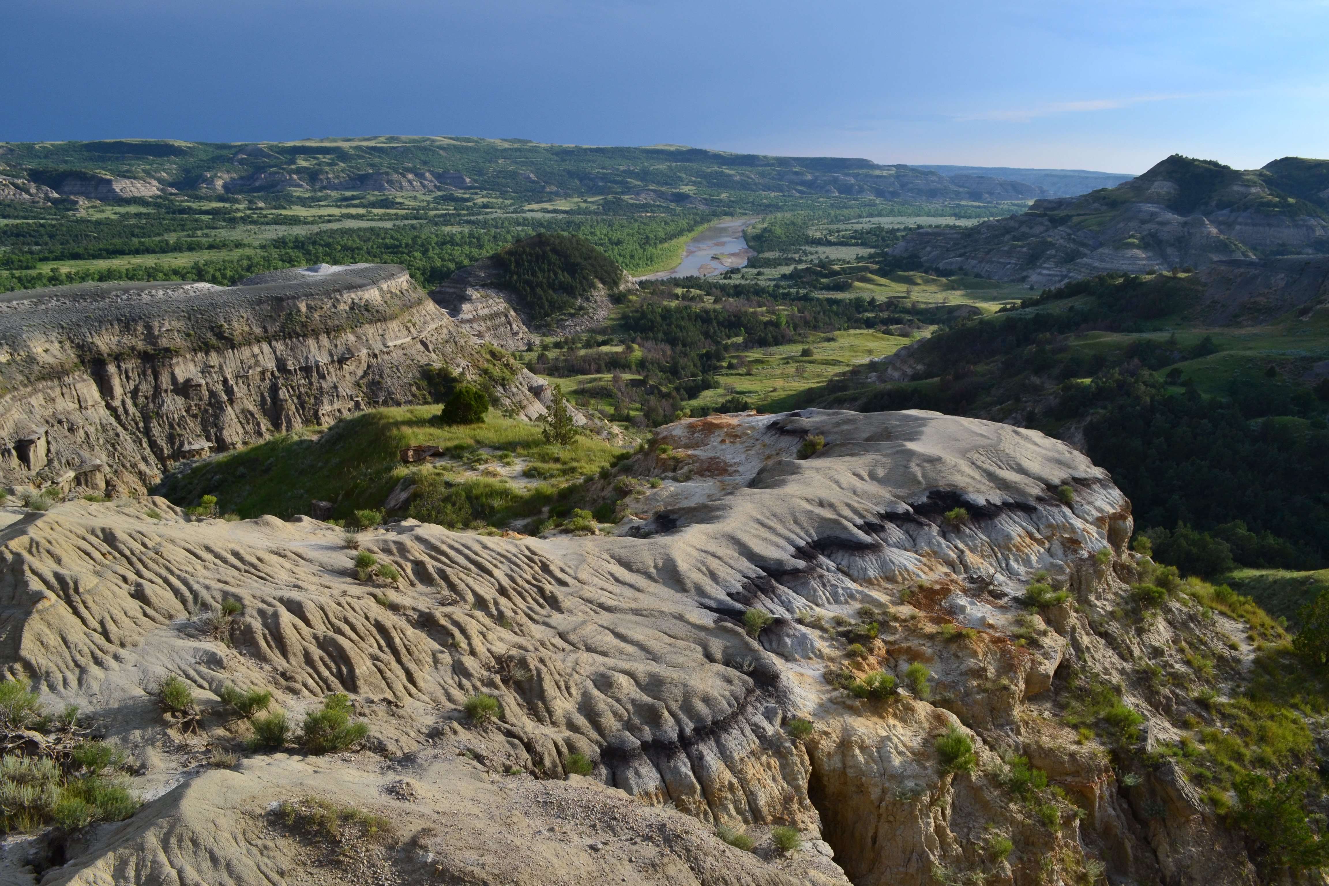
The Moment: From the overlook, the Little Missouri River bends through the badlands in a wide arc. The light at sunset hits the bentonite clay layers in the canyon walls - gray, tan, and rust-red bands that look like they were painted on.
What Most Underestimate: How fast the sun drops behind the canyon wall. If you time this for sunset, the overlook goes dark about 15 minutes before the actual sunset time. Come 20 minutes earlier than you think you need.
Best Time: Late afternoon for the light. The trail stays in shadow by late afternoon, which helps in summer.
Painted Canyon Trail: The Postcard Hike
Distance: 1.1 mile loop
Elevation Gain: 180 feet
Trailhead & Parking: Painted Canyon Visitor Center, off I-94 exit 32. The lot is large, but it also serves the overlook and the visitor center. By 10 AM in summer, you will park at the far end.
The Trail: This trail drops from the visitor center overlook down into the canyon you just viewed from above. The descent is quick - switchbacks cut into the clay slope that feel steeper going down than the elevation gain suggests. The trail levels out on the canyon floor, then loops back up. The surface alternates between packed dirt and exposed bedrock. Keep an eye out for the interpretive signs along the way; they explain the geology of the bentonite clay formations you are walking through.
The Moment: About halfway through the loop, the trail opens into a wide bowl where the canyon walls rise 200 feet on three sides. The colors change throughout the day as the sun angle shifts across the clay layers.
What Most Underestimate: The climb back up. It is not long - maybe a quarter mile - but it is loose and steep, and the sun hits it directly by mid-morning. People who stroll down casually regret it on the return.
Best Time: Early morning, before 9 AM. The light angles into the canyon rather than straight down, and the temperature difference is dramatic.
Coal Vein Trail: Geology You Can Touch
Distance: 0.7 mile loop
Elevation Gain: 50 feet
Trailhead & Parking: Pullout on the Scenic Loop Drive, about 8 miles from the entrance. Small lot, rarely full because most visitors drive past it.
The Trail: This is an interpretive trail through a coal vein that ignited naturally and burned for decades. The surface is flat and easy - packed gravel and boardwalks in sections. The trail passes exposed coal seams, red scoria (baked clay turned brick-hard by the underground fire), and the remnants of early 20th-century mining efforts. Signs explain the 1951 fire that smoldered underground.
The Moment: The scoria formations along the trail are a deep reddish-purple that looks almost artificial. The contrast against the gray-green sagebrush is the most distinct color palette in the park.
What Most Underestimate: How little shade exists. This is a short trail, but on a 95-degree day the reflected heat off the red scoria is noticeable.
Best Time: Any time of day for the short distance, but early morning or late afternoon keeps the heat manageable.
Buckhorn Trail: The Full Backcountry Experience
Distance: 11.3 mile loop
Elevation Gain: 1,200 feet cumulative
Trailhead & Parking: Buckhorn Trailhead on the Scenic Loop Drive, about 7 miles from the entrance. The lot holds 8-10 cars. It fills early June through September.
The Trail: This is the most demanding maintained trail in the park. The route follows old ranch roads and game trails through the South Unit's backcountry, crossing open prairie, dropping into dry creek beds, and climbing ridges that give 360-degree views of the badlands. The surface varies wildly - packed clay, loose gravel, exposed sandstone, and sections of ankle-deep sand. Cell service drops out at about the 2-mile mark and does not return until you are back on the loop drive.
The Moment: At the 5-mile mark, the trail crests a ridge that looks west toward the Elkhorn Ranch Unit. On a clear day you can see the river valley stretching to the horizon. You will not see another person from this point most days.
What Most Underestimate: The total time. The park service estimates 6-8 hours, but 8 is realistic for most hikers. The loose surfaces slow you down more than the elevation suggests. Also, the trail is not always well-marked; cairns and posts guide the way, but they can be hard to spot in low light.
Best Time: Start at sunrise, no later than 7 AM April through October. You want to be past the halfway point before noon.
Petrified Forest Trail: A Hike Through Ancient Wood
Distance: 3.5 miles round trip (out and back) or 10.9 mile loop connecting to other trails
Elevation Gain: 200 feet for the out-and-back; 1,000 feet for the full loop
Trailhead & Parking: End of the Scenic Loop Drive, about 14 miles from the entrance. The lot is small but sees less traffic than the main trailheads.
The Trail: The out-and-back option is straightforward - follow a jeep trail across open prairie to a petrified forest with logs scattered across the landscape. The full loop connects to the Jones Creek Trail and requires navigation skills. The petrified wood dates to the Paleocene epoch, roughly 60 million years old. Keep an eye out for logs that still show tree rings and bark texture. Do not take any - the park treats fossil removal seriously.
The Moment: The concentration of petrified logs in the designated area is dense enough that you can stand in one spot and count a dozen large specimens within 50 feet.
What Most Underestimate: The wind. This section of the park gets constant wind that the canyon trails block. Even on calm days elsewhere in the park, expect 15-20 mph gusts here.
Best Time: Spring (April-May) and fall (September-October) when temperatures stay below 80 and the wind is less intense.
Photo: NPS via NPS.gov (Public Domain)
North Unit Trails
Caprock Coulee Trail: The Essential North Unit Hike
Trailhead & Parking: North Unit Visitor Center, at the end of the park road (14 miles from US 85). The lot is adequate for the North Unit's lower traffic, but fills by 11 AM in July and August.
The Trail: This is the hike that best represents the North Unit's character - narrow coulees (steep-sided valleys) carved into the badlands, with sudden views of the Little Missouri River below. The short loop stays in the coulee and is well-defined. The full loop climbs out of the coulee onto the plateau, then follows the rim back. The trail narrows here significantly in spots, with loose rock underfoot. The full loop section along the rim has exposure - not dangerous for careful hikers, but noticeable.
The Moment: On the full loop, the rim section offers a view straight down to the river, with the North Unit's distinctive banded buttes in the distance. The light in the hour before sunset turns the clay bands gold and the shadows deep purple.
What Most Underestimate: The heat retention in the coulee. The narrow canyon traps heat and reflects it off the walls. By 2 PM in June, the coulee floor runs 10-15 degrees hotter than the rim.
Best Time: Late afternoon for light and temperature. The coulee goes into shadow earlier than the rim, so time accordingly.
Little Mo Nature Trail: Family-Friendly and Informative
Distance: 0.7 mile loop
Elevation Gain: 60 feet
Trailhead & Parking: North Unit Visitor Center. Shared parking with the Caprock Coulee trailhead.
The Trail: A self-guided interpretive loop with numbered stops that cover the badlands ecosystem. The surface is packed gravel with gentle grades. The trail loops along the edge of a small prairie dog town - expect to hear their warning calls as you approach. No significant exposure, no difficult sections.
The Moment: The prairie dogs are active throughout daylight hours, and the trail passes close enough to watch them without binoculars. Bison sometimes wander through the area, which clears the prairie dogs out quickly.
What Most Underestimate: How much the interpretive content adds. The booklet (available at the visitor center or online) covers plant adaptations, erosion patterns, and animal behavior in specific detail. Read it before or during the walk.
Best Time: Morning, when prairie dog activity peaks and the trail is cooler.
Achenbach Trail: North Unit's Buckhorn Equivalent
Distance: 6.8 miles one way, or various loop configurations up to 14 miles
Elevation Gain: 700 feet (one way); loops vary
Trailhead & Parking: End of the park road near the North Unit Campground. Limited parking at the trailhead; overflow available at the campground.
The Trail: This trail runs the length of the North Unit, following the Little Missouri River for sections before climbing onto the plateau. The terrain is more varied than the South Unit's trails - river bottom, cottonwood groves, open prairie, and badlands rim. The trail is less maintained than the South Unit trails; expect overgrown sections in late summer and occasional washouts after heavy rain. The Maah Daah Hey Trail connects at the northern boundary.
The Moment: The section where the trail climbs from the river bottom to the rim gains 400 feet in half a mile. From the top, the river appears as a green ribbon through the tan badlands, and you can see the entire North Unit laid out below.
What Most Underestimate: Navigation difficulty. The trail junctions are not all clearly marked, and the river-bottom sections can be confusing after high water re-routes the path. Download a map before you go - cell service drops out at the trailhead.
Best Time: May or September. July and August river-bottom temps exceed 100 degrees, and the exposed rim section offers no shade.
Photo: NPS via NPS.gov (Public Domain)
Seasonal Trail Conditions
April-May: Snow melt and spring rain make clay trails slick. The bentonite clay in the badlands becomes extremely slippery when wet - if it has rained in the past 24 hours, reconsider any trail with significant clay sections. Trails typically dry within 48 hours of rain. Wildflowers peak in late May. Prairie dogs are active. Bison calving season runs April through June - give cows and calves at least 100 yards.
June-August: Daily highs from 85 to 105 degrees. Zero shade on most trails. Afternoon thunderstorms develop regularly, producing lightning that is dangerous on exposed rim sections. Be off high ground by 2 PM. Prairie dog towns are fully active. Tick density increases in grassy sections - check yourself after any trail that goes through tall grass.
September-October: The best hiking window. Highs range from 60 to 80 degrees. Reduced insects. Fewer visitors after Labor Day. Fall color in the cottonwood groves along the river bottoms peaks in early October. Trail conditions are generally dry and stable.
November-March: Daytime highs from 20 to 40 degrees. Snow accumulations vary. Trails are often icy in the morning. The North Unit road closes when snow accumulates. Wind chills regularly drop below zero. Not recommended for casual hikers. If you go, carry microspikes and winter gear.
Photo: NPS via NPS.gov (Public Domain)
Trailhead Logistics
The South Unit's Scenic Loop Drive is 14 miles of paved road that accesses most trailheads. In peak season (June-August), the loop can take 45 minutes to drive due to bison jams - traffic stops for animals crossing. Plan your trail access accordingly.
The North Unit is quieter. The park road is 14 miles from the entrance to the visitor center. Fewer trailheads, less traffic, and a different feel. If the South Unit lots are full by 9 AM - which they regularly are in July - the North Unit is a 45-minute drive north and has available parking well into the morning.
No shuttle system exists in either unit. Every trailhead requires a personal vehicle.
Water is available at the South Unit Visitor Center, Painted Canyon Visitor Center, and North Unit Visitor Center. No water sources on any trail in either unit. The Little Missouri River is not safe to drink from untreated due to silt and agricultural runoff upstream.
Fires are not permitted in the backcountry. Stoves are allowed with a permit for overnight trips.
What to Carry
The specific conditions at Theodore Roosevelt National Park demand gear choices that differ from hiking in mountain parks.
Footwear: Trail runners or light hikers with good tread will work for trails up to 5 miles. For the Buckhorn or Achenbach trails, use boots with ankle support. The loose gravel and sand on sloped surfaces will test your ankles. Western rattlesnakes are present - not common, but present - and boots provide a margin of protection. Closed-toe shoes are non-negotiable on every trail.
Water: The park service recommends one gallon per person per day in summer. For the Buckhorn Trail, that means carrying at least 3 liters minimum, with a plan to filter or cache if extending the route. No trail has water access. No exceptions.
Sun Protection: A wide-brim hat, long sleeves, and sunscreen rated SPF 50 or higher. The reflected UV off the bentonite clay amplifies exposure. Sunburn on the underside of your chin is a common complaint from hikers who only wore a baseball cap.
Navigation: Download offline maps before arrival. Cell service is limited to the visitor center areas and the first mile of the Scenic Loop Drive. The Buckhorn and Achenbach trails lose signal within 10 minutes of starting. A physical map from the visitor center costs $1 and is worth carrying.
Emergencies: First-aid kit with blister treatment - the loose gravel works its way into shoes and creates hot spots within 3 miles. An emergency blanket or bivvy. A whistle. SAR response time in the backcountry runs 2-4 hours.
Practical Takeaways
The 3-liter rule applies to every trail over 2 miles in summer. If you carry less, you will turn back early.
Start every South Unit trail before 8 AM June through August. The heat becomes genuinely unsafe by noon, and afternoon lightning risk is real.
The Painted Canyon Trail is harder than the brochure suggests. The 180 feet of elevation gain is concentrated in steep, loose switchbacks on the return.
Bison have the right of way on every trail. The park service recommends 100 feet of distance minimum. That distance increases to 200 feet if a calf is present. If a bison is standing on the trail, you wait.
The North Unit's trails offer a quieter experience but require more driving. The trade-off is worth it if the South Unit lots are full.
Mosquitoes are negligible on the dry trails but dense in the river bottoms and campground areas from June through August. Carry repellent if you plan to sit still near water.
The best view in the park is from the Wind Canyon Trail overlook 20 minutes before sunset. Arrive 40 minutes early to get parking and watch the light change.
Trail conditions change fast after rain. The bentonite clay turns into a surface that will add 2 inches to your shoe height and make every step a slip hazard. Wait 24 hours after rain before attempting any trail with significant clay sections.
The Maah Daah Hey Trail passes through the park on its 144-mile route. Sections within the park boundaries do not require permits, but overnight trips outside the park do.
Check the park's trail conditions page on the morning before you hike. Washouts, bison activity, and trail closures are posted there, and ignoring them is the most common way a good hike turns into a problem.