The Jedediah Smith Redwoods Day Use Area serves as the northern gateway to the world's tallest trees. Arrive before 10 AM to secure a parking spot without the wait.
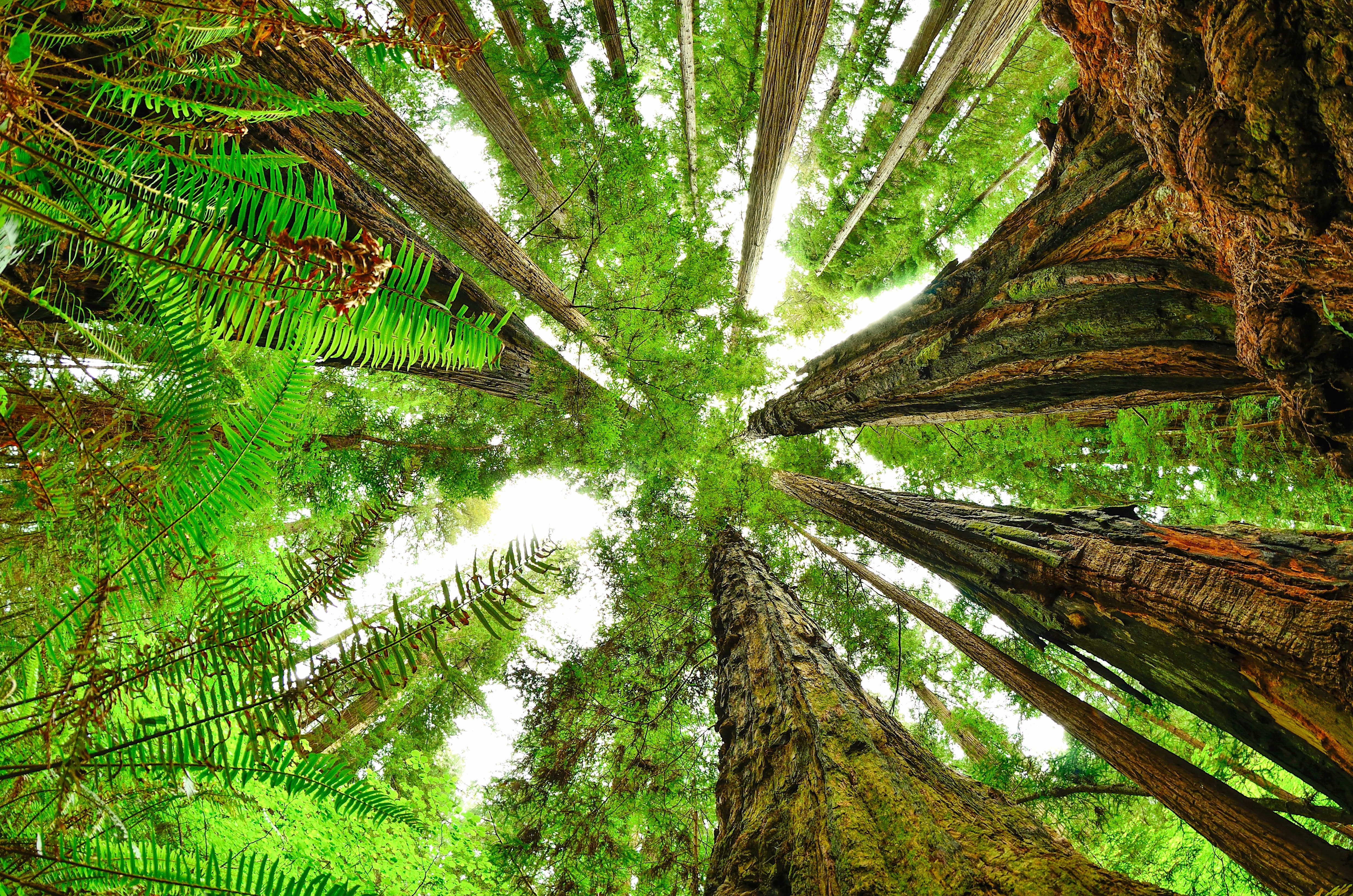
NPS via NPS.gov (Public Domain)
Jedediah Smith Redwoods Day Use Area
9 min read
Places & Points of Interest
The Jedediah Smith Redwoods Day Use Area serves as the northern gateway to the world's tallest trees. Several tables are scattered under the redwoods near the river.
Your plans
Overview
The Jedediah Smith Redwoods Day Use Area serves as the primary access point for the northern section of Redwood National and State Parks. It's where the wild and scenic Smith River meets a cathedral of old-growth coast redwoods, some standing over 300 feet tall. This isn't just a scenic pull-off; it's a functional hub. From here, you can launch a kayak, find a picnic table under a canopy so dense it dims the midday sun, or step directly onto trails that lead into the heart of the groves. The air carries the damp, mineral scent of river water and decaying redwood bark - a smell that defines this stretch of Northern California. Rangers often point visitors here first, as it provides the most concentrated access to the iconic forests near Crescent City without requiring a long drive on unpaved roads.
Quick Information
* Entrance Fee: There is no entrance fee for Redwood National Park. Jedediah Smith Redwoods State Park, which this day use area is part of, charges a day use fee. As of 2026, that fee is $8.00 per vehicle. An annual California State Parks pass is a cost-effective alternative for multiple visits.
* Hours: The day use area is open from sunrise to sunset. The parks themselves are open 24 hours a day, year-round.
* Best Time to Visit: Late May through September offers the driest hiking conditions, though expect coastal fog. For solitude and vibrant green undergrowth, visit in late April or October.
* Location: Northern California, near Crescent City. The physical address for the park headquarters is 1111 Second Street, Crescent City, CA 95531.
* Accessibility: The main picnic area has paved pathways and accessible restrooms. Most trails leading from this area, however, are natural surface with roots and uneven terrain, and are not considered wheelchair-friendly.
* Cell Service: Spotty to non-existent once you're among the redwoods. Assume you will have no signal on trails.
* Restrooms: Flush toilets and running water are available at the main day use area parking lot.
* Parking: The main lot can accommodate about 40 vehicles. It fills completely by late morning on summer weekends and holidays. Overflow parking is extremely limited. Your best bet is to arrive early or visit on a weekday.

Getting There
The Jedediah Smith Redwoods Day Use Area is located just off U.S. Highway 199, about 9 miles east of Crescent City. From Crescent City, head east on Highway 199. The signed turnoff for the day use area will be on your left. If you're coming from Oregon on I-5, take the Grants Pass exit and follow Highway 199 south for approximately 60 miles; the park will be on your right shortly after you pass through the small community of Hiouchi.
From San Francisco, it's a solid six to seven-hour drive north via US-101. From Portland, it's about a six-hour drive south. The park is roughly a four-hour drive west from Redding. GPS units can be unreliable in this region; setting your destination to "Jedediah Smith Redwoods State Park" generally works, but having a paper map or downloaded offline maps is a wise backup. The parking situation here is straightforward but limited - once the main lot is full, options are few.
What to Expect
You'll notice the damp, quiet air first, with light filtering through the canopy in soft, green-tinted shafts. Temperatures typically run 10 to 15 degrees cooler than nearby Crescent City. Underfoot, a carpet of redwood duff—decaying bark and needles—muffles sound. Listen for the constant rush of the Smith River, ravens' croaks, and the occasional creak of a massive tree moving in the wind overhead. Most first-time visitors underestimate the sheer scale of these groves.ate. Your neck will ache from looking up. The trail surfaces are a mix of packed dirt, exposed roots that look like petrified snakes, and occasional muddy patches that persist even in summer. This isn't a manicured garden; it's a functional forest where you walk among living giants. The humidity keeps everything lush, from the five-foot-tall sword ferns to the moss that cloaks every fallen log.

Top Attractions & Points of Interest
Stout Memorial Grove
Considered by many to be the heart of Jedediah Smith Redwoods State Park, this grove contains some of the most massive and visually striking trees in the northern unit. The grove is flat and easy to walk, but getting there requires a short drive or bike ride down Howland Hill Road, a narrow, unpaved scenic drive. It's worth the extra effort. The trees here cluster close together, their colossal trunks creating a sense of being in an organic, sky-scraping temple.
Howland Hill Road
This ten-mile dirt and gravel road cuts right through old-growth redwood stands. It's not for oversized RVs or those afraid of dust, but for passenger cars, it's an unforgettable experience. The redwoods grow so close to the road that their branches sometimes brush your vehicle. It provides access not only to Stout Grove but also to the trailhead for the Boy Scout Tree Trail. Drive it slowly. Early morning or late afternoon light creates long, dramatic shadows across the road.
Simpson-Reed Trail
If you're passing through on Highway 199 and want a quick, immersive redwood experience without a long hike, this is your stop. It's a gentle, 0.8-mile loop on a well-maintained trail through a old-growth forest. The parking lot is small, holding maybe 8 cars, so timing matters. It's a perfect introduction to the ecosystem, with interpretive signs explaining what you're seeing.
Smith River Access
The day use area provides the easiest public access to the Smith River within the park. In summer, the river's pools are popular for swimming (the water is cold, always). It's also a launch point for kayakers and canoeists. Anglers fish for steelhead and salmon here in season. The sound of the river is a constant, calming backdrop to any picnic.
Boy Scout Tree Trail
For a more substantial hike, this trail begins from a pull-out along Howland Hill Road. It's a 5.5-mile round trip deep, quiet forest to a modest but pretty waterfall. The trail narrows here, winding through ferns and downed logs. Rangers will tell you it's moderately strenuous, with some steady elevation change on the return trip. You'll likely have long stretches to yourself.
Activities
Hiking is the primary draw. From the day use area, you can connect to a network of trails ranging from easy riverside strolls to the more committed Boy Scout Tree Trail. The Stout Grove loop is a non-negotiable for first-time visitors.
Water activities center on the Smith River. Swimming is possible in slower pools during summer, but the water is fed by snowmelt and remains brisk. Kayaking and canoeing are excellent here, with the day use area serving as a convenient put-in. Always check river conditions, as levels can change rapidly.
Picnicking is why this spot is called a day use area. Several tables are scattered under the redwoods near the river. They are first-come, first-served and are often occupied by midday. Pack extra layers - the shade is deep and cool.
Scenic Driving on Howland Hill Road is an activity in itself. It's a slow, winding journey best enjoyed with frequent stops to get out and look up. Don't rush it. The road is narrow; use pullouts to let oncoming traffic pass.
Wildlife viewing is mostly passive here. You might see black-tailed deer, varied thrushes, or pileated woodpeckers. Roosevelt elk tend to graze in more open prairies further south, but they occasionally wander near the river. For dedicated wildlife viewing, you'll want to explore other areas of the parks.

Seasonal Guide
Summer (June-August): The most popular and driest season. Daytime highs near the river can reach the low 70s, but are often cooler. Coastal fog is common, sometimes burning off by afternoon. This is when parking is most competitive. Arrive early.
Fall (September-October): Arguably the best time for hiking. Crowds diminish, temperatures are still mild, and the first rains revive the mosses and ferns, making the forest intensely green. Rain gear becomes essential.
Winter (November-March): The wet season. Expect rain, and lots of it - the region averages 60-80 inches. Trails are muddy, the river runs high and brown, and the forest is at its most dramatic and moody. You'll have it mostly to yourself. Check for road closures after heavy storms.
Spring (April-May): A season of transition. Rain tapers off, wildflowers like trillium and redwood sorrel bloom on the forest floor, and the summer crowds haven't yet arrived. Weather is unpredictable - sun one hour, a downpour the next.
Practical Information
The day use fee for Jedediah Smith Redwoods State Park is $8 per vehicle as of 2026. This is separate from any national park fee (which doesn't exist here). You can pay at the self-service station in the day use parking lot. An annual California State Parks Pass ($195 as of 2026) covers this and all other state park day use fees.
For camping options, the adjacent Jedediah Smith Campground is one of the most sought-after in the system, with sites among the old-growth. Reservations are essential and open six months in advance. More details on all park campgrounds can be found in our guide to camping options.
Nearby lodging and accommodations are concentrated in Crescent City, which offers a range of motels, hotels, and vacation rentals. For a wider selection of services, consider the guide to lodging and accommodations.
There are no restaurants or gas stations within the day use area. The last chance for fuel and supplies is in Crescent City (to the west) or Hiouchi (a small community with a store just east of the park).

Safety & Preparation
Your main safety concerns here are environmental. Hypothermia is a real risk even in summer due to the damp, cool conditions. Dress in synthetic or wool layers - cotton loses its insulating ability when wet. Footing on trails is uneven and often slippery. Wear sturdy hiking shoes with good traction. The Smith River is powerful and cold; never turn your back on it, and supervise children closely.
There are no poisonous snakes of significant concern in these redwood forests. Black bears are present but rarely seen and generally avoid people. Properly store all food and trash.
Cell service drops out at the day use area parking lot. Do not rely on your phone for navigation or emergency communication on trails. Let someone know your plans. In an emergency, the nearest ranger station is the Hiouchi Information Center, located just east on Highway 199.
Insider Tips
- The Parking Workaround: If the main day use lot is full, don't circle. Drive east on Highway 199 for one minute to the Hiouchi Information Center. Park there (if space allows), use their restrooms, get trail advice from the rangers, and then walk the 0.3-mile connector trail that leads directly from behind the center into the day use area and trail system.
- Quiet Hour: The forest feels most profound in the hour after sunrise. The light is low and horizontal, the wildlife is active, and you'll likely have the groves to yourself. It's a different experience than midday.
- Footwear is Non-Negotiable: The official website doesn't emphasize how muddy and root-crossed trails can be, even in August. Trail runners or hiking boots are a must. Sandals or street shoes will leave you frustrated and unstable.
- Skip the Main Picnic Area at Peak Times: Instead of jostling for a table at the main cluster, bring a blanket or camp chairs. Walk down any of the trails for five minutes and you'll find a quiet, dry spot on the forest floor or a sunny rock by the river for a more peaceful meal.
- Howland Hill Road Logistics: If you plan to drive Howland Hill Road to access Stout Grove or other trails, do it before you park at the main day use area. The road is one-way for the most scenic section (westbound from the Grove), ending near the day use area. This creates an efficient loop.
- The Gift Shop Secret: The Hiouchi Information Center has a small but excellent bookstore with field guides and natural history books. It's a better resource for learning about the redwoods than the typical souvenir shops in town.
- Check the Trail Register: At the head of major trails like Boy Scout Tree, there's often a sign-in notebook. Glance at the most recent entries. They frequently contain useful, real-time notes from other hikers about trail conditions, wildlife sightings, or weather up ahead.
For more information, see our complete National and State Parks Guide.
Sources
- Official source: NPS — Redwood National Park nps.gov/redw/index.htm
Photo Gallery
More to Explore

Park Guide
Acadia National Park: Carriage Roads, Cadillac Mountain & 2026 Guide
Discover carriage roads, Cadillac Mountain, and rugged Maine coast. Complete 2026 guide to Acadia National Park — trails, fees, lodging, permits, and what rangers recommend.

Hiking Guide
Grand Canyon Hiking Trails: Day Hikes, Water Sources & Rim to Rim
Compare Grand Canyon hiking trails: Bright Angel, South Kaibab, Hermit, Grandview, and rim to rim, with distances, elevation, water stops, and trailhead access for each.

Best Of
Best of Glacier Bay National Park
The best of Glacier Bay is reached by boat: ranger-led day tours up the bay to the tidewater glaciers. What's worth it, how to book, and when to go (2026).

Campsite Guide
White Sands Backcountry Camping: Closed for 2026 — What to Know
As of 2026, backcountry camping at White Sands National Park is closed for site rehabilitation. What that means, and where to camp nearby instead.

Weather Guide
Guadalupe Mountains National Park Weather: Weather
Guadalupe Mountains National Park: weather guide guide updated 2026. Practical visitor information, reservations, and seasonal tips worth bookmarking before

Best Of
Best of Cuyahoga Valley National Park: Best Things to Do
Seeing a Cleveland Orchestra concert with the woods as your backdrop is a uniquely Cuyahoga Valley experience.
Sign in to join the conversation.
Sources & Attribution
Location data courtesy of the National Park Service (U.S. Department of the Interior). NPS data is public domain. Official NPS page.
Images: NPS; NPS; NPS; NPS; NPS.
Map data © OpenStreetMap contributors.
Park operations alerts: NPS.gov · Weather and weather hazards: National Weather Service · Live conditions.
Information may change. Always verify fees, hours, and conditions directly with the official source before visiting.
Did this guide help? Share it with a friend.