Great Sand Dunes National Park Hiking: Hiking In (2026 Guide)
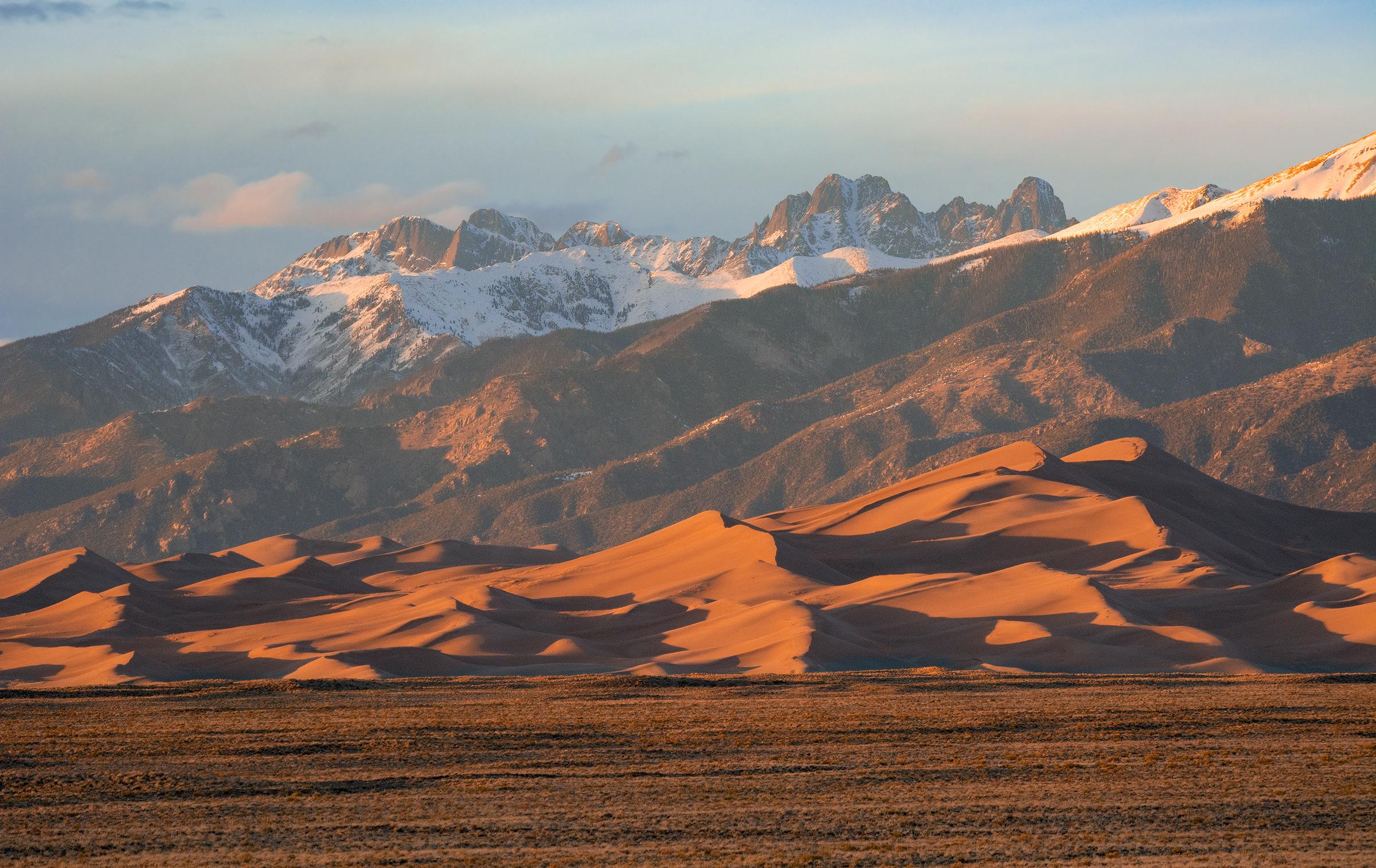
NPS via NPS.gov (Public Domain)
Hiking in Great Sand Dunes National Park
9 min read
Hiking Guide
Complete 2026 hiking guide for Great Sand Dunes National Park. Trails, difficulty ratings, seasonal conditions, and practical tips for every skill level.
This article contains affiliate links — we may earn a small commission at no extra cost to you.
The silence hits you first. Your own footsteps on coarse sand are the only sound, and even that gets lost in the scale of the place. Then you feel it in your legs. Hiking here isn't measured in miles—it's counted in vertical feet earned on ground that slides away with each step. You're climbing a mountain of sand.
What Hiking Here Actually Means
Leave the trail markers behind. Here, you navigate a 30-square-mile dunefield that the wind rewrites daily. While maintained trails exist in the surrounding foothills, the real experience is traveling cross-country on sand. This requires adjusting your expectations—measure progress by exertion, not mileage. One mile on these dunes often equals three on a firm trail.
Most first-time visitors underestimate two things. First, the altitude - the dunefield base sits at 8,200 feet. Second, the sand temperature. Mid-day summer surface temps can hit 160°F. Rangers will tell you that a "hike" here is best done in the very early morning or late evening from May through September. Your fitness level matters less than your preparation for sun, heat, and relentless, yielding terrain. This is a park where your water carry is your most critical piece of gear. For a broader context on the park, our complete visitor guide covers the essentials.
The High Dune Loop: The Benchmark Climb
This isn't a signed trail. It's the most direct route visitors take to summit the first major dune ridge visible from the parking lot, offering the first real panorama of the entire dunefield. It's the park's de facto fitness test.
Distance: 2.5 miles round trip
Elevation Gain: 650 feet
Trailhead & Parking: Start from the main Dunes Parking Lot. This lot fills by 10 AM on summer weekends and holidays. Overflow parking is along the entry road, adding a half-mile walk on pavement. There's no shade.
The Trail: You cross the seasonal Medano Creek bed first - which can be a damp walk or a wide, dry wash depending on the month. Then you hit the sand. The slope increases steadily. You'll take two steps up, slide one step back. The sand's consistency changes daily; sometimes it's firm, sometimes it's soft and draining. There are no switchbacks. You pick your line straight up the dune face.
The Moment: Turning around at the top of the first major ridge. The parking lot becomes a tiny grid below, and the entire dunefield unfolds westward in waves of shadow and light, backed by the jagged line of the Sangre de Cristo Mountains.
What Most Underestimate: The descent. It looks easy, but the steep, unstable sand can be hard on knees and ankles. Some people run down; others sit and slide. Both work.
Best Time: Start at sunrise. You'll have the coolest sand, the longest shadows for photography, and a reasonable chance of having the ridge to yourself. Avoid mid-day entirely in summer.

Star Dune via High Dune: The Full Dunefield Trek
For those who find High Dune merely a warm-up. Star Dune is the tallest dune in North America at 750 feet from base to summit. This is a serious, committing sand hike.
Distance: 6-7 miles round trip
Elevation Gain: 750 feet (net), but expect over 1,200 feet of total climbing with the dune valleys you cross.
Trailhead & Parking: Same Dunes Parking Lot. If you're attempting this, you must be in the lot by 7 AM at the latest to allow enough time before the heat sets in.
The Trail: Follow the common path to High Dune, then continue west across a vast "sand sea." The route is entirely unmarked. You're navigating by landmark - aiming for the tallest dune mass on the horizon. You'll descend into deep, soft valleys and climb steep, knife-edge ridges. The sand is often softer and deeper the farther you go.
The Moment: Standing on the narrow crest of Star Dune. The view is a 360-degree ocean of sand. You can see the entire dunefield boundary and the curve of the mountains wrapping around it. The silence is absolute.
What Most Underestimate: The navigation and the exposure. There is no shade, no water, and no cell service. If you lose your bearing, you can end up adding miles. Most experienced visitors carry a GPS or download an offline map with the dune's coordinates.
Best Time: Early morning in late spring (May) or early fall (September). Summer attempts require a pre-dawn start and extreme heat preparedness.
Mosca Pass Trail: A Forest Reset
After the dunes, the shade of a pine forest feels like a different continent. This trail climbs from the dunefield edge into the Sangre de Cristo foothills, following Mosca Creek.
Distance: 6.8 miles round trip
Elevation Gain: 1,450 feet
Trailhead & Parking: The trailhead is at the west end of the Dunes Parking Lot, near the picnic area. It shares the same crowded lot, but hikers on this trail are fewer.
The Trail: A well-defined dirt and rock path that climbs steadily alongside the creek. You'll move from pinon-juniper woodland into ponderosa pine and aspen. The trail narrows here, with some rocky, uneven sections. Several stream crossings require hopping on rocks - they can be slippery.
The Moment: Reaching the pass itself, marked by a historic homesteader's cabin foundation. You get a framed view back east over the entire dunefield from above, a perspective few visitors see.
What Most Underestimate: The elevation gain is consistent and can be taxing after a day on the dunes. It's also a popular trail for horseback riders - step aside and give them the right of way.
Best Time: Mid-morning to afternoon. The forest canopy provides shade, making it a good summer option when the dunes are too hot. Fall offers brilliant yellow aspen colors.

Montville Nature Trail: The Short & Strategic Overlook
This is the trail for when you're short on time, energy, or have small children. It delivers a top-tier view for minimal effort.
Distance: 0.5 miles loop
Elevation Gain: Minimal
Trailhead & Parking: The trailhead is 1.5 miles past the visitor center on the main park road. There's a small, paved lot that rarely fills completely.
The Trail: A compact, crushed gravel loop through a shady forest of ponderosa pines. It's smooth, wide, and accessible. Interpretive signs point out natural and historical features.
The Moment: The overlook about halfway through. A short spur leads to a rocky platform with a sudden, open view of the entire dunefield and Medano Creek below. It's the best photo op for the dunes' scale without hiking a step on sand.
What Most Underestimate: Its value as a scouting trip. From here, you can assess the creek flow, see where people are hiking on the dunes, and judge the light before committing to your own dune hike.
Best Time: Any time of day. It's a good sunset spot, as the late light turns the dunes a deep orange.
Medano Pass Primitive Road & Lake Trail: 4WD Access Required
This is backcountry hiking, contingent on having a high-clearance 4WD vehicle to navigate the deep sand and creek crossings of Medano Pass Road. It accesses the alpine terrain of the National Preserve.
Distance to Medano Lake: 4.2 miles round trip from the 4WD trailhead
Elevation Gain: 1,100 feet
Trailhead & Parking: Drive the 11-mile Medano Pass Primitive Road to the Medano Lake Trailhead. This road is for 4WD vehicles only, with soft sand and nine creek crossings. Parking at the trailhead is limited to a small pull-off.
The Trail: A steady climb through spruce-fir forest to a small, clear alpine lake at 11,600 feet. The trail is rocky and root-strewn in places. You're likely to have it to yourself.
The Moment: The first glimpse of the lake, with the dramatic cirque of Mount Herard rising behind it. The air is cool and smells of pine and damp earth - a stark contrast to the dunefield.
What Most Underestimate: The difficulty of the road. Check current conditions at the visitor center. The creek crossings can be impassably deep in late spring. This road is closed to through traffic in winter.
Best Time: July through September, when the road is driest and the high country is snow-free.

Seasonal Trail Conditions
Your hiking experience is dictated by the month. Rangers emphasize this.
April-June: This is peak flow for Medano Creek, often making a "beach" area in front of the dunes. Creek crossings on Mosca Pass Trail can be high. The dunes are cool and firm in the mornings. Afternoon winds are common.
July-August: The creek typically dries up by mid-July. Dune surface temperatures are dangerous from 10 AM to 4 PM. Hiking must be done at dawn or dusk. Afternoon thunderstorms are frequent in the mountains; be off Mosca Pass Trail by early afternoon.
September-October: The prime season for hiking. Cool nights, warm days, minimal creek flow, and stable weather. The sand is comfortable to walk on throughout the day. Mosca Pass Trail is at its best with fall colors in late September.
November-March: Snow dusts the dunes and coats the mountain trails. The dunes are firm and cold, excellent for hiking with microspikes if there's ice. Mosca Pass Trail may be snow-packed; snowshoes are sometimes needed. The Medano Pass Road is closed. For detailed climate patterns, check our guide on the best time to visit.
Trailhead Logistics
Parking strategy is your first challenge. The Dunes Parking Lot is the only paved access for the dunefield, Mosca Pass, and Montville trails. It's full by mid-morning on any decent weather day from May to October. Arrive by 8 AM, or plan to park along the entry road and walk.
There are no park shuttles. You drive yourself everywhere.
Cell service drops out at the park boundary. Do not rely on your phone for navigation on the dunes. The visitor center has free Wi-Fi and paper maps.
There are no water sources on any trail. The only potable water is at the visitor center, the Dunes Parking Lot restrooms, and the camping options at Piñon Flats.
No bear canisters are required for day hiking. For overnight backpacking in the dunefield or preserve (which requires a free permit), secure all food and scented items.
Check trail conditions at the visitor center front desk. Rangers post updates on sand firmness, creek levels, and mountain trail status.

What to Carry
This isn't a generic list. This is what you need for this specific terrain.
Footwear: Low-top hiking shoes or trail runners are better than boots. Sand will get in regardless. Gaiters are highly recommended to keep sand out of your shoes. Leave the hiking boots for Mosca Pass Trail.
Water Carry: One gallon (4 liters) per person for a half-day on the dunes. Two gallons for a full-day attempt like Star Dune. Use insulated bottles or a hydration bladder; water in a standard bottle gets hot fast.
Trekking Poles: Critical for dune hiking. They provide stability and reduce leg fatigue by about 30%. Sand baskets are a must.
Sun Protection: A wide-brimmed hat, UV-blocking sunglasses, and mineral-based sunscreen for your face. The sand reflects intense UV rays from below as well.
Navigation: A dedicated GPS unit or a phone with the offline maps pre-downloaded (using Gaia GPS or similar). A simple compass is useless on the featureless dunes.
The Extras: A lightweight sit pad for breaks (the sand is hot). A small brush to clean sand off gear before getting in your car. Lip balm with SPF.
Practical Takeaways
- Sand temperature, not air temperature, dictates your schedule. If the sand is too hot for your bare hand, it's too hot for your dog's paws.
- Mileage is meaningless. A 2-mile dune hike can take as long as a 6-mile forest hike. Plan by time, not distance.
- The wind usually picks up in the afternoon. Sand blowing at 20 mph is unpleasant; it can become hazardous at higher speeds.
- Rent sandboards or sleds in towns like Alamosa or Blanca before you arrive. The park does not rent them.
- Your car key is a sand magnet. Keep it in a sealed zip-top bag in your pocket.
- After your hike, brush off as much sand as possible at your car. The parking lot has no foot-wash stations.
- The best light for photography is the hour after sunrise and the hour before sunset. Mid-day light flattens the dunes' features.
- If you feel nauseous or get a headache, it's likely altitude sickness. Descend, drink water, and rest.
- Pack extra water in your car for the drive out. You'll be dehydrated, and services are 30 minutes away.
- Check the park's website for the Medano Creek flow forecast if you're visiting in spring. A high flow year means a wider, shallower creek for splashing.
Recommended Gear
What experienced visitors bring to Hiking in Great Sand Dunes National Park
Links may earn us a commission at no extra cost to you. We only recommend gear we believe in.
Hiking Essentials
Hydration Pack (3L)
Hands-free water for long trail days
Trekking Poles (Pair)
Save your knees on steep descents
Hiking Boots (Ankle Support)
Sturdy footwear for rocky, uneven trails
Sun & Heat Protection
Wide-Brim Sun Hat
Full coverage UPF 50+ protection at altitude
Insulated Water Bottle (32oz)
Keeps water cold in desert heat all day
Electrolyte Mix Packets
Replace what water alone cannot during intense heat
Winter Gear
Microspikes / Traction Devices
Essential for icy rim trails in winter months
Packable Down Jacket
Lightweight warmth that stuffs into a pocket
Sources
- Official source: NPS — Great Sand Dunes National Park nps.gov/grsa/index.htm
Photo Gallery
More to Explore

Park Guide
Acadia National Park: Carriage Roads, Cadillac Mountain & 2026 Guide
Discover carriage roads, Cadillac Mountain, and rugged Maine coast. Complete 2026 guide to Acadia National Park — trails, fees, lodging, permits, and what rangers recommend.

Hiking Guide
Grand Canyon Hiking Trails: Day Hikes, Water Sources & Rim to Rim
Compare Grand Canyon hiking trails: Bright Angel, South Kaibab, Hermit, Grandview, and rim to rim, with distances, elevation, water stops, and trailhead access for each.

Best Of
Best of Glacier Bay National Park
The best of Glacier Bay is reached by boat: ranger-led day tours up the bay to the tidewater glaciers. What's worth it, how to book, and when to go (2026).

Campsite Guide
White Sands Backcountry Camping: Closed for 2026 — What to Know
As of 2026, backcountry camping at White Sands National Park is closed for site rehabilitation. What that means, and where to camp nearby instead.

Weather Guide
Guadalupe Mountains National Park Weather: Weather
Guadalupe Mountains National Park: weather guide guide updated 2026. Practical visitor information, reservations, and seasonal tips worth bookmarking before

Best Of
Best of Cuyahoga Valley National Park: Best Things to Do
Seeing a Cleveland Orchestra concert with the woods as your backdrop is a uniquely Cuyahoga Valley experience.
Sign in to join the conversation.
Sources & Attribution
Location data courtesy of the National Park Service (U.S. Department of the Interior). NPS data is public domain. Official NPS page.
Images: NPS; NPS; NPS; NPS; NPS.
Map data © OpenStreetMap contributors.
Park operations alerts: NPS.gov · Weather and weather hazards: National Weather Service · Live conditions.
Information may change. Always verify fees, hours, and conditions directly with the official source before visiting.
Did this guide help? Share it with a friend.