Best of Grand Teton National Park: Best Scenic Drives In (2026)
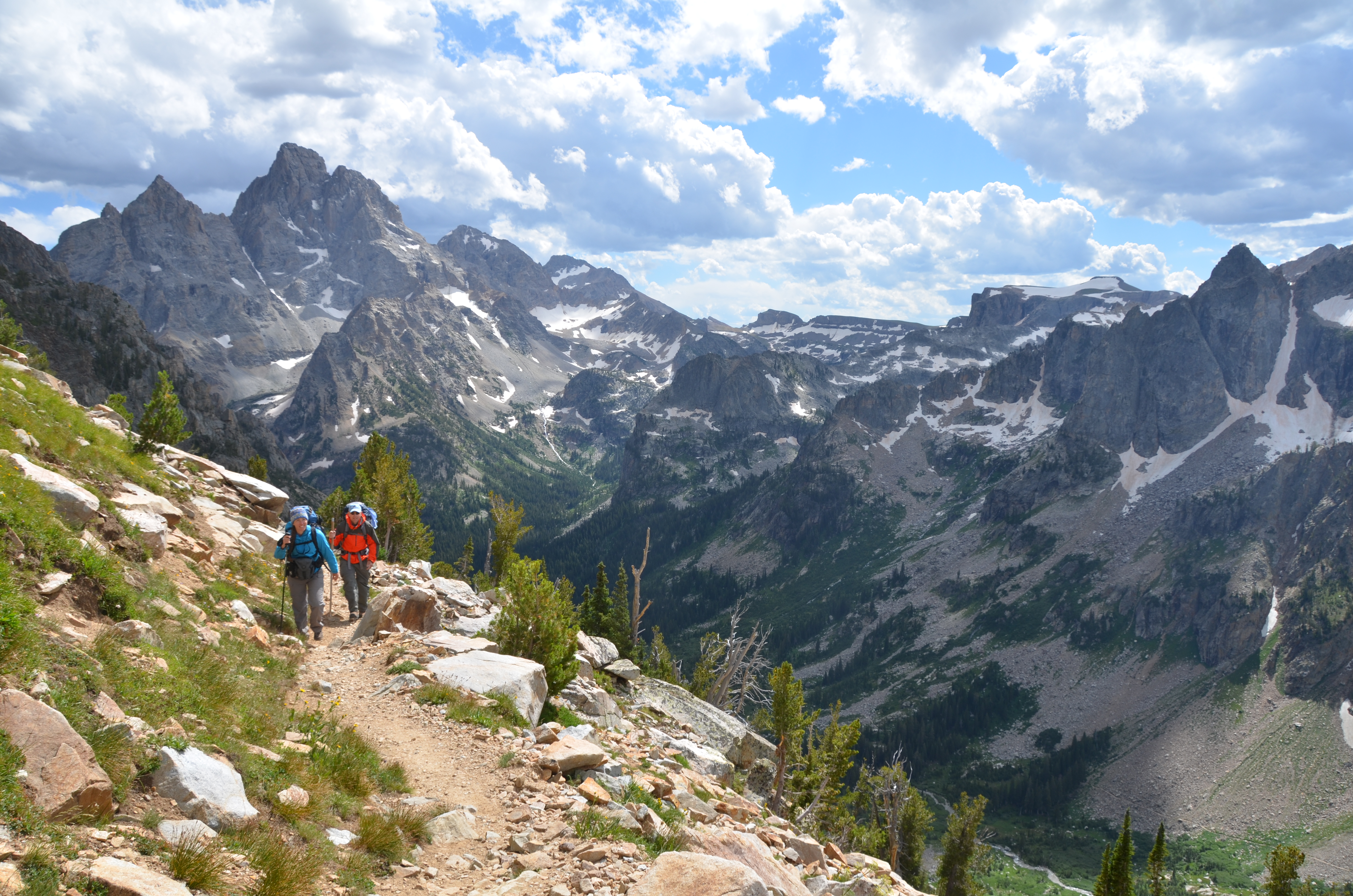
NPS via NPS.gov (Public Domain)
Best of Grand Teton: Jenny Lake, Snake River & Wildlife Drives (2026)
9 min read
Best Of
Plan a one-day Grand Teton visit: start at Moose Entrance by 7:30 AM, hike Taggart Lake, and catch alpenglow at Schwabacher Landing.
This article contains affiliate links — we may earn a small commission at no extra cost to you.
Grand Teton National Park was established in 1929, a latecomer compared to its northern neighbor, but the Teton Range has been shaping the valley for far longer. The best scenic drives here are less about covering miles and more about strategic stops. The mountains don't move, but the light on them changes everything. Your timing matters more than your route.
For more, see hiking trails and camping options.
If You Only Have One Day
Arrive at the Moose Entrance Station by 7:30 AM. The $35 per vehicle fee (as of 2026) buys you seven days, but you only have one. Drive north on Teton Park Road. Your first stop is the Taggart Lake Trailhead parking lot. If it's full, you're already too late; the overflow spills onto the road shoulders. Hike the easy 3-mile round trip to Taggart Lake. You'll be back at your car by 9:30 AM with mountain reflections already in your camera.
Continue north. Skip the crowded Jenny Lake area for now. Turn onto the Signal Mountain Summit Road. It's a narrow, winding 5-mile climb. The summit parking is small. If you get a spot, the 360-degree view of the entire Jackson Hole valley is the single best orientation the park offers. If it's full, the Jackson Lake Overlook at the base is a solid consolation.
Drive back to Teton Park Road and head north to Oxbow Bend. Pull over. This is the iconic, flat-water reflection shot of Mount Moran. It's best before 11 AM when the wind typically picks up. From there, continue to the Colter Bay Visitor Center to use actual plumbing and fill water bottles. Then, work your way back south.
The one decision that derails a one-day visit is trying to do a major hike and the scenic drive. You can't. Choose the drive. Afternoon light hits the Cathedral Group peaks best from the southern pullouts like the Chapel of the Transfiguration or the Mormon Row historic district. Be parked at the Schwabacher Landing turnout an hour before sunset. The gravel road access is easy to miss. That's where you'll wait for the alpenglow. After dark, drive out. You've seen the postcard from every major angle.

The Top Experiences, Ranked
#1 - The Teton Park Road Corridor: The Essential Frame
This 20-mile stretch from Moose to Jackson Lake Junction is the park's spine. It's not a loop; it's a series of deliberate viewpoints connected by asphalt.
- Why it makes this list: It provides direct, unfiltered access to every classic Teton composition. You can experience the scale without a strenuous hike.
- What it requires: A vehicle, three to five hours with stops, and patience for parking lot chess at popular turnouts like Jenny Lake.
- The single best tip: Drive it south-to-north in the morning for the sun at your back, then north-to-south in the afternoon. The light direction changes the entire face of the range.
- What most visitors do wrong: They stop at every single turnout. The views from the road between stops are often just as good. Prioritize: Chapel Turnout, Cathedral Group Turnout, Snake River Overlook, and Oxbow Bend.
#2 - Signal Mountain Summit Road: The Overlook That Explains the Map
A 5-mile, narrow paved road climbing 800 feet to the summit of Signal Mountain.
- Why it makes this list: From the top, you see everything - the winding Snake River, the glacial lakes, the entire valley floor, and the abrupt wall of the Tetons. It contextualizes the park's geography in one panorama.
- What it requires: About 45 minutes round-trip drive, plus time at the top. RVs and trailers over 25 feet are prohibited.
- The single best tip: Go early or late. The midday sun flattens the view. Late afternoon reveals every ridge and canyon shadow on the eastern side of the valley.
- What most visitors do wrong: They assume the main Jackson Lake Overlook is sufficient. It's not. The summit view is in a different category.
#3 - Schwabacher Landing for Sunrise: The Quiet Reflection
An unmarked gravel road off Highway 26/89/191 leads to a dead-end at the Snake River.
- Why it makes this list: It offers the most reliable, accessible spot for still-water reflections of the Grand Teton, without the crowds of Oxbow Bend at dawn.
- What it requires: A vehicle that can handle a bumpy gravel road, arrival at least 45 minutes before sunrise, and warm layers. It's cold by the river.
- The single best tip: Walk downstream from the main parking area along the beaver ponds. The reflections in the smaller, sheltered ponds are often more perfect than the main channel.
- What most visitors do wrong: They leave as soon as the sun hits the peaks. The best light on the water often comes 10-15 minutes after sunrise.
#4 - The Mormon Row Backroad: History with a Backdrop
A network of dirt roads east of Highway 26/89/191, accessing the historic Moulton and Chambers barns.
- Why it makes this list: It combines iconic photography (the barns with the Tetons) with tangible history of early 20th-century homesteading. It feels removed from the main park traffic.
- What it requires: A vehicle comfortable on graded dirt roads, which can be dusty or muddy depending on recent weather. Allow an hour.
- The single best tip: The most famous barn (the Moulton Barn) is best photographed in morning light. For a different angle, continue down the road to the less-photographed Chambers Barn for afternoon shots.
- What most visitors do wrong: They drive in, snap a picture of the first barn, and leave. Walk the short distance between the structures. The perspectives change.
#5 - Moose-Wilson Road: The Intimate, Winding Alternative
A 7-mile corridor connecting Moose to Teton Village. It's narrow, often unpaved in sections, and closed to large vehicles.
- Why it makes this list: It's a completely different vibe. The road winds through dense forest and wetlands, offering intimate wildlife viewing chances (moose, bear) and a sense of being enveloped rather than looking at a distant vista.
- What it requires: A passenger car or small SUV, 20-60 minutes of slow, attentive driving. Trailers and RVs are prohibited.
- The single best tip: Drive it slowly in the early evening. This is prime moose activity time in the marshy sections. Keep your windows up in bear country.
- What most visitors do wrong: They treat it as a shortcut. It's not faster than the main highway. It's a destination drive for a specific, close-up experience.
#6 - The Jenny Lake Scenic Loop: Short on Miles, Long on Drama
A short spur road off Teton Park Road that loops past the south and east shores of Jenny Lake.
- Why it makes this list: It delivers the mountains rising directly from a lakeshore, a perspective the main road lacks. The view from the Jenny Lake Overlook is a non-negotiable stop.
- What it requires: Navigating a congested area. The parking lots for the boat dock and trailheads fill by 8 AM. Consider this a drive-through viewpoint unless you're very early.
- The single best tip: If the lots are full, continue the one-way loop. There are several small pullouts with similar views and zero parking stress.
- What most visitors do wrong: They get stuck here for hours trying to park. See it from the car if you must, then move on. The hiking trails here are worth a separate, dedicated visit.
#7 - Grassy Lake Road (John D. Rockefeller, Jr. Memorial Parkway): The Rugged Escape
A 47-mile dirt and gravel road connecting Flagg Ranch to Ashton, Idaho.
- Why it makes this list: It's solitude. You'll leave 95% of park visitors behind. It's a slow, bumpy remote forest with access to backcountry lakes and the occasional wildlife crossing.
- What it requires: A high-clearance vehicle is strongly recommended, especially after rain. A full spare tire is a good idea. Commit 3-4 hours for the full out-and-back.
- The single best tip: Don't do the whole thing unless you seek isolation. Drive the first 5-10 miles from Flagg Ranch to get a feel for the terrain and find a quiet spot by the river.
- What most visitors do wrong: Attempting it in a low-clearance rental car after an afternoon thunderstorm. This road demands respect and preparation.

What Most People Miss
The East Side of the Valley on Highway 26/89/191. Everyone focuses on Teton Park Road. The highway on the valley's east side offers longer sight lines and different compositions, especially in late afternoon when the sun highlights the textures of the foothills and sagebrush flats. Pullouts like the Glacier View Turnout provide a sweeping, less-cluttered panorama.
Cunningham Cabin. A short, bumpy dirt road off Highway 26/89/191 north of Kelly leads to a preserved homestead cabin. It's a quick stop, but standing in the doorway looking at the Tetons through the rotting frame gives you a visceral sense of the homesteader's view - both awe and hardship.
The Drive to Deadman's Bar. Another unmarked gravel road off the main highway, leading to a historic ferry site on the Snake River. You're likely to have it to yourself. The riverbank here is broad and rocky, a good place to just sit without a dozen tripods around you.
The Evening Drive on Antelope Flats Road. This connects Mormon Row to the main highway. At dusk, it's prime territory for spotting pronghorn antelope and elk grazing in the open sagebrush, with the mountains turning purple in the background. It's a wildlife drive that doubles as a scenic one.

What's Overrated (and Better Alternatives)
The Midday Scramble at Jenny Lake. The area is iconic for a reason, but between 9 AM and 4 PM from June through August, it's a logistical nightmare of overflowing parking, long lines for the shuttle boat, and crowded trails. The experience can feel more like managing crowds than enjoying nature.
Better Alternative: View Jenny Lake from the overlook on the loop road, or better yet, visit String Lake just to the north. The parking is slightly easier, and the views of the Cathedral Group from the String Lake picnic area are just as dramatic with a fraction of the people.
The Oxbow Bend Sunset Crush. It's a beautiful spot, but by sunset, the turnout is packed with photographers tripod-to-tripod. The social experience can overshadow the natural one.
Better Alternative: Schwabacher Landing for sunrise, as noted, or the Snake River Overlook. The Overlook faces south, catching beautiful late light on the peaks without the direct west-facing sunset crowd. You'll have more room to breathe.

Practical Takeaways
- Parking is your primary constraint. Lots at popular trailheads (Taggart Lake, Jenny Lake) fill by 8 AM. Have a flexible plan that prioritizes driving if you arrive late.
- The light rule is real. Shoot the Tetons in the morning from the east side of the valley (highway pullouts). Shoot them in the afternoon from the west side (Teton Park Road pullouts). Your photos will thank you.
- Roads are seasonal. Teton Park Road and Moose-Wilson Road close to vehicles in winter (roughly November through April). As of 2026, check for construction alerts parkwide. The Grassy Lake Road is typically impassable until late June or July.
- Don't sleep on the dirt roads. The most memorable views and solitude are often down the unmarked gravel spurs like Schwabacher Landing and Mormon Row. A standard sedan can handle them in dry conditions.
- Fuel and services are limited. Fill your tank in Jackson or at the stations near Moran Junction. Cell service drops out at most points along the scenic drives.
- This is a driving park. You can see an incredible amount from your car. Pair the drives with one or two short walks, like Lunch Tree Hill or the Lakeshore Trail, for a perfect day. For a deeper dive, our complete visitor guide has more context.
- Your scenic drive is your itinerary. Unlike parks with a single loop, here you pick a corridor (like Teton Park Road) and explore its offshoots. Trying to "do it all" in one day means you'll spend it in the car. Pick two, maybe three, of the drives listed above and do them thoroughly.
The best scenic drives in Grand Teton National Park ask you to slow down. The mountains aren't going anywhere. Your job is just to be there when the light is right.
For more information, see our complete National Park Guide.
Related: hiking grand teton national park guide
Related: grand teton hiking guide
Recommended Gear
What experienced visitors bring to Best of Grand Teton: Jenny Lake, Snake River & Wildlife Drives (2026)
Links may earn us a commission at no extra cost to you. We only recommend gear we believe in.
Hiking Essentials
Hydration Pack (3L)
Hands-free water for long trail days
Trekking Poles (Pair)
Save your knees on steep descents
Hiking Boots (Ankle Support)
Sturdy footwear for rocky, uneven trails
Sun & Heat Protection
Wide-Brim Sun Hat
Full coverage UPF 50+ protection at altitude
Insulated Water Bottle (32oz)
Keeps water cold in desert heat all day
Winter Gear
Microspikes / Traction Devices
Essential for icy rim trails in winter months
Packable Down Jacket
Lightweight warmth that stuffs into a pocket
Sources
- Official source: NPS — Grand Teton National Park nps.gov/grte/index.htm
Photo Gallery
More to Explore

Park Guide
Acadia National Park: Carriage Roads, Cadillac Mountain & 2026 Guide
Discover carriage roads, Cadillac Mountain, and rugged Maine coast. Complete 2026 guide to Acadia National Park — trails, fees, lodging, permits, and what rangers recommend.

Hiking Guide
Grand Canyon Hiking Trails: Day Hikes, Water Sources & Rim to Rim
Compare Grand Canyon hiking trails: Bright Angel, South Kaibab, Hermit, Grandview, and rim to rim, with distances, elevation, water stops, and trailhead access for each.

Best Of
Best of Glacier Bay National Park
The best of Glacier Bay is reached by boat: ranger-led day tours up the bay to the tidewater glaciers. What's worth it, how to book, and when to go (2026).

Campsite Guide
White Sands Backcountry Camping: Closed for 2026 — What to Know
As of 2026, backcountry camping at White Sands National Park is closed for site rehabilitation. What that means, and where to camp nearby instead.

Weather Guide
Guadalupe Mountains National Park Weather: Weather
Guadalupe Mountains National Park: weather guide guide updated 2026. Practical visitor information, reservations, and seasonal tips worth bookmarking before

Best Of
Best of Cuyahoga Valley National Park: Best Things to Do
Seeing a Cleveland Orchestra concert with the woods as your backdrop is a uniquely Cuyahoga Valley experience.
Sign in to join the conversation.
Sources & Attribution
Location data courtesy of the National Park Service (U.S. Department of the Interior). NPS data is public domain. Official NPS page.
Images: NPS; NPS; NPS; NPS; NPS.
Map data © OpenStreetMap contributors.
Park operations alerts: NPS.gov · Weather and weather hazards: National Weather Service · Live conditions.
Information may change. Always verify fees, hours, and conditions directly with the official source before visiting.
Did this guide help? Share it with a friend.