Badlands National Park Hiking: A Field Guide (2026)
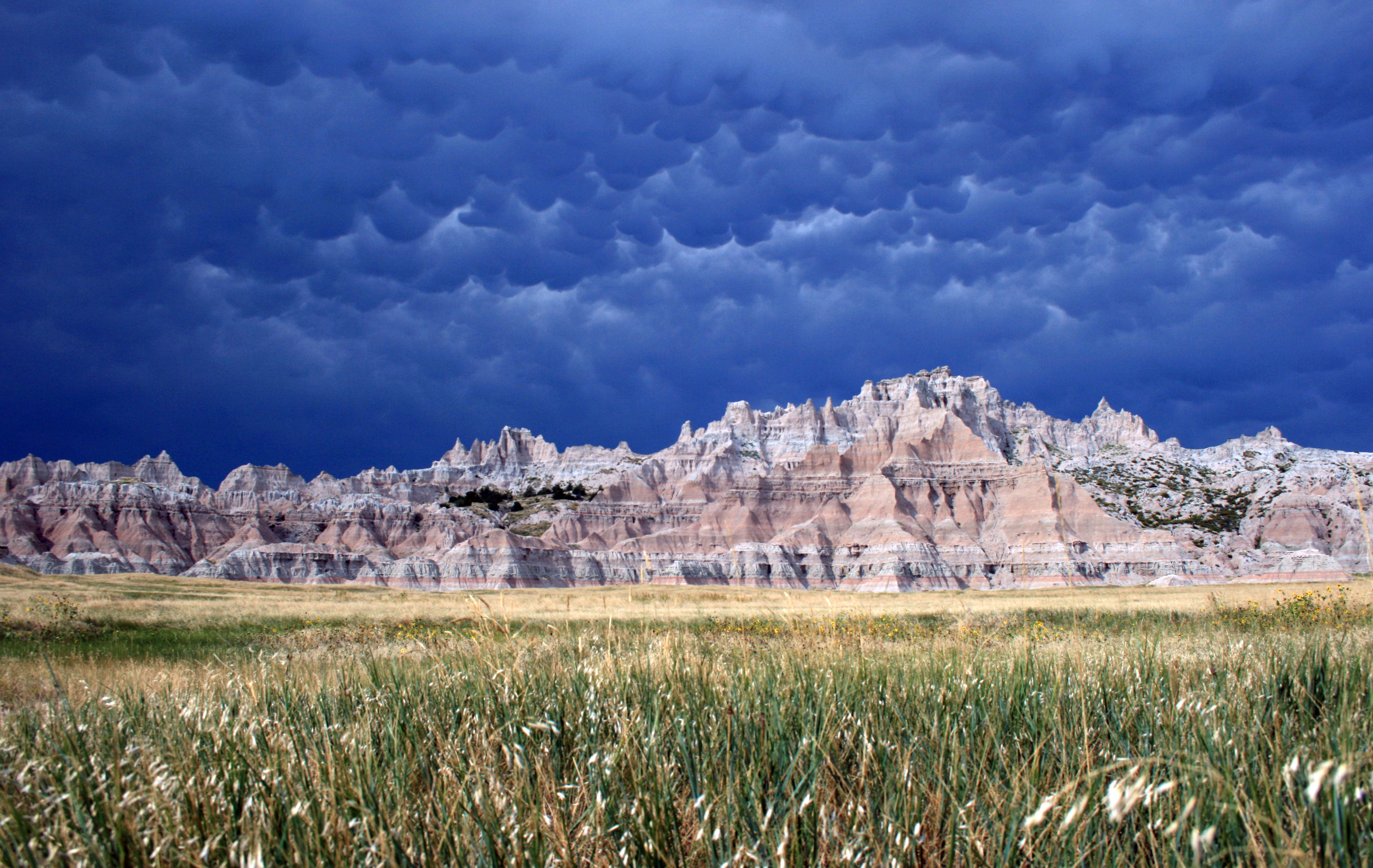
NPS via NPS.gov (Public Domain)
Beginner Guide Badlands National Park Photography Permit
11 min read
Hiking Guide
Navigate Badlands' raw, exposed terrain and its deceptive vertical climbs. Your 2026 guide to hiking, photography permits, and route-finding.
This article contains affiliate links — we may earn a small commission at no extra cost to you.
The Nature of Travel Here
Hiking the Badlands means traversing a raw, exposed landscape rather than following forested paths. You'll encounter terrain that shifts from packed dirt to loose gravel and slick clay, especially after any moisture. Key concerns are relentless sun exposure, rapidly changing weather, and route-finding across open prairie or along formation edges where trails can fade. First-timers consistently misjudge the verticality; slopes that appear gentle from park roads often involve steep, crumbling ascents. Across 244,000 acres, the challenge lies not just in distance but in the physical demand of movement. This is no casual stroll—it's direct engagement with the elements.
The most frequent error visitors make is approaching this terrain like a typical park hike. Carry significantly more water than anticipated, wear footwear with substantial ankle support, and maintain constant awareness of the sky. Summer temperatures can reach 116°F, with thunderstorms developing without warning—hail occurs regularly. Winter brings temperatures down to -40°F, accompanied by winds that scour the open prairie. In my experience, unpreparedness for the scale and severity of conditions remains the primary issue we address. While trail distances may appear modest, the effort required is substantial.
Notch Trail: The Ladder Climb with a Payoff
Distance: 1.5 miles round trip
Elevation Gain: About 200 feet
Trailhead & Parking: The trailhead is at the Door and Window parking area, mile marker 2.5 on the Badlands Loop Road (SD 240). This is one of the most popular lots in the park. It fills by 9:30 AM on summer weekends. Overflow parking stretches along the road shoulder, but rangers will ticket you if you block traffic or vegetation. Get here early or plan for late afternoon.
The Trail: The trail starts flat across a mixed-grass prairie before dropping into a narrow canyon. The surface changes from hard-packed dirt to loose, gravelly scree. The defining feature is a 50-foot wooden ladder bolted into a crack in the wall. The rungs are solid, but the climb is vertical and exposed. After the ladder, the trail narrows here to a ledge walk with a significant drop-off on one side - about the width of a sidewalk. A cable handrail is bolted into the rock for most of this section. The final approach opens to the Notch, a dramatic break in the wall.
The Moment: Stepping out of the narrow ledge onto the overlook platform. The view isn't of the Badlands formations, but over them, looking east across the White River Valley. The prairie stretches flat to the horizon, a stark contrast to the eroded chaos at your feet.
What Most Underestimate: The exposure on the ledge walk. It's not technically difficult, but it induces vertigo in those uneasy with heights. The ladder is the photo op, but the ledge is what makes people turn back. Also, the trail is almost entirely unshaded. The sun bakes the canyon walls, creating an oven effect by mid-day.
Best Time: Early morning, for cooler temperatures and the east-facing view in soft light. Late afternoon works, but you'll be hiking back in your own shadow. Avoid entirely during or after rain - the clay becomes slick as grease.

Castle Trail: The Long Haul Through the Formations
Distance: 10 miles round trip (full length). Often done as shorter out-and-back segments.
Elevation Gain: Minimal, about 300 feet total over its length.
Trailhead & Parking: The two primary endpoints are the Fossil Exhibit Trailhead (west) and the Door and Window parking area (east). The Fossil Exhibit lot is larger and less crowded. You can spot-key hike by leaving a car at each, but that requires coordination. The Fossil Exhibit lot rarely fills completely.
The Trail: This is the park's longest maintained trail, and it feels it. The terrain is a mix of packed dirt, prairie grass, and sections of exposed, rolling slickrock. It doesn't climb the formations so much as weave between them, offering a ground-level, immersive perspective. You're fully exposed to sun and wind the entire way. The trail is well-marked with posts, but across the open prairie sections, it's easy to lose sight of the next marker if you're not paying attention.
The Moment: The solitude. Most visitors stick to the short, dramatic trails off the Loop Road. Once you're a mile or two down the Castle Trail, the crowds vanish. The silence is broken only by wind and the occasional bird call. You get a sense of the park's vast, quiet scale that the roadside overlooks can't provide.
What Most Underestimate: The sheer monotony of the open prairie sections under a blazing sun. It's not a visually thrilling hike every step of the way. It's an endurance hike through a big landscape. Carry at least three liters of water per person for the full distance. There is no shade and no water sources.
Best Time: Spring (April-May) or fall (September-October). Summer temperatures make the full 10-mile trek a serious undertaking. An early start is non-negotiable.
Saddle Pass Trail: The Steep Scramble
Distance: 0.7 miles round trip
Elevation Gain: About 300 feet
Trailhead & Parking: The small pullout is at mile marker 12.5 on the Badlands Loop Road. It holds maybe eight cars. If it's full, do not park on vegetation - the prairie soil is fragile. Wait for a spot or come back later.
The Trail: This is less a trail and more a steep, hands-on scramble up a loose, crumbling Badlands wall. The path is a worn groove in the clay and sandstone. Footing is unstable, and you will use your hands for balance. It's a straight-up climb with no switchbacks. The park classifies it as strenuous, and they aren't kidding. It's the most physically intense half-mile you'll do in the park.
The Moment: Cresting the top and turning around. The view back down to the Loop Road and the valley below is sudden and dramatic. You gain perspective fast.
What Most Underestimate: The descent. Going up is a quad-burner, but going down is a tricky, controlled slide on unstable terrain. Trekking poles are highly recommended. This trail is often closed after rain when the clay becomes dangerously slick; check at a visitor center for current conditions.
Best Time: Cool morning hours. The south-facing slope gets full sun and becomes brutally hot. Do not attempt this in the heat of the day.

Door and Window Trails: The Easy Access Views
Distance: 0.75 miles round trip combined
Elevation Gain: Minimal
Trailhead & Parking: Shares the crowded Door and Window lot with the Notch Trail. This is the park's main hub for short walks.
The Trail: These are two separate, flat, paved paths branching from the same boardwalk start. The Window is a 0.25-mile round trip to a natural window in the rock wall framing a view of the canyon below. The Door is a 0.50-mile round trip to a larger opening. The trails are fully accessible and packed with visitors. The sound of the parking lot never fully disappears.
The Moment: For the Window, it's peering through the narrow opening - a natural picture frame. For the Door, it's the cooler air that often flows out of the larger opening.
What Most Underestimate: How crowded and noisy it is. This isn't a wilderness experience. It's a quick, convenient look at the geology. Manage your expectations. It's worth 20 minutes, not half your day.
Best Time: Any time, though sunrise or sunset can be pretty through the openings. It's so short that weather is less of a factor.
Cliff Shelf Nature Trail: A Hint of Green
Distance: 0.5 mile loop
Elevation Gain: About 50 feet
Trailhead & Parking: A dedicated lot at mile marker 10 on the Loop Road. It's moderately sized and usually has space except at peak midday hours.
The Trail: A boardwalk and gravel loop trail that climbs slightly to a shelf against the formations. Because it's a depression, it sometimes holds water, creating a micro-habitat of juniper trees and thicker vegetation. It feels completely different from the surrounding arid landscape. There are a few stairs and an optional spur to a higher overlook.
The Moment: The temperature drop when you step into the shaded juniper grove. The smell of the trees is a sudden, welcome change from the dry prairie air.
What Most Underestimate: The potential for wildlife. This is a reliable spot to see deer, and birds are more abundant here due to the water and cover. It's a good trail for a quiet, easy walk away from the main crowds at Door and Window.
Best Time: Midday, when you'll appreciate the shade the most. It's also a good option when other trails are too hot or windy.

Medicine Root Loop: The Prairie Walk
Distance: 4 miles round trip (combined with Castle Trail)
Elevation Gain: Gentle rolling hills
Trailhead & Parking: Starts from the Saddle Pass Trailhead or connects from the Castle Trail. Use the Saddle Pass parking cautions.
The Trail: This loop branches off the Castle Trail, winding through the mixed-grass prairie away from the formations. It's a trail for experiencing the grassland ecosystem - the sounds, the grasses, the big sky. You'll likely see prairie dog towns and may spot distant bison. The trail is faint in places; keep an eye on the next marker post.
The Moment: The realization of how alive the "empty" prairie is. Sitting quietly, you'll hear insects, birds, and the wind moving through miles of grass.
What Most Underestimate: The navigation. The trail can be obscure. If you lose the posts, you're just standing in a sea of grass. Carry a map, and know how to retrace your steps to the Castle Trail junction.
Best Time: Early morning or late evening for wildlife activity. The golden hour light on the grasslands is exceptional.
Seasonal Trail Conditions
April-May: The best hiking season. Daytime temperatures are mild (50s-70s°F), nights are cool. Trails are generally dry, and the prairie begins to green. Wind is still a constant factor.
June-August: The challenge season. Heat is the primary concern, with temperatures regularly in the 90s and exceeding 100°F. Start hikes by 7 AM. Afternoon thunderstorms are frequent and can bring lightning, hail, and sudden downpours that turn clay trails to slippery mud. Saddle Pass may close after rains.
September-October: Another prime window. Crowds diminish, temperatures return to the 60s and 70s. September can still be warm. Frost is possible by late October. This is the most reliable time for comfortable long-distance hiking like the full Castle Trail.
November-March: Winter hiking. Snowfall is 12-24 inches total, but wind drifts it across trails and roads. Trails may be obscured. Daytime temps can be anywhere from the 20s to 40s, but wind chill is severe. The park is open, but only attempt trails if you are experienced with winter hiking and have appropriate gear. Check road conditions first.

Trailhead Logistics
Parking strategy is simple: arrive early or be patient. The lots for Notch/Door/Window and Saddle Pass fill quickly. The Fossil Exhibit lot for the Castle Trail is your best bet for guaranteed parking. There is no shuttle system in the park; you drive yourself.
Cell service drops out at the park boundaries and is non-existent on most trails. Do not rely on your phone for navigation or emergency communication. Download offline maps and trail information beforehand.
There are no water sources on any trail. Fill all your bottles at the Ben Reifel Visitor Center or the Cedar Pass Lodge area before heading out. The gift shop sells water for $4 a bottle. Bring your own.
For current trail conditions, stop at the Ben Reifel Visitor Center. Rangers post updates on closures (especially for Saddle Pass after rain) and wildlife activity. The backcountry permit office is also here if you plan to camp off-trail.
What to Carry
Footwear is your most critical choice. Light hiking boots or sturdy trail runners with aggressive tread are mandatory. The terrain is abrasive, loose, and uneven. Sandals or smooth-soled shoes are a bad idea.
Water capacity trumps everything else. Carry a minimum of one liter per person per hour of hiking in summer. For the Castle Trail, that's at least three liters. Hydration reservoirs are easier than bottles for drinking on the move.
Sun protection is non-negotiable: wide-brimmed hat, sunglasses, and mineral-based sunscreen (the sweat-proof kind). The sun reflects off the pale rock, doubling the exposure.
A wind shell or light jacket is useful year-round. The wind can whip across the prairie with surprising cold force, even on a warm day.
For the Notch and Saddle Pass trails, many find trekking poles invaluable for stability on the loose descent and the exposed ledge.
A detailed paper map or offline GPS is recommended for the Castle and Medicine Root trails where route-finding is required.
Photography Permit & Practical Takeaways
A common search term for this park is beginner guide badlands national park photography permit. Here's the straightforward answer: no permit is required for personal, non-commercial photography. You can shoot landscapes, wildlife, and family photos to your heart's content. Commercial photographers (for weddings, magazines, stock agencies, etc.) do need a permit, which is arranged through the park's office. For the vast majority of visitors, your entrance fee covers your photography.
- Start Early. This is the single most effective strategy. You'll get parking, cooler temperatures, better light for photos, and a head start on the crowds. Aim to be at the trailhead by 8 AM in summer.
- Water is Your Limiting Factor. When your water is half gone, turn around. There are no bail-out options on trail.
- Watch Your Feet, Then the Sky. The terrain demands constant attention for footing. But every 20 minutes, stop and scan the horizon for weather. Storms move fast.
- The Loop Road is Your Lifeline. Most trails either start from it or parallel it. If you get turned around, generally heading downhill will lead you back to the road.
- Respect the Prairie. Stay on established trails. The soil crust is fragile, and your footprints can last for years. This is especially critical when parking - don't drive or park on vegetation.
- Bison Are Not Lawn Ornaments. They are wild, unpredictable, and can run three times faster than you. Give them at least 100 yards of space. If you're changing their behavior, you're too close.
- For a deeper dive on trip planning, see our complete visitor guide.
- Your GPS Will Lie. As the park alert states, do not rely on digital navigation to route you to the park. Use the provided physical addresses or follow the signs from I-90.
- Long-distance hiking here is about endurance, not distance. A 5-mile hike in the Badlands can be more taxing than a 10-mile forest hike due to exposure and terrain.
- If you're staying overnight, research your camping options well in advance, as spots fill quickly. For planning the right season, our guide on the best time to visit will be published soon.
Recommended Gear
What experienced visitors bring to Beginner Guide Badlands National Park Photography Permit
Links may earn us a commission at no extra cost to you. We only recommend gear we believe in.
Hiking Essentials
Hydration Pack (3L)
Hands-free water for long trail days
Trekking Poles (Pair)
Save your knees on steep descents
Hiking Boots (Ankle Support)
Sturdy footwear for rocky, uneven trails
Sun & Heat Protection
Wide-Brim Sun Hat
Full coverage UPF 50+ protection at altitude
Insulated Water Bottle (32oz)
Keeps water cold in desert heat all day
Electrolyte Mix Packets
Replace what water alone cannot during intense heat
Winter Gear
Microspikes / Traction Devices
Essential for icy rim trails in winter months
Packable Down Jacket
Lightweight warmth that stuffs into a pocket
Sources
- Official source: NPS — Badlands National Park nps.gov/badl/index.htm
Photo Gallery
More to Explore

Park Guide
Acadia National Park: Carriage Roads, Cadillac Mountain & 2026 Guide
Discover carriage roads, Cadillac Mountain, and rugged Maine coast. Complete 2026 guide to Acadia National Park — trails, fees, lodging, permits, and what rangers recommend.

Hiking Guide
Grand Canyon Hiking Trails: Day Hikes, Water Sources & Rim to Rim
Compare Grand Canyon hiking trails: Bright Angel, South Kaibab, Hermit, Grandview, and rim to rim, with distances, elevation, water stops, and trailhead access for each.

Best Of
Best of Glacier Bay National Park
The best of Glacier Bay is reached by boat: ranger-led day tours up the bay to the tidewater glaciers. What's worth it, how to book, and when to go (2026).

Campsite Guide
White Sands Backcountry Camping: Closed for 2026 — What to Know
As of 2026, backcountry camping at White Sands National Park is closed for site rehabilitation. What that means, and where to camp nearby instead.

Weather Guide
Guadalupe Mountains National Park Weather: Weather
Guadalupe Mountains National Park: weather guide guide updated 2026. Practical visitor information, reservations, and seasonal tips worth bookmarking before

Best Of
Best of Cuyahoga Valley National Park: Best Things to Do
Seeing a Cleveland Orchestra concert with the woods as your backdrop is a uniquely Cuyahoga Valley experience.
Sign in to join the conversation.
Sources & Attribution
Location data courtesy of the National Park Service (U.S. Department of the Interior). NPS data is public domain. Official NPS page.
Images: NPS; NPS; NPS; NPS; NPS.
Map data © OpenStreetMap contributors.
Park operations alerts: NPS.gov · Weather and weather hazards: National Weather Service · Live conditions.
Information may change. Always verify fees, hours, and conditions directly with the official source before visiting.
Did this guide help? Share it with a friend.