Petrified Forest National Park Hiking: Best Hikes at (2026 Guide)
13 min read
Hiking Guide
Skip the 2-hour park tour. 2026 guide to Petrified Forest National Park's best hikes—from half-mile paved loops to mile-long badlands walks worth the slow pace.
This article contains affiliate links — we may earn a small commission at no extra cost to you.
Advertisement
What Hiking Here Actually Means
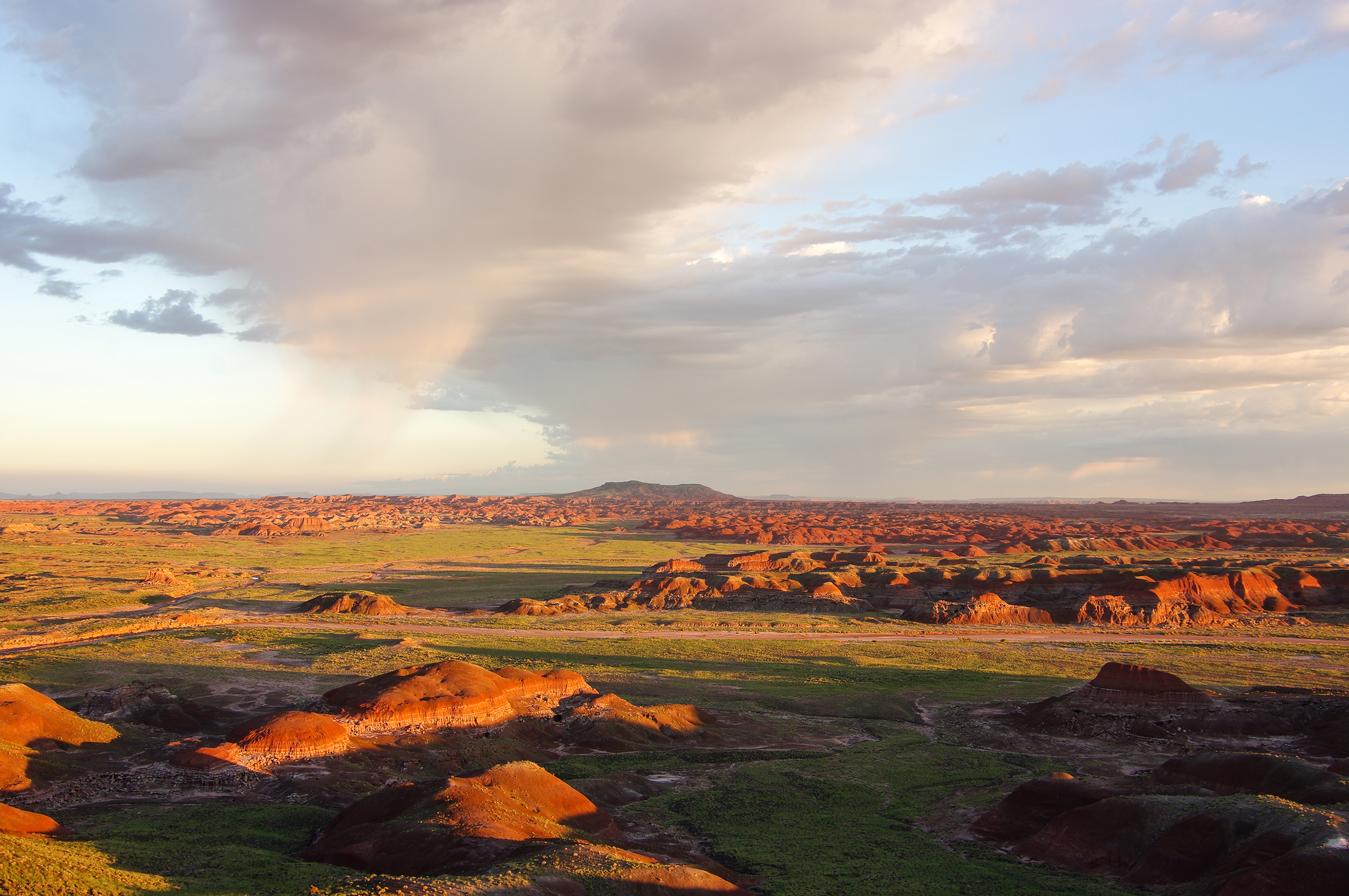
The single thing most hikers underestimate about this park: it's not a backcountry destination. The 28-mile park road connects a series of short, self-guided trails that range from half-mile paved loops to a few mile-long walks into the badlands. You're not going to find a 10-mile trail with 3,000 feet of elevation gain here. What you will find is a landscape that demands you slow down and look closely - at the ground beneath your feet, at the banded hills on the horizon, at the 225-million-year-old logs scattered across the desert floor.
Advertisement
Most first-time visitors try to "hike" the whole park in two hours and end up missing what makes it worth stopping. The real hiking experience here is about timing: being on the right trail when the light hits the badlands, walking Blue Mesa at sunrise, or catching the late afternoon shadows that make the petrified wood pop. The trails are short, but the conditions - full sun exposure, no shade, temperatures that swing 40 degrees between morning and afternoon - make them more demanding than the mileage suggests. Bring water. Bring more than you think you need. And plan on spending at least four hours if you want to hit the six best walks.
The park has two distinct zones. The northern section along I-40 is Painted Desert territory - overlooks above the colorful Chinle Formation badlands. The southern section near the Rainbow Forest Museum holds the densest concentrations of petrified wood. A through-drive takes about 45 minutes without stops. With hiking, expect the full day.
Signature Trails
Blue Mesa Trail: The One You Should Not Miss
Distance: 1 mile loop
Elevation Gain: 80 feet (all in the first quarter mile)
Trailhead & Parking: Located at the Blue Mesa overlook, roughly at the midpoint of the park road about 13 miles south of the north entrance. The lot holds about 30 vehicles. It fills by 10 AM in spring and fall. Overflow parking is limited to the shoulder, which is narrow. The park service recommends arriving early or late.
The Trail: This is the closest thing the park has to a "real hike." The trail drops steeply from the mesa top via a paved section that transitions to gravel as it enters the badlands. You'll walk among blue, purple, and gray banded hills that look like something from another planet. The loop is well-defined and easy to follow, but the surface shifts from packed gravel to loose sand in sections. The climb back up is the same route you descended - and it's noticeably steeper going out than coming in. Take your time on the return.
The Moment: About halfway around the loop, the trail opens onto a wide basin where the banded hills encircle you completely. The colors change with every cloud shift - blue to lavender to almost orange depending on the light. Stand still for a minute. The quiet is remarkable.
What Most Underestimate: The exposure. There is zero shade on this trail. The badlands absorb heat and radiate it back. On a 90-degree day, the trail surface temperature runs 15-20 degrees hotter. Rangers will tell you this is the most common spot for heat-related issues in the park.
Best Time: Sunrise or late afternoon. The low angle light makes the badland bands pop. Midday washes out the colors entirely. Winter months (November-February) offer the best light and coolest hiking temperatures.
Crystal Forest Trail: The Classic Petrified Wood Walk
Distance: 0.75 mile loop
Elevation Gain: Minimal (less than 30 feet)
Trailhead & Parking: Southern end of the park, 2 miles north of Rainbow Forest Museum. The lot is large - holds about 50 vehicles. Parking is rarely an issue here.
The Trail: A fully paved, wheelchair-accessible loop that winds through one of the densest concentrations of petrified wood in the park. The trail is named for the quartz crystals visible inside broken logs - you'll see them catching light if you look closely. The logs here are massive, some spanning 10-15 feet in length with cross-sections that reveal the original tree rings preserved in stone. The trail is flat and easy, suitable for all fitness levels.
The Moment: About halfway around the loop, there's a cluster of logs that have split open to reveal crystalline interiors. In the morning light, the quartz faces catch the sun and throw bright reflections. It's subtle, not dramatic - the kind of detail you'd miss if you were walking fast.
What Most Underestimate: The temptation to touch or take wood. It's illegal to remove any petrified wood from the park - fines start at several hundred dollars. But the bigger issue is that visitors spend so much time looking at the ground they forget to look up at the surrounding badlands and the Painted Desert in the distance.
Best Time: Any time of day, though early morning (8-10 AM) has the best light for the crystal faces. The paved surface makes this a good option for midday when other trails are too hot.
Giant Logs Trail: The Big Ones
Distance: 0.4 mile loop (shaped like a butterfly - two interconnected loops)
Elevation Gain: Minimal
Trailhead & Parking: Directly behind the Rainbow Forest Museum. The lot serves both the museum and the trail. Park in the main museum lot.
The Trail: This is where you'll find the largest petrified logs in the park, including "Old Faithful," a log that measures 10 feet in circumference. The trail is paved and easy, with interpretive signs at each major log explaining the species of tree (mostly Araucarioxylon arizonicum) and the fossilization process. The loop is quick - 20 minutes if you're moving, 45 if you stop to read every sign.
The Moment: Old Faithful. It's the first major log you encounter, and its sheer size surprises most people. A tree that was alive during the Triassic, now turned entirely to agate and quartz, lying across the desert floor. You can see the growth rings preserved in cross-section.
What Most Underestimate: How much there is to see at the Rainbow Forest Museum itself. Plan an extra 30-45 minutes inside for the paleontology exhibits and the working fossil prep lab. The lab is staffed Wednesday through Saturday, 9 AM to 3 PM, and you can watch technicians cleaning fossils in real time.
Best Time: Anytime. This is a good "first stop" trail when you enter from the south, or a "last stop" before heading out.
Photo: NPS via NPS.gov (Public Domain)
Moderate Walks Worth Your Time
Long Logs Trail
Distance: 0.5 mile paved loop
Elevation Gain: Minimal
Trailhead & Parking: Just past Rainbow Forest Museum, 0.5 miles south on the park road. Small lot, about 15 spaces.
The Trail: This trail sits at the base of purple and gray badlands and features one of the highest concentrations of petrified wood in the park. The logs here are notable for their length - some exceed 100 feet, making them the longest complete logs in the park. The paved surface is flat and easy. This trail connects to the unpaved Agate House Trail if you want to extend your walk.
The Moment: The logs here are scattered like a giant's game of pick-up-sticks, some still showing branch patterns and bark texture. The contrast between the purple-gray badlands behind them and the deep reds and oranges of the wood itself is striking.
What Most Underestimate: The connection to Agate House. Most visitors walk the Long Logs loop and stop. But a 0.5-mile unpaved continuation leads to Agate House, a reconstructed ancestral Puebloan dwelling built entirely from petrified wood. It's worth the extension.
Best Time: Late afternoon, when the low sun lights up the badlands wall behind the logs.
Painted Desert Rim Trail
Distance: 1 mile round trip (unpaved)
Elevation Gain: 50 feet
Trailhead & Parking: Starts at the Tawa Point parking area, about 3 miles south of the north entrance. The lot is small - maybe 12 spaces.
The Trail: This unpaved trail winds along the rim of the Painted Desert through a pinyon-juniper woodland. It's not a badlands hike - you stay on top of the mesa, with views down into the colored layers below. The surface is compacted dirt and gravel, suitable for most hikers. The trail connects Tawa Point to the main Painted Desert Visitor Center area.
The Moment: About a quarter mile in, there's a bench positioned perfectly for watching the afternoon light move across the Painted Desert. The layers of mudstone and siltstone shift from pale green to deep red to lavender as the sun angle changes.
What Most Underestimate: The wildlife. This trail runs through the best section of rim woodland for birdwatching. Western meadowlarks, ravens, and occasionally pronghorn are visible from the trail. The vegetation also provides the only real shade on any park trail.
Best Time: Late afternoon. The views are west-facing, and the sunset light over the Painted Desert is the show.
Puerco Pueblo Trail
Distance: 0.75 mile paved loop
Elevation Gain: Minimal
Trailhead & Parking: Located at the Puerco Pueblo site, about 8 miles south of the north entrance. Small lot, about 20 spaces.
The Trail: This is more of a cultural walk than a nature hike, but it's worth including for the history. The paved loop circles the remains of a 100-room masonry pueblo occupied by ancestral Puebloan people approximately 600 years ago. You can see room outlines, a partially reconstructed kiva, and petroglyphs on the boulders near the trail. The trail is fully paved and flat.
The Moment: The petroglyph panel. About 200 yards in, there's a cluster of boulders covered in spiral and animal designs carved into the desert varnish. The detail is remarkable - some clearly represent birds, others are abstract patterns whose meaning is unknown.
What Most Underestimate: How much of the site remains unexcavated. The visible 100 rooms represent only a fraction of the total settlement. The mounds you walk past contain additional rooms that have been left buried intentionally for preservation.
Best Time: Morning, before the sun gets high. The petroglyphs show best in low-angle light.
Quick Walks (20 Minutes or Less)
Tawa Trail
Distance: 0.6 mile one way (1.2 mile out-and-back)
Elevation Gain: Minimal
Trailhead & Parking: Tawa Point parking area, shared with the Painted Desert Rim Trail.
The Trail: A paved trail that follows the rim from Tawa Point to the main Painted Desert Visitor Center area. It's essentially a shorter, paved version of the Rim Trail. The surface is smooth and wheelchair-accessible. This connects to the Rim Trail at both ends if you want to extend your walk.
The Moment: Tawa Point itself. The overlook provides a wide view of the Painted Desert's northern section, with the Chinle Formation's colored bands clearly visible.
Best Time: Late afternoon for sunset views.
Agate House Trail
Distance: 0.5 mile one way (1 mile out-and-back)
Elevation Gain: 30 feet
Trailhead & Parking: Same lot as Long Logs Trail. Look for the unpaved continuation at the far end of the Long Logs loop.
The Trail: An unpaved trail connecting Long Logs to Agate House. The surface is compacted sand and gravel, easy walking. The destination is a small reconstructed pueblo made entirely from petrified wood, including the roof beams. It's the only structure of its kind in the park.
The Moment: Standing inside Agate House. The walls are solid petrified wood, set in mortar. The roof has been reconstructed with modern materials, but the walls are original. You can touch the petrified logs that the ancestral Puebloans cut and stacked 600 years ago.
Best Time: Same as Long Logs - late afternoon.
Photo: NPS via NPS.gov (Public Domain)
Seasonal Trail Conditions
Winter (December-February): Daytime temperatures range from 30-50°F. Nighttime drops below freezing. Snow is infrequent but possible - the park averages about 10 inches of moisture annually, some of which falls as snow. Trails remain open unless ice makes the paved sections hazardous. This is the best season for hiking because the low sun angle produces dramatic light on the badlands, and the cooler temperatures make the exposed trails comfortable. The park road can close briefly during snow events. Check conditions before driving.
Spring (March-May): The busiest season. Temperatures range from 50-80°F. Winds pick up in March and April - expect sustained 20-30 mph gusts. Trails are dry and in good condition. Wildflowers appear in late March and April, concentrated along the Painted Desert Rim Trail and in the grasslands. Parking lots fill by 9:30 AM on weekends.
Summer (June-August): Hot. Daytime highs regularly exceed 95°F, with July and August hitting 100°F+. Afternoon thunderstorms develop in July and August, bringing lightning and flash flood risk. The Blue Mesa Trail and Crystal Forest Trail are dangerous during heat events. Hike before 10 AM or after 4 PM. Carry at least 1 liter of water per hour of hiking. The monsoon storms are dramatic but short - they clear within an hour, leaving behind cooler air and excellent light.
Fall (September-November): The best hiking season. Temperatures range from 60-85°F in September, dropping to 40-65°F by November. Light is golden. Crowds thin after October. Trails are in peak condition. September still carries afternoon thunderstorm risk. October and November offer the most reliable hiking weather.
Trailhead Logistics
Parking strategy: The two busiest lots are Blue Mesa (fills by 10 AM in peak season) and the Painted Desert Visitor Center area (fills by 9:30 AM). All other lots rarely fill completely except on holiday weekends. If Blue Mesa is full, try again after 2 PM when the morning crowds have moved through. The park road is a single 28-mile point-to-point with no shortcuts - you can't skip around a full lot. Plan your route from south to north or vice versa rather than backtracking.
Cell service: It drops out at the north entrance and remains unreliable through the central section of the park. The Rainbow Forest Museum area and the Painted Desert Visitor Center have the strongest signals. Don't rely on your phone for navigation on any trail - download maps in advance. The trails are well-signed, but GPS navigation apps won't work in the badlands where reception is nonexistent.
Water sources: The only potable water is at the Painted Desert Visitor Center and Rainbow Forest Museum. There are no water fountains on any trail. The Painted Desert Oasis gas station sells bottled water ($3-4 per bottle as of 2026). Fill up at the visitor centers before heading out. Expect to carry 1-2 liters for a half-day of hiking.
Ranger station for trail conditions: The Painted Desert Visitor Center (operating from the Painted Desert Inn during construction) and the Rainbow Forest Museum both have current trail condition information. Ask about trail surface conditions on Blue Mesa - the gravel section can wash out during monsoon storms, and rangers will know if it's been repaired. The visitor center phone number is 928-235-2467 (as of 2026).
Photo: NPS via NPS.gov (Public Domain)
What to Carry
The gear list for this park is different from what you'd pack for a mountain hike. The key factors: no shade, extreme temperature swings, and trail surfaces that range from paved to loose gravel to deep sand.
Footwear: Trail runners or light hiking shoes with good grip. You don't need boots for the paved trails, but the unpaved sections of Blue Mesa and the Agate House Trail have loose gravel that can be slick on smooth soles. Trail runners with Vibram-style soles are the sweet spot. Avoid sandals on any unpaved trail - the gravel and sand get between your foot and the sole, causing blisters.
Water system: Carry 2 liters minimum for a half-day. A hydration bladder works well because you don't have to stop to drink. The exposed trails dehydrate you faster than you'd expect from the mileage. If you're hiking Blue Mesa in summer, bring 3 liters.
Sun protection: Wide-brimmed hat, sunglasses, and sunscreen (SPF 50 minimum). The elevation is 5,400-5,800 feet, and the open sky means intense UV exposure. You'll burn in 20 minutes on a clear day even in winter when the temperature is cool.
Layers: A fleece or light jacket for early morning starts, even in summer. Temperatures at sunrise can be 30°F cooler than the afternoon high. In winter, add a wind shell - the Painted Desert Rim is exposed to persistent wind.
What you don't need:Trekking poles (trails are short and not steep enough to justify them), bear spray (no bears in this park), rain gear beyond a light packable shell (summer storms are intense but brief), or heavy backpacks (the longest trail is 1 mile round trip).
Practical Takeaways
Start at the south end (Rainbow Forest Museum) and work north. The best trails are clustered there, and you'll hit them before the crowds arrive. The Painted Desert overlooks at the north end are best in late afternoon light anyway.
The park road is 28 miles point-to-point with no gas stations between the north and south ends. Fill your tank in Holbrook or at the Painted Desert Oasis before entering.
The Blue Mesa trailhead fills first. If you arrive after 9:30 AM and the lot is full, skip it and come back after 2 PM. Do not park on the road - the shoulder is narrow and rangers will ticket.
Arizona does not observe Daylight Saving Time. From March through November, the park is on Mountain Standard Time, which means sunrise is later and sunset is earlier than you'd expect. Plan your early morning hikes accordingly.
The most common mistake: trying to "hike" the park by driving to every overlook and walking 100 yards to the rail. The real experience is on the three trails that descend into the landscape: Blue Mesa, Crystal Forest, and the full Long Logs-Agate House combo.
Cell service drops completely in the central section of the park. Download the NPS app and the park's offline trail maps before you arrive. The park has free WiFi at the Painted Desert Visitor Center and Rainbow Forest Museum.
The best hikes at Petrified Forest National Park are short, but they reward slow travelers. Plan 20-30 minutes per trail minimum. Rushing through Blue Mesa in 15 minutes defeats the purpose.
Dogs are allowed on all paved trails but not on unpaved surfaces. The Blue Mesa Trail's gravel section is off-limits to pets. The Painted Desert Rim Trail and Agate House Trail are also dog-free. Stick to Crystal Forest, Giant Logs, Puerco Pueblo, and Tawa if you're hiking with your dog.
The park is open 8 AM to 5 PM, but you can enter as early as 7 AM if you have a reservation or pass. The gate is staffed starting at 8 AM. If you arrive before staff, you can proceed and pay at the visitor center.
Hotel options are in Holbrook (19 miles south) or along I-40. There is no lodging inside the park. For detailed recommendations, see the Petrified Forest camping guide and best time to visit page for seasonal planning.