For more, see best time to visit.
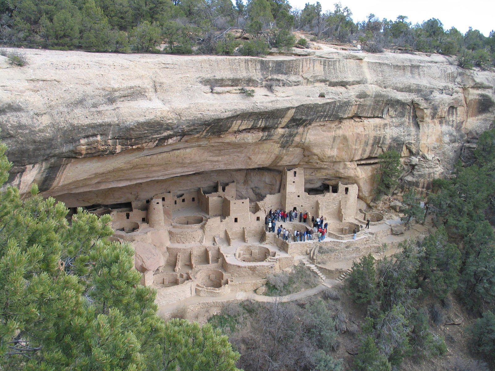
NPS via NPS.gov (Public Domain)
The Ultimate Guide to best hikes in mesa verde national park
10 min read
Hiking Guide
Complete 2026 hiking guide for Mesa Verde National Park. Trails, difficulty ratings, seasonal conditions, and practical tips for every skill level.
This article contains affiliate links — we may earn a small commission at no extra cost to you.
Mesa Verde National Park Hiking: Best Hikes In (2026 Guide)
What Hiking Here Actually Means
Forget wilderness solitude or peak-bagging. At Mesa Verde, you're walking through a 700-year-old neighborhood. These trails connect mesa-top pueblos to cliff dwelling overlooks, with every elevation change reminding you why the Ancestral Puebloans chose these sites—for defense and resource access. By day's end, your legs will understand both reasons.
Most first-time visitors underestimate two things: the altitude and the sun. The park road climbs from around 7,000 feet at the entrance to over 8,500 feet on the mesa tops. Combine that with relentless Colorado sun reflecting off light sandstone, and a two-mile hike can drain you faster than a desert ten-miler. Rangers will tell you that the most common assistance calls are for dehydration and mild altitude headaches from hikers who brought a single 16-ounce water bottle. The other common mistake is treating this like a museum walk - it's not. These are irreplaceable archaeological sites. Stay on the trail, don't touch the walls, and leave every artifact exactly where you found it.
Petroglyph Point Trail: The Definitive Mesa Verde Hike
Distance: 2.4 miles round-trip
Elevation Gain: 300 feet
Trailhead & Parking: The trail starts from the Spruce Tree House overlook area, near the Chapin Mesa Archeological Museum. Parking here is a constant challenge. The lot is small and services the museum, the only year-round restrooms on the mesa, and the trailhead itself. It's often full by 10:30 AM. If you find it full, your best bet is to park at the nearby Chapin Mesa picnic area and walk the half-mile back along the road. Do not park on vegetation or block traffic.
The Trail: This is a loop, but everyone goes counter-clockwise. You start by descending a series of stone steps and metal staircases into Spruce Canyon. The trail narrows here, clinging to the base of the cliff. The surface is a mix of packed dirt, slickrock, and loose gravel. You'll pass directly beneath the towering Spruce Tree House cliff dwelling - a perspective you don't get from the overlook above. The trail then winds through the canyon, pinon-juniper forest giving way to the cool, shaded alcoves of the north-facing cliff. The namesake petroglyph panel is about halfway. You don't have to search for it; the trail puts you right in front of it.
The Moment: Turning the corner to see the petroglyph panel, a dense collection of spirals, handprints, and figures etched into the varnished sandstone, still crisp after centuries. It's not roped off. You're just there with it.
What Most Underestimate: The ladder. To exit the canyon, you climb a 15-foot wooden ladder anchored to the cliff face. It's sturdy and has handrails, but it gives many people pause. If you have a severe fear of heights or are hiking with very young children, this is your turn-back point. There's no alternative route up.
Best Time: Early morning, right when the trail opens. You'll have the petroglyphs to yourself and beat the museum crowds. Late afternoon sun lights up the canyon walls, but that's also when summer thunderstorms roll in.

Soda Canyon Overlook Trail: The Effort-to-View Ratio Winner
Distance: 1.2 miles round-trip
Elevation Gain: Minimal
Trailhead & Parking: The trailhead is a dedicated pullout on the road to Balcony House, about a mile past the museum junction. It has space for about 15 cars. It rarely fills completely because most visitors are rushing to the ticketed cliff dwellings. It's paved and accessible.
The Trail: This flat, paved path leads to three overlooks into Soda Canyon. It's more of a stroll than a hike—completely exposed, with no shade. Benches at each overlook offer a place to rest.
The Moment: From the final overlook, you get a straight-on, unobstructed view of the Balcony House cliff dwelling across the canyon. You can see the ladder the tour groups use to enter and the tunnel they crawl through. It's the best free view of an intact dwelling in the park.
What Most Underestimate: The wind. The canyon acts as a wind tunnel, and gusts can be strong enough to knock a hat off. Hold onto your map and secure anything light in your pack.
Best Time: Any time of day. It's a perfect short leg-stretcher on the drive to or from the mesa top. Sunset here is quiet, as most visitors have left for the day.
Prater Ridge Trail: For When You Need to Escape the Crowds
Distance: 7.8 mile loop
Elevation Gain: 1,000 feet
Trailhead & Parking: Starts at the Morefield Campground amphitheater parking lot. Since it's in the campground area, 4 miles from the park entrance, parking is almost always available. It's the trailhead least affected by the main park road congestion.
The Trail: A lollipop loop that climbs onto Prater Ridge, offering 360-degree views of the surrounding Montezuma Valley, the La Plata Mountains, and the park's main mesas. The first mile is a steady, sun-exposed climb. Once on the ridge, the trail alternates between scrub oak thickets and open meadows. The footing is good - packed dirt with some rocky sections. You'll see more mule deer and ravens here than people.
The Moment: Reaching the high point on the northern end of the loop, where the park sprawls behind you and the vast, arid valley stretches north. It's the only trail that gives you a true sense of the mesa's isolation.
What Most Underestimate: The exposure and lack of water. There is zero shade on the ridge for miles. The sun and wind are relentless. Carry at least three liters of water per person from May through September.
Best Time: Spring (May) or fall (late September-October). Summer temperatures on the exposed ridge are punishing. Mornings are always better than afternoons.

Knife Edge Trail: A Piece of History
Distance: 2.0 miles round-trip
Elevation Gain: 200 feet
Trailhead & Parking: Located near the park entrance, just past Morefield Campground. A small, paved lot holds about 10 cars. It's often empty because it's not near any cliff dwellings.
The Trail: This follows the original roadbed into the park, built in 1914. It's wide, gravel, and follows a narrow ridge with steep drop-offs on both sides - hence the name. It's an out-and-back to an overlook of the Montezuma Valley. The historical markers along the way are worth reading; they explain the sheer effort it took to build access to this place.
The Moment: Standing at the end where the old road simply ends at the cliff edge, imagining a Model T navigating that narrow track. The view of the valley is secondary to the sense of history.
What Most Underestimate: It can be incredibly windy. The narrow ridge funnels any breeze. On a calm day, it's an easy walk. On a windy day, it feels adventurous.
Best Time: Late afternoon for photography. It's also a good option if you arrive after the main park road has closed for the night (the gate near Morefield is open 24/7).
Point Lookout Trail: The Panoramic Payoff
Distance: 2.2 miles round-trip
Elevation Gain: 500 feet
Trailhead & Parking: Starts at the back of the Morefield Campground, near the group camping area. Parking is plentiful. This is the steepest sustained climb in the park, so the trailhead is never crowded.
The Trail: A relentless series of switchbacks carved into the side of Point Lookout, the prominent mesa you see from the valley. The trail is well-graded but never lets up. It's all sun-exposed, with a surface of loose gravel and sandstone steps. The top is a flat, rocky summit.
The Moment: The 360-degree view from the top. To the north, the entire Montezuma Valley. To the south, the park's inner canyons and the distant San Juan Mountains. You can trace the entire winding park road from up here.
What Most Underestimate: The descent. Going down the loose gravel can be hard on the knees and slippery. Trekking poles are highly recommended for this trail.
Best Time: Early morning, before the sun bakes the south-facing slope. Sunset hikes are popular, but bring a headlamp for the trip down.

Farming Terrace Trail: A Quiet, Educational Loop
Distance: 0.8 mile loop
Elevation Gain: Minimal
Trailhead & Parking: The trailhead is an unmarked pullout on the Mesa Top Loop Road, between the Square Tower House and Sun Point overlooks. Space for 4-5 cars. Most people drive right past it.
The Trail: A flat, easy loop through a series of restored check dams and farming terraces used by the Ancestral Puebloans. Interpretive signs explain how they captured and directed scarce rainwater to grow crops in this arid environment. It's more of an open-air exhibit than a traditional hike.
The Moment: The realization of how much engineering and labor went into simple survival. Seeing the terraces makes the cliff dwellings feel even more impressive.
What Most Underestimate: The mosquitoes. This is one of the few places in the park that can hold standing water after a rain, breeding mosquitoes from spring through summer. Bring repellent.
Best Time: Spring, when water might actually be running through the terraces, or fall.
Seasonal Trail Conditions
May - June: This is the sweet spot. Daytime temperatures are in the 60s and 70s (°F), trails are dry, and the pinon-juniper forest is green. Snow is possible but rare on the mesa tops after early May. Cliff dwelling tours begin, so trail traffic increases.
July - August: Heat. Temperatures on exposed trails like Prater Ridge or Point Lookout can feel well over 100°F with solar radiation. Afternoon thunderstorms are a daily occurrence from mid-July on. Start hikes by 7 AM and be off high points by noon. The trails are packed; parking at popular trailheads is full by 9 AM.
September - October: The best time for hiking. Crowds thin after Labor Day, temperatures are perfect (50s-70s), and the air is clear. Watch for early snowstorms in October that can temporarily close trails. Most guided tours of Mesa Verde operate into late October.
November - April: Winter. The Wetherill Mesa road and most services are closed. The only plowed road goes to the Chapin Mesa museum. Hiking is limited to trails near the museum (Petroglyph Point is often closed due to ice on the ladder) and the lower-elevation Knife Edge. You'll need microspikes for any trail after a snow. Check the complete visitor guide for winter road status.

Trailhead Logistics
Parking strategy dictates your day. The Chapin Mesa museum area is the epicenter of congestion. If your goal is Petroglyph Point or the Mesa Top Loop trails, be parked by 9 AM. After that, use the overflow at the Chapin Mesa picnic area.
The park operates a shuttle bus on the Mesa Top Loop Road from mid-May to mid-October. It's designed to reduce traffic, not necessarily for hiker convenience, but you can use it to connect trailheads. For example, park at the museum, take the shuttle to the Far View sites, and hike back.
Cell service drops out at the park entrance. Assume you will have no signal for your entire visit. Download maps, trail info, and your park pass to your phone before you arrive. The only reliable water sources are at the Chapin Mesa museum, the picnic area, and Morefield Campground. There is no potable water on any trail.
For current trail conditions, stop at the Visitor and Research Center at the entrance or the Chapin Mesa Archeological Museum. Rangers post updates on closures (often for ice, mud, or archaeological stabilization work).
What to Carry
Forget the generic list. Here's what matters for Mesa Verde's specific conditions:
Water: Carry a minimum of one liter per person for every two hours you plan to be out, plus an extra liter. For a hike like Prater Ridge in summer, that's at least 3-4 liters. Hydration bladders are better than bottles because they encourage sipping constantly.
Footwear: Sturdy hiking shoes with aggressive tread. Not sneakers. The terrain is a mix of slickrock, loose gravel, and sand. Ankle support is useful on the uneven trails near cliff edges.
Sun Protection: A wide-brimmed hat, not a baseball cap. Sunglasses. And mineral-based sunscreen (zinc oxide). The high-altitude UV radiation is intense, and sweat will melt chemical sunscreen into your eyes.
Layers: Even in summer, a light windbreaker or fleece is wise. The temperature can drop 20 degrees quickly in a canyon or when a cloud covers the sun. In spring and fall, carry a warm hat and gloves.
Navigation: A printed park map. Your phone's GPS will work for position, but without cellular data, you won't have map detail. The park trail map is simple and effective.
The Extras: Trekking poles for the descents on Point Lookout or Petroglyph Point. Electrolyte tablets or powder to mix into your water. A bandana to wet and drape on your neck.
Practical Takeaways
- Altitude is your first adversary. Drink twice as much water as you think you need, and go slower than you normally would for the first 24 hours.
- The main parking chaos is between 10 AM and 2 PM at Chapin Mesa. Plan to be at your primary trailhead by 9 AM or after 3 PM.
- Hiking here is about the destination, not the journey. The trails are connectors to archaeological sites. Savor the pauses at the overlooks.
- Reserve your Mesa Verde National Park ranger guided tours for cliff dwellings like Balcony House or Long House the moment they become available (14 days in advance). They sell out.
- If you're camping near Mesa Verde National Park, Morefield Campground inside the park is your most convenient option. It puts you at the trailhead for Point Lookout and Knife Edge, and a 20-minute drive from the main sites.
- The best light for photography is the hour after sunrise and the hour before sunset. Midday light is harsh and flat.
- Check the Mesa Verde National Park website for the current status of Petroglyph Point Trail. The ladder section closes intermittently for ice in winter/spring and sometimes for maintenance.
- Your ticket for a ranger-guided tour does not guarantee a parking spot at that dwelling. You still need to arrive early to find parking and walk to the meeting point.
- Leave the hiking poles in the car if you're taking a cliff dwelling tour. They are not allowed in the dwellings.
- The gift shop sells water for $4 a bottle. Fill your own at the campground or museum.
For more information, see our complete National Park Guide.
Related: guided tours of mesa verde guide
Related: mesa verde guided tours guide
Recommended Gear
What experienced visitors bring to The Ultimate Guide to best hikes in mesa verde national park
Links may earn us a commission at no extra cost to you. We only recommend gear we believe in.
Hiking Essentials
Hydration Pack (3L)
Hands-free water for long trail days
Trekking Poles (Pair)
Save your knees on steep descents
Hiking Boots (Ankle Support)
Sturdy footwear for rocky, uneven trails
Sun & Heat Protection
Wide-Brim Sun Hat
Full coverage UPF 50+ protection at altitude
Insulated Water Bottle (32oz)
Keeps water cold in desert heat all day
Electrolyte Mix Packets
Replace what water alone cannot during intense heat
Winter Gear
Microspikes / Traction Devices
Essential for icy rim trails in winter months
Packable Down Jacket
Lightweight warmth that stuffs into a pocket
Sources
- Official source: National Park Service nps.gov/meve/index.htm
- Official booking/facility record recreation.gov
Photo Gallery
More to Explore

Park Guide
Acadia National Park: Carriage Roads, Cadillac Mountain & 2026 Guide
Discover carriage roads, Cadillac Mountain, and rugged Maine coast. Complete 2026 guide to Acadia National Park — trails, fees, lodging, permits, and what rangers recommend.

Hiking Guide
Grand Canyon Hiking Trails: Day Hikes, Water Sources & Rim to Rim
Compare Grand Canyon hiking trails: Bright Angel, South Kaibab, Hermit, Grandview, and rim to rim, with distances, elevation, water stops, and trailhead access for each.

Best Of
Best of Glacier Bay National Park
The best of Glacier Bay is reached by boat: ranger-led day tours up the bay to the tidewater glaciers. What's worth it, how to book, and when to go (2026).

Campsite Guide
White Sands Backcountry Camping: Closed for 2026 — What to Know
As of 2026, backcountry camping at White Sands National Park is closed for site rehabilitation. What that means, and where to camp nearby instead.

Weather Guide
Guadalupe Mountains National Park Weather: Weather
Guadalupe Mountains National Park: weather guide guide updated 2026. Practical visitor information, reservations, and seasonal tips worth bookmarking before

Best Of
Best of Cuyahoga Valley National Park: Best Things to Do
Seeing a Cleveland Orchestra concert with the woods as your backdrop is a uniquely Cuyahoga Valley experience.
Sign in to join the conversation.
Sources & Attribution
Location data courtesy of the National Park Service (U.S. Department of the Interior). NPS data is public domain. Official NPS page.
Images: NPS; NPS; NPS; NPS; NPS.
Map data © OpenStreetMap contributors.
Park operations alerts: NPS.gov · Weather and weather hazards: National Weather Service · Live conditions.
Information may change. Always verify fees, hours, and conditions directly with the official source before visiting.
Did this guide help? Share it with a friend.